Continental US Maps
to
18
200
5,489
200
198
2
9
9
8
6
5
3
2
2
1
1
1
64
75
59
2
23
19
6
6
6
7
6
2
2
1
3
2
175
52
25
14
13
82
80
65
33
24
200
200
200
2
2
2
2
2
Item Ships From: Continental US
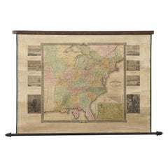
"The United States from the Latest Authorities" Antique Wall Map, 1835
Located in Colorado Springs, CO
This is a 1835 map of “The United States from the Latest Authorities” by Ezra Strong. A hand-colored engraved wall map of the eastern half of the United States, this map has a large inset of the "Oregon District" and several engraved city views and two portraits.
The primary map extends to Mexico Texas and the Missouri Territory, showing the course of the Missouri River to Ft. Mandan and Old Ft. Mandan, and noting many forts along the river. The territories to the east of Missouri Territory are separately delineated as Sioux District and Huron District. The western details of the map are very good for a map of this time period, with many Native American settlements, villages, forts and other details noted.
The map is bordered with vignettes of Boston, New York, Philadelphia, Hartford, Cincinnati, and Baltimore. Each vignette notes the date settled, primary settler, and the population as of 1830. Two portraits of LaFayette and George Washington are presented in full length with related biographical information.
A large inset map at lower right shows the Oregon District, centered on the Columbia River and extending to the Rocky Mountains. This is one of the earliest commercial appearances of a separate map of Oregon...
Category
1830s American Antique Continental US Maps
Materials
Paper
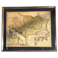
Four 18th Century Engraved and Hand-Colored Maps by Weigel
By Christoph Weigel
Located in Copenhagen, K
Small collection of four engraved maps of Italy, Balkan and of Central Asia.
Two are of Italy, one Corsica and Northern Italy and the other of the Southern Italian boot...
Category
18th Century German Antique Continental US Maps
Materials
Paper
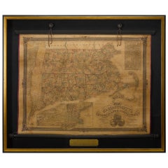
1854 Map of Massachusetts, Connecticut and Rhode Island, Antique Wall Map
Located in Colorado Springs, CO
This striking wall map was published in 1854 by Ensign, Bridgman & Fanning and has both full original hand-coloring and original hardware. This impression is both informative and highly decorative.
The states are divided into counties, outlined in red, green, and black, and subdivided into towns. Roads, canals, and railroad lines are prominently depicted, although they are not all labeled. The mapmakers also marked lighthouses, banks, churches, and prominent buildings, with a key at right. The map is an informative and comprehensive overview of the infrastructural development of New England prior to the Civil War. Physical geographies depicted include elevation, conveyed with hachure marks, rivers and lakes. The impression features an inset map of Boston...
Category
19th Century American Antique Continental US Maps
Materials
Paper
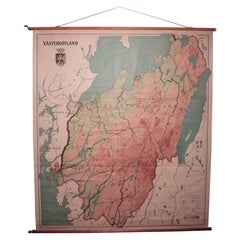
Vintage Swedish School Map of Vastergötland, Made in Sweden 1920
Located in Los Angeles, CA
Vintage Swedish School Map of Vastergötland, Made in Sweden 1920
Västergötland also known as West Gothland or the Latinized version Westrogothia in older literature, is one of the...
Category
1920s Swedish Vintage Continental US Maps
Materials
Linen, Wood, Paper
Original 1910 George Eldridge Chart
Located in Norwell, MA
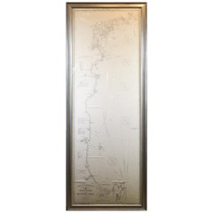
Original framed 1910 George Eldridge chart "E" showing Gloucester to the Kennebec river. Showing the coast of Maine in great detail. Towns includ...
Category
20th Century Unknown Continental US Maps
1918 American Frohse Anatomical Chart, A. J. Nystrom, Max Brodel Illustrator
By Max Brödel, A.J. Nystrom & Co
Located in Buffalo, NY
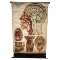
Antique American Frohse Anatomical pull down chart, by A. J. Nystrom, ,revised and augmented by Max Brodel illustrator... Amazing color, patina, age appropriate wear. dated 1918..
Max (Paul Heinrich) Brödel
1870-1941
Brödel, an illustrator and the first director of the Art as Applied to Medicine program at Johns Hopkins...
Category
1910s American Steampunk Vintage Continental US Maps
Materials
Wood, Paper
1865 Chart of the Islands of Madeira
Located in Norwell, MA
Rare James Imray chart from 1865 titled "Chart of the Islands of Madeira, Porto Santo and Dezerea" drawn from the survey made by Captain Ate Vidal Royal Navy, London. Published by Ja...
Category
1860s European Antique Continental US Maps
Materials
Paper
1891 Map of Plymouth County Mass
Located in Norwell, MA
Original 1891 map showing Sandwich, Bourne, Plymouth Carver, Middleborough, Plympton and Kingston. Showing Long Beach in Plymouth also as well as all shore points. Cape Cod Bay is ma...
Category
1890s North American Antique Continental US Maps
Materials
Paper
Chart of Boston's North Shore
Located in Norwell, MA
Rarely found restrike of an 1804 chart by Nathanael Bowditch of the Harbors of Salem, Marblehead, Beverly, and Manchester.
Showing the Islands of Great Misery, Satan, Cuney, Winter,...
Category
1980s North American Vintage Continental US Maps
Materials
Paper
Original 1891 Walker Map
Located in Norwell, MA
Original 1891 map of Massachusetts by Walker. Towns include Cambridge, Boston, Dedham, Ashland, Brookline, Newton etc... burl wood frame. Measures...
Category
19th Century Antique Continental US Maps
Map of Harwich, Massachusetts
Located in Norwell, MA
Turn of the century map of Harwich, Massachusetts. Plate from a Cape Cod County Map book showing the Barnstable county town of Harwich including Allens Harbor, Pleasant Lake, Harwich...
Category
20th Century Continental US Maps
1562 Map of Toscana Nuova Tavola by Girolamo Ruscelli
Located in Chapel Hill, NC
A 1562 map of Toscana Nuova Tavola by Girolamo Ruscelli. Tuscany is the heart of Italy & birthplace of the Italian language. Early hand-coloring. Copper plate engraving. Interestingl...
Category
16th Century Italian Renaissance Antique Continental US Maps
Materials
Paper
Antique Framed Pen and Ink on Fabric Map of Cornwall from Early 19th Century
Located in Los Angeles, CA
This English fabric map of Cornwall, rendered in pen-and-ink, showcases exquisite hand-drawn details and charming faded sepia tones. Encased in a classic frame, this piece elegantly ...
Category
Early 19th Century English Antique Continental US Maps
Materials
Walnut, Fabric
Engraving Depicting 16th Century Map of Terra Sancta
Located in Buchanan, MI
Abraham Ortelius (Flemish, 1527-1598) Terra Sancta.
Engraving depicting 16th century map of Terra Sancta. Site 15" x 19.5.
Category
18th Century and Earlier Antique Continental US Maps
Materials
Paper
1891 Map of Norfolk County Massachusetts
Located in Norwell, MA
1891 map of Norfolk county Massachusetts including the towns of Wrentham, Franklin, Medfield, Sherborn, Norwood etc., measures: 23 x 31.
Category
19th Century Antique Continental US Maps
Large 1848 North America & Territories Map
Located in Stamford, CT
Framed 1848 S. Augustus and Mitchell, Philadelphia , PA North America and territories map.
Featuring the United States, Canada (British Territory) and Mexican Territories.
As found...
Category
1840s American American Classical Antique Continental US Maps
Materials
Glass, Wood, Paper
Framed 1838 North America & Recent Discoveries Map
Located in Stamford, CT
1838 map of North America & recent discoveries. Engraved color map by J. Wyld, London, England. This map shows Texas as a Republic without its panhandle.
Framed in brown carved wood...
Category
1830s American American Classical Antique Continental US Maps
Materials
Glass, Wood, Paper
1830 Mexico and United States Framed Map
Located in Stamford, CT
Map of North America published circa 1830. Map shows United States into Canada. Mexico extending into the upper California territory. Texas appears in name but prior to the period of...
Category
1830s American American Classical Antique Continental US Maps
Materials
Glass, Wood, Paper
Framed 1839 Hand Colored Map of the United States
Located in Stamford, CT
Framed hand colored map of the United States of America from 1839. Newly framed in a giltwood frame.
Category
1830s American American Classical Antique Continental US Maps
Materials
Giltwood, Paper, Glass
Framed 1820s Hand Colored Map of the United States
Located in Stamford, CT
Framed 1820s hand colored map photos of North America and South America. As found framed in giltwood frame.
Category
1820s American Spanish Colonial Antique Continental US Maps
Materials
Giltwood, Paper, Glass
Recently Viewed
View AllMore Ways To Browse
Wedgwood Green Jasperware
Wedgwood Portrait
West German Pot
White Ceramic Garden Stool
White Ironstone China
White Lacquer Bar Cart
Woman With Water Jug
Wooden Chest 1800
Wooden Tea Cart
Worcester Jug
Wrights Antiques
Yellow Lalique Vase
Yves Saint Laurent Lamps
Zani Italian
17th Century Italian Baroque Commode
17th Century Kano
18th Century Cooking Fireplaces
1930 Dresser With Mirror
