Items Similar to Wine Map of Bordeaux

Want more images or videos?
Request additional images or videos from the seller
1 of 8
UnknownWine Map of Bordeauxca. 1938
ca. 1938
$285
£220.21
€254.59
CA$402.73
A$451.68
CHF 236.54
MX$5,488.40
NOK 3,003.66
SEK 2,847.68
DKK 1,900.35
About the Seller
4.9
Recognized Seller
These prestigious sellers are industry leaders and represent the highest echelon for item quality and design.
Established in 1972
1stDibs seller since 2016
186 sales on 1stDibs
Typical response time: <1 hour
Associations
International Fine Print Dealers Association
- ShippingRetrieving quote...Shipping from: New York, NY
- Return Policy
Authenticity Guarantee
In the unlikely event there’s an issue with an item’s authenticity, contact us within 1 year for a full refund. DetailsMoney-Back Guarantee
If your item is not as described, is damaged in transit, or does not arrive, contact us within 7 days for a full refund. Details24-Hour Cancellation
You have a 24-hour grace period in which to reconsider your purchase, with no questions asked.Vetted Professional Sellers
Our world-class sellers must adhere to strict standards for service and quality, maintaining the integrity of our listings.Price-Match Guarantee
If you find that a seller listed the same item for a lower price elsewhere, we’ll match it.Trusted Global Delivery
Our best-in-class carrier network provides specialized shipping options worldwide, including custom delivery.More From This Seller
View AllTwo-Part Large Hand-Colored Map of Europe from 1798
By Thomas Kitchin
Located in New York, NY
Map of Europe printed on two separate sheets from A New Universal Atlas by Thomas Kitchin. Published in London by Laurie & Whittle, 1798. Original engravings hand-colored at publicat...
Category
1790s More Art
Materials
Paper

$1,700 Sale Price
33% Off
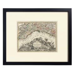
Hand-Colored Map of Genoa, circa 1744
By Matthew Seutter
Located in New York, NY
Seutter, Matthew.
Genova [Genoa].
From Atlas minor praecipua Terrarum Imperia...
Augsburg, circa 1744.
Original engraving with old hand-coloring.
Image size: 7 5/8 x 10 inches.
Materials
Paper
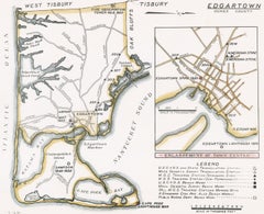
Map of Edgartown, Martha's Vineyard
Located in New York, NY
Original map of Edgartown, Martha's Vineyard with recent hand-coloring, 1938. Light toning to edges; has original holes punched in left edge. From "Massach...
Category
1930s Prints and Multiples
Materials
Paper
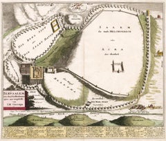
Map of Biblical Jerusalem
Located in New York, NY
Original copper engraving hand-colored at the time of publication. Nuremberg, 1720.
Category
1720s Prints and Multiples
Materials
Paper
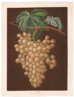
Muscat of ALexandria Grapes by George Brookshaw
By George Brookshaw
Located in New York, NY
Plate LIII, Muscat of Alexandria. from "Pomona Britannica..." by George Brookshaw. London, T. Bensley for the author, 1804-1812. Original aquatint with stipple engraving, color pri...
Category
Early 19th Century Prints and Multiples
Materials
Paper
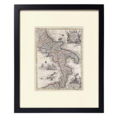
Hand-Colored Map of Southern Italy, circa 1744
By Matthew Seutter
Located in New York, NY
Seutter, Matthew.
Neapolis Regnum...
From Atlas minor praecipua Terrarum Imperia...
Augsburg, circa 1744.
Original engraving with old hand-coloring.
Image size: 10 3/16 x 7 11...
Materials
Paper
You May Also Like
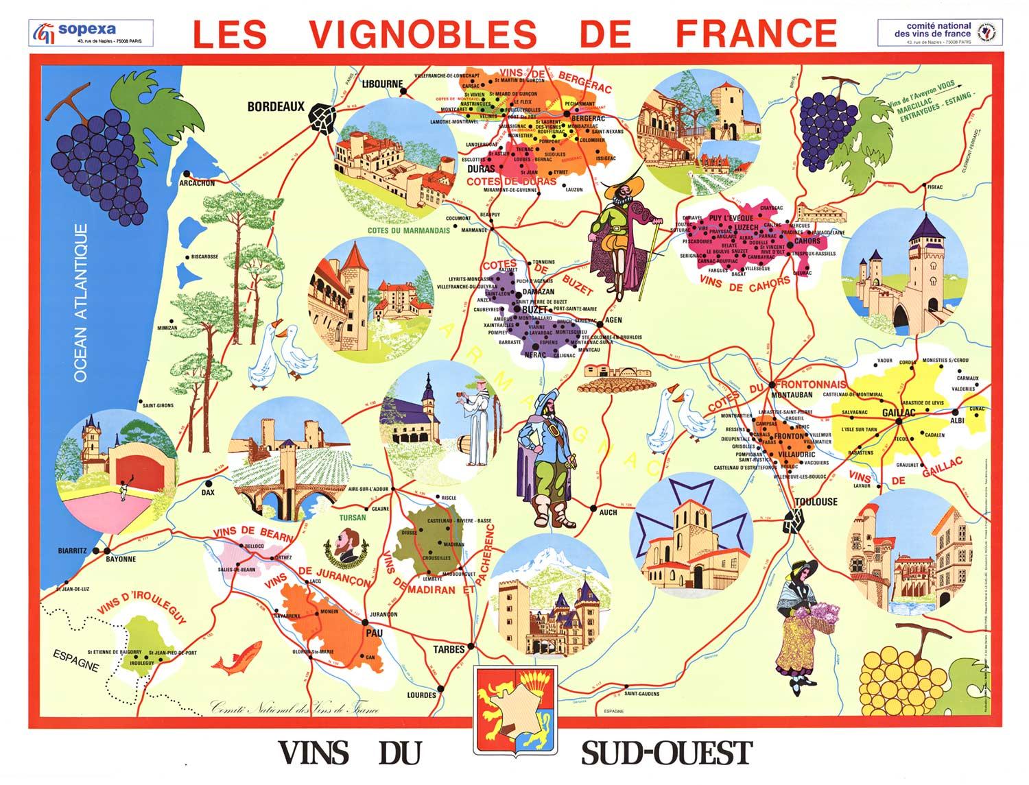
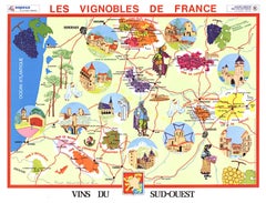
Original Vins du Sud-Ouest vintage French wine map poster
Located in Spokane, WA
Original Les Vignobles de France , Vins du Sud-Quest French vintage wine map poster. Horizontal. Size 36.5" x 27". Archival linen backed and re...
Category
Late 20th Century American Modern Landscape Prints
Materials
Lithograph
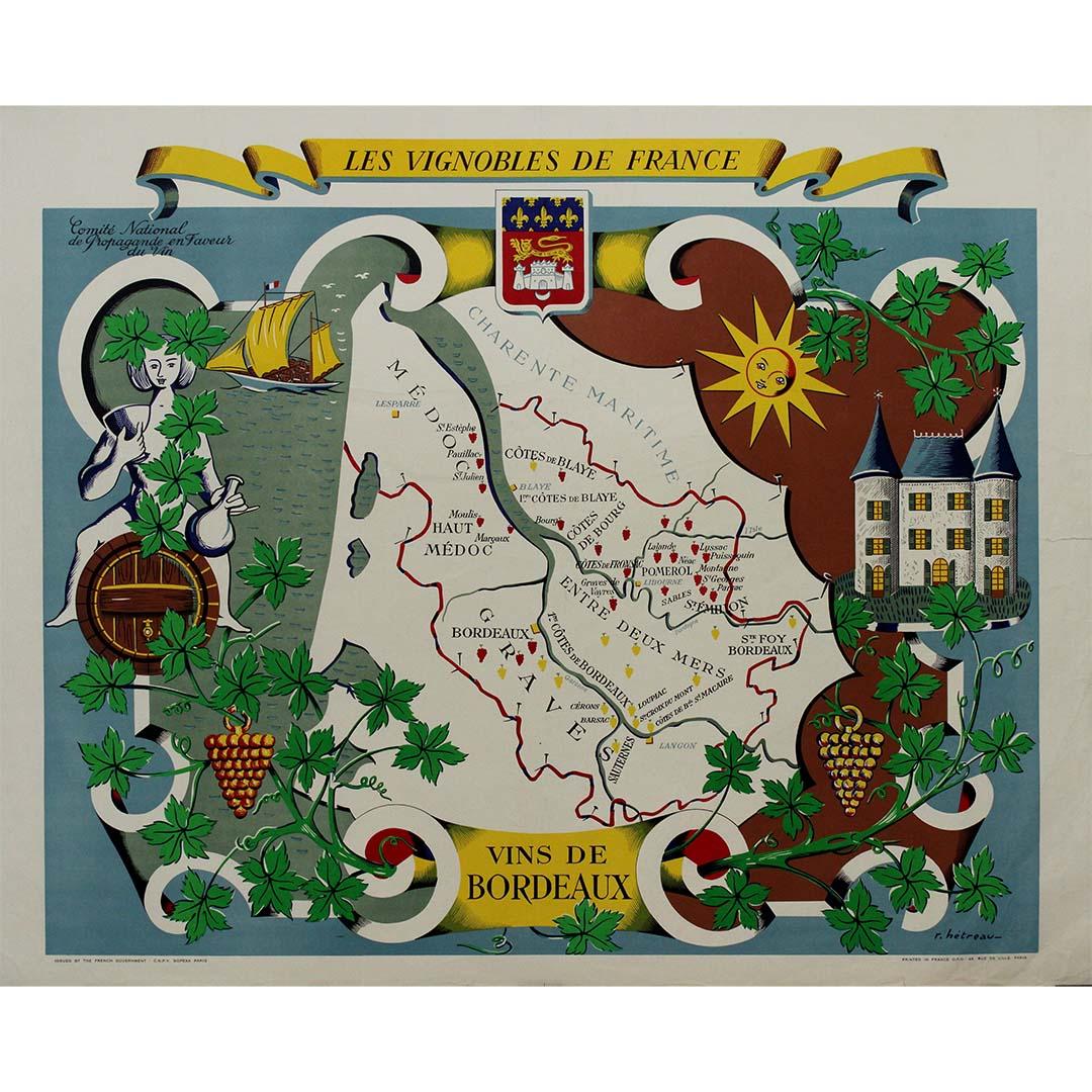
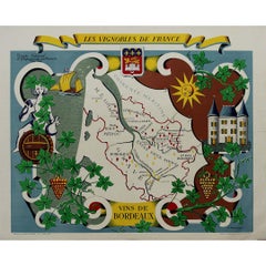
Stunning illustrated wine map by French artist Rémy Hétreau in the 1950s
Located in PARIS, FR
This stunning illustrated wine map, created by French artist Rémy Hétreau in the 1950s, is a beautifully detailed tribute to the legendary Bordeaux wine region. Commissioned by the Comité National de Propagande en Faveur du Vin, the poster is both an artistic masterpiece and an educational tool, showcasing the vineyards, terroirs, and appellations that define Bordeaux’s winemaking heritage.
At the center of the composition, a finely drawn map of Bordeaux highlights its most famous wine-growing areas, including:
🍷 Médoc – Home to prestigious wines from Pauillac, Margaux, and Saint-Estèphe.
🍷 Saint-Émilion & Pomerol – Renowned for their rich, elegant reds.
🍷 Graves & Sauternes – The birthplace of world-famous sweet wines.
🍷 Entre-Deux-Mers – Known for its crisp white wines.
Surrounding the map is a whimsical, decorative border featuring grapevines, a château, a sunlit vineyard, and a sailing ship, reflecting Bordeaux’s rich viticultural history and its connection to trade and maritime commerce. The Bordeaux coat of arms sits proudly at the top, reinforcing the region’s centuries-old winemaking tradition.
Rémy Hétreau (1913–2001), a celebrated French illustrator and designer, was known for his elegant, hand-drawn maps that brought the cultural and geographic identity of France to life. His work on this poster captures the romance, craftsmanship, and prestige of Bordeaux’s wine industry in a timeless mid-century style.
Today, this vintage wine map is highly sought after by collectors of French wine memorabilia...
Category
1950s Prints and Multiples
Materials
Paper, Lithograph
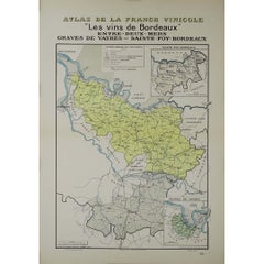
1941 original map "Les vins de Bordeaux - Entre-deux-mers, Graves... " by Larmat
Located in PARIS, FR
In 1941, French cartographer L. Larmat created a remarkable map titled Atlas de la France Vinicole: Les Vins de Bordeaux - Entre-Deux-Mers, Graves de Vayres, Sainte-Foy Bordeaux, whi...
Category
1940s Prints and Multiples
Materials
Lithograph, Paper
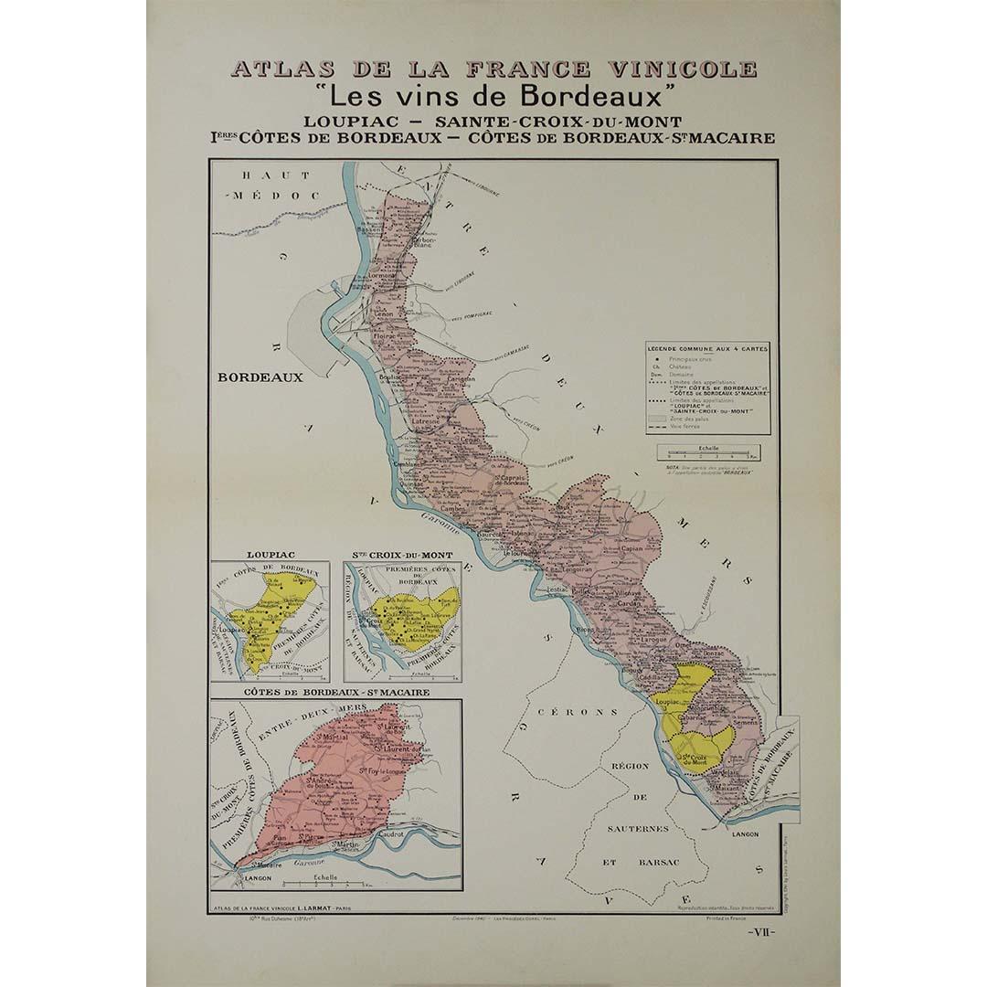
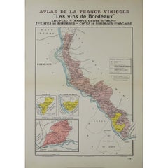
1941 original map "Les vins de Bordeaux - Loupiac, ..." by Larmat
Located in PARIS, FR
In 1941, L. Larmat crafted an exquisite map titled Atlas de la France Vinicole: Les Vins de Bordeaux - Loupiac, Sainte-Croix-du-Mont, Ières Côtes de Bordeaux, Côtes de Bordeaux St. M...
Category
1940s Prints and Multiples
Materials
Lithograph, Paper
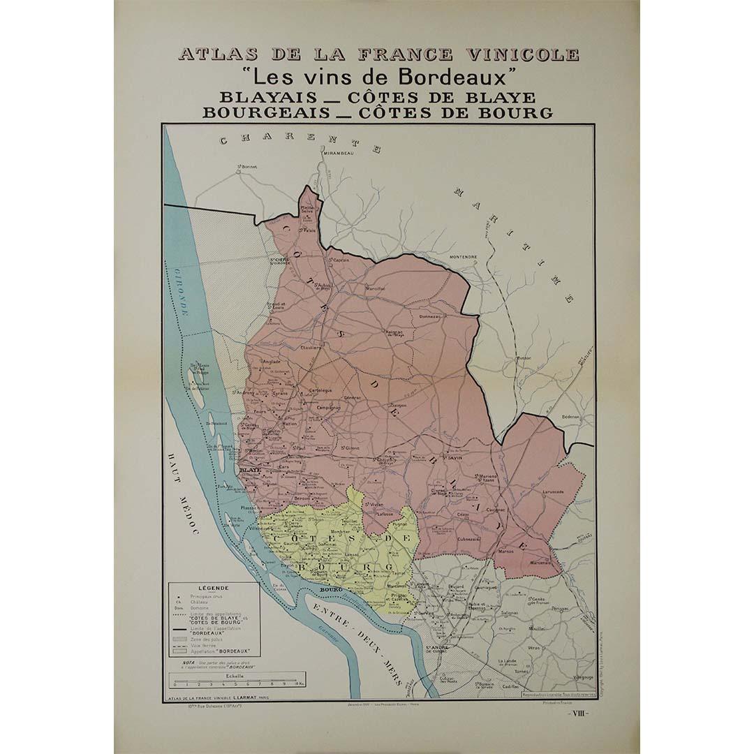
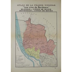
1941 original map "Les vins de Bordeaux - Blayais, Côtes de Blaye" by Larmat
Located in PARIS, FR
In 1941, L. Larmat created an impressive map titled Atlas de la France Vinicole: Les Vins de Bordeaux - Blayais, Côtes de Blaye, Bourgeais, Côtes de Bourg, printed by Dorel in Paris....
Category
1940s Prints and Multiples
Materials
Lithograph, Paper
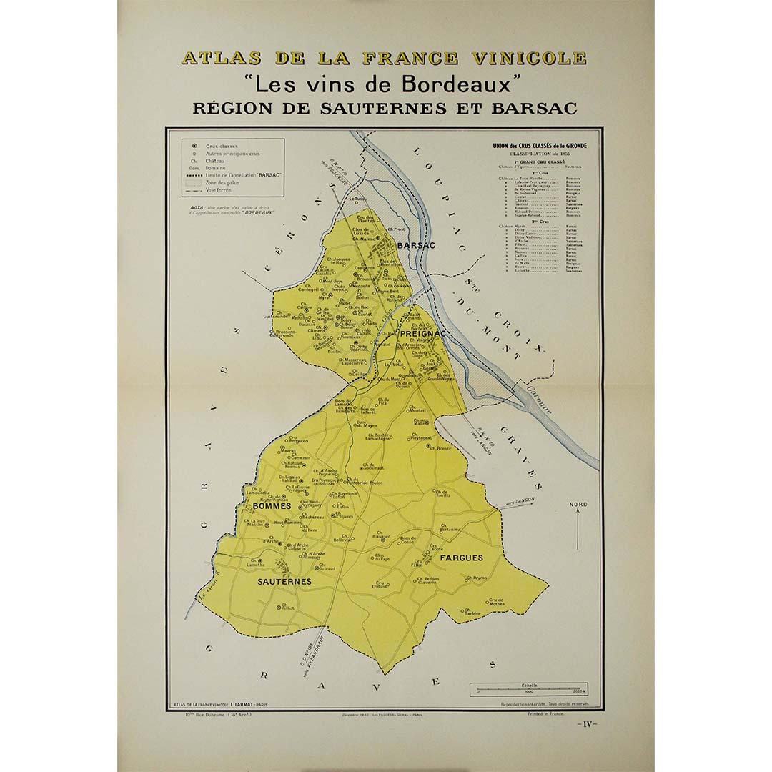
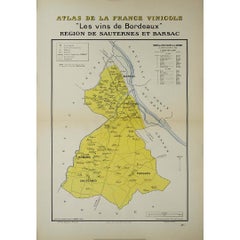
1941 original map "Les vins de Bordeaux - Régions de Sauternes" by Larmat
Located in PARIS, FR
The 1941 original map by L. Larmat, titled "Atlas de la France vinicole – Les vins de Bordeaux: Régions de Sauternes et Barsac", provides an intricate and precise depiction of two of...
Category
1940s Prints and Multiples
Materials
Lithograph, Paper
More Ways To Browse
Wine Map
Bordeaux Wine
Bordeaux Map
Thomas Hart Benton Original
1970 Calendar Print
Antique Prints New Orleans
Dollar Watch
Edgar Degas Bronze
Erte Signed Serigraph
Green Vintage Suitcase
J L Metz
Journal Des Dames Et Des Modes
Lenin Poster
Original Vintage Twa Posters
Picasso Bouquet
Picasso Dove Of Peace
Picasso Imaginaire 1969
Poster Vintage Suisse