Items Similar to Hand-Colored Map of Southern Italy, circa 1744

Want more images or videos?
Request additional images or videos from the seller
1 of 5
Matthew SeutterHand-Colored Map of Southern Italy, circa 1744circa 1744
circa 1744
$450
£338.28
€392.18
CA$628.27
A$703.70
CHF 366.16
MX$8,546.33
NOK 4,641.93
SEK 4,380.01
DKK 2,926.18
Shipping
Retrieving quote...The 1stDibs Promise:
Authenticity Guarantee,
Money-Back Guarantee,
24-Hour Cancellation
About the Item
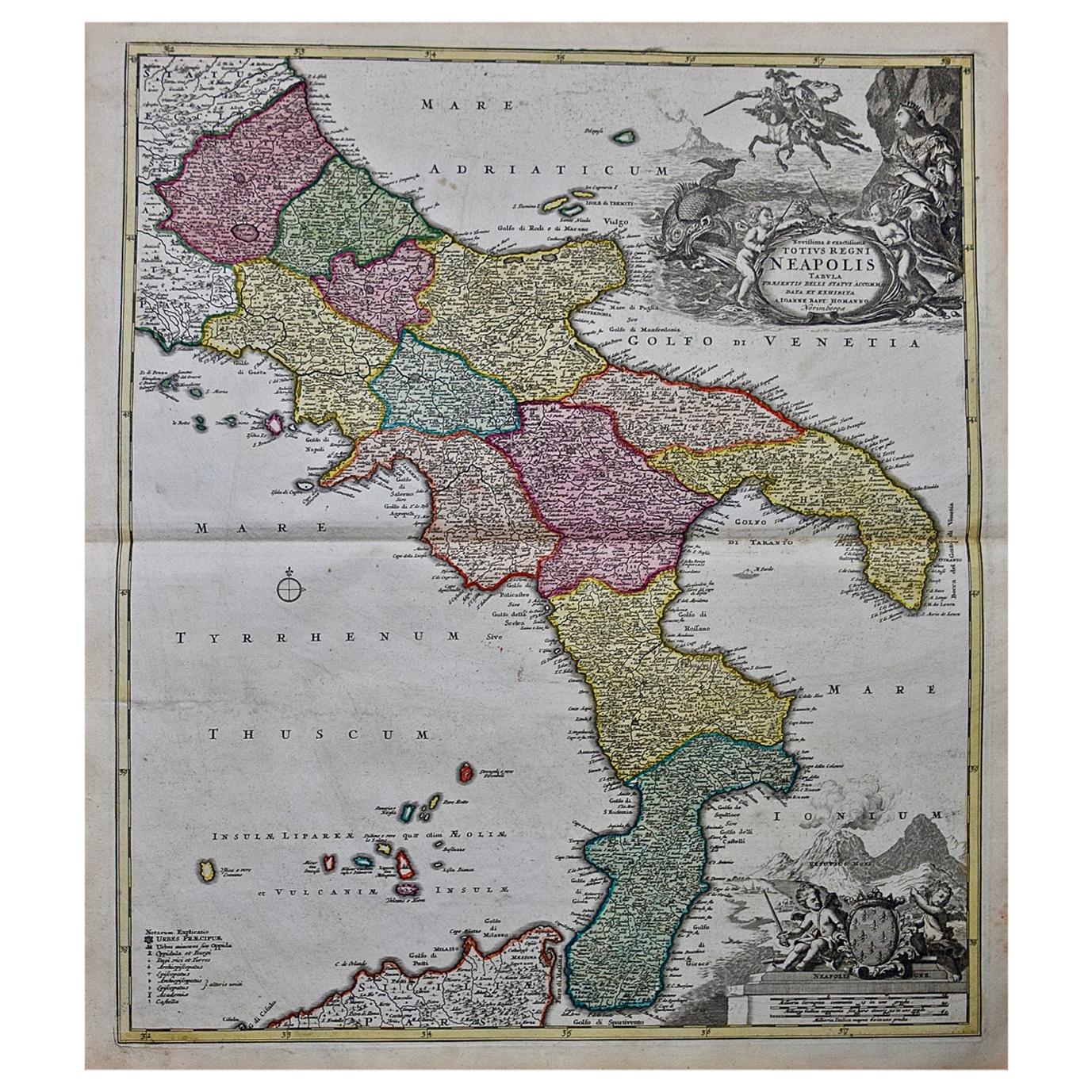
Seutter, Matthew.
Neapolis Regnum...
From Atlas minor praecipua Terrarum Imperia...
Augsburg, circa 1744.
Original engraving with old hand-coloring.
Image size: 10 3/16 x 7 11/16 inches.
- Creator:
- Creation Year:circa 1744
- Dimensions:Height: 16.5 in (41.91 cm)Width: 13.75 in (34.93 cm)Depth: 0.75 in (1.91 cm)
- Medium:
- Condition:
- Gallery Location:New York, NY
- Reference Number:Seller: 1579171stDibs: LU43831144913

About the Seller
4.9
Recognized Seller
These prestigious sellers are industry leaders and represent the highest echelon for item quality and design.
Established in 1972
1stDibs seller since 2016
185 sales on 1stDibs
Typical response time: <1 hour
Associations
International Fine Print Dealers Association
- ShippingRetrieving quote...Shipping from: New York, NY
- Return Policy
Authenticity Guarantee
In the unlikely event there’s an issue with an item’s authenticity, contact us within 1 year for a full refund. DetailsMoney-Back Guarantee
If your item is not as described, is damaged in transit, or does not arrive, contact us within 7 days for a full refund. Details24-Hour Cancellation
You have a 24-hour grace period in which to reconsider your purchase, with no questions asked.Vetted Professional Sellers
Our world-class sellers must adhere to strict standards for service and quality, maintaining the integrity of our listings.Price-Match Guarantee
If you find that a seller listed the same item for a lower price elsewhere, we’ll match it.Trusted Global Delivery
Our best-in-class carrier network provides specialized shipping options worldwide, including custom delivery.More From This Seller
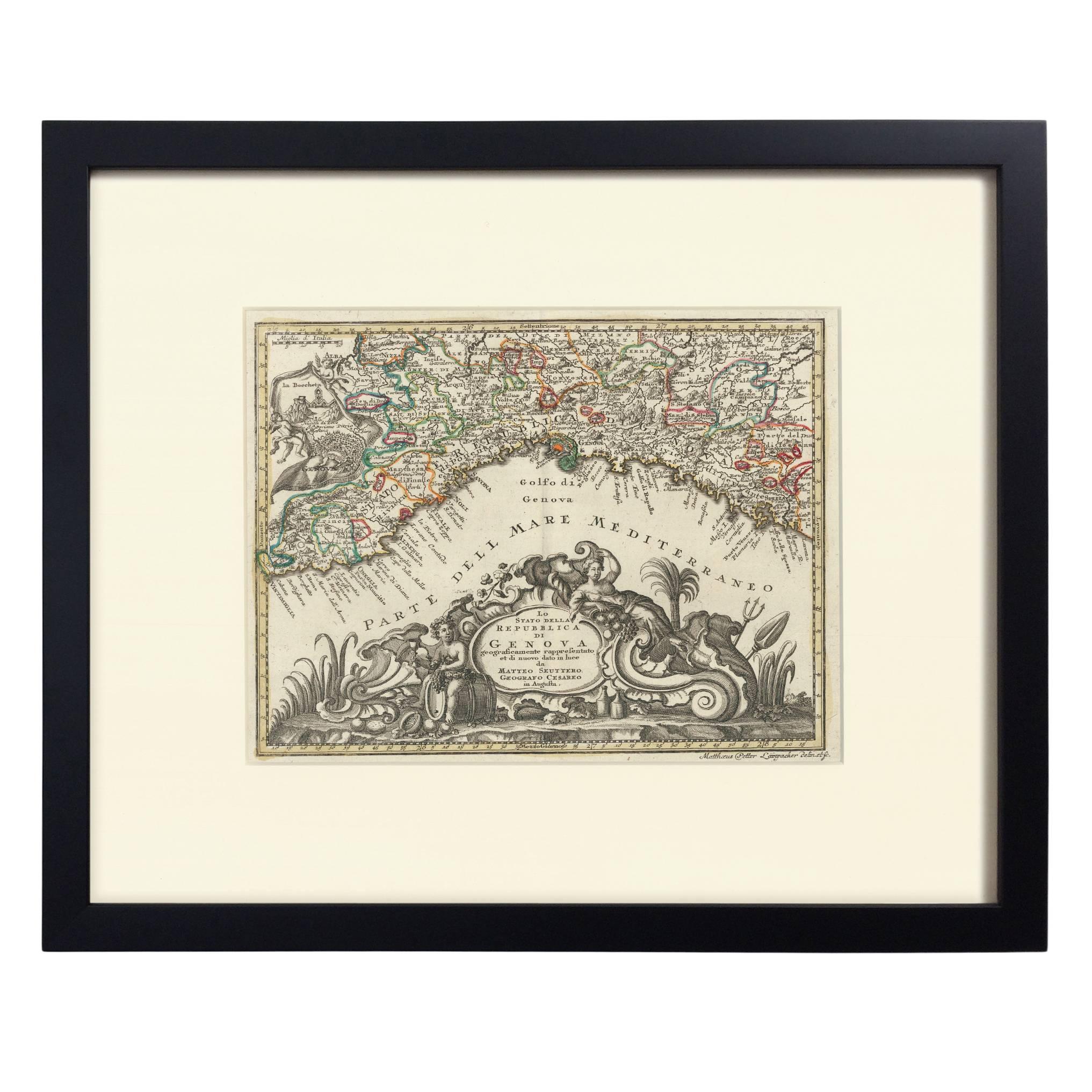
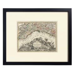
View AllHand-Colored Map of Genoa, circa 1744
By Matthew Seutter
Located in New York, NY
Seutter, Matthew.
Genova [Genoa].
From Atlas minor praecipua Terrarum Imperia...
Augsburg, circa 1744.
Original engraving with old hand-coloring.
Image size: 7 5/8 x 10 inches.
Materials
Paper
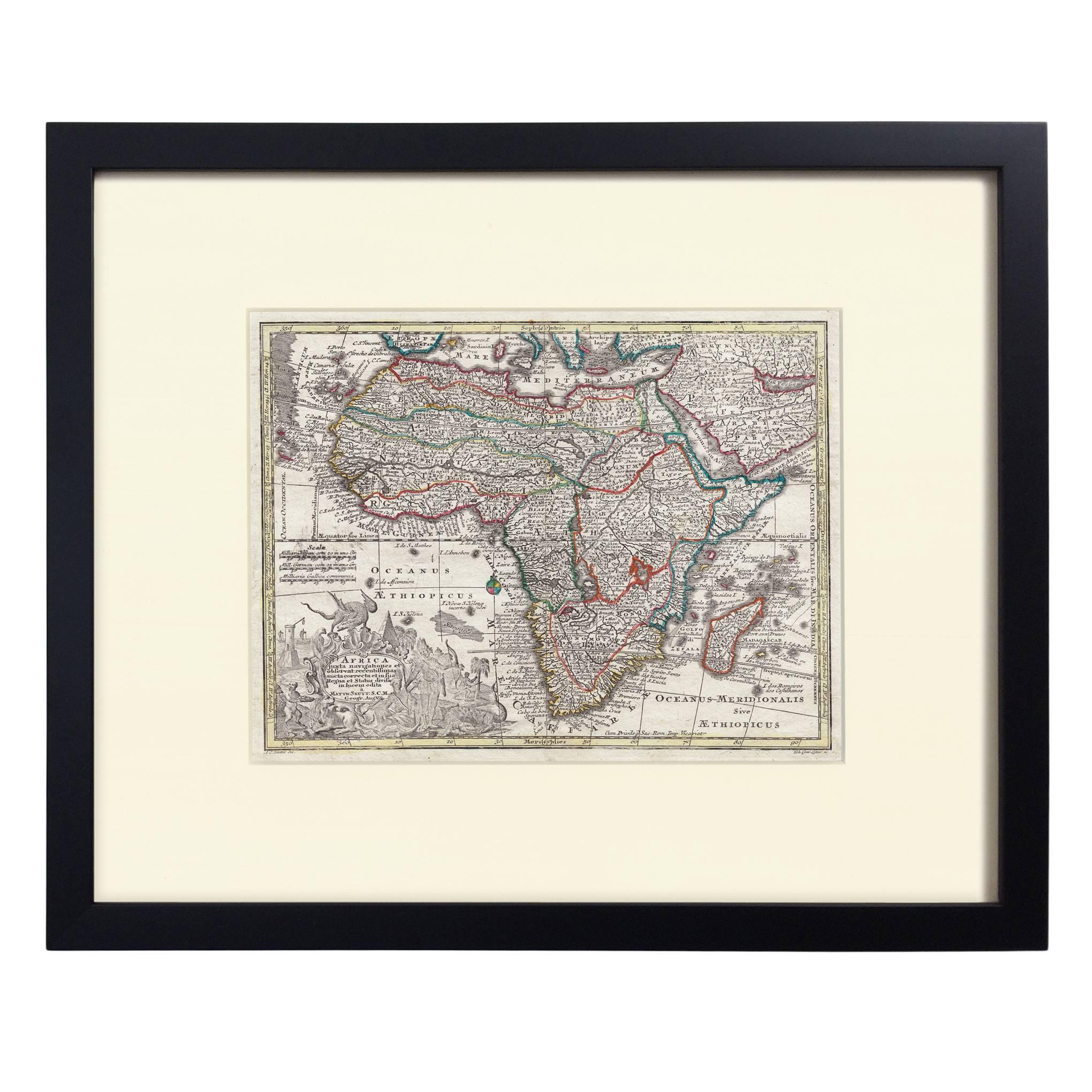
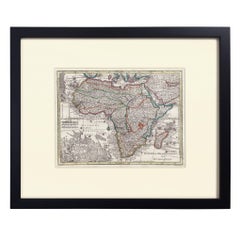
Hand-Colored Map of Africa, circa 1744
By Matthew Seutter
Located in New York, NY
Seutter, Matthew.
Africa.
From Atlas minor praecipua Terrarum Imperia...
Augsburg, circa 1744.
Original engraving with old hand-coloring.
Image size: 7 5/8 x 10 1/8 inches.
Materials
Paper
Two-Part Large Hand-Colored Map of Europe from 1798
By Thomas Kitchin
Located in New York, NY
Map of Europe printed on two separate sheets from A New Universal Atlas by Thomas Kitchin. Published in London by Laurie & Whittle, 1798. Original engravings hand-colored at publicat...
Category
1790s More Art
Materials
Paper

$1,700 Sale Price
33% Off
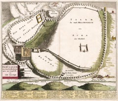
Map of Biblical Jerusalem
Located in New York, NY
Original copper engraving hand-colored at the time of publication. Nuremberg, 1720.
Category
1720s Prints and Multiples
Materials
Paper
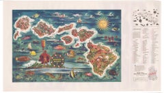
The Dole Map of the Hawaiian Islands.
Located in New York, NY
Original color lithograph. Honolulu. Hawaiian Pineapple Company, 1950.
Category
1950s Prints and Multiples
Materials
Paper
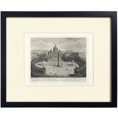
View of St. Peter's and the Vatican, 1867
By Giovanni Acquaroni
Located in New York, NY
Veduta della Basilica di S. Pietro in Vaticano... drawn and engraved by Giovanni Acquaroni. Copperplate engraving printed in Rome, 1867. Plate size: 7 3/8 x 9 1/4 in. In an archival ...
Category
Mid-19th Century Prints and Multiples
You May Also Like
Antique Map of Italy, Showing Corsica, Sardinia, Croatia, Malta and More, C.1740
Located in Langweer, NL
Antique map titled 'Nieuwe Kaart van Italie na de Nieuwste waarnemingen van de l'Isle en andere.'
Attractive detailed map showing Italy as well as Corsica, Sardinia, Minorca, Croat...
Category
Antique 18th Century Maps
Materials
Paper

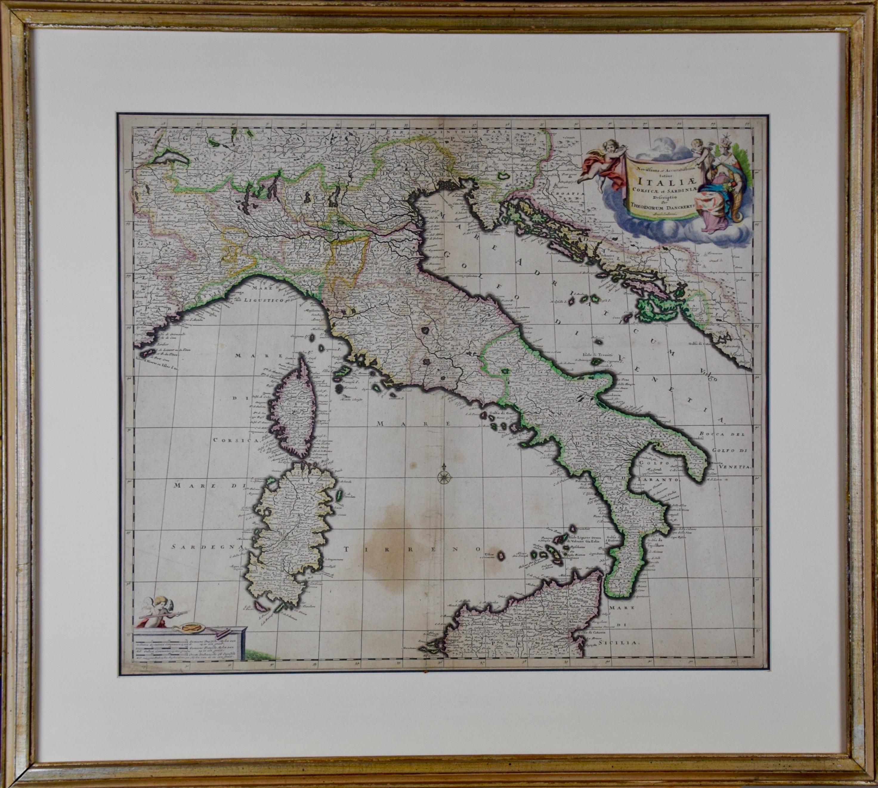
17th Century Dutch Map of Italy, Sicily, Sardinia, Corsica and Dalmatian Coast
By Theodorus Danckerts
Located in Alamo, CA
This hand colored 17th century Dutch map entitled "Novissima et Accuratissima totius Italiae Corsicae et Sardiniae Descriptio" by Theodore Danckerts depicts the Italian Peninsula in ...
Category
1690s Prints and Multiples
Materials
Engraving
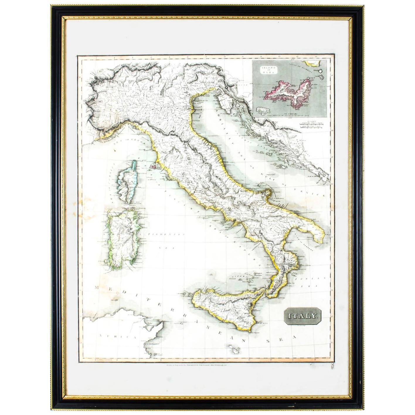
Antique Map of Italy Drawn & Engraved by R. Scott for Thomsons, Edinburgh 1814
Located in London, GB
This is a magnificent museum quality antique hand-coloured map of Italy, dating from 1814.
This historic and very rare antique map was drawn and engraved by R. Scott for Thomsons, New General Atlas, Edinburgh.
The map is very detailed and the various colours - yellow, grey and green - beautifully highlight the different natural and political divisions of Italy as it was before the Italian Unification...
Category
Antique 1810s Scottish Prints
Materials
Other

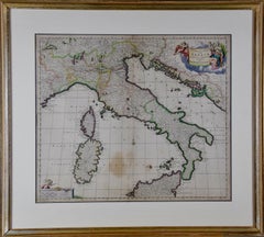
The Kingdom of Naples and Southern Italy: A Hand-Colored 18th Century Homann Map
By Johann Baptist Homann
Located in Alamo, CA
"Novissima & exactissimus Totius Regni Neapolis Tabula Presentis Belli Satui Accommo Data" is a hand colored map of southern Italy and the ancient Kingdom of Naples created by Johann...
Category
Antique Early 18th Century German Maps
Materials
Paper

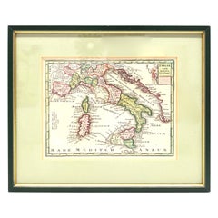
1970s Framed Antique Map of Italy 1746 Original
Located in Nuernberg, DE
An extraordinary original antique map, framed in the 1970s by Brehm Nuremberg, Germany, showing Italy. Map is dated 1746 and approx. 7 ¼" wide and 5 ¾" high in viewable size. Framed ...
Category
Vintage 1970s Decorative Art
Materials
Glass, Wood
Antique Map of Italy, Corsica, Sardinia and Sicily, ca.1780
Located in Langweer, NL
Description: Antique map titled 'L'Italie.'
Map of Italy, Corsica, Sardinia and Sicily. Highly detailed, showing towns, rivers, some topographical features and political boundari...
Category
Antique 1780s Maps
Materials
Paper

$305 Sale Price
20% Off
More Ways To Browse
Hand Colored Italian Engraving
Pop Art Super Heros
Vintage Joker
Chuck Jones
King Kong Sculpture
Oaxaca Textile
Cartoon Celluloid
Harley Vintage Art
Tweety Warner Bros
Pop Art Joker
Tweety Bird
Buster Brown
Walt Disney Production Drawing
Joker Painting
Vintage Devil Drawing
Tweety Bird Vintage
Art Specialty Company Chicago
Catherine Wheel