Carel Allard Art
Dutch, 1648-1709
Carel Allard was the son of Hugo Allard. He was a Dutch art dealer, cartographer and engraver. In the 17th-century, the Allard family published various maps in Amsterdam. Carel died in Amsterdam and was buried on February 1, 1709.
to
1
Overall Width
to
Overall Height
to
1
1
1
1
1
1
1
1
1
1
8,819
2,808
1,655
1,313
1
Artist: Carel Allard
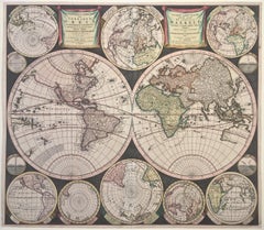
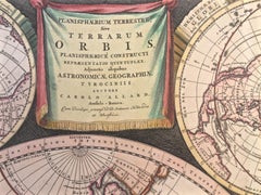
WORLD MAP - Planisphaerium Terrestre Sive Terrarum Orbis... 1696
By Carel Allard
Located in Santa Monica, CA
CAREL ALLARD (1648 – 1709)
PLANISPHAERIUM TERRESTRE SIVE TERRARUM ORBIS… 1696 (Shirley 578)
Engraving, 20 ½ x 23 ½”, sheet 21 x 24 1/8". A stunning double hemisphere World Map...
Category
17th Century Old Masters Carel Allard Art
Materials
Engraving
Related Items
Persia, Armenia & Adjacent Regions: A Hand-colored 17th Century Map by De Wit
By Frederick de Wit
Located in Alamo, CA
This colorful and detailed 17th century copperplate map by Frederick De Wit was published in Amsterdam between 1666 and 1690. It depicts the Caspian Se...
Category
Late 17th Century Old Masters Carel Allard Art
Materials
Engraving
$1,875
H 23.5 in W 27 in D 1.325 in
Christ Crowned with Thorns, from The Passion of Christ
By Hendrick Goltzius
Located in Middletown, NY
Engraving on cream wove paper, 8 x 5 3/8 inches (203 x 137 mm), narrow to thread margins. First state (of 2). A fine impression with archival paper adhered at left top and bottom cor...
Category
Early 17th Century Old Masters Carel Allard Art
Materials
Engraving
Ancient Roman Architecture: Original Framed 18th C. Etching by G. Piranesi
By Giovanni Battista Piranesi
Located in Alamo, CA
"Veduta del Sepolcro della Famiglia Plauzia per la Strada Che Conduce da Roma a Tivoli vicino a Ponte Lugano" from "Le Antichità Romane" (Roman Antiquities), one of the most famous works by Piranesi. "Antichita" illustrates the tombs along the Appian Way...
Category
Early 18th Century Old Masters Carel Allard Art
Materials
Etching, Engraving, Drypoint
$3,875
H 24.38 in W 31.75 in D 0.75 in
Frankfort, Germany: A 16th Century Hand-colored Map by Braun & Hogenberg
By Franz Hogenberg
Located in Alamo, CA
This is a 16th century original hand-colored copperplate engraved map of Frankfort, Germany entitled "Francenbergum, vel ut alij Francoburgum Hassiae Opp" by Georg Braun & Franz Hogenberg, from their famous city atlas "Civitates Orbis Terrarum", published in Cologne, Germany in 1595.
This is an English translation of an excerpt from the original text in the atlas:
"Frankenberg or, according to others, Francoburgum, a town in Hesse. Charlemagne vested the town of Frankenberg with many freedoms and privileges, which it still enjoys to this day, and on account of its valiant and victorious soldiers awarded a signet, upon which there formerly appeared a golden castle with a tower, together with the letter F and a golden crown.
Frankenberg, seen here from the northeast, lies on a hill above the River Eder. The hillside is covered with fields neatly separated by bushes and fences. Soaring above the town is the massive Liebfrauenkirche, which was modelled on St Elizabeth's church in Marburg. The New Town was founded in 1335 at the foot of the hill (right) and merged with the Old Town as late as 1556. Frankenberg was founded by Conrad of Thuringia in 1233/34 to prevent the archbishops of Mainz from expanding their sphere of influence...
Category
16th Century Old Masters Carel Allard Art
Materials
Engraving
$975
H 14.75 in W 21.75 in
Fountains of Rome
By Giovan Battista Falda
Located in Middletown, NY
A charming scene with romping dogs and spectators watching the cascading water play a trick on an unsuspecting man who is sprayed as he descends the steps, ...
Category
Early 17th Century Old Masters Carel Allard Art
Materials
Laid Paper, Engraving, Etching
Fountains of Rome; Fontana e castello dell'Acqua
By Giovan Battista Falda
Located in Middletown, NY
Rome: Giovanni Giacomo De Rossi, 1625.
Etching and engraving on cream laid paper, 8 3/8 x 11 1/4 inches (222 x 286 mm), full margins. In good condition with some light yellow discol...
Category
Early 17th Century Old Masters Carel Allard Art
Materials
Laid Paper, Engraving, Etching
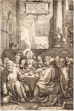
The Last Supper, from The Passion of Christ
By Hendrick Goltzius
Located in Middletown, NY
Engraving on cream laid paper, 8 x 5 3/8 inches (203 x 137 mm), trimmed at the platemark. A fine impression with a Coat of Arms watermark. Second state, after the addition of the Frederick de Witt...
Category
16th Century Old Masters Carel Allard Art
Materials
Engraving, Laid Paper
The Beheading of the King of England; Enthauptung des Königs in England
By Matthäus Merian the Elder
Located in Middletown, NY
The execution of Charles I (1600-1649) at Whitehall, January 30th 1649, in front of the Banqueting House. The executioner holding the head of Charles up to the crowd below.
Engravin...
Category
Mid-17th Century Old Masters Carel Allard Art
Materials
Engraving, Laid Paper
Column of Antoninus Pius, Rome Italy. Jacobs Lauro 17th century engraving
Located in Melbourne, Victoria
Lauro produced a series of engravings of the ancient monuments of Classical Rome with detailed descriptions in Latin below.
180mm by 240mm (plate mark)...
Category
Early 17th Century Old Masters Carel Allard Art
Materials
Engraving, Etching
$240
H 9.45 in W 13.59 in
Bermuda: An Early 17th Century Hand-colored Map by Henricus Hondius
By Henricus Hondius
Located in Alamo, CA
This attractive and interesting map of Bermuda by Henricus Hondius in 1633 is entitled "Mappa Aestivarum Insularum, Alias Barmudas". It is based on a ...
Category
Early 17th Century Old Masters Carel Allard Art
Materials
Engraving
$2,975
H 19 in W 22.38 in
Map of the World: An Original 18th Century Hand-colored Map by E. Bowen
Located in Alamo, CA
This is an original 18th century hand-colored map entitled "A New & Correct Chart of All The Known World Laid down according to Mercator's Projection" by Emanuel Bowen. It was published in 1744 in London in John Harris's "Navigantium atque Itinerantium Bibliotheca" or "A Complete Collection of Voyages and Travels". This highly detailed and colorful map depicts the world. as it was known in the mid 18th century. A majority of the northern and central portions of Canada and America are left blank due to the purity of knowledge at the time this map was published.
The map is embellished with four Compass Roses in the lower left, lower center, lower right and center, along with many rhumb lines. There a is a decorative title cartouche in the upper left. This colorful, attractive, historical and interesting 1744 map presents the entire world on Mercator's projection as it was understood in the middle part of the 18th century, before the landmark explorations of Captain’s Cook, Vancouver, Wilkes and others. It is an example of a nautical chart, a type of map that was designed specifically for use by mariners. The map is centered on the equator and includes both the Eastern and Western Hemispheres. The continents of North America, South America, Europe, Africa, and Asia are depicted, as well as various islands in the Atlantic, Pacific, and Indian Oceans. The map is laid out according to the Mercator projection, a type of cylindrical map projection that was developed in the 16th century by Flemish cartographer Gerardus Mercator. This projection has the advantage of preserving angles and shapes, making it useful for navigation. The map presents a paucity of inland detail, particularly for the Americas, but major cities, geographical landmarks, and regions are included. Ocean currents and Tradewinds are identified, as well as the magnetic declination lines or magnetic variance, which refers to the difference between true north and compass north. The continents are color coded, enhancing the beauty of this map. The three compass roses indicate the directions of the cardinal points.
The depiction of the western coast of America, the Pacific and Australia are interesting. There was very little exploration of Australia between the navigations of William Damper in 1699 and Tobias Furneaux in 1773. Most of the maps detail relies on the 17th century Dutch expeditions to Australia's western coast, by Abel Tasman and William Janszoon. Van Diemen's Land (Tasmania) and New Guinea appear connected to the Australian continent. New Zealand appears as a single landmass. North of New Zealand there is a landmass labelled 'Ter d' St. Esprit' which probably represents the New Hebrides Islands. This map precedes the accurate exploration of the South Pacific and east coast of Australia by Captain James Cook later in the 18th century. The map includes ‘Drakes' Port,' the site where Sir Francis Drake supposedly landed in 1579 during his 1579 circumnavigation of the globe. Here he claimed territory for England, restocked, and repaired his vessels. Drake named the region New Albion. The exact location of Drake's Port is a cartographic mystery. Drake's Harbor is believed to be in the region of San Francisco Bay, Bodega Bay, San Pablo Bay...
Category
Mid-18th Century Old Masters Carel Allard Art
Materials
Engraving
$1,275
H 15.75 in W 19.63 in
Le Tour de Clermont en Dauphine apartenant a Monsieur de Tonnerre
By Israel Silvestre
Located in Middletown, NY
Etching and engraving on handmade cream laid paper, 3 7/8 x 6 7/8 inches (97 x 173 mm), full margins. In good condition, consistent with age. Several small notations in pencil in t...
Category
18th Century Old Masters Carel Allard Art
Materials
Handmade Paper, Laid Paper, Engraving, Etching
$400
H 7.88 in W 6.88 in
Carel Allard art for sale on 1stDibs.
Find a wide variety of authentic Carel Allard art available for sale on 1stDibs. You can also browse by medium to find art by Carel Allard in engraving and more. Much of the original work by this artist or collective was created during the 18th century and earlier and is mostly associated with the Old Masters style. Not every interior allows for large Carel Allard art, so small editions measuring 24 inches across are available. Customers who are interested in this artist might also find the work of Adriaen van Ostade, Cornelis Bega, and Rembrandt van Rijn. Carel Allard art prices can differ depending upon medium, time period and other attributes. On 1stDibs, the price for these items starts at $4,750 and tops out at $4,750, while the average work can sell for $4,750.