Items Similar to 1621 Ptolemy & Magini Map of Taprobana (Sumatra) with Elephant Inset


Want more images or videos?
Request additional images or videos from the seller
1 of 10
1621 Ptolemy & Magini Map of Taprobana (Sumatra) with Elephant Inset
$735.19
£547.99
€620
CA$1,008.89
A$1,129.69
CHF 589.42
MX$13,764.47
NOK 7,479.28
SEK 7,110.81
DKK 4,720.45
Shipping
Retrieving quote...The 1stDibs Promise:
Authenticity Guarantee,
Money-Back Guarantee,
24-Hour Cancellation
About the Item
Title: 1620 Ptolemy and Magini Map of Taprobana (Sumatra) with Elephant Inset, Italian Edition
Description: This rare and beautifully hand-colored 1620 map engraving, Tavola Duodecima dell’Asia, originates from Giovanni Antonio Magini’s second Italian edition of Geographia by Claudius Ptolemaeus (Ptolemy), published in Padua by Paolo and Francesco Galignani between 1620 and 1621. The maps were engraved by Girolamo Porro, a leading Italian engraver known for his meticulous and detailed work, which greatly contributed to the Renaissance era’s cartographic advancements.
The map represents the island of Taprobana, an ancient name that has historically been associated with Sumatra or Sri Lanka. It follows the classical Ptolemaic style, rich with geographic annotations and textual descriptions. Taprobana was long considered a mysterious and significant landmass in early European geographical accounts, often exaggerated in size and importance. This map, adhering to Ptolemy’s theories, presents it as a large, detailed island surrounded by the Indian Ocean, labeled as Mare Indicum. The surrounding smaller islands are also illustrated, adding to the early European understanding of Southeast Asian geography.
A unique feature of this map is the decorative inset on the left side, which portrays an elephant standing beneath a tree. This illustration highlights the exotic fauna that European explorers and cartographers associated with the region. Below this image, an ornate cartouche contains a Latin inscription that references the wealth of the region, including mentions of gold, silver, gemstones, and various animals such as tigers and elephants. The textual notes at the bottom further elaborate on the natural riches of Taprobana, reflecting early European perceptions of Southeast Asia as a land abundant in resources and trade potential.
This copperplate engraving is a fine example of early 17th-century European mapmaking. The detailed linework and precise geographic depictions reflect the Renaissance fascination with Ptolemaic geography. Magini’s edition of Ptolemy’s Geographia played a crucial role in bridging classical knowledge with 17th-century cartographic advancements, influencing mapmakers of the time.
The paper of this engraving has a fine texture, characteristic of 17th-century Italian printmaking, and the original hand-coloring adds depth and vibrancy to the piece. This historical map is a valuable artifact, reflecting the intersection of classical geography, Renaissance scholarship, and European exploration.
Dimensions:
Approximately 7.5 x 11 inches (19 x 28 cm)
Artist and Cartographers:
Claudius Ptolemaeus (Ptolemy), Greek mathematician, astronomer, and geographer (circa 90 to 168 AD)
Giovanni Antonio Magini, Italian astronomer and cartographer (1555 to 1617)
Girolamo Porro, Italian engraver (circa 1520 to 1604)
Condition Report:
The paper remains strong and well-preserved, with visible chain lines indicative of 17th-century laid paper. The engraving lines are crisp and well-defined, showcasing the precision of Girolamo Porro’s work. The hand-coloring is original and has developed a pleasing patina that enhances the engraving’s aesthetic appeal. The margins are ample with minor toning consistent with age. The Latin and Italian inscriptions remain sharp and legible. There is some light age-toning, slight edge wear, and minor foxing spots, all typical for a print of this age. There are no significant tears, repairs, or damages. This map is in very good condition for its age and would make an excellent addition to any collection of early maps, Ptolemaic cartography, or Southeast Asian historical representations.
Framing Recommendations:
To preserve and enhance the presentation of this antique engraving, consider the following options.
Use museum-quality, acid-free mat board for archival matting and backing to prevent further aging and discoloration. A double mat with an inner accent in gold or ochre tones can complement the engraving’s warm hand-coloring.
Choose a classic wooden frame with a dark walnut or gilded finish to complement the historical aesthetic. A 17th-century-style frame with subtle carvings can enhance the antique character of the map.
Use UV-resistant museum glass or acrylic to prevent fading and protect against light exposure. Anti-reflective glass is recommended to ensure clarity while safeguarding the print.
For mounting, avoid adhesives that could damage the paper. Instead, use archival-quality corner mounts or Japanese paper hinges to secure the engraving without harming its integrity.
Display the framed engraving in a controlled environment away from direct sunlight and high humidity to preserve the vibrancy of the colors and the integrity of the paper. Ideal locations include a study, library, or gallery space where its historical significance can be fully appreciated.
This remarkable 1620 map of Taprobana by Ptolemy and Magini is a valuable historical artifact and an outstanding decorative piece, bringing together the beauty of Renaissance-era cartography and the legacy of classical geography.
- Dimensions:Height: 11.03 in (28 cm)Width: 7.49 in (19 cm)Depth: 0.01 in (0.2 mm)
- Materials and Techniques:Paper,Engraved
- Period:1620-1629
- Date of Manufacture:circa 1621
- Condition:Good. The paper remains strong and well-preserved, with visible chain lines indicative of 17th-century laid paper. The engraving lines are crisp and well-defined, showcasing the precision of Girolamo Porro’s work. The hand-coloring is original.
- Seller Location:Langweer, NL
- Reference Number:Seller: BGSH-0141stDibs: LU3054343931082
About the Seller
5.0
Recognized Seller
These prestigious sellers are industry leaders and represent the highest echelon for item quality and design.
Platinum Seller
Premium sellers with a 4.7+ rating and 24-hour response times
Established in 2009
1stDibs seller since 2017
2,493 sales on 1stDibs
Typical response time: <1 hour
- ShippingRetrieving quote...Shipping from: Langweer, Netherlands
- Return Policy
Authenticity Guarantee
In the unlikely event there’s an issue with an item’s authenticity, contact us within 1 year for a full refund. DetailsMoney-Back Guarantee
If your item is not as described, is damaged in transit, or does not arrive, contact us within 7 days for a full refund. Details24-Hour Cancellation
You have a 24-hour grace period in which to reconsider your purchase, with no questions asked.Vetted Professional Sellers
Our world-class sellers must adhere to strict standards for service and quality, maintaining the integrity of our listings.Price-Match Guarantee
If you find that a seller listed the same item for a lower price elsewhere, we’ll match it.Trusted Global Delivery
Our best-in-class carrier network provides specialized shipping options worldwide, including custom delivery.More From This Seller
View AllRare and Very Old Antique Map of South East Asia, Published circa 1574
Located in Langweer, NL
A very fine impression of this map of the Malay Peninsula, Sumatra, Java, with Singapore denoted as 'Cinca Pula'.
Highly distorted and inaccurate map by Girolamo Ruscelli after J...
Category
Antique 16th Century Maps
Materials
Paper

$1,138 Sale Price
20% Off
Free Shipping
Old Antique Map of the East Indies and Southeast Asia, ca.1644
Located in Langweer, NL
Antique map titled 'India quae Orientalis dicitur, et Insulae adiacentes'.
Old map of the East Indies and Southeast Asia showing the area between India in the West and parts of Japan, the Marianas and New Guinea/Australia in the East. This map is dedicated to D. Christophorus Thisius by Henricus...
Category
Antique 1640s Maps
Materials
Paper

$2,513 Sale Price
20% Off
Antique Map of Java by Janssonius, circa 1650
Located in Langweer, NL
Antique map titled 'Insulae Iavae cum parte insularum Borneo Sumatrae, et circumjacentium insularum novissima delineatio'. Beautiful map of Java and parts of Bali, Borneo, Sumatra an...
Category
Antique Mid-17th Century Maps
Materials
Paper

Antique Map of Java in The Dutch East Indies, Now Indonesia, c.1690
Located in Langweer, NL
Antique map titled 'Insulae Iavae cum parte insularum Boreno Sumatrae (..)'.
Beautiful map of the Island of Java and part of Borneo, Bali, Madura and Sumatra. Artists and Engrave...
Category
Antique 17th Century Maps
Materials
Paper

$2,608 Sale Price
20% Off
Antique Map of the Sunda Islands Including Sumatra, Java, and Borneo, 1705
Located in Langweer, NL
Title: “Antique Map of the Sunda Islands Including Sumatra, Java, and Borneo”
This print is a beautifully detailed and relatively rare map of Western Indonesia, encompassing the reg...
Category
Antique Early 1700s Maps
Materials
Paper

$815 Sale Price
20% Off
Free Shipping
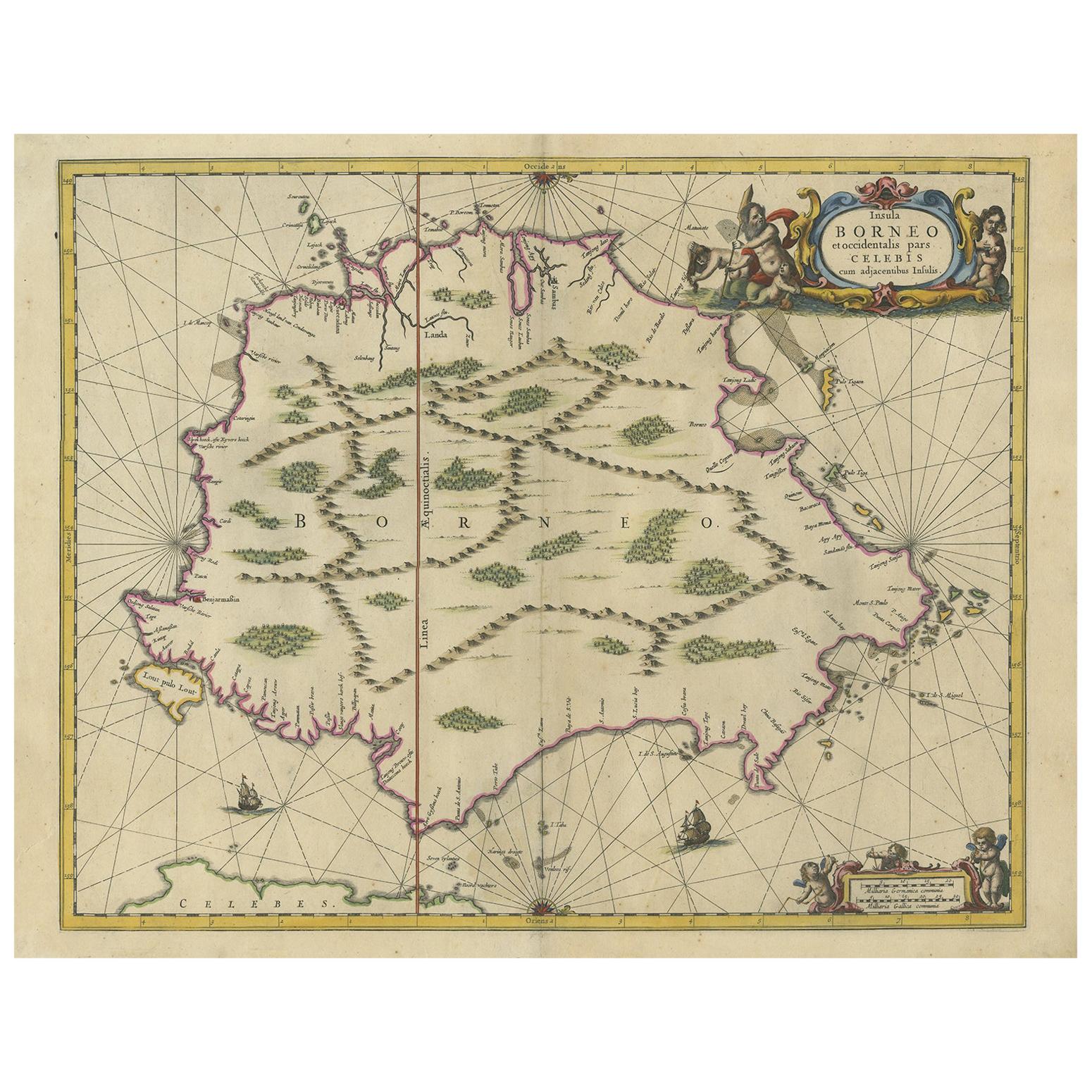
Antique Map of the Island of Borneo by Janssonius, circa 1650
Located in Langweer, NL
Antique map titled 'Insula Borneo et Occidentalis pars Celebis cum adjacentibus Insulis'. Rare sea chart of the island of Borneo. Published by J. Janssonius, circa 1650.
Category
Antique Mid-17th Century Maps
Materials
Paper

$1,749 Sale Price
24% Off
You May Also Like
1640 Willem Blaeu Map Entitled "Contado di molise et principato vltra, " Ric.a003
By Willem Blaeu
Located in Norton, MA
1640 Willem Blaeu map entitled
"Contado di molise et principato vltra,"
Colored
Ric. a003
Measures: 38 x 49.6 cm and wide margins
DBLAEU.
Cou...
Category
Antique 17th Century Dutch Maps
Materials
Paper

Engraving Depicting 16th Century Map of Terra Sancta
Located in Buchanan, MI
Abraham Ortelius (Flemish, 1527-1598) Terra Sancta.
Engraving depicting 16th century map of Terra Sancta. Site 15" x 19.5.
Category
Antique 18th Century and Earlier Maps
Materials
Paper

1592 Abraham Ortelius Map "Lorraine: Lotharingiae Nova Descripti, Ric.A005
Located in Norton, MA
1592 Abraham Ortelius map entitled
"Lorraine: Lotharingiae Nova Descripti
Ric.a005
Description: Ortelius is best known for producing the atlas from which this map comes from, "...
Category
Antique 16th Century Dutch Maps
Materials
Paper

Antique 1803 Italian Map of Asia Including China Indoneseia India
Located in Amsterdam, Noord Holland
Antique 1803 Italian Map of Asia Including China Indoneseia India
Very nice map of Asia. 1803.
Additional information:
Type: Map
Country of Manufacturing: Europe
Period: 19th centu...
Category
Antique 19th Century European Maps
Materials
Paper

$584 Sale Price
20% Off
1571-1638 Willem Blaeu map entitled, "Ilcadorino, " Hand Colored Ric0009
Located in Norton, MA
Willem Blaeu map entitled,
"Ilcadorino,".
Hand colored.
Description: large, unusual, and nice antique copper engraved map of Ilcadorino, by Willem BL...
Category
Antique 16th Century Dutch Maps
Materials
Paper

1633 Map Entitled "Beauvaisis Comitatus Belova Cium, Ric.0002
Located in Norton, MA
1633 map entitled
"Beauvaisis Comitatus Belova Cium,"
Hand Colored
Ric.0002
Description: Cartographer : - Hondius, Henricus 1587-1638
Artists and Engravers:Jodocus Hondius, one of the most notable engravers of his time. He is known for his work in association with many of the cartographers and publishers prominent at the end of the sixteenth and the beginning of the seventeenth century. A native of Flanders, he grew up in Ghent, apprenticed as an instrument and globe maker and map engraver. In 1584, to escape the religious troubles sweeping the Low Countries at that time, he fled to London where he spent some years before finally settling in Amsterdam about 1593. In the London period he came into contact with the leading scientists and geographers of the day and engraved maps in The Mariner\\\\\\\\\\\\\\\'s Mirrour, the English edition of Waghenaer\\\\\\\\\\\\\\\'s Sea Atlas, as well as others with Pieter van den Keere, his brother-in-law. No doubt his temporary exile in London stood him in good stead, earning him an international reputation, for it could have been no accident that Speed chose Hondius to engrave the plates for the maps in The Theatre of the Empire of Great Britaine in the years between 1605 and 1610. In 1604 Hondius bought the plates of Mercator\\\\\\\\\\\\\\\'s Atlas which, in spite of its excellence, had not competed successfully with the continuing demand for the Ortelius Theatrum Orbis Terrarum. To meet this competition Hondius added about 40 maps to Mercator\\\\\\\\\\\\\\\'s original number and from 1606 published enlarged editions in many languages, still under Mercator\\\\\\\\\\\\\\\'s name but with his own name as publisher. These atlases have become known as the Mercator/Hondius series. The following year the maps were reengraved in miniature form and issued as a pocket Atlas Minor. After the death of Jodocus Hondius the Elder in 1612, work on the two atlases, folio and miniature, was carried on by his widow and sons, Jodocus II and Henricus, and eventually in conjunction with Jan Jansson in Amsterdam.
In all, from 1606 onwards, nearly 50 editions with increasing numbers of maps with texts in the main European languages were printed. Summaries of these issues are given under the entry for Gerard Mercator. Jodocus Hondius the Elder * 1588 Maps in The Mariner\\\\\\\\\\\\\\\'s Mirrour (Waghenaer/Ashley) * 1590 World Map...
Category
Antique 17th Century Dutch Maps
Materials
Paper

More Ways To Browse
Antique Glass Elephant
Tiger Carving
Inset Gemstone
Porro Italy
Antique Indian Silver Elephant
Vintage Scandanavian Chairs
19th Century Red Glass
Antique French Console Table Tables
Silver Bowl Large
Antique French Silk
Down Couch
Used Lighter Art
Blue Edge Glass
Mahogany 1950s Furniture
Solid Mahogany Table
Dessert Glasses
Geometric Glass Table
Mid Century Pin