Items Similar to 1684 Mallet Map of Amazon River & Kingdom of Amazons – Hand Colored, Miniature

Want more images or videos?
Request additional images or videos from the seller
1 of 9
1684 Mallet Map of Amazon River & Kingdom of Amazons – Hand Colored, Miniature
$421.75
$527.1820% Off
£313.90
£392.3820% Off
€352
€44020% Off
CA$577.69
CA$722.1120% Off
A$642.51
A$803.1420% Off
CHF 335.50
CHF 419.3820% Off
MX$7,818.72
MX$9,773.4020% Off
NOK 4,284.86
NOK 5,356.0820% Off
SEK 4,018.44
SEK 5,023.0520% Off
DKK 2,679.65
DKK 3,349.5720% Off
Shipping
Retrieving quote...The 1stDibs Promise:
Authenticity Guarantee,
Money-Back Guarantee,
24-Hour Cancellation
About the Item
This map, titled 'Royaume des Amazones', was created by Alain Manesson Mallet and published in 1684 in a German edition of *Beschreibung des Gantzen Welt-Kreisses*, a renowned work derived from his famous 'Description de l'Univers.
This beautifully hand-colored miniature map depicts northern South America, with a special focus on the Amazon River and the legendary Kingdom of the Amazons.
Key Features:
- Depiction of the Amazon River: The map shows the northern portion of South America, with the Amazon River prominently displayed along with its surrounding regions.
- Decorative elements: The map is held up by two allegorical figures of native Amazonians, one holding a bow and the other a spear. These figures personify the myth of the Amazons, a race of warrior women believed to inhabit the region.
- The map includes several historical and mythical locations, such as Castille d'Or, Pays des Tapouyes, Guiana, Caribana, and the Royaume des Amalone, the "Kingdom of the Amazons."
- Hand coloring enhances the decorative and geographical features of the map, making it not only informative but also visually striking.
Size: This is a miniature map, typical of Mallet’s publications, though the exact dimensions would need to be confirmed.
This map is a valuable piece for collectors of mythical maps, South American cartography, or 17th-century miniatures. It’s a perfect example of the fascination with both the geographic and legendary aspects of the Amazon during the era of exploration.
Keywords: Alain Manesson Mallet, 1684 map, Royaume des Amazones, Amazon River, South America, mythical maps, Amazon legend, antique map, hand-colored map, miniature map, native Amazonians, cartography, Pays des Tapouyes, Guiana, Castille d'Or, rare maps, 17th-century maps, Description de l'Univers, German edition, exploration maps.
- Dimensions:Height: 5.79 in (14.7 cm)Width: 4.02 in (10.2 cm)Depth: 0 in (0.02 mm)
- Materials and Techniques:Paper,Engraved
- Period:1680-1689
- Date of Manufacture:1684
- Condition:Condition is good. A dark impression on a sheet with the watermark of three circles and minor marginal soiling.
- Seller Location:Langweer, NL
- Reference Number:1stDibs: LU3054341860502
About the Seller
5.0
Recognized Seller
These prestigious sellers are industry leaders and represent the highest echelon for item quality and design.
Platinum Seller
Premium sellers with a 4.7+ rating and 24-hour response times
Established in 2009
1stDibs seller since 2017
2,502 sales on 1stDibs
Typical response time: <1 hour
- ShippingRetrieving quote...Shipping from: Langweer, Netherlands
- Return Policy
Authenticity Guarantee
In the unlikely event there’s an issue with an item’s authenticity, contact us within 1 year for a full refund. DetailsMoney-Back Guarantee
If your item is not as described, is damaged in transit, or does not arrive, contact us within 7 days for a full refund. Details24-Hour Cancellation
You have a 24-hour grace period in which to reconsider your purchase, with no questions asked.Vetted Professional Sellers
Our world-class sellers must adhere to strict standards for service and quality, maintaining the integrity of our listings.Price-Match Guarantee
If you find that a seller listed the same item for a lower price elsewhere, we’ll match it.Trusted Global Delivery
Our best-in-class carrier network provides specialized shipping options worldwide, including custom delivery.More From This Seller
View AllAntique Map of the Course of the Amazon River by E. Van Harrevelt, 1773
Located in Langweer, NL
Detailed regional map, showing the course of the Amazon River from the Andes to the Atlantic. This map originates from 'Atlas portatif pour servir à l'intelligence de l'histoire phil...
Category
Antique Late 18th Century Maps
Materials
Paper
$330 Sale Price
20% Off
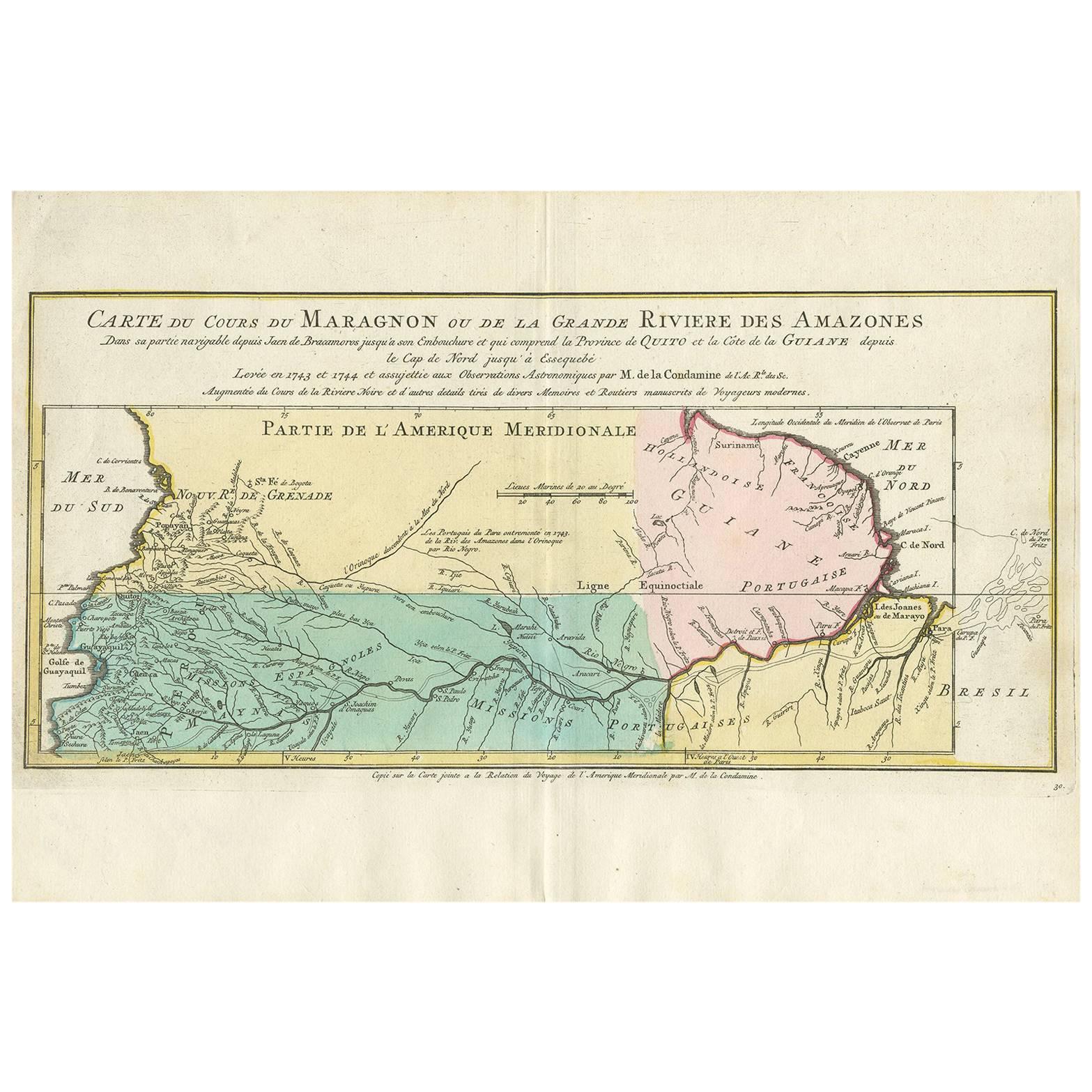
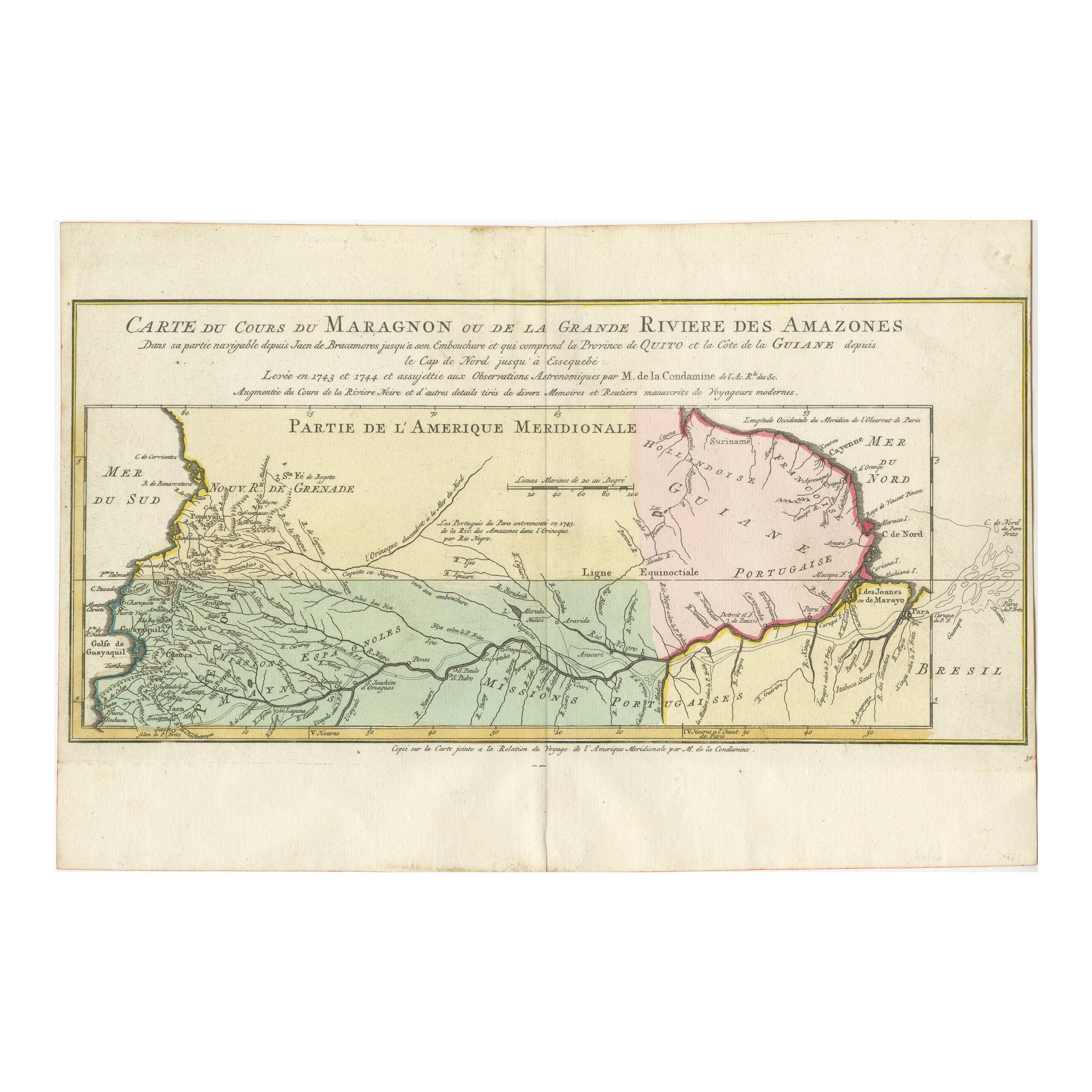
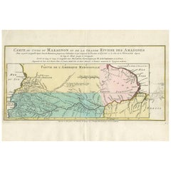
Map of the Amazon River's Course and Surrounding Regions (1743-1744)
Located in Langweer, NL
This original antique map, titled "Carte du Cours du Maragnon ou de la Grande Riviere des Amazones," illustrates the course of the Amazon River (referred to here as the Maragnon) fro...
Category
Antique 1750s Maps
Materials
Paper

$373 Sale Price
29% Off
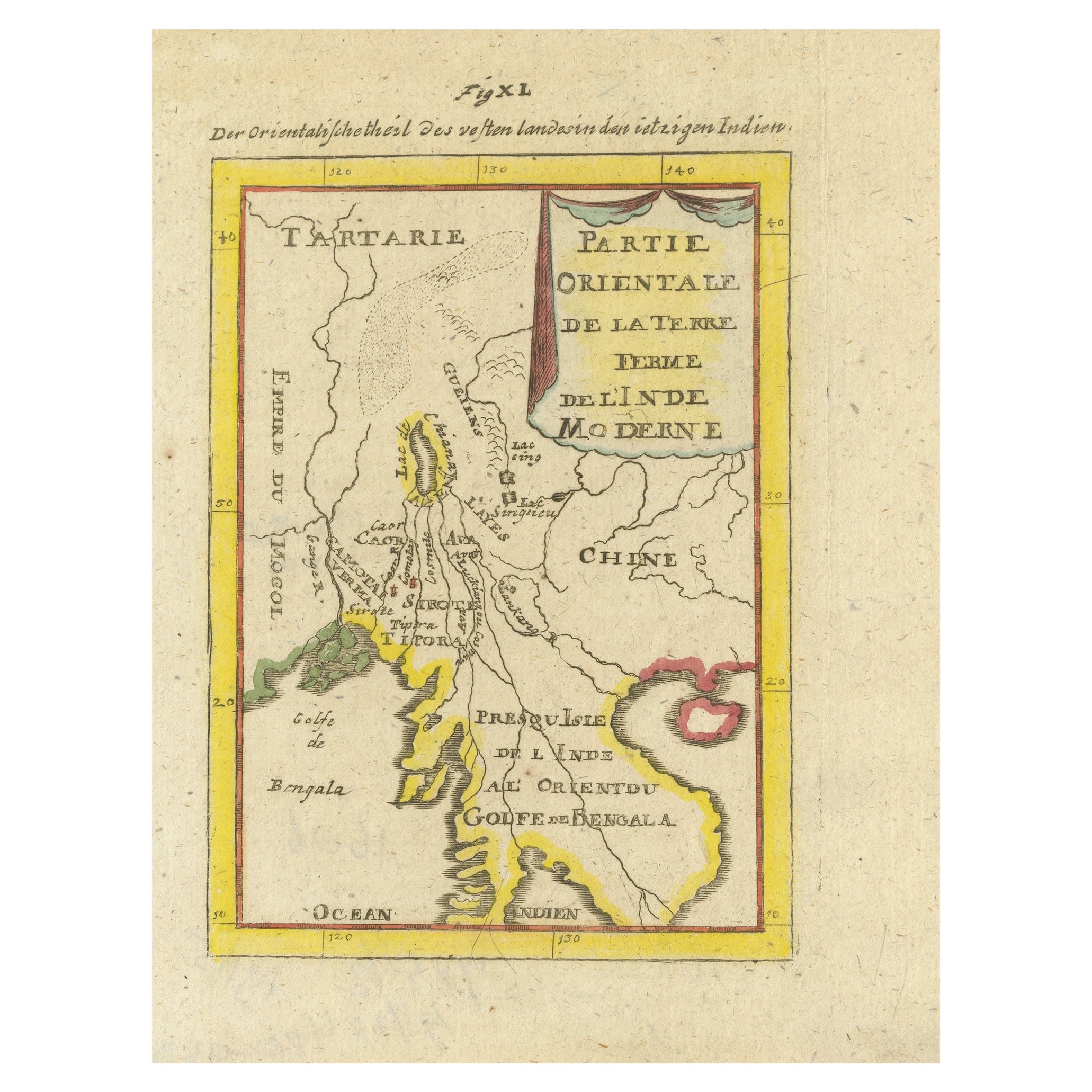
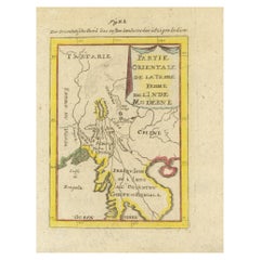
Antique Map of India and the Gulf of Bengal by Mallet, c.1686
Located in Langweer, NL
Antique map titled ?Partie Orientale de la Terre Ferme de l'Inde Moderne. Small map of India and the Gulf of Bengal. This map originates from a German edition of 'Description de l' Univers'.
Artists and Engravers: Alain Manesson Mallet (1630-1706) was a French cartographer and engineer. He started his career as a soldier in the army of Louis XIV, became a Sergeant-Major in the artillery and an Inspector of Fortifications. He also served under the King of Portugal, before returning to France, and his appointment to the court of Louis XIV. His military engineering and mathematical background led to his position teaching mathematics at court. His 'Description de L'Universe' contains a wide variety of information, including star maps...
Category
Antique 17th Century Maps
Materials
Paper
$335 Sale Price
20% Off
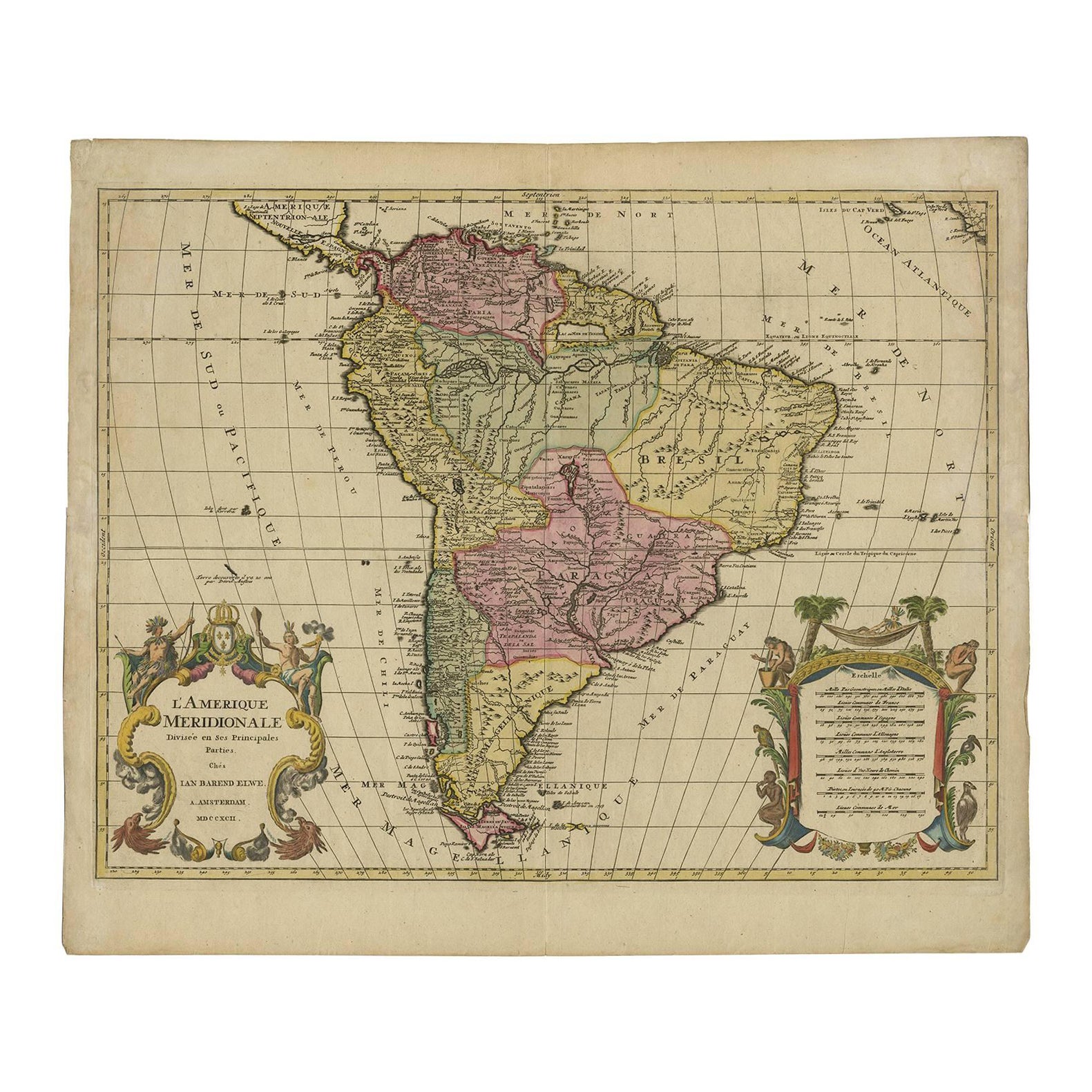
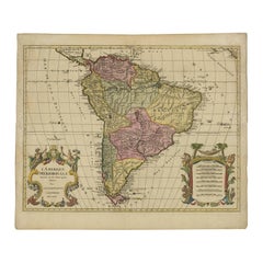
Map of South America 1792 by Elwe – Hand-Colored Antique Dutch Engraving
By J.B. Elwe
Located in Langweer, NL
Map of South America 1792 by Elwe – Hand-Colored Antique Dutch Engraving
This striking antique map of South America, titled "L'Amerique Meridionale," was published in 1792 by the Du...
Category
Antique Late 18th Century European Maps
Materials
Paper
Antique Map of South America by J. Cook, 1775
Located in Langweer, NL
Antique map titled 'Kaart van het Zuidlyk Eind van Amerika'. Map of the sourthern part of South America, focusing on Cook's tracks around the Cape Horn and T...
Category
Antique Mid-18th Century Maps
Materials
Paper

$814 Sale Price
20% Off
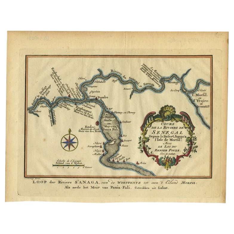
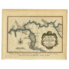
Antique Map of the Course of the Sanaga River by Van Schley, 1747
Located in Langweer, NL
Antique map titled 'Cours de la Riviere de Senegal (..) - Loop der Riviere Sanaga (..)'. Original antique map of the course of the Sanaga River that forms the border between Senegal ...
Category
Antique 18th Century Maps
Materials
Paper
$122 Sale Price
20% Off
You May Also Like
North & South America: A 17th Century Hand-colored Map by Jansson & Goos
By Johannes Janssonius
Located in Alamo, CA
A 17th century hand-colored map of North & South America entitled "Americae Descriptio" by the cartographer Johannes Jansson, published in Jansson's Atlas Minor in Amsterdam in 1628....
Category
Antique 1620s Dutch Maps
Materials
Paper

"Nova Barbariae Descriptio", a 17th Century Hand-Colored Map of North Africa
By Johannes Janssonius
Located in Alamo, CA
This original attractive 17th century hand-colored map of North Africa entitled "Nova Barbariae Descriptio" by Johannes Janssonius was published in Paris in 1635. It includes the Med...
Category
Antique Mid-17th Century Dutch Maps
Materials
Paper

"Africa Vetus": a 17th Century Hand-Colored Map by Sanson
By Nicolas Sanson
Located in Alamo, CA
This original hand-colored copperplate engraved map of Africa entitled "Africa Vetus, Nicolai Sanson Christianiss Galliar Regis Geographi" was originally created by Nicholas Sanson d...
Category
Antique Late 17th Century French Maps
Materials
Paper

Original Antique Map of South America. C.1780
Located in St Annes, Lancashire
Great map of South America
Copper-plate engraving
Published C.1780
Two small worm holes to left side of map
Unframed.
Category
Antique Early 1800s English Georgian Maps
Materials
Paper

California, Alaska and Mexico: 18th Century Hand-Colored Map by de Vaugondy
By Didier Robert de Vaugondy
Located in Alamo, CA
This is an 18th century hand-colored map of the western portions of North America entitled "Carte de la Californie et des Pays Nord-Ouest separés de l'Asie par le détroit d'Anian, ex...
Category
Antique 1770s French Maps
Materials
Paper

17th Century Hand Colored Map of the Liege Region in Belgium by Visscher
By Nicolaes Visscher II
Located in Alamo, CA
An original 17th century map entitled "Leodiensis Episcopatus in omnes Subjacentes Provincias distincté divisusVisscher, Leodiensis Episcopatus" by Nicolaes Visscher II, published in Amsterdam in 1688. The map is centered on Liege, Belgium, includes the area between Antwerp, Turnhout, Roermond, Cologne, Trier and Dinant.
This attractive map is presented in a cream-colored mat measuring 30" wide x 27.5" high. There is a central fold, as issued. There is minimal spotting in the upper margin and a tiny spot in the right lower margin, which are under the mat. The map is otherwise in excellent condition.
The Visscher family were one of the great cartographic families of the 17th century. Begun by Claes Jansz Visscher...
Category
Antique Late 17th Century Dutch Maps
Materials
Paper

More Ways To Browse
Native American Warriors
Antique Native American Bow
Coffee Tables Europe
Marble Top Dining Tables
Nordiska Argentina
Pink And Black Rug
Black Wooden Chair
Orrefors Embassy
Black Ebonized
Elios Chair
Panache Designs
Plata Lappas
Red Retro Dining Set
Antique Bouquet
Antique Silver Glasses Case
Carlo Scarpa 1934 Chairs
Christofle Marly
1900 Antique Chairs