Items Similar to 1718 Ides & Witsen Map "Route D'amsterdam a Moscow Et De La Ispahan Et Gamron


Want more images or videos?
Request additional images or videos from the seller
1 of 8
1718 Ides & Witsen Map "Route D'amsterdam a Moscow Et De La Ispahan Et Gamron
$575
£431.96
€498.12
CA$797.89
A$886.63
CHF 464.60
MX$10,872.92
NOK 5,925.74
SEK 5,574.72
DKK 3,717.72
Shipping
Retrieving quote...The 1stDibs Promise:
Authenticity Guarantee,
Money-Back Guarantee,
24-Hour Cancellation
About the Item
1718 Ides & Witsen map, entitled
"Route D'Amsterdam A Moscow Et De La Ispahan Et Gamron,"
Ric.b005
Subject: Eastern Europe and Central Asia
Period: 1718 (published)
Publication: Voyages Par Le Muscovie, En Perse, Et Aux Indes Orientales
Color: Black & White
Size:
14.8 x 11.1 inches
37.6 x 28.2 cm
De Bruyn, a Dutch artist, journeyed to Moscow, Persia and the East Indies in 1701 at the age of 50. He spent several years in the region recording his observations and preparing the illustrations for this important 18th century travelogue. This map depicts his route from Amsterdam to Archangel through the North Sea and then overland through Russia and Persia to the Straight of Hormuz. Finely engraved with a decorative title cartouche.
Good condition.
- Dimensions:Height: 11.11 in (28.2 cm)Width: 14.81 in (37.6 cm)Depth: 0.4 in (1 cm)
- Materials and Techniques:
- Place of Origin:
- Period:
- Date of Manufacture:1718
- Condition:
- Seller Location:Norton, MA
- Reference Number:1stDibs: LU5848230077102
About the Seller
5.0
Platinum Seller
Premium sellers with a 4.7+ rating and 24-hour response times
Established in 2000
1stDibs seller since 2021
116 sales on 1stDibs
Typical response time: <1 hour
- ShippingRetrieving quote...Shipping from: Norton, MA
- Return Policy
Authenticity Guarantee
In the unlikely event there’s an issue with an item’s authenticity, contact us within 1 year for a full refund. DetailsMoney-Back Guarantee
If your item is not as described, is damaged in transit, or does not arrive, contact us within 7 days for a full refund. Details24-Hour Cancellation
You have a 24-hour grace period in which to reconsider your purchase, with no questions asked.Vetted Professional Sellers
Our world-class sellers must adhere to strict standards for service and quality, maintaining the integrity of our listings.Price-Match Guarantee
If you find that a seller listed the same item for a lower price elsewhere, we’ll match it.Trusted Global Delivery
Our best-in-class carrier network provides specialized shipping options worldwide, including custom delivery.More From This Seller
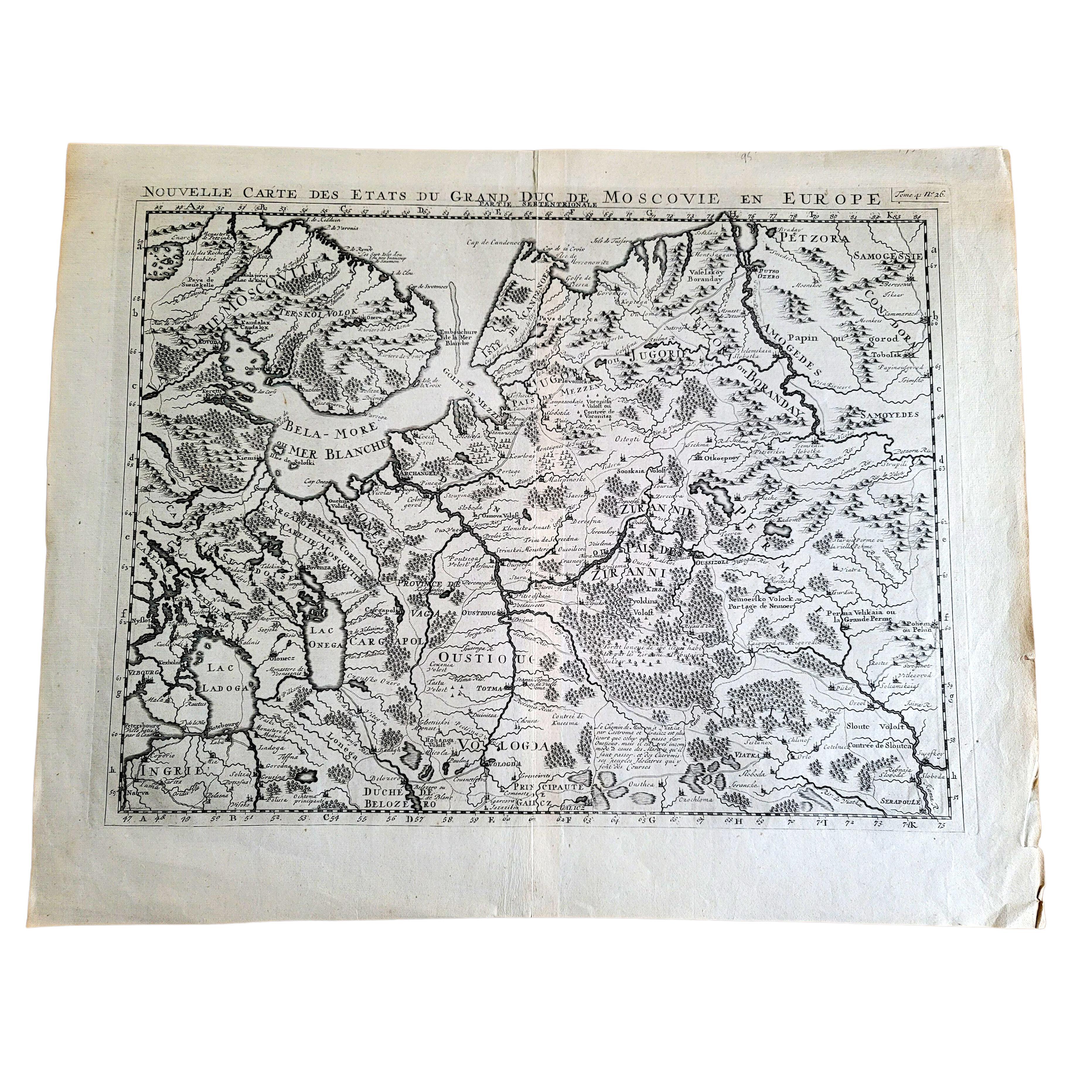
View All1714 Henri Chatelain "Nouvelle Carte Des Etatas Du Grand.Duc De Mos Moscovie Eur
Located in Norton, MA
A 1714 Henri Chatelain map, entitled
"Nouvelle Carte Des Etatas Du Grand Duc De Moscovie En Europe,"
Ricb001
Henri Abraham Chatelain (1684-1743) was a Huguenot pastor of Parisi...
Category
Antique Early 18th Century Dutch Maps
Materials
Paper

1633 Map "La Souverainete De Sedan Et De Raucourt, Et La Prevoste Ric0011
Located in Norton, MA
1653 map entitled
"La Souverainete de Sedan et de Raucourt, et la Prevoste de Doncheri,"
Ric0011
Description:
Lovely map centered on Sedan and Doncheri and the Meuze River fr...
Category
Antique 17th Century Dutch Maps
Materials
Paper

1627 Hendrik Hondius Map Entitled "Vltoniae Orientalis Pars, " Ric.a009
Located in Norton, MA
1627 Hendrik Hondius map entitled
"Vltoniae orientalis pars,"
Ric.a009
Title:
Vltoniae orientalis : pars
Title (alt.) :
Ultoniae orientalis pars
Creator:
Mercator, Gerh...
Category
Antique 17th Century Dutch Maps
Materials
Paper

1633 Map Entitled "Beauvaisis Comitatus Belova Cium, Ric.0002
Located in Norton, MA
1633 map entitled
"Beauvaisis Comitatus Belova Cium,"
Hand Colored
Ric.0002
Description: Cartographer : - Hondius, Henricus 1587-1638
Artists and Engravers:Jodocus Hondius, one of the most notable engravers of his time. He is known for his work in association with many of the cartographers and publishers prominent at the end of the sixteenth and the beginning of the seventeenth century. A native of Flanders, he grew up in Ghent, apprenticed as an instrument and globe maker and map engraver. In 1584, to escape the religious troubles sweeping the Low Countries at that time, he fled to London where he spent some years before finally settling in Amsterdam about 1593. In the London period he came into contact with the leading scientists and geographers of the day and engraved maps in The Mariner\\\\\\\\\\\\\\\'s Mirrour, the English edition of Waghenaer\\\\\\\\\\\\\\\'s Sea Atlas, as well as others with Pieter van den Keere, his brother-in-law. No doubt his temporary exile in London stood him in good stead, earning him an international reputation, for it could have been no accident that Speed chose Hondius to engrave the plates for the maps in The Theatre of the Empire of Great Britaine in the years between 1605 and 1610. In 1604 Hondius bought the plates of Mercator\\\\\\\\\\\\\\\'s Atlas which, in spite of its excellence, had not competed successfully with the continuing demand for the Ortelius Theatrum Orbis Terrarum. To meet this competition Hondius added about 40 maps to Mercator\\\\\\\\\\\\\\\'s original number and from 1606 published enlarged editions in many languages, still under Mercator\\\\\\\\\\\\\\\'s name but with his own name as publisher. These atlases have become known as the Mercator/Hondius series. The following year the maps were reengraved in miniature form and issued as a pocket Atlas Minor. After the death of Jodocus Hondius the Elder in 1612, work on the two atlases, folio and miniature, was carried on by his widow and sons, Jodocus II and Henricus, and eventually in conjunction with Jan Jansson in Amsterdam.
In all, from 1606 onwards, nearly 50 editions with increasing numbers of maps with texts in the main European languages were printed. Summaries of these issues are given under the entry for Gerard Mercator. Jodocus Hondius the Elder * 1588 Maps in The Mariner\\\\\\\\\\\\\\\'s Mirrour (Waghenaer/Ashley) * 1590 World Map...
Category
Antique 17th Century Dutch Maps
Materials
Paper

1657 Janssonius Map of Vermandois and Cappelle, Ric. A-004
Located in Norton, MA
1657 Janssonius map of
Vermandois and Cappelle
Ric.a004
Description: Antique map of France titled 'Descriptio Veromanduorum - Gouvernement de la Cappelle'. Two detailed maps o...
Category
Antique 17th Century Unknown Maps
Materials
Paper

1790 Thomas Stackhouse Map, Entitled "Russia in Europe, " , Ric.a004
Located in Norton, MA
1790 Thomas Stackhouse map, entitled
"Russia in Europe"
Ric.a004
Stackhouse, Thomas
Russia in Europe [map]
London: T. Stackhouse, 1783. Map. Matted hand-colored copper engraving. Image size: 14.5 x 15.25 inches. Mat size: 22.75 x 23.75 inches. A beautiful example of this map of Eastern Europe...
Category
Antique 17th Century Unknown Maps
Materials
Paper

You May Also Like
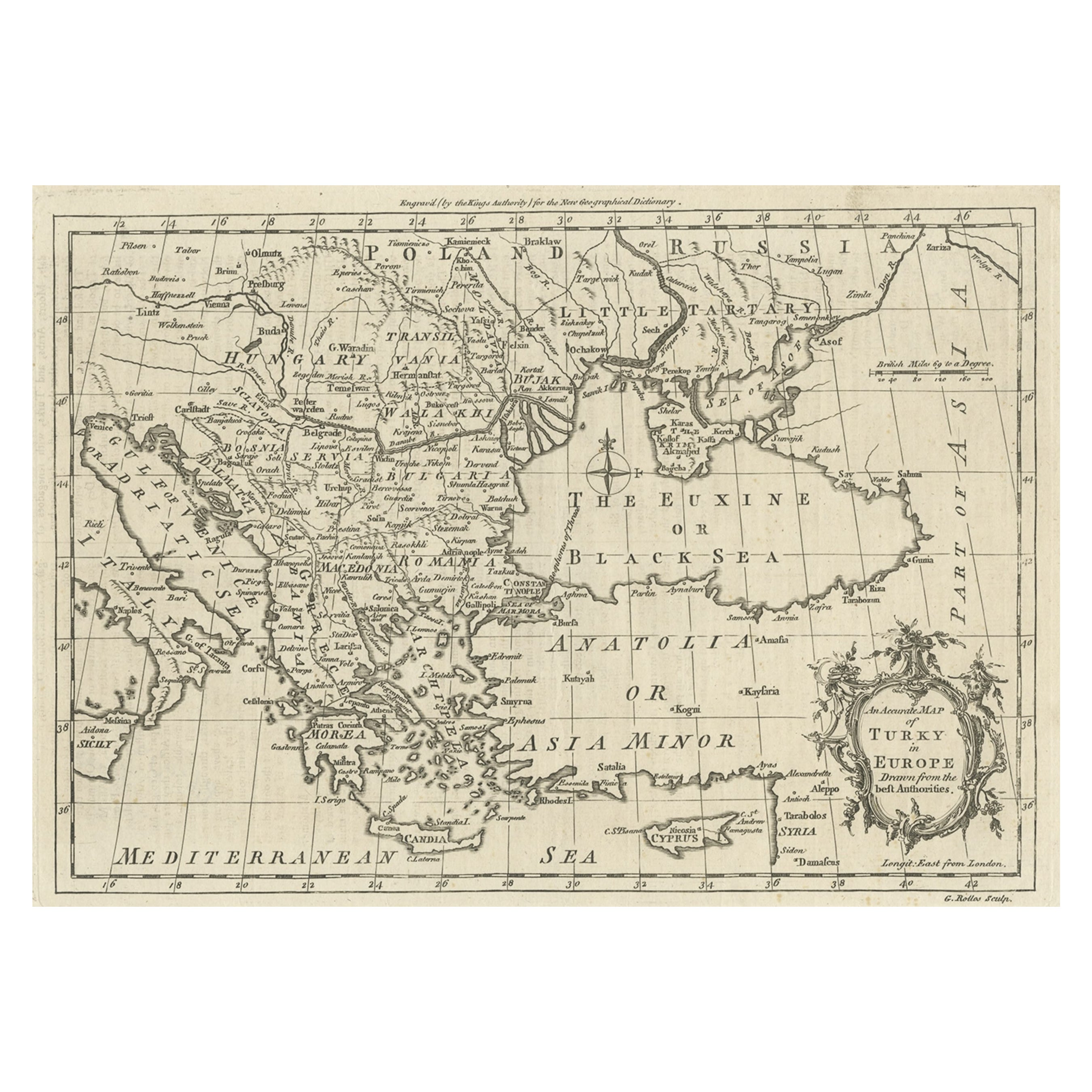
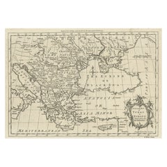
Map of the Ottoman Empire in Europe, incl. the Balkans, Greece & Turkey, c.1760
Located in Langweer, NL
Antique map Turkey titled 'An Accurate Map of Turky in Europe drawn from the best Authorities'.
Map of the Ottoman Empire in Europe, the Balkans, Greece, and Turkey in Europe. Engr...
Category
Antique 1760s Maps
Materials
Paper
$440 Sale Price
20% Off
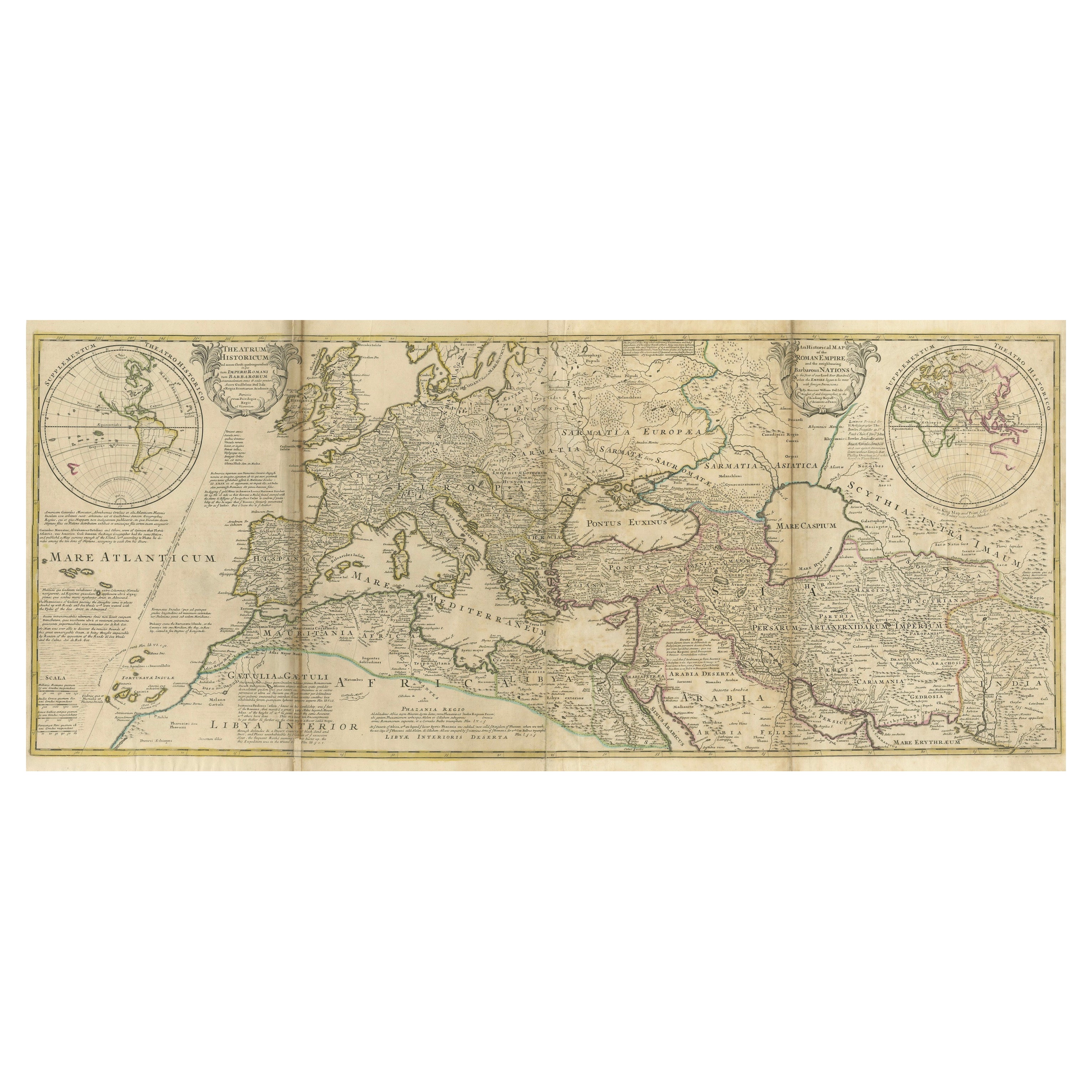
Rare 1730 Roman Empire Map by Moll - Detailed and Engraved Masterpiece
Located in Langweer, NL
An Historical Map of the Roman Empire and the Neighbouring Barbarous Nations by Herman Moll - Circa 1730
This grand and historically significant map of the Roman Empire was create...
Category
Antique 1730s Maps
Materials
Paper
$1,341 Sale Price
20% Off
Antique Map Eastern Mediterranean by D. Stoopendaal 'circa 1710'
Located in Langweer, NL
Antique map Middle East titled 'De Beschryving van de Reysen Pauli en van de Andere Apostelen'. Antique map of the Eastern Mediterranean with details of the travels by Apostle Paul...
Category
Antique Early 18th Century Dutch Maps
Materials
Paper

$336 Sale Price
20% Off
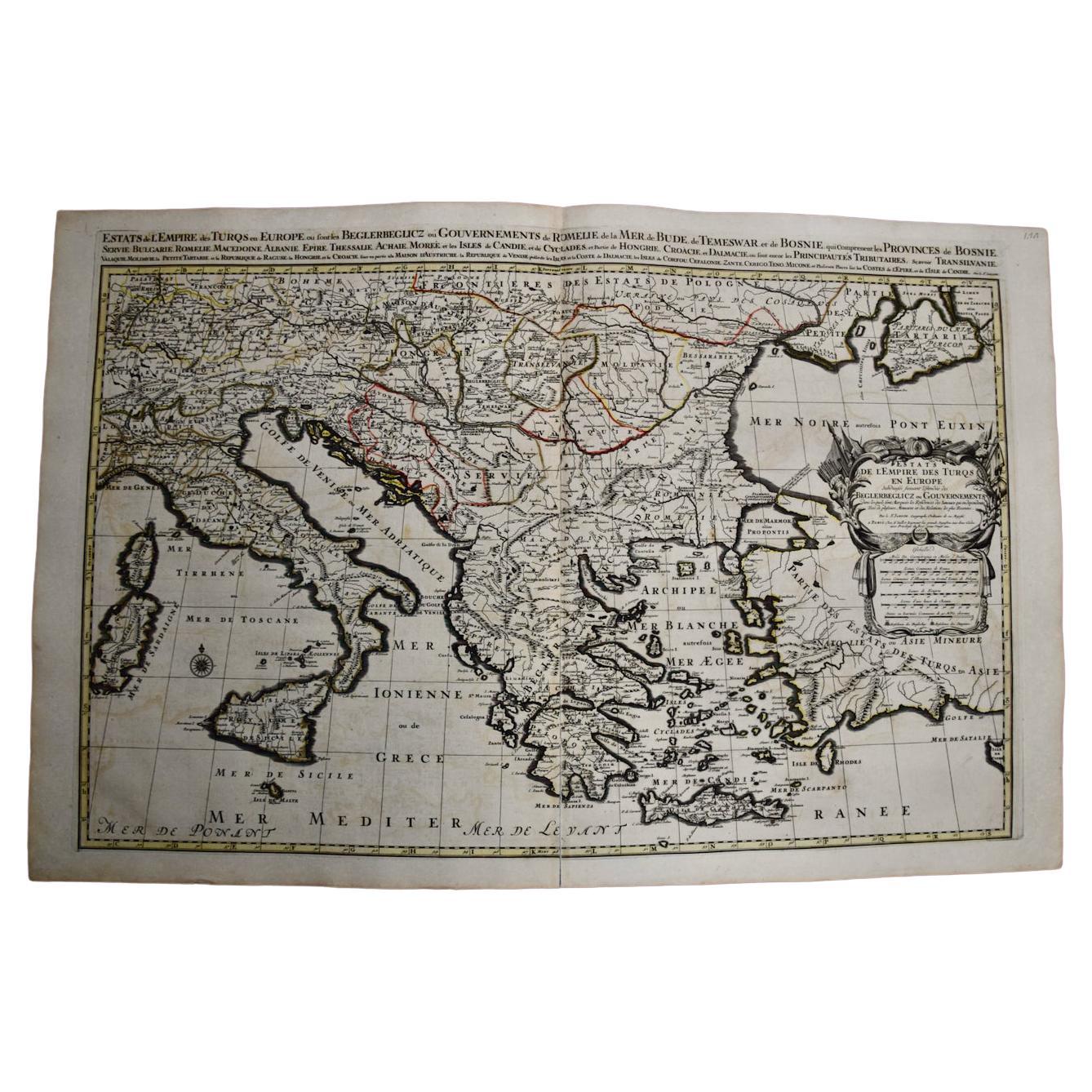
Southern & Eastern Europe: A Large 17th C. Hand-colored Map by Sanson & Jaillot
By Nicolas Sanson
Located in Alamo, CA
This large hand-colored map entitled "Estats de L'Empire des Turqs en Europe, ou sont les Beglerbeglicz our Gouvernements" was originally created by Nicholas Sanson d'Abbeville and t...
Category
Antique 1690s French Maps
Materials
Paper

17th Century Nicolas Visscher Map of Southeastern Europe
Located in Hamilton, Ontario
A beautiful, highly detailed map of southeastern Europe by Nicolas Visscher. Includes regions of Northern Italy (showing the cities Bologna, Padua, and Venice), Bohemia, Austria (sho...
Category
Antique 17th Century Dutch Maps
Materials
Paper

$1,350 Sale Price
38% Off
Antique Map of Russia in Europe by T. Kitchin, circa 1770
Located in Langweer, NL
Antique map titled 'Russia or Moscovy in Europe, drawn from the latest authorities (..)'. An interesting and attractive early 19th century map of Russia in Europe which was engraved ...
Category
Antique Late 18th Century Maps
Materials
Paper

$153 Sale Price
20% Off
More Ways To Browse
Eastern European Painted Furniture
Dutch Artist Black And White
Antique Maps Of Maryland
Gambia Antique Map
Antique Manitoba
Antique Map Of Brooklyn
Antique Map Of Michigan
Cham Antiques
Map Of Native American Tribes
Antique Furniture Halifax Furniture
Antique Furniture Trinidad
Antique Kiel Furniture
Cornwall Map
Marie Galante
Patagonia Map
Shepherd And Hedger
Vignola Furniture
Washington Dc Map