Items Similar to 1720 Maps of the Holy Land: Ancient and Modern by De Fer and Danet

Want more images or videos?
Request additional images or videos from the seller
1 of 9
1720 Maps of the Holy Land: Ancient and Modern by De Fer and Danet
$766.81
£570.74
€640
CA$1,050.34
A$1,168.21
CHF 610
MX$14,215.85
NOK 7,790.66
SEK 7,306.26
DKK 4,872.10
Shipping
Retrieving quote...The 1stDibs Promise:
Authenticity Guarantee,
Money-Back Guarantee,
24-Hour Cancellation
About the Item
1720 Maps of the Holy Land: Ancient and Modern by De Fer and Danet
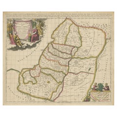
This set of two 1720 maps, published by Nicolas de Fer and Danet in Paris, presents a unique juxtaposition of the Holy Land during ancient times and its modern configuration under Turkish rule. These maps, based on the work of Philippe de la Rue, are intricately detailed and hand-colored in original outline hues, offering a vivid depiction of the region's geographical and historical evolution.
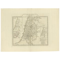
The first map, "Terre Sainte Moderne," showcases the Holy Land as governed by the Turks in the early 18th century. It meticulously illustrates the region's division into administrative areas (sangiacs or governments), highlighting key towns, routes, and natural features. The extensive notes in French provide valuable insights into the area's political and geographical landscape during this period.
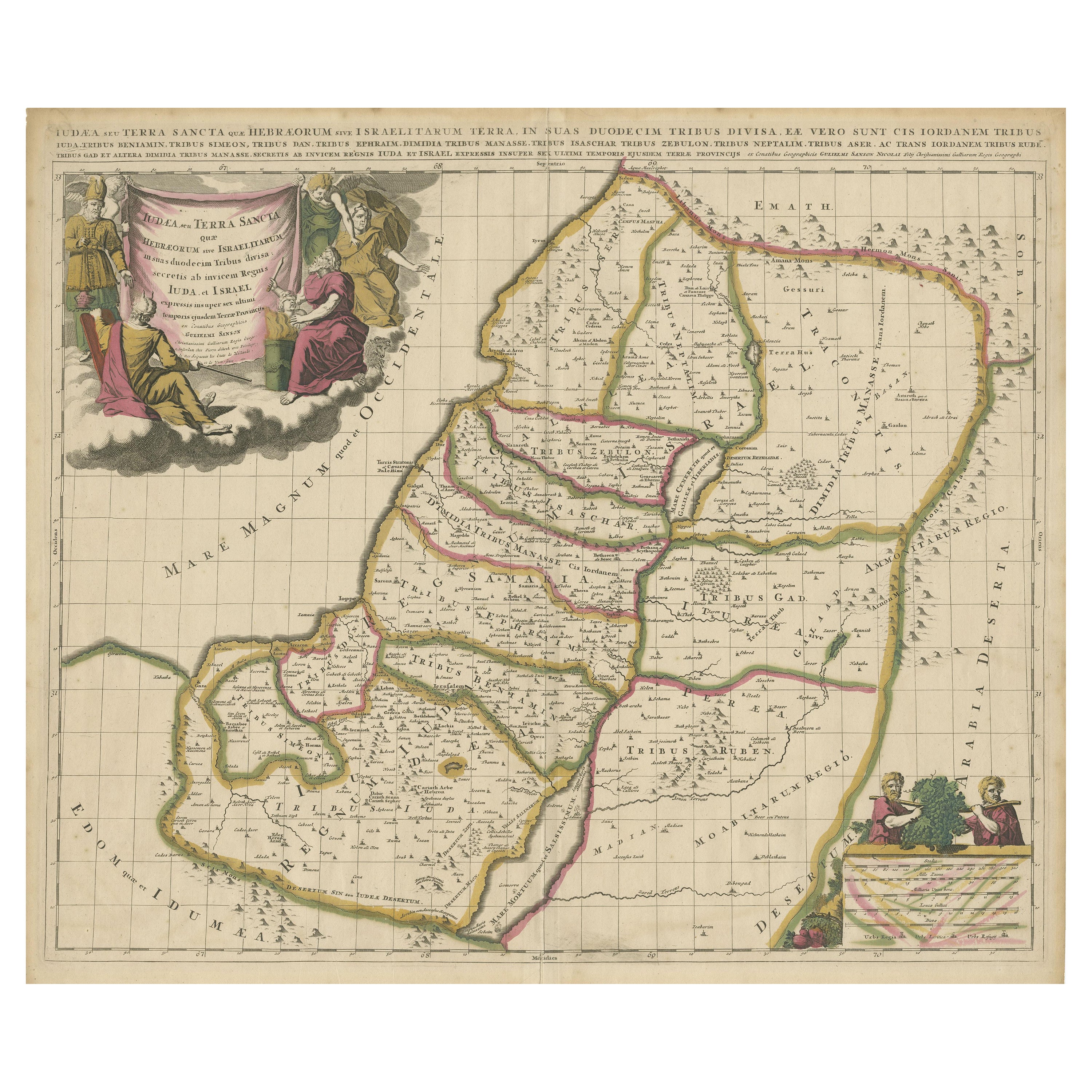
The second map, "Descriptio Acurata Terrae Promissae per Sortes," depicts the ancient Holy Land as described in biblical texts, specifically the territorial divisions among the 12 tribes of Israel. This map is a remarkable representation of the promised land's rich history, featuring key biblical sites and references to significant events.
Both maps are adorned with decorative cartouches and compass roses, reflecting the artistic style and craftsmanship of early 18th-century cartography. The detailed labeling and thoughtful design make these maps not only valuable historical documents but also exquisite decorative pieces.
Condition Report:
Both maps have margins cut close to the image borders and are backed with strong paper for reinforcement. The original outline colors remain vibrant, enhancing the maps’ historical charm.
Framing and Matting Tips:
For a sophisticated display, frame each map individually with an archival mat in neutral tones to complement the delicate colors. Consider using matching antique-style frames to create a harmonious set. UV-protective glass is essential to safeguard the original colors. Including a custom plaque or description with each frame can further highlight their historical and artistic significance. Displaying the maps side by side can create an engaging narrative of the Holy Land's transformation over time.
- Dimensions:Height: 18.12 in (46 cm)Width: 14.38 in (36.5 cm)Depth: 0.01 in (0.2 mm)
- Materials and Techniques:Paper,Engraved
- Period:1720-1729
- Date of Manufacture:circa 1720
- Condition:Both maps have margins cut close to the image borders and are backed with strong paper for reinforcement. The original outline colors remain vibrant, enhancing the maps’ historical charm. Please study the images carefully.
- Seller Location:Langweer, NL
- Reference Number:Seller: BG-14040-5 & BG-14040-61stDibs: LU3054343437522
About the Seller
5.0
Recognized Seller
These prestigious sellers are industry leaders and represent the highest echelon for item quality and design.
Platinum Seller
Premium sellers with a 4.7+ rating and 24-hour response times
Established in 2009
1stDibs seller since 2017
2,502 sales on 1stDibs
Typical response time: <1 hour
- ShippingRetrieving quote...Shipping from: Langweer, Netherlands
- Return Policy
Authenticity Guarantee
In the unlikely event there’s an issue with an item’s authenticity, contact us within 1 year for a full refund. DetailsMoney-Back Guarantee
If your item is not as described, is damaged in transit, or does not arrive, contact us within 7 days for a full refund. Details24-Hour Cancellation
You have a 24-hour grace period in which to reconsider your purchase, with no questions asked.Vetted Professional Sellers
Our world-class sellers must adhere to strict standards for service and quality, maintaining the integrity of our listings.Price-Match Guarantee
If you find that a seller listed the same item for a lower price elsewhere, we’ll match it.Trusted Global Delivery
Our best-in-class carrier network provides specialized shipping options worldwide, including custom delivery.More From This Seller
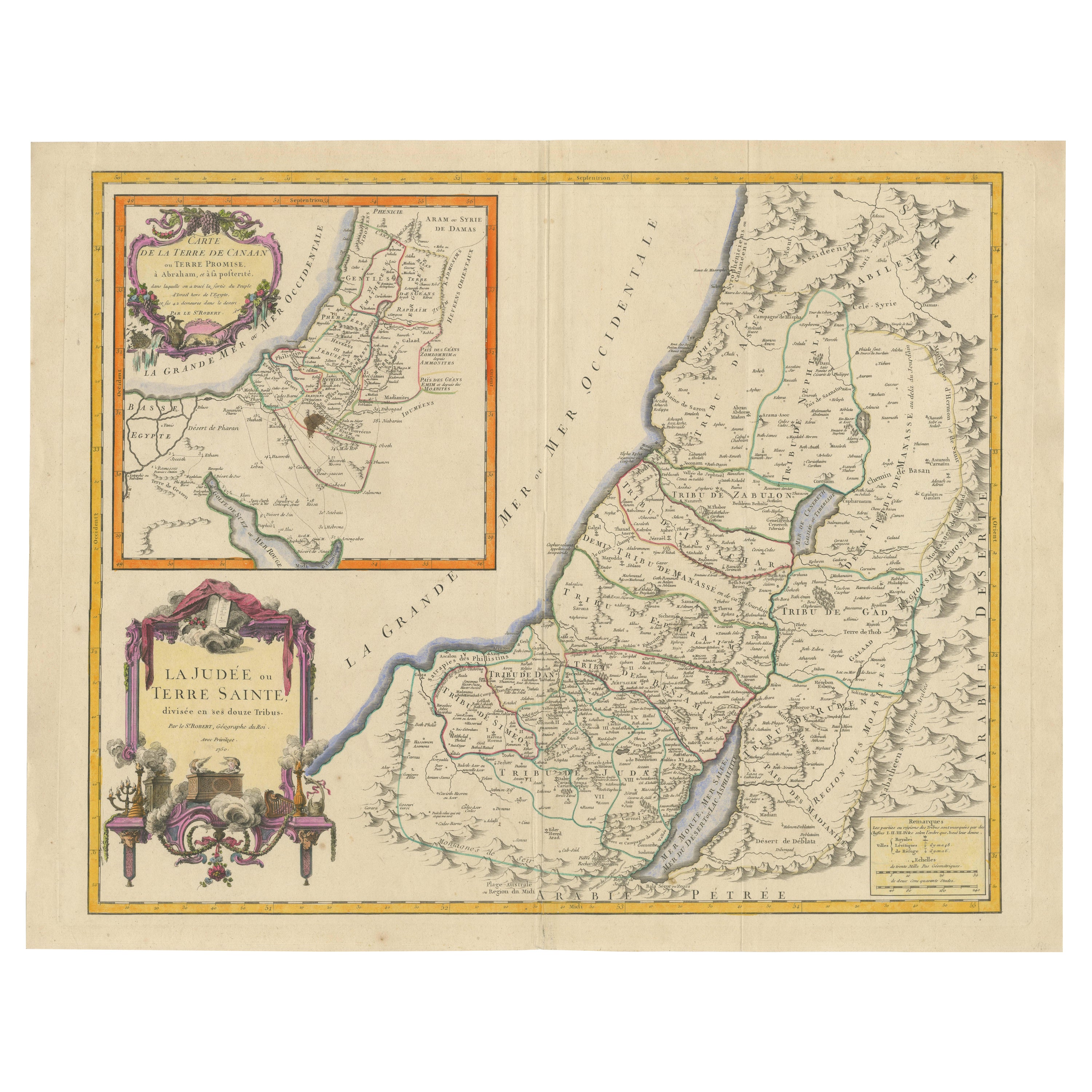
View All1750 Map of the Holy Land: The Land of Canaan and the Twelve Tribes
Located in Langweer, NL
Carte de la Terre de Canaan ou Terre Promise
Cartographer: Le St. Robert
Date of Publication: 1750
This exquisite 18th-century map, 'Carte de la Terre de Canaan ou Terre Promise', w...
Category
Antique 1750s Maps
Materials
Paper

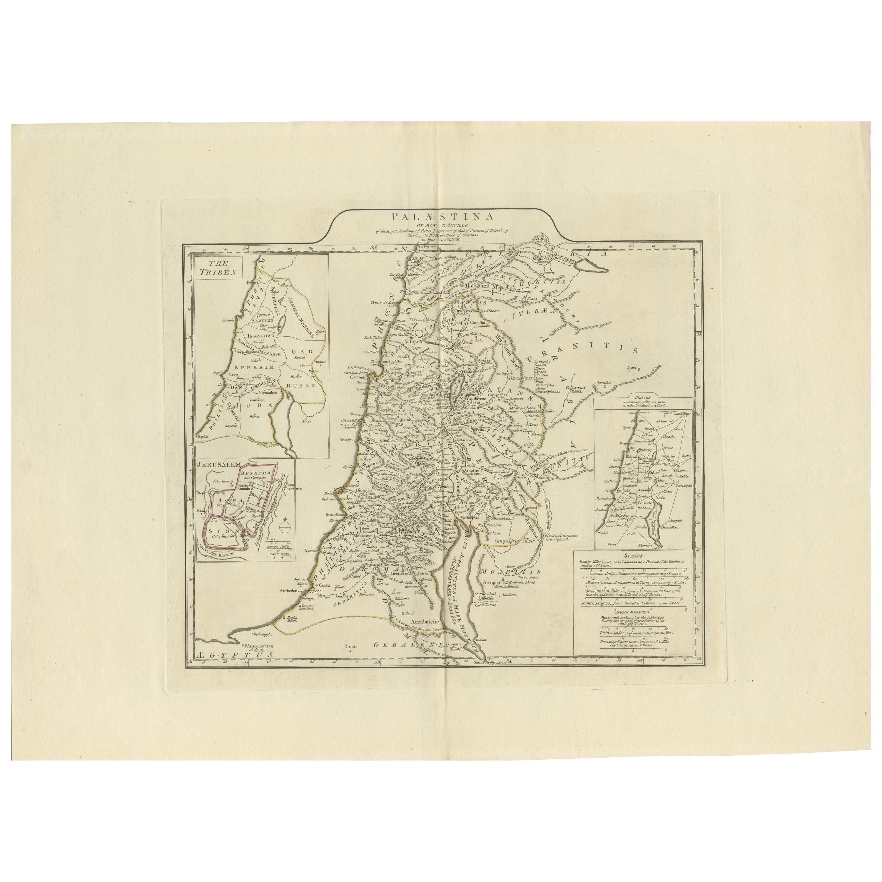
1767 D’Anville Map of the Holy Land: Ancient Divisions and Biblical Geography
Located in Langweer, NL
Ancient Map of Palestine or the Holy Land by D'Anville (1767)
This detailed map, created by the renowned French cartographer Jean Baptiste Bourguignon d'Anville in 1767, depicts the...
Category
Antique 1670s Maps
Materials
Paper
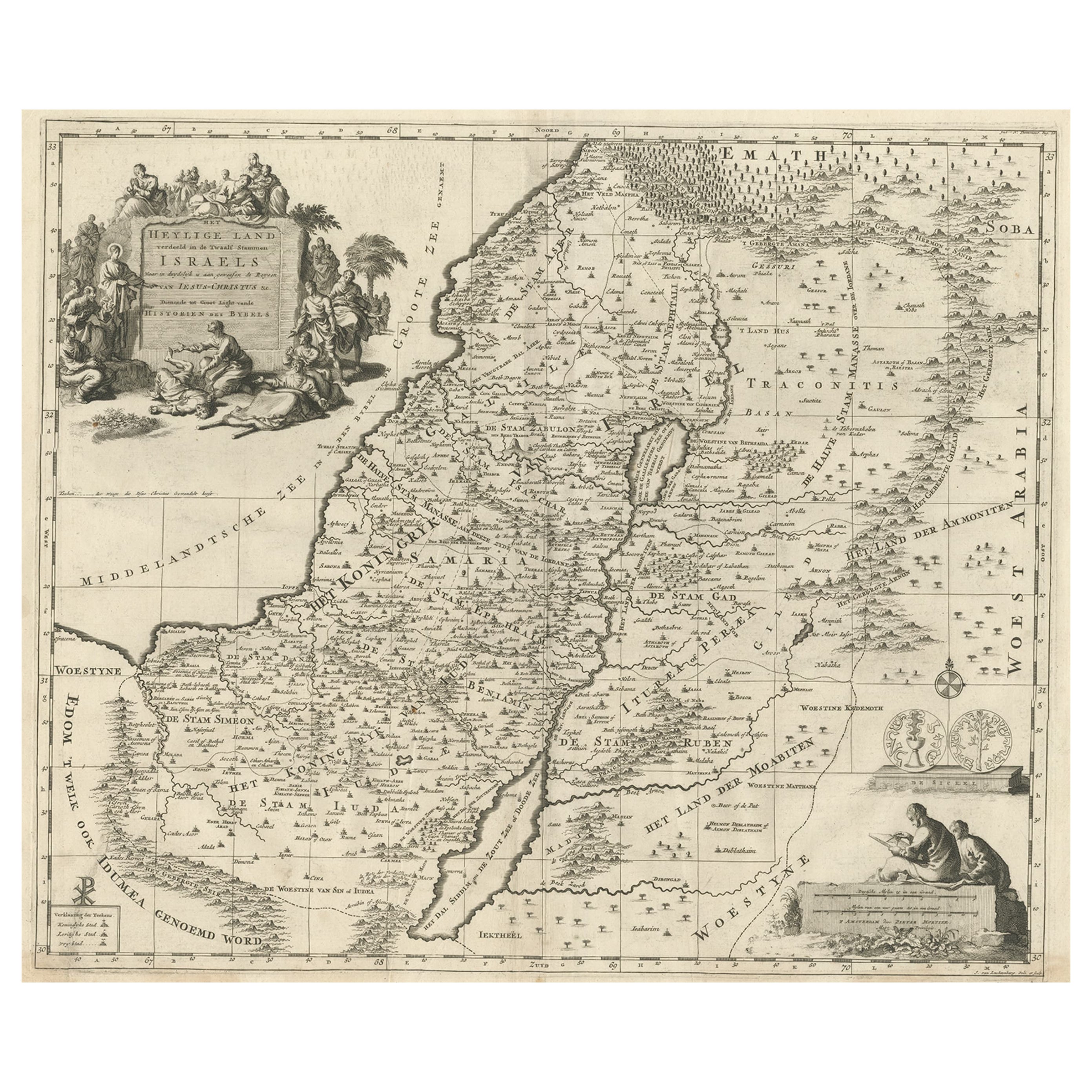
Map of the Holy Land Divided into 12 Tribes, the Travels of Jesus Christ, 1700
Located in Langweer, NL
Antique map titled 'Het Heylige Land verdeeld in de Twaalf Stammen Israels (..)'.
Decorative and detailed map of the Holy Land divided into 12 Tribes, sh...
Category
Antique Early 1700s Maps
Materials
Paper
$469 Sale Price
20% Off
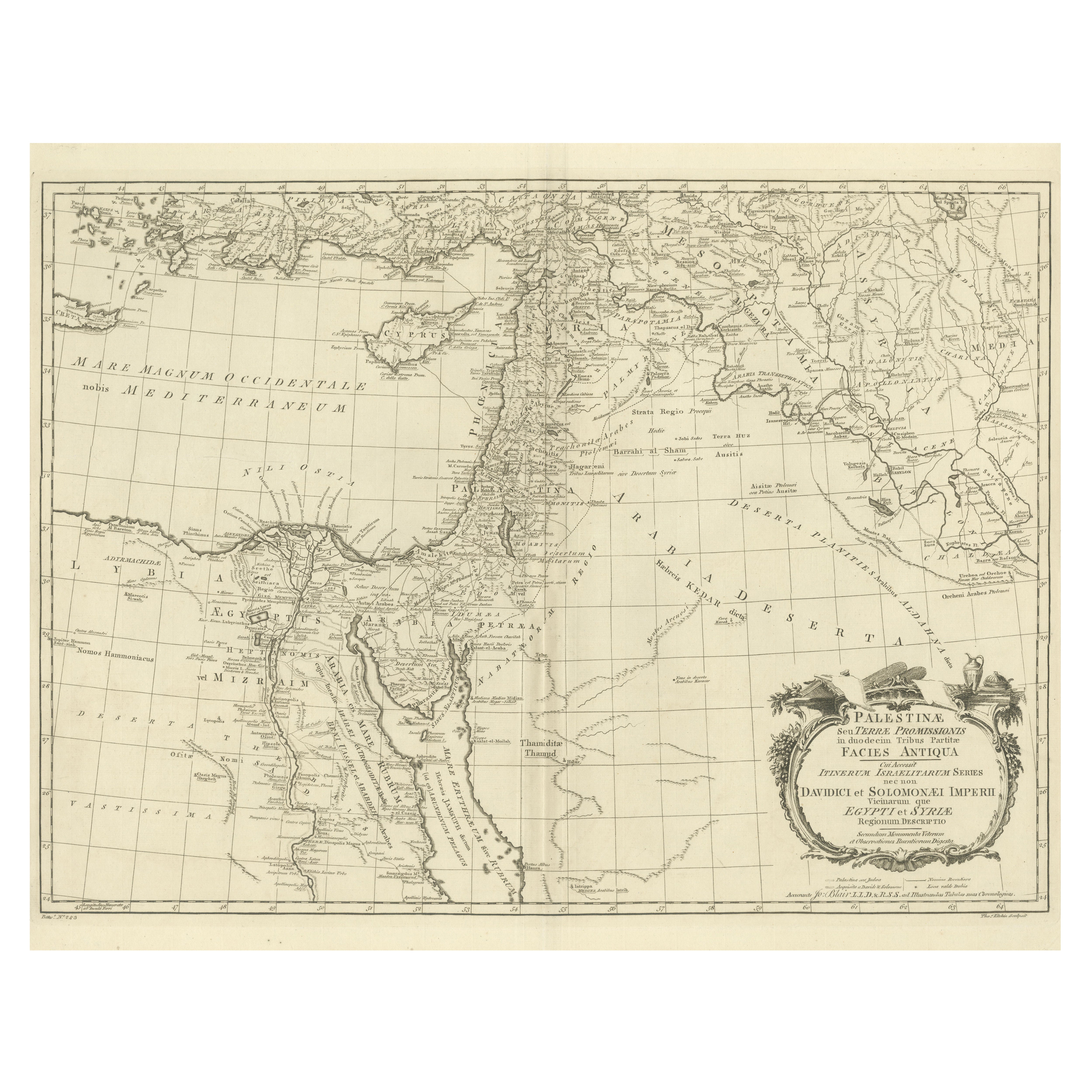
1773 John Blair Map of the Ancient Holy Land: Tribes, Journeys, and Empires
Located in Langweer, NL
Title: 1773 John Blair Map of the Ancient Holy Land: Tribes, Journeys, and Empires
This exceptional map by John Blair, published in London in 1773, offers a richly detailed view o...
Category
Antique 1770s English Maps
Materials
Paper
Antique Map of the Holy Land, Showing the Location of the Various Tribes
Located in Langweer, NL
Antique map titled 'Judaea seu Terra Sancta quae Hebraeorum sive Israelitarum (..)'. Map of The Holy Land, showing the location of the various tribes, in two kingdoms, Judah and Isra...
Category
Antique Early 18th Century Maps
Materials
Paper
$1,150 Sale Price
20% Off
Free Shipping
Antique Map of the Holy Land Described in the Old and New Testament, ca.1660
Located in Langweer, NL
Antique map titled 'Geographiae Sacrae ex Veteri et Novo Testamento Desumptae Tabula Prima quae Totius Orbis Partes Continet.'
Map of the lands described in the Old and New Testame...
Category
Antique 1660s Maps
Materials
Paper

$814 Sale Price
20% Off
You May Also Like
Map Holy Land La Terre Sainte Engraved van Loon Published N de Fer 1703 French
Located in BUNGAY, SUFFOLK
La Terre Sainte, The Holy Land, Tiree Des Memoires De M.De.La Rue. Par N. de Fer. Geographe de Sa Majeste Catoliq et de Monseigneur le Dauphin. Avec Privil du Roi 1703
Detailed map of the Holy Land from Nicholas de Fer's L'Atlas Curieux ou le Monde. East is oriented at the top.
MAKER Nicolas de Fer 1646-1720
The French cartographer and engraver, Nicolas de Fer, was a master at creating maps that were works of art. The maps that he published were printed during the Baroque period when the decorative arts were characterized by ornate detail. De Fer’s detailed maps and atlases were valued more for their decorative content than their geographical accuracy.
Nicolas de Fer was born in 1646. His father, Antoine de Fer, owned a mapmaking firm. At the age of twelve, Nicolas was apprenticed to a Parisian engraver named Louis Spirinx. The family business was starting to decline when his father died in 1673. Nicolas de Fer’s mother, Genevieve, took over the business after the death of her husband. In 1687 the business was passed on to Nicolas and the profits increased after he took over the firm. Nicolas de Fer was a prolific cartographer who produced atlases and hundreds of single maps. He eventually became the official geographer to King Louis XIV of France and King Philip V...
Category
Antique Early 1700s French Louis XIV Maps
Materials
Paper

1633 Map "La Souverainete De Sedan Et De Raucourt, Et La Prevoste Ric0011
Located in Norton, MA
1653 map entitled
"La Souverainete de Sedan et de Raucourt, et la Prevoste de Doncheri,"
Ric0011
Description:
Lovely map centered on Sedan and Doncheri and the Meuze River fr...
Category
Antique 17th Century Dutch Maps
Materials
Paper

Portugal: A Large 17th Century Hand-colored Map by Sanson and Jaillot
By Nicolas Sanson
Located in Alamo, CA
This large hand-colored map entitled "Le Royaume de Portugal et des Algarves Divisee en see Archeveches, Eveches et Territoires Par le Sr Sanson" was originally created by Nicholas S...
Category
Antique 1690s French Maps
Materials
Paper

1718 Ides & Witsen Map "Route D'amsterdam a Moscow Et De La Ispahan Et Gamron
Located in Norton, MA
1718 Ides & Witsen map, entitled
"Route D'Amsterdam A Moscow Et De La Ispahan Et Gamron,"
Ric.b005
Subject: Eastern Europe and Central Asia
Period: 1718 (published)
Publicati...
Category
Antique Early 18th Century Dutch Maps
Materials
Paper

1751 Map of Spain Castilla Robert De Vaugondy 1st Edition, Ric.a001
Located in Norton, MA
Large Spain Castilla Robert De Vaugondy
1751 1st Edition
-Colored- Ric.a001
Coming from a family of cartographers, a descendant of the famous Nicolas Sanson and ordinary geographer of the king, Gilles Robert de Vaugondy makes himself known by his maps of the French provinces.
He published an Essay on the History of Geography (1755) from which he excluded the physical geography "too systematic". After a Small Atlas (1748), he draws a universal Atlas (1758), a portable Atlas (1762).
His Atlas of the revolutions of the globe remains unpublished. His warnings and prefaces, his book reviews reveal a Cartesian mind and solid knowledge.
Very early, he associates with his works his son Didier who publishes, since 1742, the methodical tables of Nicolas Sanson, two Globes, one terrestrial, the other celestial (1752).
He is credited with a map of Poland...
Category
Antique 18th Century Unknown Maps
Materials
Paper

1714 Henri Chatelain "Nouvelle Carte Des Etatas Du Grand.Duc De Mos Moscovie Eur
Located in Norton, MA
A 1714 Henri Chatelain map, entitled
"Nouvelle Carte Des Etatas Du Grand Duc De Moscovie En Europe,"
Ricb001
Henri Abraham Chatelain (1684-1743) was a Huguenot pastor of Parisi...
Category
Antique Early 18th Century Dutch Maps
Materials
Paper

More Ways To Browse
Antique Ancient Key
French Matting
Terre De Fer
Carlo Scarpa 1934 Chairs
Christofle Marly
1900 Antique Chairs
Glass Table Italian Round
Alvar Aalto Poster
Geometric Metal Table
Post Modern High Chairs
Vintage Vine Rug
Cancel An Order
Antique Framing Square
Silver Metal Chair
Swedish Kilim
Vintage Scandanavian Chairs
Vintage Tropical Furniture
19th Century Red Glass