Items Similar to 1750 Bellin Map of the Red River (Tonkin River) and Hanoi, Vietnam


Want more images or videos?
Request additional images or videos from the seller
1 of 10
1750 Bellin Map of the Red River (Tonkin River) and Hanoi, Vietnam
$155.71
£115.39
€130
CA$212.57
A$236.47
CHF 123.96
MX$2,889.65
NOK 1,578.51
SEK 1,485.95
DKK 989.81
Shipping
Retrieving quote...The 1stDibs Promise:
Authenticity Guarantee,
Money-Back Guarantee,
24-Hour Cancellation
About the Item
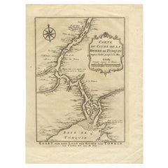
Title: 1750 Bellin Map of the Red River and Hanoi, Vietnam
Description: This finely engraved eighteenth-century French map, titled Carte du Cours de la Riviere de Tunquin, was created by the renowned cartographer Jacques-Nicolas Bellin and published in 1750. It depicts the course of the Red River, historically referred to as the Tonkin River, from Hanoi, labeled as Cacho, Ville Capitale du Tunquin, to the Gulf of Tonkin, labeled as Baye de Tunquin. Bellin’s work was based on navigational surveys by an English explorer, as stated in the title, reflecting the growing European interest in Southeast Asia during the early colonial period.
The Red River Delta was a crucial region for trade and agriculture, forming the backbone of Vietnam’s economic and cultural history. The river originates in China and flows through northern Vietnam, passing through Hanoi before emptying into the Gulf of Tonkin. This map captures the strategic importance of the river, as it served as a major trade route for goods and a point of interest for European navigators, merchants, and missionaries seeking access to Indochina.
The map includes numerous geographical details. Hanoi is prominently labeled as the capital of Tonkin, a historical term used by Europeans to describe northern Vietnam. The surrounding settlements, islands, and tributaries are carefully marked, illustrating the intricate network of waterways that characterized the region. Notable features include Île de la Potterie, referring to a location known for ceramic production, and various sandbanks and fortified locations along the river.
A decorative compass rose is placed in the upper left corner, reinforcing the map’s navigational purpose. The scale of measurement is provided in French leagues, labeled as Grandes Lieues de France, indicating that the map was designed for use by explorers and traders.
Bellin’s maps were among the most influential and widely circulated of the eighteenth century, produced for the French Dépot de la Marine, or Naval Depot, and included in important atlases of the time. This map reflects France’s interest in Southeast Asia, preceding the country’s later colonial ambitions in Vietnam.
Cartographer and Source:
Jacques-Nicolas Bellin, who lived from seventeen hundred three to seventeen hundred seventy-two, was a French hydrographer and cartographer who served as the chief cartographer for the French Navy’s Dépot des Cartes et Plans de la Marine. His maps were widely published in maritime atlases and travel accounts, providing some of the most detailed representations of colonial territories and trade routes. This map was included in one of his key works on Southeast Asia, documenting European maritime knowledge of the region.
Condition Report:
The paper is in good condition for its age, with a strong laid texture and visible chain lines, characteristic of high-quality eighteenth-century French printing. The engraving remains sharp and well-defined, with clear place names and finely detailed coastlines.
There is light age-toning, especially along the edges, which is common for antique maps of this period. Wide and clean margins ensure that the map is well-suited for framing. There are no major tears, stains, or repairs, making this a very fine example of Bellin’s cartography.
Framing Recommendations:
To properly display and protect this antique map, consider using archival-quality materials.
For matting and backing, choose acid-free, museum-grade board to prevent further aging. A double mat with a neutral outer mat and an inner accent in soft beige or gray will enhance the historical details of the engraving.
A classic black, dark walnut, or gilded wooden frame complements the map’s historical aesthetic. A distressed or antique-style frame with subtle carvings can further highlight its period charm.
For protection, UV-resistant museum glass or acrylic is highly recommended to prevent fading. Anti-reflective glass ensures clear visibility of the fine engraving details.
For mounting, avoid direct adhesives. Instead, use archival-quality corner mounts or Japanese paper hinges to secure the map without causing damage.
The framed map should be displayed in a controlled environment, away from direct sunlight, humidity, and extreme temperature changes. Ideal locations include a study, library, or gallery, where its historical and artistic value can be fully appreciated.
This seventeen hundred fifty Bellin map of the Red River and Hanoi is a significant historical artifact that reflects early European efforts to document the geography of Vietnam and Southeast Asia. It is an exceptional piece for collectors of antique maps, maritime history, and French colonial cartography.
- Dimensions:Height: 10.12 in (25.7 cm)Width: 7.21 in (18.3 cm)Depth: 0.01 in (0.2 mm)
- Materials and Techniques:Paper,Engraved
- Period:1750-1759
- Date of Manufacture:1750
- Condition:Good condition with light age-toning, especially along the edges, which is common for antique maps of this period. Wide and clean margins ensure that the map is well-suited for framing. There are no major tears, stains, or repairs.
- Seller Location:Langweer, NL
- Reference Number:Seller: BG-035581stDibs: LU3054343931192
About the Seller
5.0
Recognized Seller
These prestigious sellers are industry leaders and represent the highest echelon for item quality and design.
Platinum Seller
Premium sellers with a 4.7+ rating and 24-hour response times
Established in 2009
1stDibs seller since 2017
2,502 sales on 1stDibs
Typical response time: <1 hour
- ShippingRetrieving quote...Shipping from: Langweer, Netherlands
- Return Policy
Authenticity Guarantee
In the unlikely event there’s an issue with an item’s authenticity, contact us within 1 year for a full refund. DetailsMoney-Back Guarantee
If your item is not as described, is damaged in transit, or does not arrive, contact us within 7 days for a full refund. Details24-Hour Cancellation
You have a 24-hour grace period in which to reconsider your purchase, with no questions asked.Vetted Professional Sellers
Our world-class sellers must adhere to strict standards for service and quality, maintaining the integrity of our listings.Price-Match Guarantee
If you find that a seller listed the same item for a lower price elsewhere, we’ll match it.Trusted Global Delivery
Our best-in-class carrier network provides specialized shipping options worldwide, including custom delivery.More From This Seller
View AllAntique Map of the Tonkin River ‘Vietnam’ by J.N. Bellin, 1764
Located in Langweer, NL
One of the maps produced by Bellin for Prevost d'Exiles' influential travel book, ‘L'Histoire Generale des Voyages’. This map depicts part of Southeast Asia, most likely northern Vie...
Category
Antique Mid-18th Century Maps
Materials
Paper

$234 Sale Price
20% Off
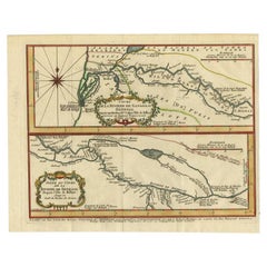
Antique Map of the Tunquin River and Bay to Cacho, the Capital City, Siam, 1758
Located in Langweer, NL
Antique map titled ‘Kaart van den Loop der Rivier van Tonkin van Cacho tot aan de Zee / Carte du Cours de la Riviere de Tunquin Depuis Cacho jusqu'à la Mer J. v. Schley direx.’ Detailed map of the Tunquin River and Bay, extending north to Cacho, the capital...
Category
Antique 18th Century Maps
Materials
Paper
$210 Sale Price
20% Off
Antique Map of the Tunquin River and Bay, Siam, 1757
Located in Langweer, NL
Antique map titled ‘Carte du Cours de la Riviere de Tunquin Depuis Cacho jusqu'à la Mer’. Detailed map of the Tunquin River and Bay, extending north to Cacho, the capital city. Made ...
Category
Antique 18th Century Maps
Materials
Paper

$220 Sale Price
20% Off
Antique Map of the Gambia River by J. Van Schley, circa 1750
Located in Langweer, NL
"Carte de la Riviere de Gambra ou Gambie. Depuis son Embouchure Jusqu a Eropina". Orig. copper-engraving after Capt. J. Leach's map of the region from 1732. With ornamental title cartouche and Dutch...
Category
Antique Mid-18th Century Maps
Materials
Paper

$349 Sale Price
20% Off
Antique Map of the Mouth of the Yangtze River 'China' by J.N. Bellin, 1764
Located in Langweer, NL
This detailed regional map of China is a historical cartographic work from the mid-18th century and is attributed to Antoine-François Prévost, a prominent French cartographer and geo...
Category
Antique Mid-18th Century Maps
Materials
Paper

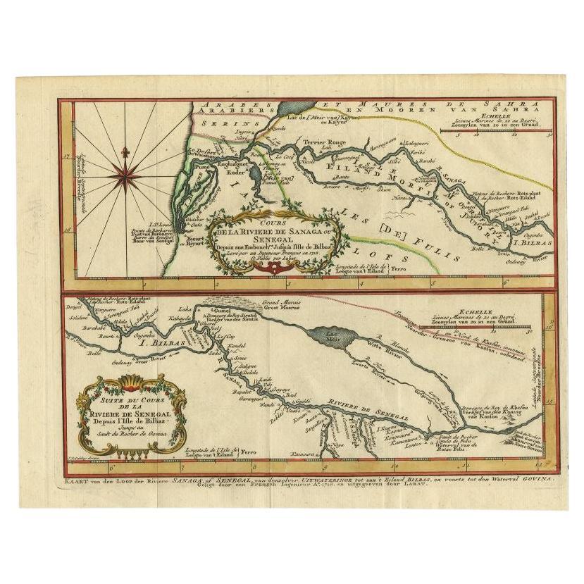
Antique Map of the Sanaga River, Senegal, 1747
Located in Langweer, NL
Antique map titled 'Cours De La Riviere De Sanaga Ou Senegal (..) - Kaart van den Loop der Riviere Sanaga (..)'. Attractive double map of the Sanaga River, Senegal, Africa. This map ...
Category
Antique 18th Century Maps
Materials
Paper
$325 Sale Price
20% Off
You May Also Like
West Coast of Africa, Guinea & Sierra Leone: An 18th Century Map by Bellin
By Jacques-Nicolas Bellin
Located in Alamo, CA
Jacques Bellin's copper-plate map entitled "Partie de la Coste de Guinee Dupuis la Riviere de Sierra Leona Jusquau Cap das Palmas", depicting the coast of Guinea and Sierra Leone in ...
Category
Antique Mid-18th Century French Maps
Materials
Paper

Antique French Map of Asia Including China Indoneseia India, 1783
Located in Amsterdam, Noord Holland
Very nice map of Asia. 1783 Dedie au Roy.
Additional information:
Country of Manufacturing: Europe
Period: 18th century Qing (1661 - 1912)
Condition: Overall Condition B (Good Used)...
Category
Antique 18th Century European Maps
Materials
Paper

$648 Sale Price
20% Off
1627 Hendrik Hondius Map Entitled "Vltoniae Orientalis Pars, " Ric.a009
Located in Norton, MA
1627 Hendrik Hondius map entitled
"Vltoniae orientalis pars,"
Ric.a009
Title:
Vltoniae orientalis : pars
Title (alt.) :
Ultoniae orientalis pars
Creator:
Mercator, Gerh...
Category
Antique 17th Century Dutch Maps
Materials
Paper

Antique 1803 Italian Map of Asia Including China Indoneseia India
Located in Amsterdam, Noord Holland
Antique 1803 Italian Map of Asia Including China Indoneseia India
Very nice map of Asia. 1803.
Additional information:
Type: Map
Country of Manufacturing: Europe
Period: 19th centu...
Category
Antique 19th Century European Maps
Materials
Paper

$584 Sale Price
20% Off
Super Rare Antique French Map of Chine and the Chinese Empire, 1780
Located in Amsterdam, Noord Holland
Super Rare Antique French Map of Chine and the Chinese Empire, 1780
Very nice map of Asia. 1780 Made by Bonne.
Additional information:
Type: Map
...
Category
Antique 18th Century European Maps
Materials
Paper

$584 Sale Price
33% Off
1654 Joan Blaeu Map the Sutherland, Scotland, Entitled "Southerlandia, "Ric0007
Located in Norton, MA
1654 Joan Blaeu map of the
Sutherland, Scotland, entitled
"Southerlandia,"
Hand Colored
Ric0007
Description:
Lovely map centered on Sedan and D...
Category
Antique 17th Century Dutch Maps
Materials
Paper

More Ways To Browse
French Vietnam
Vietnam Antiques
French Matting
Wooden Compass
Antique Key Chain
Acrylic Trolley
English Rose China
Live Edge Black Walnut
Antique Wooden Carts
Antique Wooden Trolley
Merchant Navy
Japanese Compass
French Indochina
Antique Wooden Compass
Carving Trolley
Library Trolley
Library Cart
French Colonial Vietnam