Items Similar to 1788 Map of Europe - France, Italy, Spain, Germany, Great Britain & Ireland


Want more images or videos?
Request additional images or videos from the seller
1 of 9
1788 Map of Europe - France, Italy, Spain, Germany, Great Britain & Ireland
$1,058.58
$1,323.2320% Off
£793.47
£991.8420% Off
€896
€1,12020% Off
CA$1,454.31
CA$1,817.8920% Off
A$1,623.60
A$2,029.5020% Off
CHF 850.74
CHF 1,063.4320% Off
MX$19,874.48
MX$24,843.1020% Off
NOK 10,804.44
NOK 13,505.5520% Off
SEK 10,187.22
SEK 12,734.0220% Off
DKK 6,820.68
DKK 8,525.8520% Off
About the Item
Title: "1788 Map of Europe - France, Italy, Spain, Germany, Great Britain & Ireland by D'Anville"
Description:
This detailed map of Europe, titled "First Part of the Map of Europe, Containing France, Italy, Spain, Germany, Great Britain & Ireland," was published in 1788. The map was based on the original work by renowned French cartographer Jean Baptiste Bourguignon d'Anville and was produced under the patronage of the Duke of Orleans. The map was drawn and engraved for J. Harrison, London, as stated in the lower margin, with the publishing date marked as December 1st, 1788.
This map reflects the high level of cartographic skill during the late 18th century, showcasing intricate details of the various regions, including boundaries, cities, and geographical features. D'Anville was known for his meticulous research and was one of the most respected geographers of his time, often recognized for his contributions to geographical accuracy. This particular map shows the political divisions of Europe during a tumultuous period just prior to the French Revolution.
The map has an attractive decorative cartouche, typical of maps from this era, which adds an artistic element to the presentation. It remains an important historical document, providing a glimpse into how Europe was perceived and divided just before significant political changes shaped the continent.
Condition: The map is in very good condition for its age, with general age-related toning and some light scattered foxing typical of maps from the late 18th century. The hand coloring is well-preserved and enhances the details of the various regions. There is a faint horizontal crease near the center, but it does not detract significantly from the visual appeal of the piece. The margins are wide, and there are no tears or significant stains, making this a well-preserved example of an 18th-century cartographic work.
- Dimensions:Height: 31.5 in (80 cm)Width: 21.07 in (53.5 cm)Depth: 0.01 in (0.2 mm)
- Materials and Techniques:Paper,Engraved
- Period:1780-1789
- Date of Manufacture:1788
- Condition:The map is in very good condition for its age, with general age-related toning and some light scattered foxing typical of maps from the late 18th century. The hand coloring is well-preserved.
- Seller Location:Langweer, NL
- Reference Number:Seller: BG-13840-61stDibs: LU3054342585372
About the Seller
5.0
Recognized Seller
These prestigious sellers are industry leaders and represent the highest echelon for item quality and design.
Platinum Seller
Premium sellers with a 4.7+ rating and 24-hour response times
Established in 2009
1stDibs seller since 2017
2,513 sales on 1stDibs
Typical response time: <1 hour
- ShippingRetrieving quote...Shipping from: Langweer, Netherlands
- Return Policy
Authenticity Guarantee
In the unlikely event there’s an issue with an item’s authenticity, contact us within 1 year for a full refund. DetailsMoney-Back Guarantee
If your item is not as described, is damaged in transit, or does not arrive, contact us within 7 days for a full refund. Details24-Hour Cancellation
You have a 24-hour grace period in which to reconsider your purchase, with no questions asked.Vetted Professional Sellers
Our world-class sellers must adhere to strict standards for service and quality, maintaining the integrity of our listings.Price-Match Guarantee
If you find that a seller listed the same item for a lower price elsewhere, we’ll match it.Trusted Global Delivery
Our best-in-class carrier network provides specialized shipping options worldwide, including custom delivery.More From This Seller
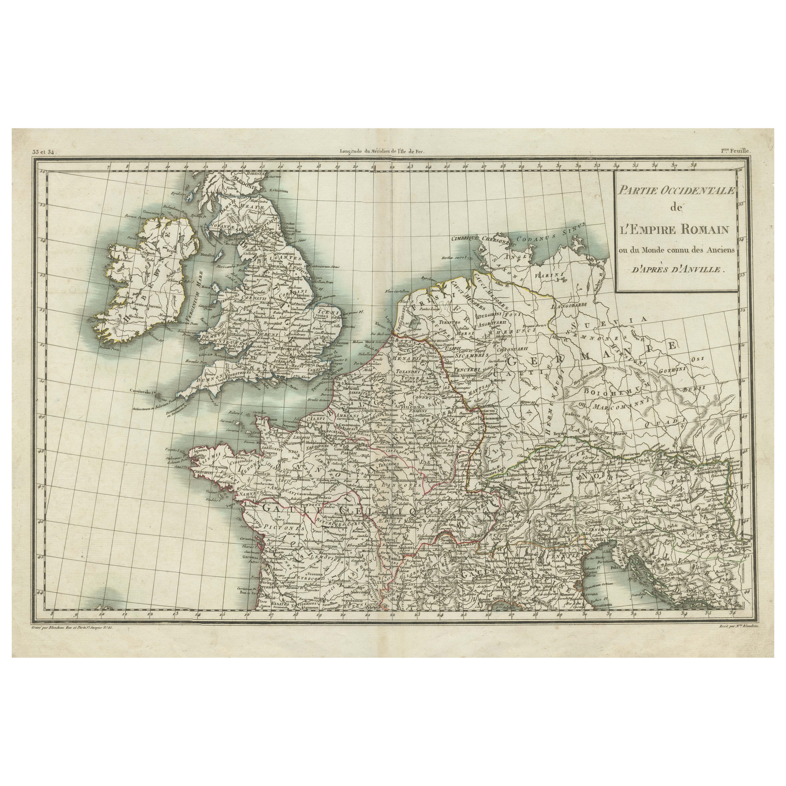
View AllWestern Roman Empire Map: British Isles & Gaul - 1802 Tardieu Atlas
Located in Langweer, NL
Antique Map Description and title: "Partie Occidentale de l'Empire Romain ou du Monde connu des Anciens d'Après d'Anville"
Publication Details:
- **Atlas Title:** Nouvel Atlas Univ...
Category
Antique Early 1800s Maps
Materials
Paper
$415 Sale Price
20% Off
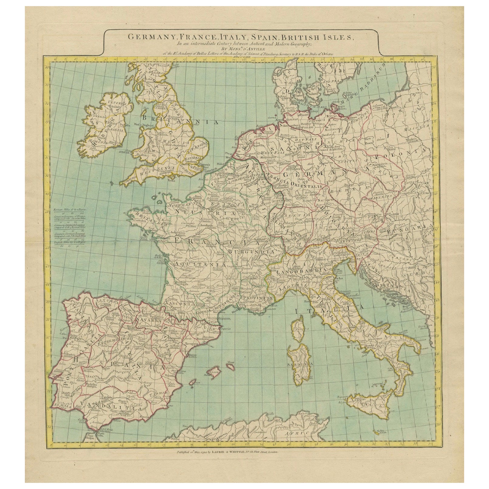
Map of Europe Highlighting Ancient and Modern Geographical Divisions (1794)
Located in Langweer, NL
Map of Europe Highlighting Ancient and Modern Geographical Divisions (1794). Germany, France, Italy, Spain, and the British Isles – Map by D’Anville (1794).
This detailed 18th-cent...
Category
Antique 1790s Maps
Materials
Paper
$1,597 Sale Price
20% Off
Political Map of Europe: Early 19th Century, from the 1802 Tardieu Atlas
Located in Langweer, NL
Antique Map Description
Title: Carte Générale et Politique de l'Europe
Publication Details:
- **Atlas Title:** Nouvel Atlas Universel de Géographie Ancienne et Moderne
- **Purpose...
Category
Antique Early 1800s Maps
Materials
Paper

$453 Sale Price
20% Off
Antique Map of Europe by Wyld '1845'
Located in Langweer, NL
Antique map titled 'Europe'. Original antique map of Europe. This map originates from 'An Atlas of the World, Comprehending Separate Maps of its ...
Category
Antique Mid-19th Century Maps
Materials
Paper

$141 Sale Price
20% Off
Antique Map of Europe Stretching from Northern Africa to the Baltic Sea, 1719
Located in Langweer, NL
Antique map titled 'Carte de la Germanie et les diferents Etats ou ses Peuples ont porté leurs conquestes'. Original antique map of Europe stretching from northern Africa to the Balt...
Category
Antique 18th Century Maps
Materials
Paper

$453 Sale Price
20% Off
Antique Map of Europe by Keizer & de Lat, 1788
Located in Langweer, NL
Antique map titled 'Kaartje van Europa (..)'. Uncommon original antique map of Europe. This map originates from 'Nieuwe Natuur- Geschied- en Handelkundige Zak- en Reisatlas' by Gerri...
Category
Antique Late 18th Century Maps
Materials
Paper

$378 Sale Price
20% Off
You May Also Like
Original Antique Map of Europe, Arrowsmith, 1820
Located in St Annes, Lancashire
Great map of Europe
Drawn under the direction of Arrowsmith.
Copper-plate engraving.
Published by Longman, Hurst, Rees, Orme and Brown, 1820
...
Category
Antique 1820s English Maps
Materials
Paper

1790 Thomas Stackhouse Map, Entitled "Russia in Europe, " , Ric.a004
Located in Norton, MA
1790 Thomas Stackhouse map, entitled
"Russia in Europe"
Ric.a004
Stackhouse, Thomas
Russia in Europe [map]
London: T. Stackhouse, 1783. Map. Matted hand-colored copper engraving. Image size: 14.5 x 15.25 inches. Mat size: 22.75 x 23.75 inches. A beautiful example of this map of Eastern Europe...
Category
Antique 17th Century Unknown Maps
Materials
Paper

Antique French Map of Asia Including China Indoneseia India, 1783
Located in Amsterdam, Noord Holland
Very nice map of Asia. 1783 Dedie au Roy.
Additional information:
Country of Manufacturing: Europe
Period: 18th century Qing (1661 - 1912)
Condition: Overall Condition B (Good Used)...
Category
Antique 18th Century European Maps
Materials
Paper

$648 Sale Price
20% Off
1718 Ides & Witsen Map "Route D'amsterdam a Moscow Et De La Ispahan Et Gamron
Located in Norton, MA
1718 Ides & Witsen map, entitled
"Route D'Amsterdam A Moscow Et De La Ispahan Et Gamron,"
Ric.b005
Subject: Eastern Europe and Central Asia
Period: 1718 (published)
Publicati...
Category
Antique Early 18th Century Dutch Maps
Materials
Paper

England, Scotland & Ireland: A Hand Colored Map of Great Britain by Tirion
By Isaak Tirion
Located in Alamo, CA
This is a hand-colored double page copperplate map of Great Britain entitled "Nieuwe Kaart van de Eilanden van Groot Brittannien Behelzende de Kon...
Category
Antique Mid-18th Century Dutch Maps
Materials
Paper

Two-Part Large Hand-Colored Map of Europe from 1798
By Thomas Kitchin
Located in New York, NY
Map of Europe printed on two separate sheets from A New Universal Atlas by Thomas Kitchin. Published in London by Laurie & Whittle, 1798. Original engravings hand-colored at publicat...
Category
1790s More Art
Materials
Paper

$1,700 Sale Price
33% Off
More Ways To Browse
Elios Chair
Plata Lappas
Red Retro Dining Set
Antique Bouquet
Antique Silver Glasses Case
Carlo Scarpa 1934 Chairs
Christofle Marly
1900 Antique Chairs
Glass Table Italian Round
Mid Century Colonial
Alvar Aalto Poster
Geometric Metal Table
Post Modern High Chairs
United Nations
Vintage Vine Rug
Cancel An Order
Antique Framing Square
Silver Metal Chair