Items Similar to Antique Map of Europe Stretching from Northern Africa to the Baltic Sea, 1719

Want more images or videos?
Request additional images or videos from the seller
1 of 5
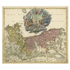
Antique Map of Europe Stretching from Northern Africa to the Baltic Sea, 1719
About the Item
Antique map titled 'Carte de la Germanie et les diferents Etats ou ses Peuples ont porté leurs conquestes'. Original antique map of Europe stretching from northern Africa to the Baltic Sea. It shows the locations of various royal dynasties including the Goths, the Lombards, the Ostrogoths, and the Visigoths, as well as the kings of France, Italy, and Spain. Numerous keys identify the principal towns and states and a lengthy set of tables list all the various European kings in chronological order. This map originates from 'Atlas Historique (..)' published 1719.
Artists and Engravers: Henri Abraham Chatelain (1684-1743), his father Zacharie Chatelain (d.1723) and Zacharie Junior (1690-1754), worked as a partnership publishing the Atlas Historique, Ou Nouvelle Introduction A L'Histoire under several different Chatelain imprints, depending on the Chatelain family partnerships at the time of publication.
Condition: Good, general age-related toning. Original folding line, minor wear. Blank verso, please study image carefully.
Date: 1719
Overall size: 51.5 x 44.5 cm.
Image size: 44 x 34 cm.
- Dimensions:Height: 17.52 in (44.5 cm)Width: 20.28 in (51.5 cm)Depth: 0 in (0.01 mm)
- Materials and Techniques:
- Period:
- Date of Manufacture:1719
- Condition:
- Seller Location:Langweer, NL
- Reference Number:
About the Seller
5.0
Platinum Seller
These expertly vetted sellers are 1stDibs' most experienced sellers and are rated highest by our customers.
Established in 2009
1stDibs seller since 2017
1,948 sales on 1stDibs
Typical response time: <1 hour
- ShippingRetrieving quote...Ships From: Langweer, Netherlands
- Return PolicyA return for this item may be initiated within 14 days of delivery.
More From This SellerView All
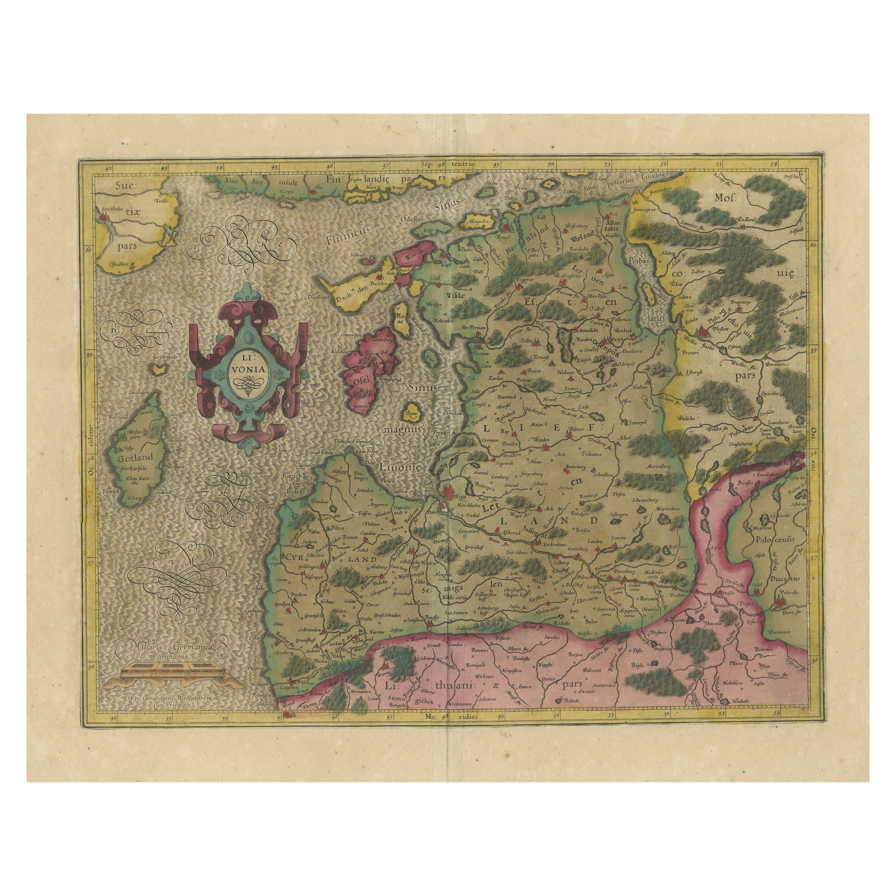
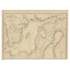
- Original Antique Map of the Northern Baltic RegionLocated in Langweer, NLTitle: "Livonia: Antique Map of the Northern Baltic Region" Description: This antique map, titled "Livonia," is a detailed representation of the northern Baltic region. Centered on ...Category
Antique Early 17th Century Maps
MaterialsPaper
- Antique Map of the Northern Coast of Africa and Southern Europe, circa 1745By Covens & MortierLocated in Langweer, NLAntique map titled 'In Notitiam Ecclesiasticam Africae Tabula Geographica'. Very decorative hand-colored map of the northern coast of Africa, Spain, Italy and the Mediterranean with the islands of Sardinia, Corsica, Majorca, Minorca etc. Sicily features a smoking Mount Aetna. Embellished with three architectural cartouches...Category
Antique Mid-18th Century Maps
MaterialsPaper
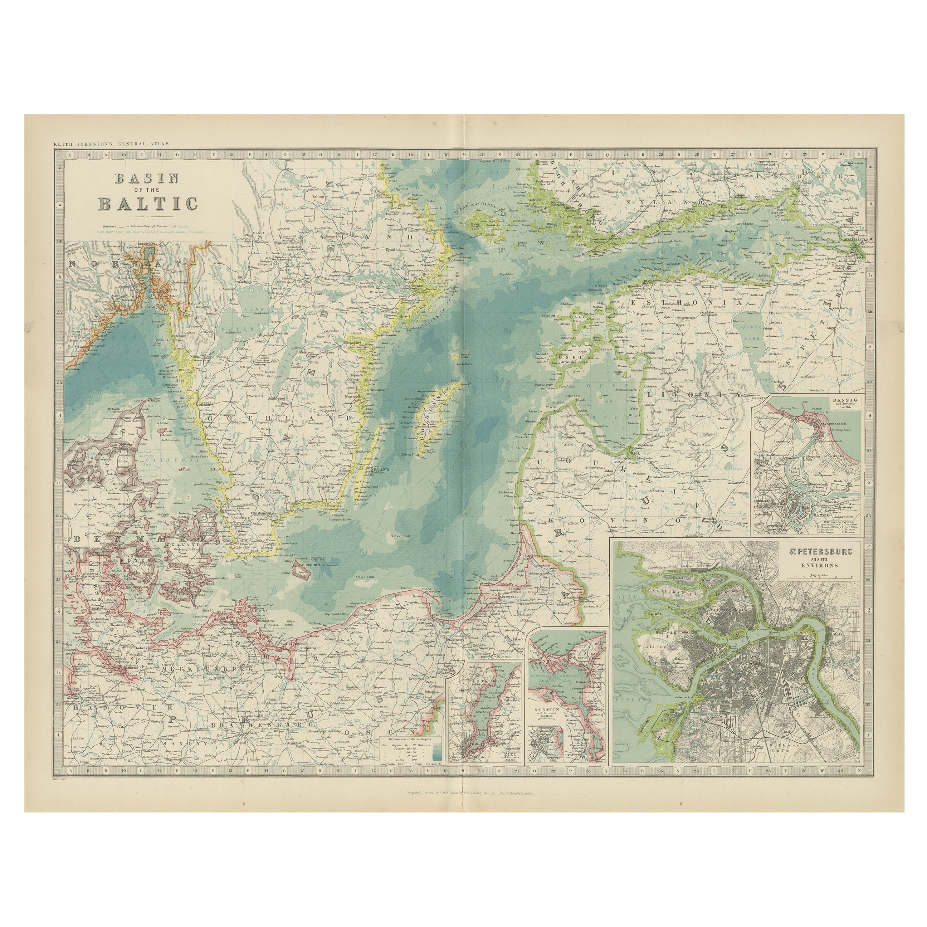
- Antique Map of the Baltic Sea by Johnston, '1909'Located in Langweer, NLAntique map titled 'Basin of the Baltic'. Original antique map of Baltic Sea. With inset maps of Kiel, Stettin, Danzig and St Petersburg. This map originate...Category
Early 20th Century Maps
MaterialsPaper
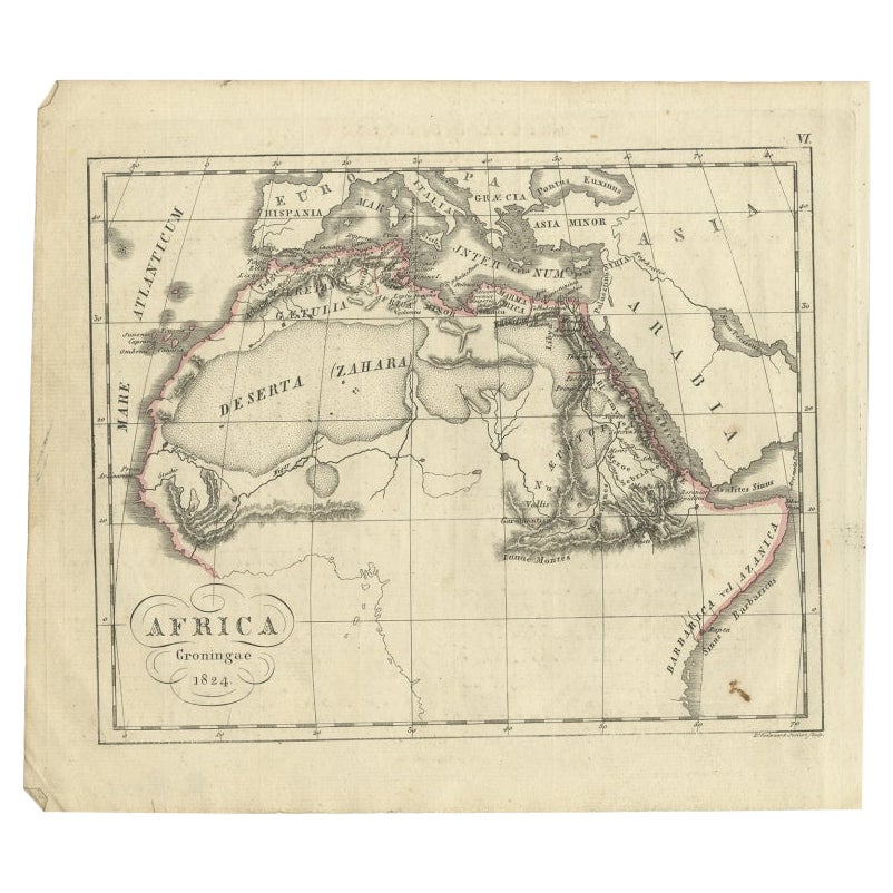
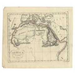
- Antique Map of Northern Africa from a Rare Dutch Atlas, 1825Located in Langweer, NLAntique map titled 'Africa'. Old map of the African continent originating from 'Atlas der Oude Wereld'. Artists and Engravers: Published by C. Ph. Funke and W. van Boekeren, Gron...Category
Antique 19th Century Maps
MaterialsPaper
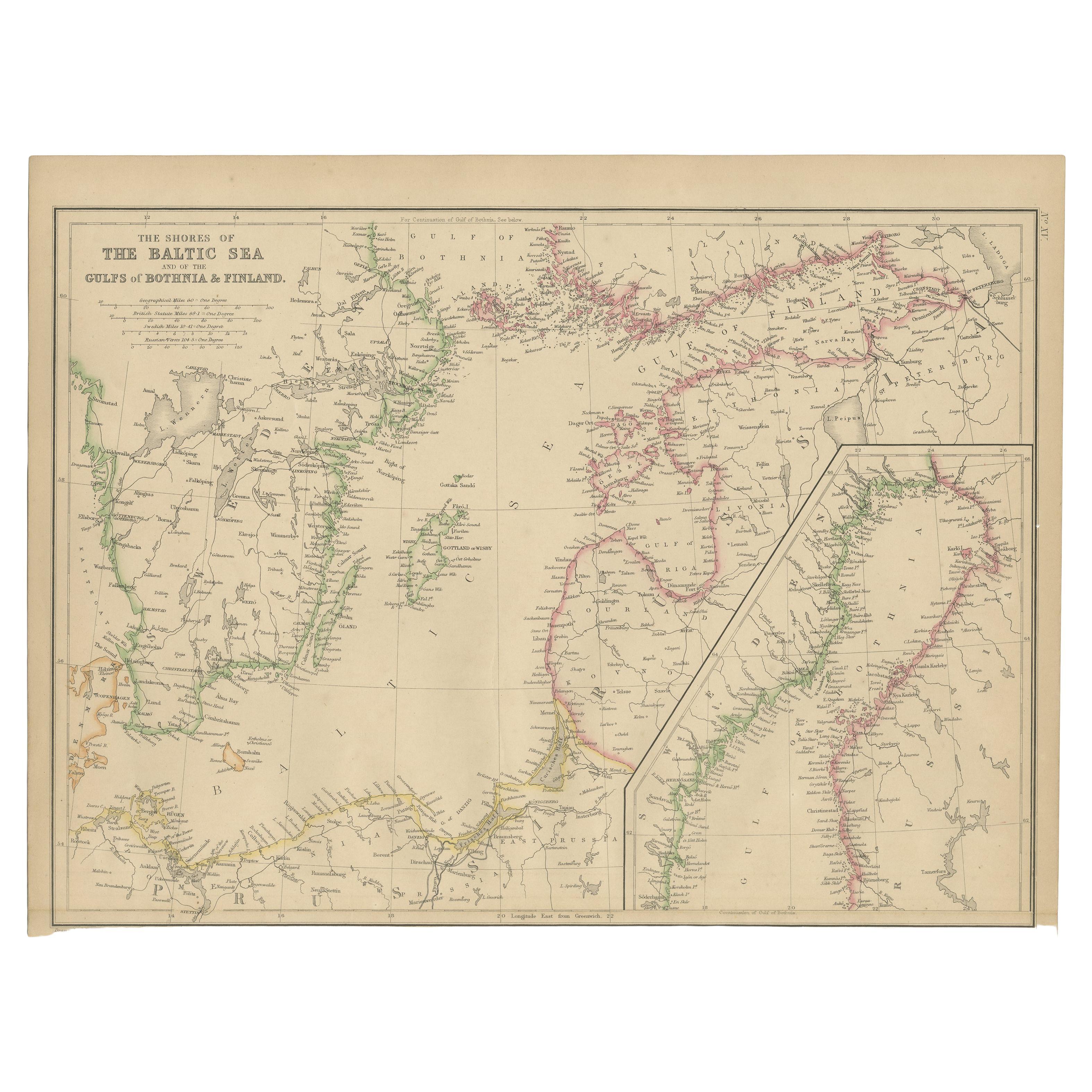
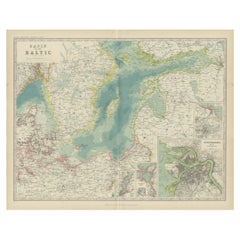
- Antique Map of the Shores of The Baltic Sea by W. G. Blackie, 1859Located in Langweer, NLAntique map titled 'The shores of The Baltic sea and of the Gulfs of Bothnia & Finland'. Original antique map of the Shores of the Baltic Sea. This map originates from ‘The Imperial ...Category
Antique Mid-19th Century Maps
MaterialsPaper
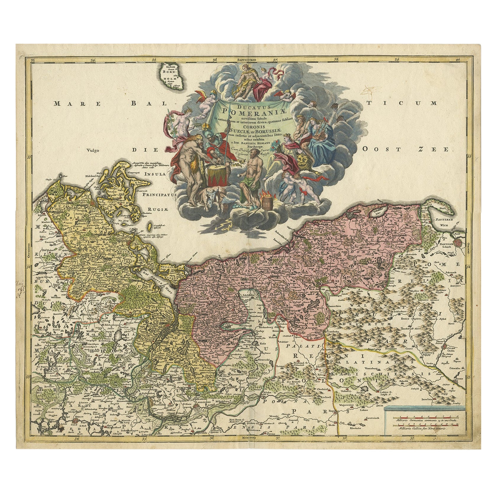
- Regional Antique Map of the Baltic, Extending from Stralsund to Dantzig, ca.1720Located in Langweer, NLAntique map titled 'Ducatus Pomeraniae (..)'. Regional map of the Baltic, extending from Stralsund and Rugia in the west to Dantzig and Culman on the Vistula in the east. Large carto...Category
Antique 1720s Maps
MaterialsPaper


You May Also Like
- Hand-Colored 18th Century Homann Map of Denmark and Islands in the Baltic SeaBy Johann Baptist HomannLocated in Alamo, CAAn 18th century copper plate hand-colored map entitled "Insulae Danicae in Mari Balthico Sitae utpote Zeelandia, Fionia, Langelandia, Lalandia, Falstria, Fembria Mona" created by Joh...Category
Antique Early 18th Century German Maps
MaterialsPaper
- Original Antique Map of Europe, Arrowsmith, 1820Located in St Annes, LancashireGreat map of Europe Drawn under the direction of Arrowsmith. Copper-plate engraving. Published by Longman, Hurst, Rees, Orme and Brown, 1820 ...Category
Antique 1820s English Maps
MaterialsPaper
- Original Antique Map of South Africa, Arrowsmith, 1820Located in St Annes, LancashireGreat map of South Africa. Drawn under the direction of Arrowsmith. Copper-plate engraving. Published by Longman, Hurst, Rees, Orme and Br...Category
Antique 1820s English Maps
MaterialsPaper
- New Map of North America from the Latest Discoveries, 1763Located in Philadelphia, PAA fine antique 18th century map of the North American seaboard. Entitled "A New Map of North America from the Latest Discoveries 1763". By the Cartographer/Engraver - John Spil...Category
Antique Mid-18th Century English Georgian Maps
MaterialsPaper
- Vintage "View of the Center of Paris Taken from the Air" Lithograph MapLocated in San Diego, CAA very stylish "View of the Center of Paris Taken from the Air" lithograph map published by the Paris Ministry of Tourism, circa early 1950s. The piece measures 27" x 43" and shows...Category
20th Century French Mid-Century Modern Prints
MaterialsPaper
- Map of the Republic of GenoaLocated in New York, NYFramed antique hand-coloured map of the Republic of Genoa including the duchies of Mantua, Modena, and Parma. Europe, late 18th century. Dimension: 25...Category
Antique Late 18th Century European Maps


Recently Viewed
View AllMore Ways To Browse
Northern French Furniture
Collecting Antique Keys
Keys Collectible Antique
Antique Maps Europe Maps
Antique Maps Of Europe
Map Spain
Maps Spain
Map Of Spain
18th Century African
Antique Sea Maps
Antique Sea Map
Sea Map
Antique Map Europe
Antique Map Of Europe
Africa Map Antique
Antique Africa Maps
Antique African Maps
Antique Africa Map