Items Similar to Original Antique Map of the Northern Baltic Region


Want more images or videos?
Request additional images or videos from the seller
1 of 6
Original Antique Map of the Northern Baltic Region
About the Item
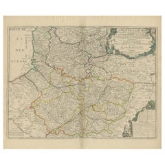
Title: "Livonia: Antique Map of the Northern Baltic Region"
Description: This antique map, titled "Livonia," is a detailed representation of the northern Baltic region. Centered on Riga, it encompasses a vast area extending from the southern regions, including Memel and parts of Poland and Russia, to the northern Strait between Finland and Latvia. Notably, Stockholm and Gotland are also featured on the map. Published by the renowned cartographer Gerardus Mercator circa 1620, this map offers valuable insights into the geographical knowledge of the time and is a historical document of the northern Baltic area during the 17th century.
- Dimensions:Height: 18.98 in (48.2 cm)Width: 23.15 in (58.8 cm)Depth: 0.02 in (0.5 mm)
- Materials and Techniques:
- Period:Early 17th Century
- Date of Manufacture:circa 1620
- Condition:Original/contemporary hand coloring. Original folding line, with a few small splits. Age-related toning, shows wear and soiling. Tape residu in both margins. French text on verso. Please study image carefully.
- Seller Location:Langweer, NL
- Reference Number:
About the Seller
5.0
Platinum Seller
These expertly vetted sellers are 1stDibs' most experienced sellers and are rated highest by our customers.
Established in 2009
1stDibs seller since 2017
1,919 sales on 1stDibs
Typical response time: <1 hour
- ShippingRetrieving quote...Ships From: Langweer, Netherlands
- Return PolicyA return for this item may be initiated within 14 days of delivery.
More From This SellerView All
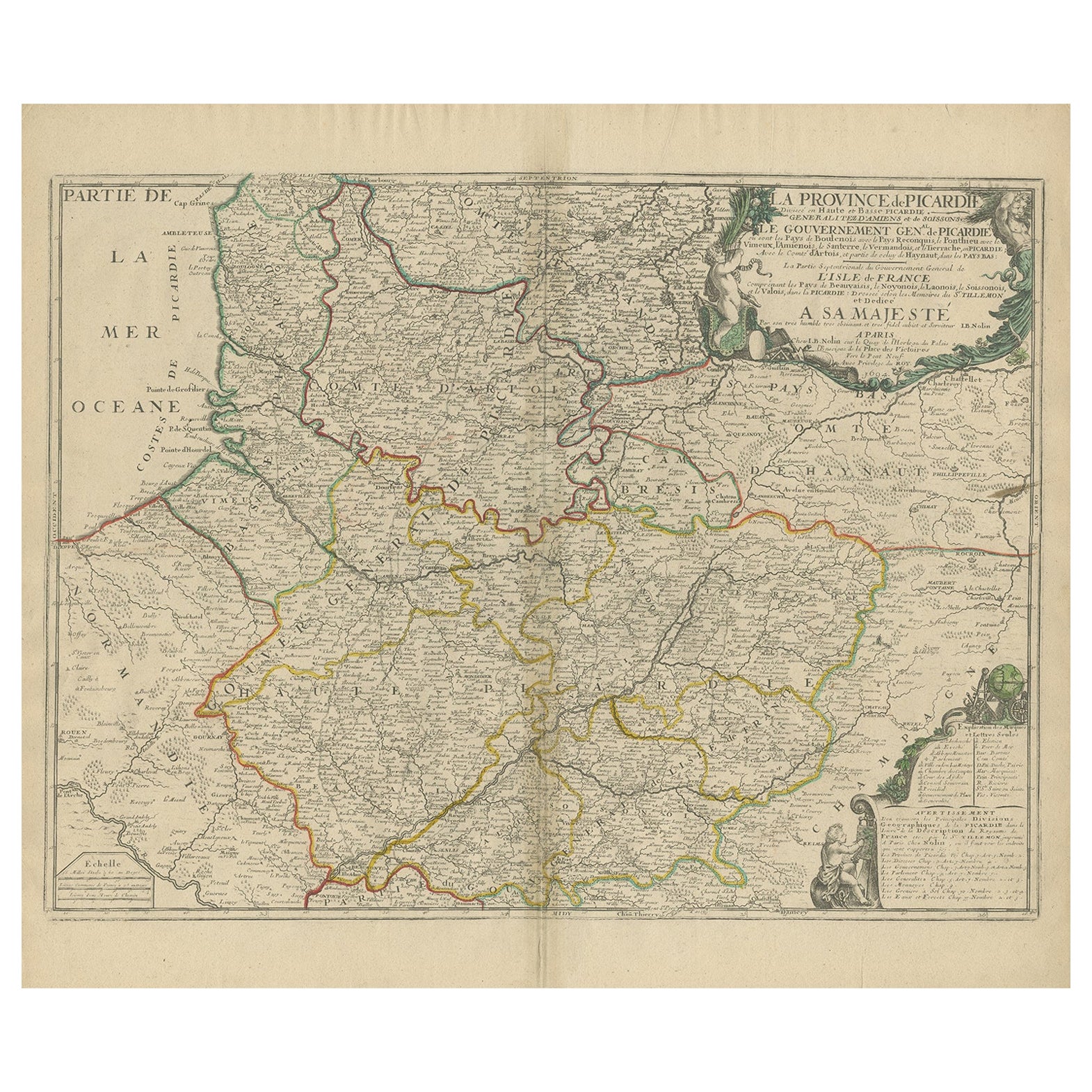
- Original Antique Map of the Picardy Region in Northern France, 1694Located in Langweer, NLAntique map titled 'La Province de Picardie (..)'. Large map of the Picardy region of France. Shows the cities of Beaumont, Mondidier, Lille and others. Artists and Engravers: Je...Category
Antique 17th Century Maps
MaterialsPaper
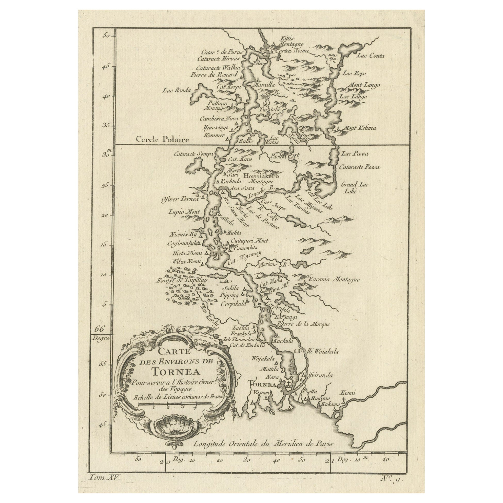
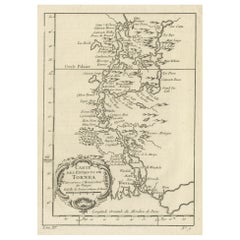
- Original Antique Map of the Region of Torneå 'Tornio' in Northern Finland, 1759Located in Langweer, NLAntique map titled 'Carte des Environs de Tornea'. Original antique map of the region of Torneå (or Tornio), in northern Finland. This print originates from volume 19 of 'Histoir...Category
Antique 1750s Maps
MaterialsPaper
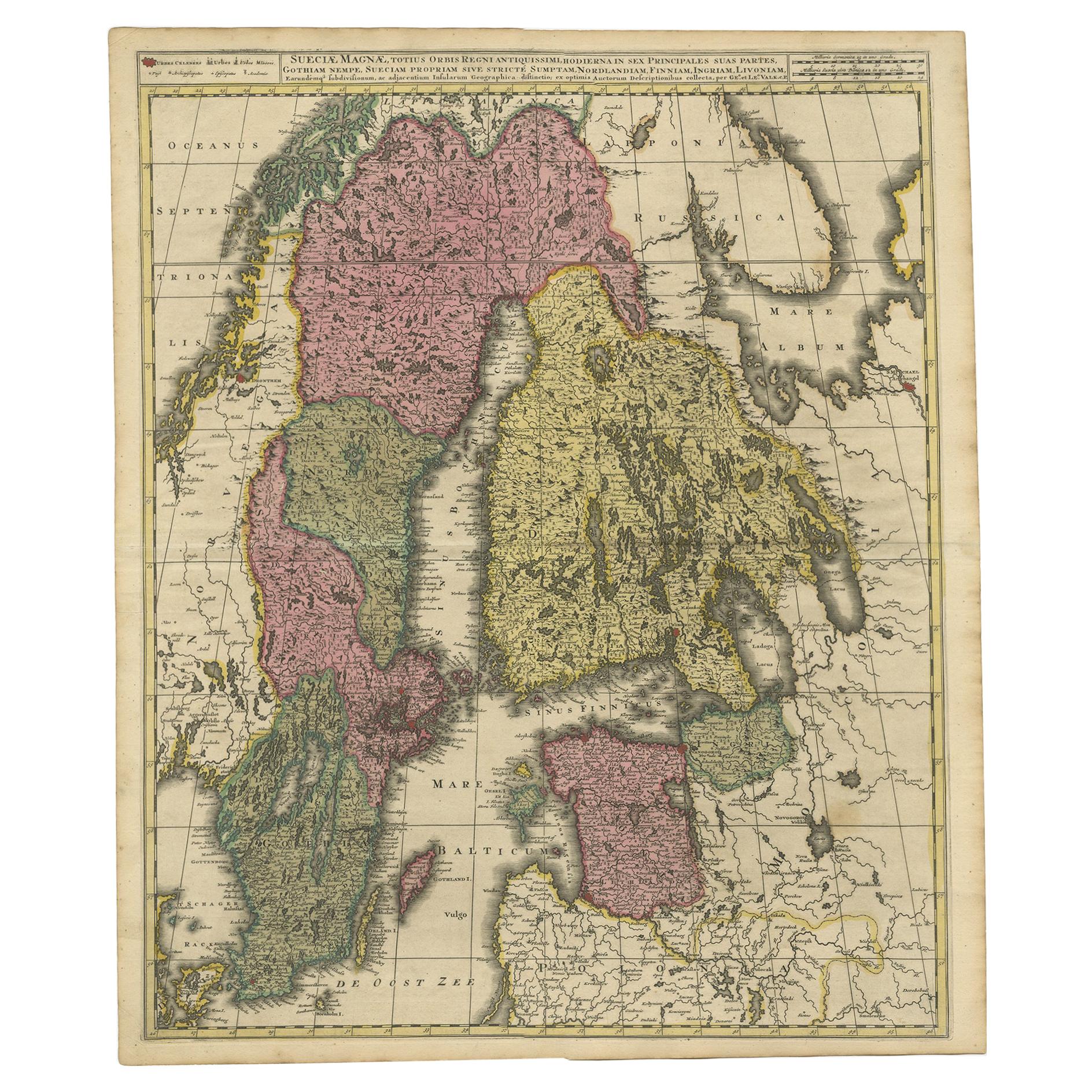
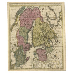
- Antique Map of Scandinavia and the Baltic Region by Valk, circa 1690Located in Langweer, NLAntique map titled 'Sueciae Magnae, totius orbis regni antiquissimi (..)'. Map of Scandinavia and the Baltic region. It shows Norway, Sweden, Finla...Category
Antique Late 17th Century Maps
MaterialsPaper
- Original Antique Map of Northern IndiaBy Jakob van der SchleyLocated in Langweer, NLAntique map titled 'Carte de l'Indoustan (..) - Kaart van Hindoestan (..)'. Original antique map of northern India. This map originates from 'His...Category
Antique Mid-18th Century Maps
MaterialsPaper
- Antique Map of Europe Stretching from Northern Africa to the Baltic Sea, 1719Located in Langweer, NLAntique map titled 'Carte de la Germanie et les diferents Etats ou ses Peuples ont porté leurs conquestes'. Original antique map of Europe stretching from northern Africa to the Balt...Category
Antique 18th Century Maps
MaterialsPaper
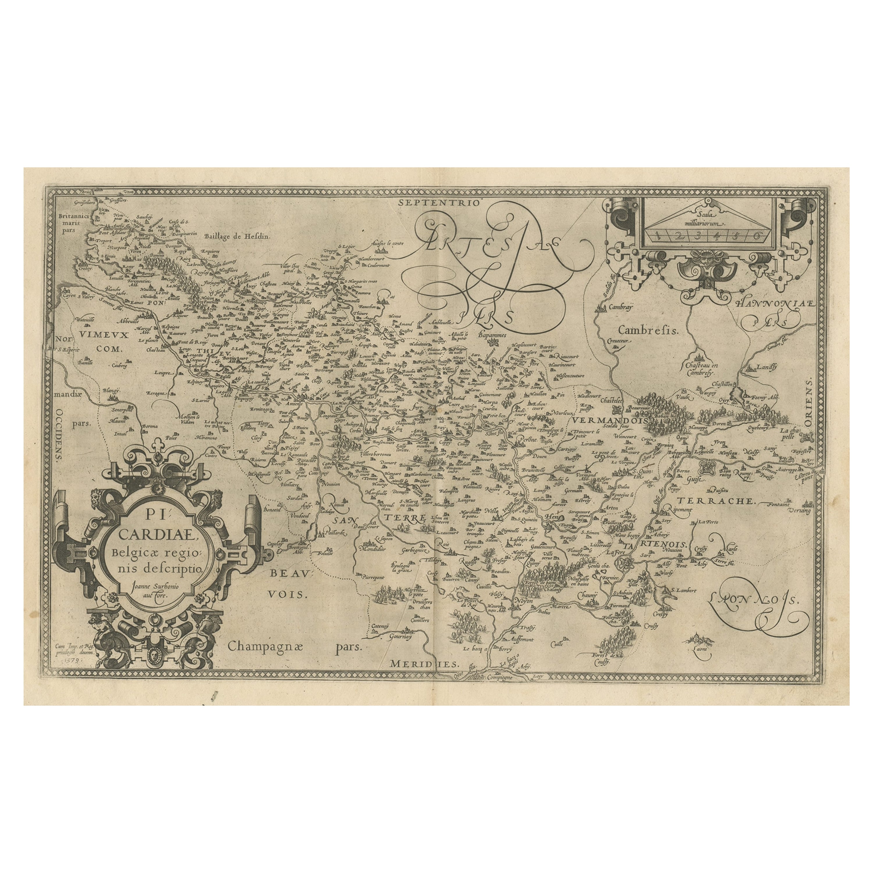
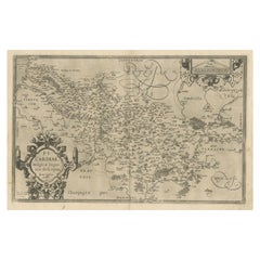
- Original Antique Map of the Region of Picardy, France, ca.1602Located in Langweer, NLAntique map titled 'Picardiae Belgicae regionis descriptio'. Original antique map of the region of Picardy, France. Superb example of the decorative style of Ortelius and filled ...Category
Antique Early 1600s Maps
MaterialsPaper


You May Also Like
- Original Antique Map of Italy. C.1780Located in St Annes, LancashireGreat map of Italy Copper-plate engraving Published C.1780 Unframed.Category
Antique Early 1800s English Georgian Maps
MaterialsPaper

- Original Antique Map of Asia. C.1780Located in St Annes, LancashireGreat map of Asia Copper-plate engraving Published C.1780 Two small worm holes to right side of map Unframed.Category
Antique Early 1800s English Georgian Maps
MaterialsPaper

- Original Antique Map of India. C.1780Located in St Annes, LancashireGreat map of India Copper-plate engraving Published C.1780 Three small worm holes to right side of map and one bottom left corner Unframed.Category
Antique Early 1800s English Georgian Maps
MaterialsPaper

- Original Antique Map of The World by Thomas Clerk, 1817Located in St Annes, LancashireGreat map of The Eastern and Western Hemispheres On 2 sheets Copper-plate engraving Drawn and engraved by Thomas Clerk, Edinburgh. Published by Mackenzie And Dent, 1817 ...Category
Antique 1810s English Maps
MaterialsPaper
- Original Antique Map of Italy. Arrowsmith. 1820Located in St Annes, LancashireGreat map of Italy Drawn under the direction of Arrowsmith Copper-plate engraving Published by Longman, Hurst, Rees, Orme and Brown, 1820 Unframed.Category
Antique 1820s English Maps
MaterialsPaper
- Original Antique Map of South America. C.1780Located in St Annes, LancashireGreat map of South America Copper-plate engraving Published C.1780 Two small worm holes to left side of map Unframed.Category
Antique Early 1800s English Georgian Maps
MaterialsPaper


Recently Viewed
View AllMore Ways To Browse
Antique Map Livonia
Livonia Map
Antique Map Bahamas
Antique Map Ontario
Antique Maps Ontario
Map Lebanon
Antique Map Montreal
Antique Maps San Diego
Lebanon Antique Map
Montreal Map
Antique Furniture Perth Australia
Antique Maps Perth
Barbados Map
Antique Map Connecticut
Antique Map Of Republic Of Texas
Antique Route 66
Giovanni Maria Cassini On Sale
Antique Map Cleveland