Items Similar to 17th-Century Map of the Latin Patriarchate of Jerusalem by Melchior Tavernier

Want more images or videos?
Request additional images or videos from the seller
1 of 6
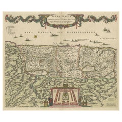
17th-Century Map of the Latin Patriarchate of Jerusalem by Melchior Tavernier
$863.41
£642.29
€720
CA$1,182.30
A$1,314.56
CHF 686.39
MX$16,001.38
NOK 8,758.04
SEK 8,205.86
DKK 5,480.96
Shipping
Retrieving quote...The 1stDibs Promise:
Authenticity Guarantee,
Money-Back Guarantee,
24-Hour Cancellation
About the Item
Title: 17th-Century Map of the Latin Patriarchate of Jerusalem by Melchior Tavernier
Description: This rare 17th-century map by Melchior Tavernier illustrates the geographical extent of the Latin Patriarchate of Jerusalem during the Crusader period. The map focuses on the Holy Land, with divisions representing the Patriarchate and its suffragan dioceses, including the archdioceses of Tyre, Caesarea, Nazareth, and Petra. Key biblical locations, such as Jerusalem, Bethlehem, Gaza, and Hebron, are meticulously detailed. The ornate cartouche reflects Tavernier’s artistic style, blending geographical accuracy with decorative elegance.
Historically, the Latin Patriarchate was established in 1099 after the Crusaders captured Jerusalem. It marked a significant ecclesiastical reorganization, with a Latin hierarchy replacing the Orthodox Patriarchate. This map captures the period's territorial divisions, reflecting the Crusader influence in the Holy Land.
Condition report: The map is in excellent condition, with clear engraving and vibrant original hand-coloring. Minor toning and slight foxing are visible in the margins, but they do not detract from the overall image.
Framing tip: Use archival-quality matting and UV-protective glass to preserve its condition. A dark wooden or gilded frame will highlight the map’s historic and decorative features, making it a standout piece in any collection or display.
This map is a remarkable artifact, combining Tavernier’s cartographic skill with the historical significance of the Crusader period in the Holy Land. A valuable addition for collectors of early cartography or religious history.
- Dimensions:Height: 17.33 in (44 cm)Width: 22.84 in (58 cm)Depth: 0.01 in (0.2 mm)
- Materials and Techniques:Paper,Engraved
- Period:1640-1649
- Date of Manufacture:circa 1640
- Condition:Condition report: The map is in excellent condition, with clear engraving and vibrant original hand-coloring. Minor toning and slight foxing are visible in the margins, but they do not detract from the overall image. Folding line as issued.
- Seller Location:Langweer, NL
- Reference Number:Seller: BG-14042-11stDibs: LU3054343394372
About the Seller
5.0
Recognized Seller
These prestigious sellers are industry leaders and represent the highest echelon for item quality and design.
Platinum Seller
Premium sellers with a 4.7+ rating and 24-hour response times
Established in 2009
1stDibs seller since 2017
2,510 sales on 1stDibs
Typical response time: <1 hour
- ShippingRetrieving quote...Shipping from: Langweer, Netherlands
- Return Policy
Authenticity Guarantee
In the unlikely event there’s an issue with an item’s authenticity, contact us within 1 year for a full refund. DetailsMoney-Back Guarantee
If your item is not as described, is damaged in transit, or does not arrive, contact us within 7 days for a full refund. Details24-Hour Cancellation
You have a 24-hour grace period in which to reconsider your purchase, with no questions asked.Vetted Professional Sellers
Our world-class sellers must adhere to strict standards for service and quality, maintaining the integrity of our listings.Price-Match Guarantee
If you find that a seller listed the same item for a lower price elsewhere, we’ll match it.Trusted Global Delivery
Our best-in-class carrier network provides specialized shipping options worldwide, including custom delivery.More From This Seller
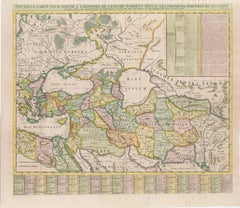
View All18th-Century Map of the Eastern Roman Empire by Henri Chatelain, c. 1719
Located in Langweer, NL
Title: 18th-Century Map of the Eastern Roman Empire by Henri Chatelain, c. 1719
Description: This intricately detailed map, titled *Nouvelle Carte pour Servir à l'Histoire de l'Empi...
Category
Antique 1710s Maps
Materials
Paper
Antique Map of the Holy Land Described in the Old and New Testament, ca.1660
Located in Langweer, NL
Antique map titled 'Geographiae Sacrae ex Veteri et Novo Testamento Desumptae Tabula Prima quae Totius Orbis Partes Continet.'
Map of the lands described in the Old and New Testame...
Category
Antique 1660s Maps
Materials
Paper

$815 Sale Price
20% Off
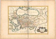
1667 Melchior Tavernier Map of the Patriarchate of Constantinople – Black Sea, G
Located in Langweer, NL
This 1667 map titled "Patriarchatus Constantinopolitani Geographica Descriptio" was crafted by renowned French cartographer Melchior Tavernier, who was a prominent map engraver during the 17th century. This rare and historically significant map focuses on the territories under the ecclesiastical jurisdiction of the Patriarchate of Constantinople, one of the most important centers of the Eastern Orthodox Church.
It covers regions around the Black Sea (Pontus Euxinus), parts of Greece, and adjacent areas in Asia Minor and the Balkans, which were historically vital during the Byzantine and Ottoman Empires. The map is filled with ancient place names, making it a valuable resource for both historical and cartographic enthusiasts.
Key Features:
- Antique ecclesiastical map illustrating the influence of the Orthodox Patriarchate of Constantinople in the 17th century.
- Features beautifully detailed ancient coastlines, rivers, and terrains, providing a comprehensive geographical view of the region.
- Rich with historic place names - like Byzantium, Nicomedia, Nicaea, Cyzicus, Bithynia, Pontus, Macedonia, and Thrace - that date back to the classical era, offering insights into the ancient geography of the eastern Mediterranean.
- A finely engraved strapwork cartouche in the lower right corner with Baroque-style decoration, featuring two putti (cherubic figures) – a hallmark of 17th-century map art.
- The map extends to include the Mediterranean Sea (Mare Mediterraneum) to the south and the Black Sea to the north, highlighting its ecclesiastical and geopolitical significance.
- Original hand coloring may still be present, enhancing the decorative appeal for collectors of antique maps.
This rare map offers a unique perspective on the religious influence and historical geography of the Eastern Mediterranean during the late 17th century. It would appeal to collectors interested in:
- **Byzantine history**
- **Ottoman Empire**
- **Eastern Orthodox Church**
- **Antique cartography...
Category
Antique 1660s Maps
Materials
Paper
$748 Sale Price
20% Off
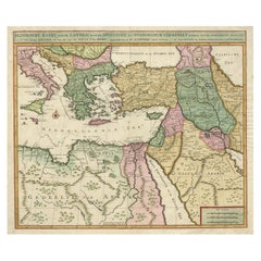
Highly Decorative Map of The Eastern Mediterranean and The Middle East, ca.1700
Located in Langweer, NL
Antique map titled 'Byzondere Kaart van de Landen Daar de Apostelen Het Evangelium Gepredikt Hebben (..).'
Highly decorative map of the eastern Mediterranean...
Category
Antique Early 1700s Maps
Materials
Paper
$911 Sale Price
20% Off
Free Shipping
Frederic de Wit Map of Palestine – Terra Sancta, Amsterdam c.1670
Located in Langweer, NL
Terra Sancta sive Promissionis, olim Palestina – hand-coloured copper-engraved map of the Holy Land by Frederic de Wit, Amsterdam, circa 1670
This impressive folio sheet, bearing th...
Category
Antique Late 17th Century Dutch Maps
Materials
Paper
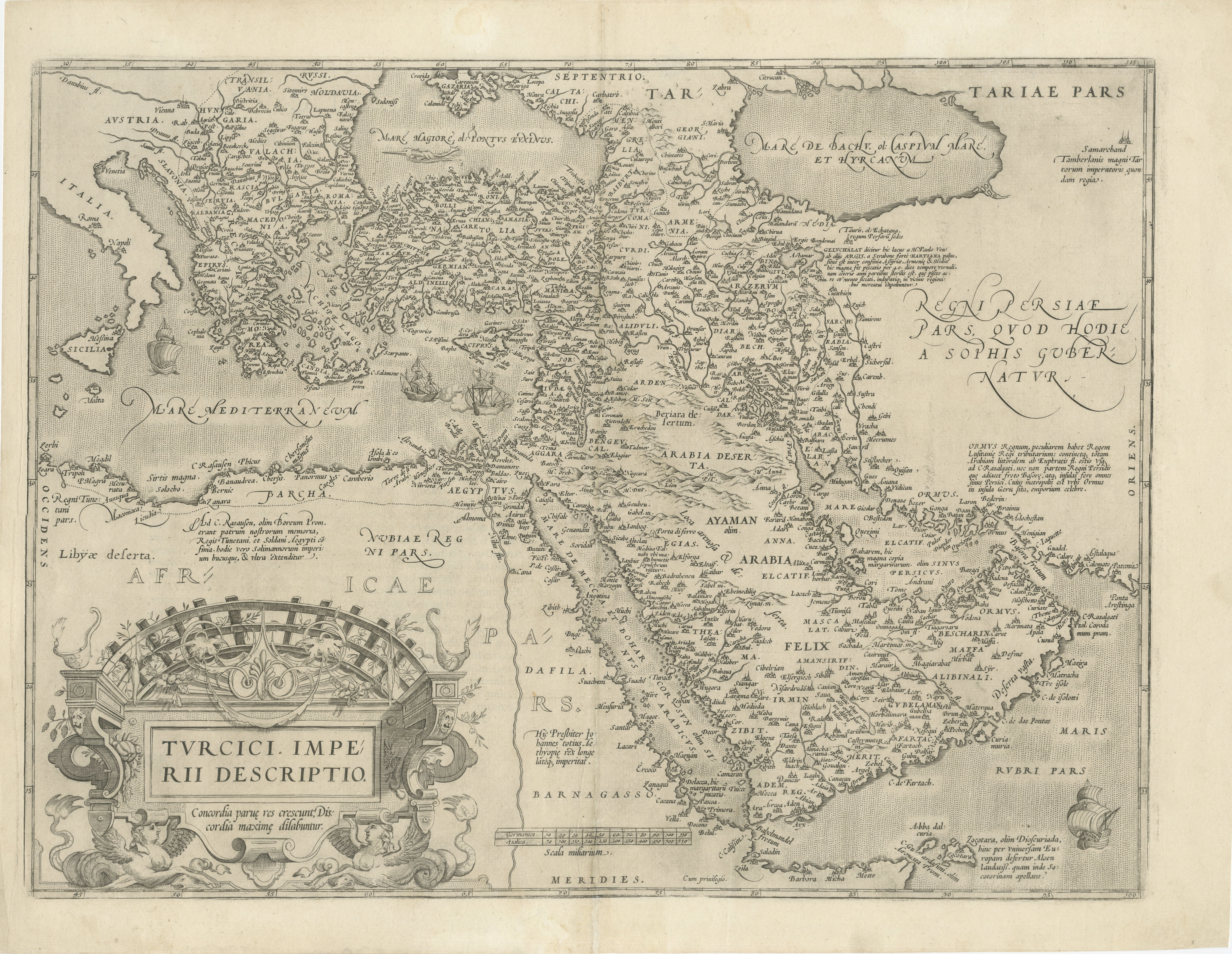
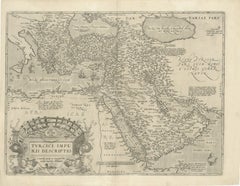
16th-Century Map of the Ottoman Empire and Near East: Turcici Imperii Descriptio
Located in Langweer, NL
Title: Original 16th-Century Map of the Ottoman Empire and Near East: *Turcici Imperii Descriptio* by Ortelius, 1571
This rare copperplate engraving, Turcici Imperii Descriptio, i...
Category
Antique 16th Century Maps
Materials
Paper
You May Also Like
Southern Greece: A Large 17th Century Hand-colored Map By Sanson and Jaillot
By Nicholas Sanson d'Abbeville
Located in Alamo, CA
This large original hand-colored copperplate engraved map of southern Greece and the Pelopponese Peninsula entitled "La Moree Et Les Isles De Zante, Cefalonie, Ste. Marie, Cerigo & C...
Category
1690s Landscape Prints
Materials
Engraving

Southern Greece: A Large 17th C. Hand-colored Map by Sanson and Jaillot
By Nicolas Sanson
Located in Alamo, CA
This large original hand-colored copperplate engraved map of southern Greece and the Pelopponese Peninsula entitled "La Moree Et Les Isles De Zante, Cefalonie, Ste. Marie, Cerigo & C...
Category
Antique 1690s French Maps
Materials
Paper

Southern & Eastern Europe: A Large 17th C. Hand-colored Map by Sanson & Jaillot
By Nicolas Sanson
Located in Alamo, CA
This large hand-colored map entitled "Estats de L'Empire des Turqs en Europe, ou sont les Beglerbeglicz our Gouvernements" was originally created by Nicholas Sanson d'Abbeville and t...
Category
Antique 1690s French Maps
Materials
Paper

"Nova Barbariae Descriptio", a 17th Century Hand-Colored Map of North Africa
By Johannes Janssonius
Located in Alamo, CA
This original attractive 17th century hand-colored map of North Africa entitled "Nova Barbariae Descriptio" by Johannes Janssonius was published in Paris in 1635. It includes the Med...
Category
Antique Mid-17th Century Dutch Maps
Materials
Paper

17th Century Dutch Map of the Holy Land at the Time of Jesus by Visscher
By Nicolaus Visscher
Located in Alamo, CA
This detailed Dutch map entitled "Het Beloofe de Landt Canaan door wandelt van onsen Salichmaecker Iesu Christo, nessens syne Apostelen" by Nicolaes Visscher (1610-1679), published i...
Category
1660s Prints and Multiples
Materials
Engraving

Southern & Eastern Europe: A Large 17th C. Hand-colored Map by Sanson & Jaillot
By Nicholas Sanson d'Abbeville
Located in Alamo, CA
This large hand-colored map entitled "Estats de L'Empire des Turqs en Europe, ou sont les Beglerbeglicz our Gouvernements" was originally created by Nicholas Sanson d'Abbeville and this version was published by Hubert Jaillot in "Atlas Nouveau" in Paris in 1692. It depicts the territories of the Ottoman Empire in Europe, predominantly Eastern Europe. Highlights include, the Mediterranean Sea, the Adriatic Sea, the Black Sea, the Dalmation Coast including present day Croatia, Bosnia and Herzegovina, Montenegro, Serbia, Slovenia, Italy, Greece, North Macedonia, Turkey, Romania, Hungary, Albania, Kosovo, Bulgaria, Transylvania, Moldova and southern portions of France, Switzerland, Germany, and Poland..
The map consists of two sheets joined as one along a vertical joint. The map has original hand-coloring. It is printed on antique hand-made laid, chain-linked paper with wide margins. The sheet measures 24.88" high and 38" wide. There is a central vertical joint, as issued. The map is in very good condition.
Nicholas Sanson d'Abbeville (1600-1667) was one of the greatest French cartographather of French cartography. Sanson opened his first printing business in Paris in 1638. The king recognized his skill and knowledge and made him the official geographer to the court. He eventually served two kings in this capacity. Sanson was succeeded by his sons and son...
Category
1690s Landscape Prints
Materials
Engraving

More Ways To Browse
Jerusalem Furniture
Used Tyre Furniture
Carlo Scarpa 1934 Chairs
Christofle Marly
1900 Antique Chairs
Glass Table Italian Round
Alvar Aalto Poster
Geometric Metal Table
Post Modern High Chairs
Vintage Vine Rug
Cancel An Order
Antique Framing Square
Silver Metal Chair
Swedish Kilim
Vintage Scandanavian Chairs
Vintage Tropical Furniture
19th Century Red Glass
Antique French Console Table Tables