Items Similar to 17th Century Nautical Chart of Skagerrak and Øresund by Johannes van Keulen

Want more images or videos?
Request additional images or videos from the seller
1 of 11
17th Century Nautical Chart of Skagerrak and Øresund by Johannes van Keulen
$920.17
$1,150.2220% Off
£684.88
£856.1020% Off
€768
€96020% Off
CA$1,260.41
CA$1,575.5120% Off
A$1,401.85
A$1,752.3120% Off
CHF 732
CHF 91520% Off
MX$17,059.02
MX$21,323.7720% Off
NOK 9,348.79
NOK 11,685.9820% Off
SEK 8,767.51
SEK 10,959.3920% Off
DKK 5,846.52
DKK 7,308.1420% Off
Shipping
Retrieving quote...The 1stDibs Promise:
Authenticity Guarantee,
Money-Back Guarantee,
24-Hour Cancellation
About the Item
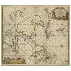
This map titled *Pascaret van Schager-Rack de Bælt en de Sondt* was created by the prominent Dutch cartographer Johannes van Keulen and published in Amsterdam during the late 17th century, around 1680. Johannes van Keulen was part of a renowned family of maritime cartographers and publishers, known for their contributions to nautical chart making during the Dutch Golden Age of exploration and trade.
This nautical chart focuses on the waters between Denmark and Sweden, specifically the Skagerrak, Kattegat, and Øresund straits. These strategic waterways were critical for European maritime navigation, as they provided access from the North Sea to the Baltic Sea, an essential trade route for the northern European powers. The map is detailed with numerous compass roses and rhumb lines, which helped navigators plot courses between various ports and islands in the region.
The ornate cartouches, featuring allegorical figures and maritime themes, are typical of van Keulen’s maps and add to the aesthetic and historical value of the piece. The map is not only a navigational tool but also a work of art, reflecting the sophistication of Dutch cartography in the 17th century.
What makes this map particularly interesting is its focus on a key maritime region during a time when European powers were vying for control of northern trade routes. The accuracy of the coastlines, along with the depiction of various hazards, islands, and depth soundings, makes it a valuable resource for understanding navigation and commerce in the North and Baltic Seas during the height of Dutch naval dominance.
In this map by Johannes van Keulen, there are typically two cartouches: a decorative title cartouche and an informational cartouche. These cartouches are often filled with allegorical figures and symbols, and they provide essential information about the map, including its title, dedication, and sometimes an acknowledgment of notable figures relevant to the region depicted.
In the title cartouche at the top left, the text reads:
'Pascaret van Schager-Rack de Bælt en de Sondt
Tusschen Noorwegen en Jutlandt, Soo verre als de Oost Zee
Door Johannes van Keulen tot Amsterdam, met Privilegie voor 15 Jaren'
Translation:
"Chart of the Skagerrak, the Belt, and the Sound
Between Norway and Jutland, extending as far as the Baltic Sea
By Johannes van Keulen, Amsterdam, with a 15-year privilege"
This cartouche provides the title of the map and indicates that van Keulen had exclusive publishing rights ("with privilege for 15 years") to this work, granted by the government.
The second cartouche, often located in the bottom right, contains a dedication. In this case, it references Cornelis Tromp. The text might read something like this:
'Translation of the second cartouche (approximate):'
"This map is dedicated to the honorable Cornelis Tromp, Lieutenant-Admiral of the Dutch fleet, whose prowess in the naval battles of the North Sea and the Baltic has been recognized."
Why is Tromp mentioned?
'Cornelis Tromp' was a highly regarded Dutch admiral during the Dutch Golden Age, known for his victories in naval battles, particularly against England during the Anglo-Dutch Wars and in conflicts involving Denmark and Sweden. The regions depicted in this map—the Skagerrak, Kattegat, and Øresund straits—were strategic naval areas where Tromp and the Dutch navy would have been highly active.
By dedicating the map to Tromp, van Keulen acknowledges the Admiral's importance in securing Dutch control and influence over these critical maritime routes. It’s also a way of honoring a national hero who had a major impact on the history of Dutch maritime dominance.
Conclusion:
The mention of Tromp emphasizes the Dutch naval prowess and historical importance of the waters shown in the map. This dedication adds a layer of historical significance to the map, connecting it to prominent naval figures of the 17th century.
Keywords:
Johannes van Keulen, Maarten Tromp, 17th-century Dutch cartography, nautical chart, Skagerrak, Kattegat, Øresund, North Sea navigation, Dutch maritime history, naval charts, Tromp naval battles, maritime routes, Johannes van Keulen map, 17th-century nautical chart, Skagerrak, Kattegat, Øresund, North Sea to Baltic Sea trade route, Dutch Golden Age cartography, historical maritime map, navigation chart, Denmark and Sweden maritime history.
This map would attract collectors of maritime history, enthusiasts of Dutch cartography, and those interested in the historical significance of Northern European trade routes. Its blend of artistry and utility makes it a standout piece from one of the most influential cartographers of the era.
The map appears to be in a fair to good antique condition*overall, but there are some signs of age, including a few tiny wormholes, that are typical for a map of this period. Based on the image:
- Paper Quality: The paper shows signs of natural aging, with a slight yellowing or toning typical of 17th-century maps. This is common for maps of this age and indicates its authenticity.
- Folds: The map has visible folds, which is normal for a chart of this size, as it would have been folded for storage or transport. The folds do not appear to have caused significant damage.
- Margins: The margins show signs of wear, including some minor edge damage and slight fraying, which is expected from handling over centuries.
- Print Quality: The engraving itself remains clear and well-defined, with no major fading of the ink. This suggests that the map has been well-preserved.
- Overall: There do not seem to be any major tears or significant losses, and the cartouches and details are still crisp and legible, making this map a valuable and well-preserved example of Johannes van Keulen's work.
In conclusion, despite minor signs of aging, this map remains in a collectible and displayable condition for its age and is likely considered a valuable historical artifact.
- Dimensions:Height: 21.07 in (53.5 cm)Width: 24.81 in (63 cm)Depth: 0 in (0.02 mm)
- Materials and Techniques:Paper,Engraved
- Period:Late 17th Century
- Date of Manufacture:circa 1680
- Condition:Repaired: Some old repairs on the reverse visible and the original map has been professionally backed to make it stronger. Condition: fair, given age. General age-related toning and minor defects from handling over the centuries. Small wormholes next to fold line in top and bottom (below image). Top margin cut short. Please study scan carefully.
- Seller Location:Langweer, NL
- Reference Number:Seller: BG-136551stDibs: LU3054341646962
About the Seller
5.0
Recognized Seller
These prestigious sellers are industry leaders and represent the highest echelon for item quality and design.
Platinum Seller
Premium sellers with a 4.7+ rating and 24-hour response times
Established in 2009
1stDibs seller since 2017
2,508 sales on 1stDibs
Typical response time: <1 hour
- ShippingRetrieving quote...Shipping from: Langweer, Netherlands
- Return Policy
Authenticity Guarantee
In the unlikely event there’s an issue with an item’s authenticity, contact us within 1 year for a full refund. DetailsMoney-Back Guarantee
If your item is not as described, is damaged in transit, or does not arrive, contact us within 7 days for a full refund. Details24-Hour Cancellation
You have a 24-hour grace period in which to reconsider your purchase, with no questions asked.Vetted Professional Sellers
Our world-class sellers must adhere to strict standards for service and quality, maintaining the integrity of our listings.Price-Match Guarantee
If you find that a seller listed the same item for a lower price elsewhere, we’ll match it.Trusted Global Delivery
Our best-in-class carrier network provides specialized shipping options worldwide, including custom delivery.More From This Seller
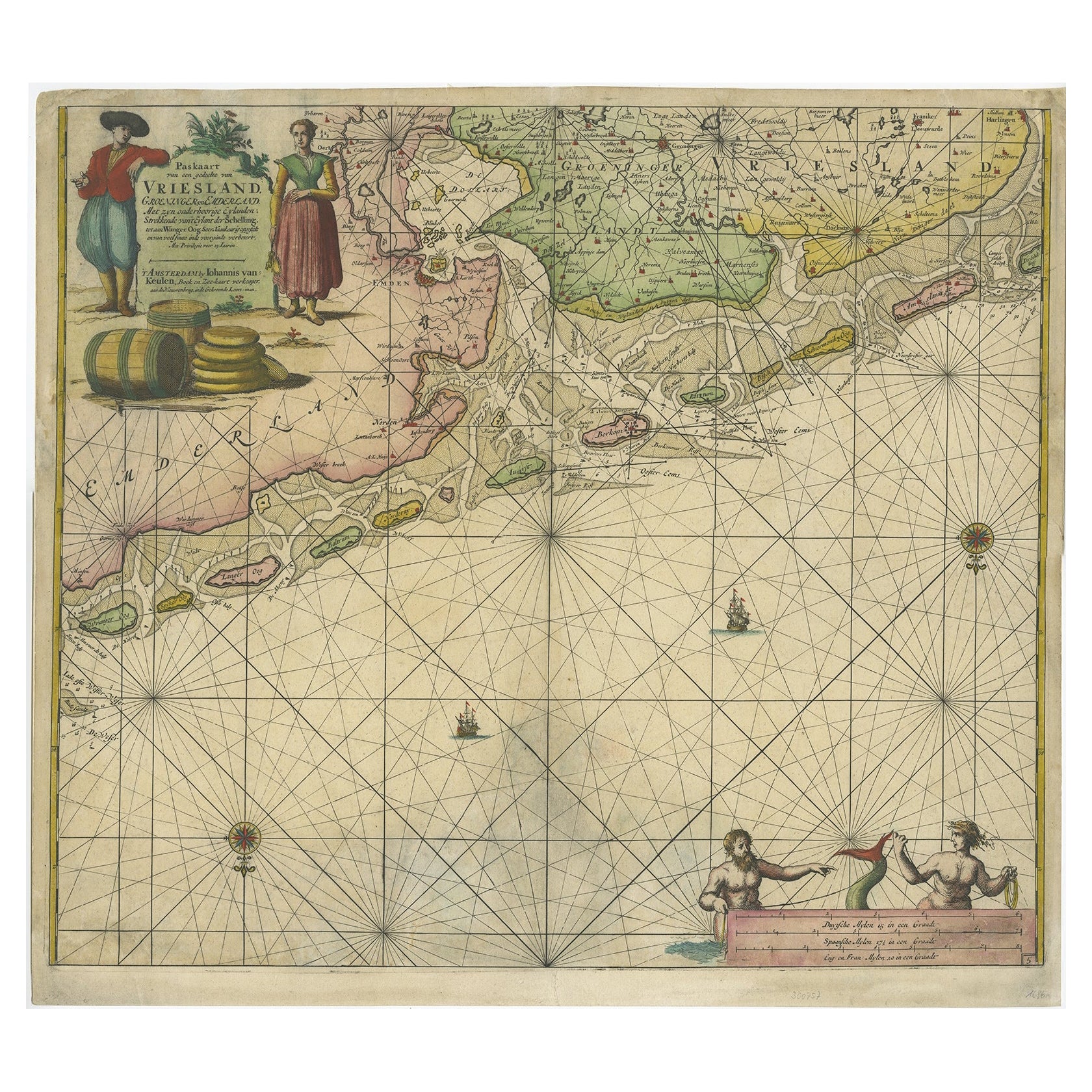
View AllOld Decorative & Highly Detailed Sea Chart of the North Dutch-German Coast, 1681
Located in Langweer, NL
Antique map titled 'Paskaart van een gedeelte van Vriesland, Groeninger, en Emderland. Met zyn onderhoorige Eylanden; Strekkende van't Eylant der Schelling'.
Decorative and highl...
Category
Antique 1680s Maps
Materials
Paper
$1,581 Sale Price
20% Off
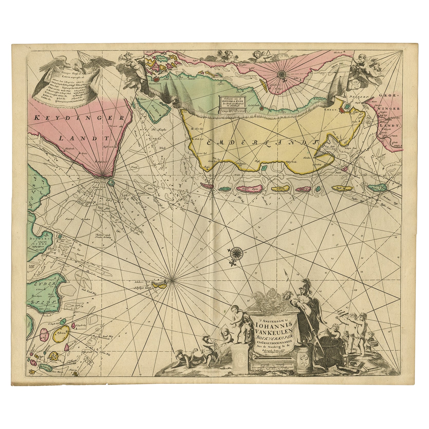
Rare Sea Chart of the East Frisian Islands or Watten and the North Sea, c.1700
Located in Langweer, NL
Description: Antique map titled 'Paskaarte van de rievier de Elve streckende van Oldenbroek tot Hamburgh.'
Rare and interesting chart of the East Frisian Islands (or Watten) and ...
Category
Antique Early 1700s Maps
Materials
Paper
$1,773 Sale Price
20% Off
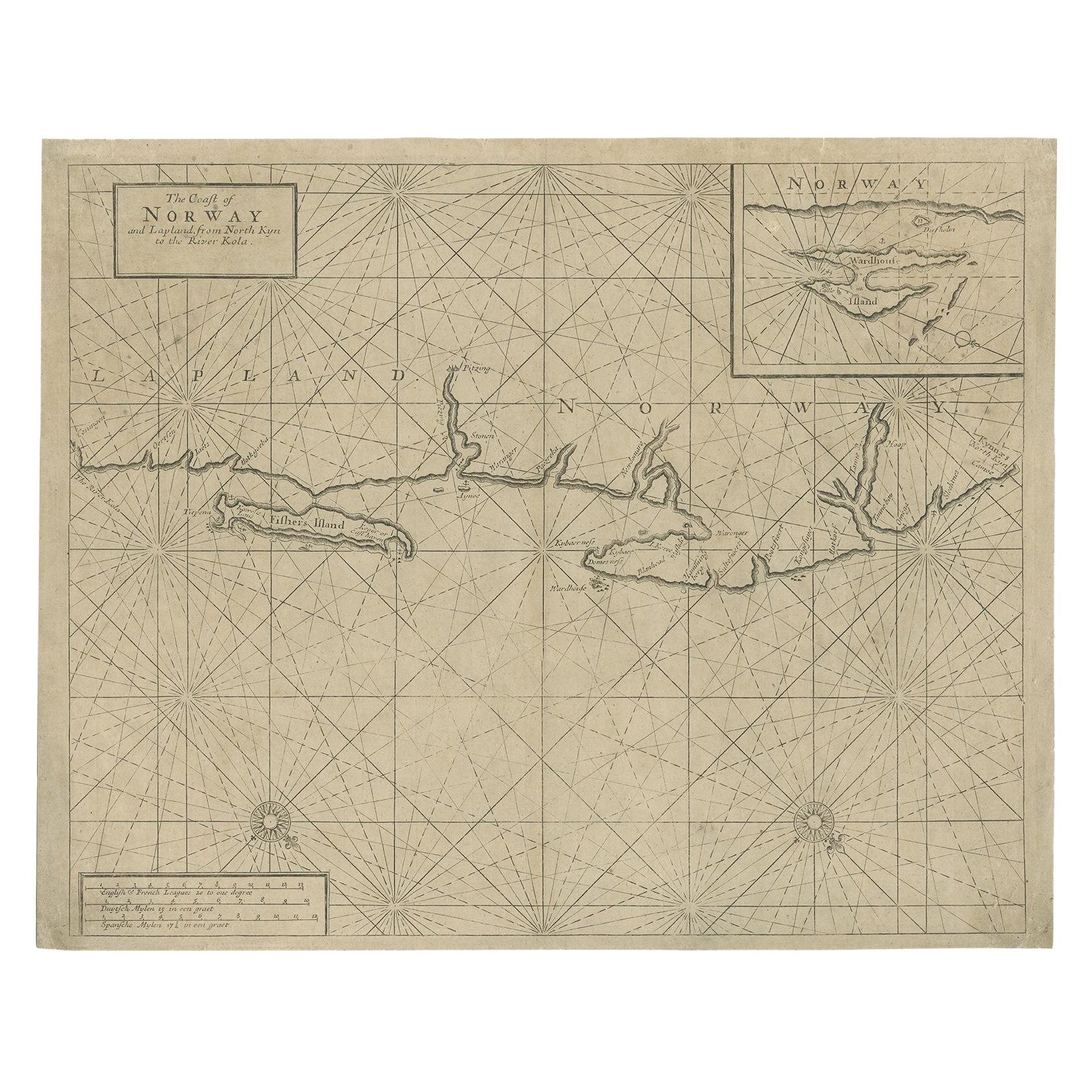
Old Sea Chart of Northern Norway, also depicting Part of Lapland & Russia, 1702
Located in Langweer, NL
Antique map titled 'The Coast of Norway and Lapland, from North kyn to the River Kola'.
Sea Chart of Northern Norway, also depicting part of Lapland and Russia. The map covers from the Kola river to what the map calls Fishers Island...
Category
Antique Early 1700s Maps
Materials
Paper
$469 Sale Price
20% Off
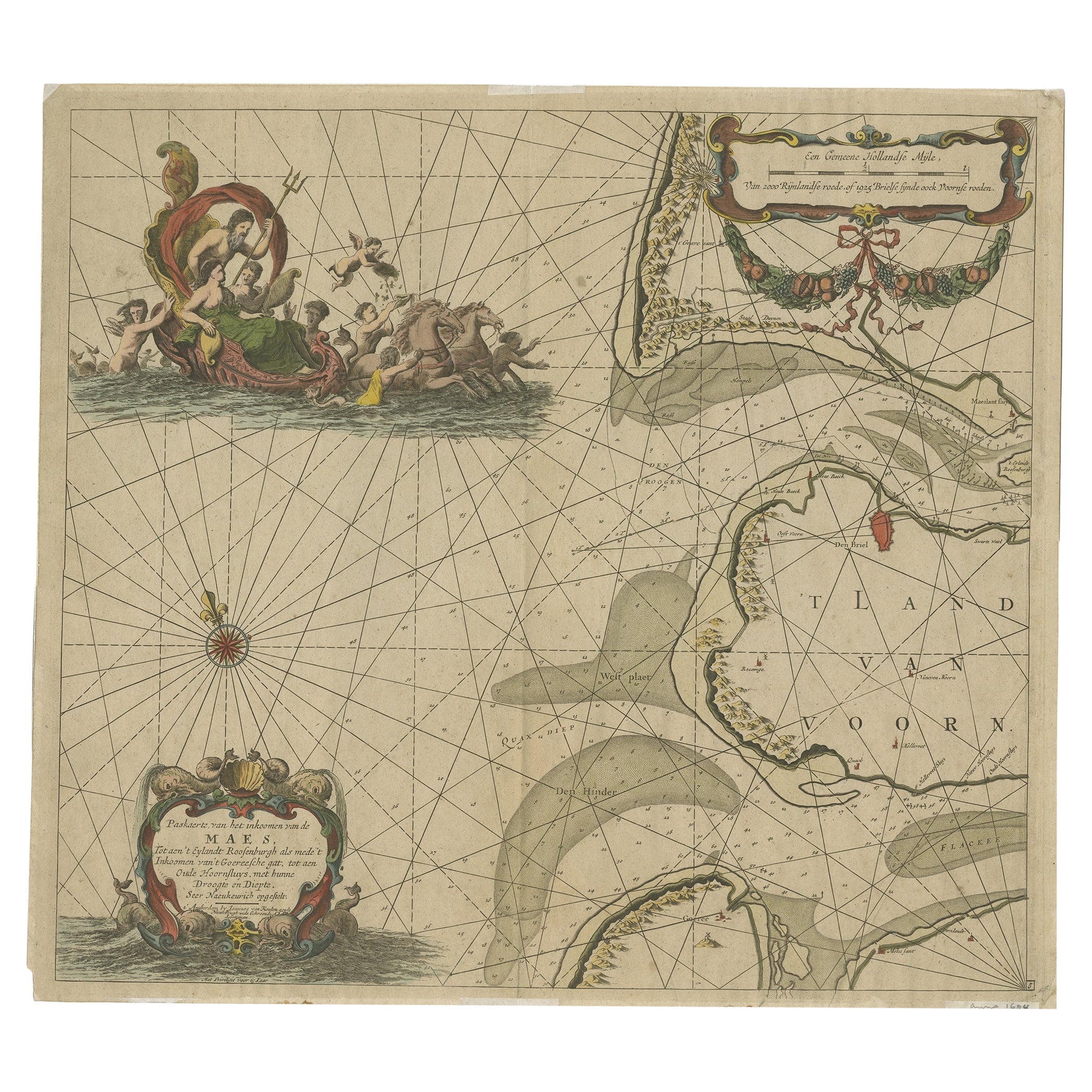
Original Antique Sea Chart of the Maas 'or Meuse' River with Neptunes, 1684
Located in Langweer, NL
Antique map titled 'Paskaerte van het inkoomen van de Maes (..)'.
Original antique sea chart of the Maas (or Meuse) river and part of the Dutch c...
Category
Antique 1680s Maps
Materials
Paper

$718 Sale Price
20% Off
Antique Sea Chart of North America by Ottens, circa 1745
Located in Langweer, NL
Antique map titled 'Septemtrionaliora Americae a Groenlandia (..)'. Sea chart of the northern waters of North America, including the coast of Labrador and pa...
Category
Antique Mid-18th Century Maps
Materials
Paper

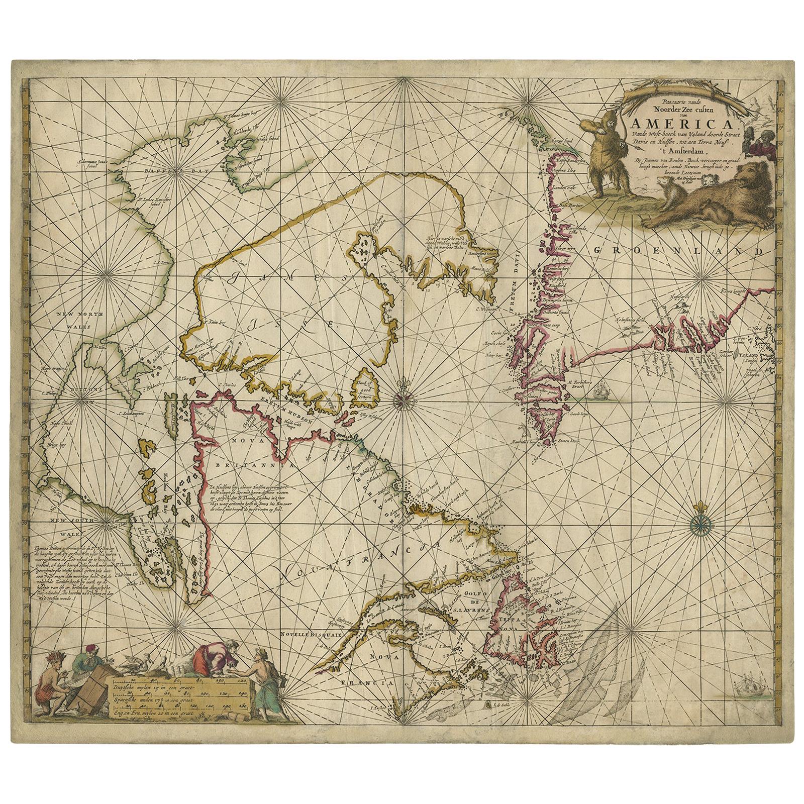
Antique Sea Chart of Hudson Bay and Arctic Canada by Van Keulen, circa 1681
Located in Langweer, NL
Antique map titled 'Pascaarte vande Noorderzee Custen van America (..)'. Sea chart of Hudson Bay and Arctic Canada. Compass roses, loxodromic lines, and ships decorate the oceans and...
Category
Antique Late 17th Century Maps
Materials
Paper
You May Also Like
17th Century Map of Denmark by French Cartographer Sanson, Dated 1658
By Nicolas Sanson
Located in Copenhagen, K
17th century map of Denmark by French cartographer Sanson.
Nicolas Sanson (20 December 1600-7 July 1667) was a French cartographer, termed by some the creator of French geography an...
Category
Antique 17th Century French Maps
Materials
Paper

Ancient Map-Poli Arctici (Map of the Poles)-Etching by Johannes Janssonius-1650s
By Johannes Janssonius
Located in Roma, IT
Poli Arctici is an ancient map realized in 1650 by Johannes Janssonius (1588-1664).
The Map is a Hand-colored etching, with coeval watercoloring.
Good conditions with slight foxing...
Category
1650s Modern Figurative Prints
Materials
Etching

Rugen Island, Germany: An Early 17th Century Map by Mercator and Hondius
By Gerard Mercator
Located in Alamo, CA
This is an early 17th century map entitled "Nova Famigerabilis Insulae Ac Ducatus Rugiae Desciptio" (Map of Rugen Island, Germany) by Gerard Mercator and Henricus and Joducus Hondiu...
Category
Early 17th Century Old Masters Landscape Prints
Materials
Engraving

Flanders, Holland & Norfolk: Hand-Colored 17th Century Sea Chart by Collins
By Captain Greenvile Collins
Located in Alamo, CA
This hand-colored chart of the seas about Flanders, Holland, Frisia, and Norfolk is from "Great Britain's Coasting Pilot. Being a New and Exact Survey of the Sea-Coast of England" by...
Category
Antique Late 17th Century English Maps
Materials
Paper

1646 Jansson Map Entitled "Procinvia Connactiae, " Ric.a006
Located in Norton, MA
1646 Jansson map entitled
"Procinvia connactiae,"
Ric.a006
Description: The PROVINCE of CONNAVGT 490 x 380From vol 4 of Jansson's Atlas Novus 1646, published in Amsterdam with...
Category
Antique 17th Century Unknown Maps
Materials
Paper

Hand-Colored 18th Century Homann Map of Denmark and Islands in the Baltic Sea
By Johann Baptist Homann
Located in Alamo, CA
An 18th century copper plate hand-colored map entitled "Insulae Danicae in Mari Balthico Sitae utpote Zeelandia, Fionia, Langelandia, Lalandia, Falstria, Fembria Mona" created by Joh...
Category
Antique Early 18th Century German Maps
Materials
Paper

More Ways To Browse
Map Case
Swedish 17th Century Furniture
Map Storage
17th Century Danish
Rack Print
Anglo Dutch
17th Century Dutch Door
Ornate Belt
Antique Map Case
Antique Map Storage
Dutch Golden Age Maritime Art
Antique Nautical Tools
Coffee Tables Europe
Marble Top Dining Tables
Nordiska Argentina
Pink And Black Rug
Black Wooden Chair
Orrefors Embassy