Items Similar to 1825 Buchon Map of Puerto Rico & Virgin Islands with Detailed Colonial History

Want more images or videos?
Request additional images or videos from the seller
1 of 6
1825 Buchon Map of Puerto Rico & Virgin Islands with Detailed Colonial History
$440.92
$551.1520% Off
£328.23
£410.2920% Off
€368
€46020% Off
CA$603.95
CA$754.9320% Off
A$671.72
A$839.6520% Off
CHF 350.75
CHF 438.4420% Off
MX$8,174.11
MX$10,217.6420% Off
NOK 4,479.63
NOK 5,599.5320% Off
SEK 4,201.10
SEK 5,251.3720% Off
DKK 2,801.46
DKK 3,501.8220% Off
Shipping
Retrieving quote...The 1stDibs Promise:
Authenticity Guarantee,
Money-Back Guarantee,
24-Hour Cancellation
About the Item
This map of Puerto Rico and the Virgin Islands, published by Jean Alexandre Buchon in 1825, offers a unique look at the Caribbean during a time of European colonial dominance.
Buchon’s work was part of the French edition of Carey & Lea's *American Atlas*, which was highly regarded for its comprehensive descriptions alongside detailed maps.
### Key Features:
1. European Colonization: The islands are color-coded to reflect European control at the time. Puerto Rico (in yellow) is marked as Spanish, the eastern Virgin Islands (in red) as British, and the western Virgin Islands (in green) as Danish. This color coding provides immediate insight into the colonial powers controlling these islands in the early 19th century.
2. Minimal Interior Detail: While the map itself does not delve deeply into the interior geography of the islands, it highlights key ports, towns, and bays, particularly along the coasts. This reflects the maritime and trade focus of the European colonial powers, who primarily viewed these islands in terms of their strategic and economic value.
3. Extensive Descriptive Text* What truly sets this map apart is the surrounding letterpress text in French. The descriptions cover the geography, economy, political structure, and social history of Puerto Rico and the Virgin Islands. This extensive narrative offers readers a thorough understanding of the islands’ importance in the colonial era, with specific details on population, trade, and governance.
4. Mapmaker and Publisher: Jean Alexandre Buchon was a well-known French geographer and historian who adapted Carey & Lea’s work for a French audience. His inclusion of detailed statistics and historical context further enriched the maps, making them not just cartographic tools but valuable resources for scholars and officials alike.
### Condition:
The map is in excellent condition (A grade), featuring bright colors and clean margins, with a well-preserved impression on heavy paper. Its well-maintained state enhances its value for collectors and historians.
### Historical Significance:
This map captures the colonial realities of the Caribbean in the early 19th century, when European powers were still competing for dominance in the region. The map's focus on colonial territories reflects the geopolitical tensions of the time and offers a glimpse into how the Caribbean islands were perceived and governed by foreign powers. The detailed accompanying text provides even more depth, making this map a unique resource for understanding the history of Puerto Rico and the Virgin Islands during this period.
- Dimensions:Height: 21.07 in (53.5 cm)Width: 31.11 in (79 cm)Depth: 0 in (0.02 mm)
- Materials and Techniques:Paper,Engraved
- Period:
- Date of Manufacture:1825
- Condition:Condition: good, given age. Vertical folding line as issued. General age-related toning and/or occasional minor defects from handling. Please study scans carefully.
- Seller Location:Langweer, NL
- Reference Number:Seller: BG-13619-21stDibs: LU3054341730612
About the Seller
5.0
Recognized Seller
These prestigious sellers are industry leaders and represent the highest echelon for item quality and design.
Platinum Seller
Premium sellers with a 4.7+ rating and 24-hour response times
Established in 2009
1stDibs seller since 2017
2,510 sales on 1stDibs
Typical response time: <1 hour
- ShippingRetrieving quote...Shipping from: Langweer, Netherlands
- Return Policy
Authenticity Guarantee
In the unlikely event there’s an issue with an item’s authenticity, contact us within 1 year for a full refund. DetailsMoney-Back Guarantee
If your item is not as described, is damaged in transit, or does not arrive, contact us within 7 days for a full refund. Details24-Hour Cancellation
You have a 24-hour grace period in which to reconsider your purchase, with no questions asked.Vetted Professional Sellers
Our world-class sellers must adhere to strict standards for service and quality, maintaining the integrity of our listings.Price-Match Guarantee
If you find that a seller listed the same item for a lower price elsewhere, we’ll match it.Trusted Global Delivery
Our best-in-class carrier network provides specialized shipping options worldwide, including custom delivery.More From This Seller
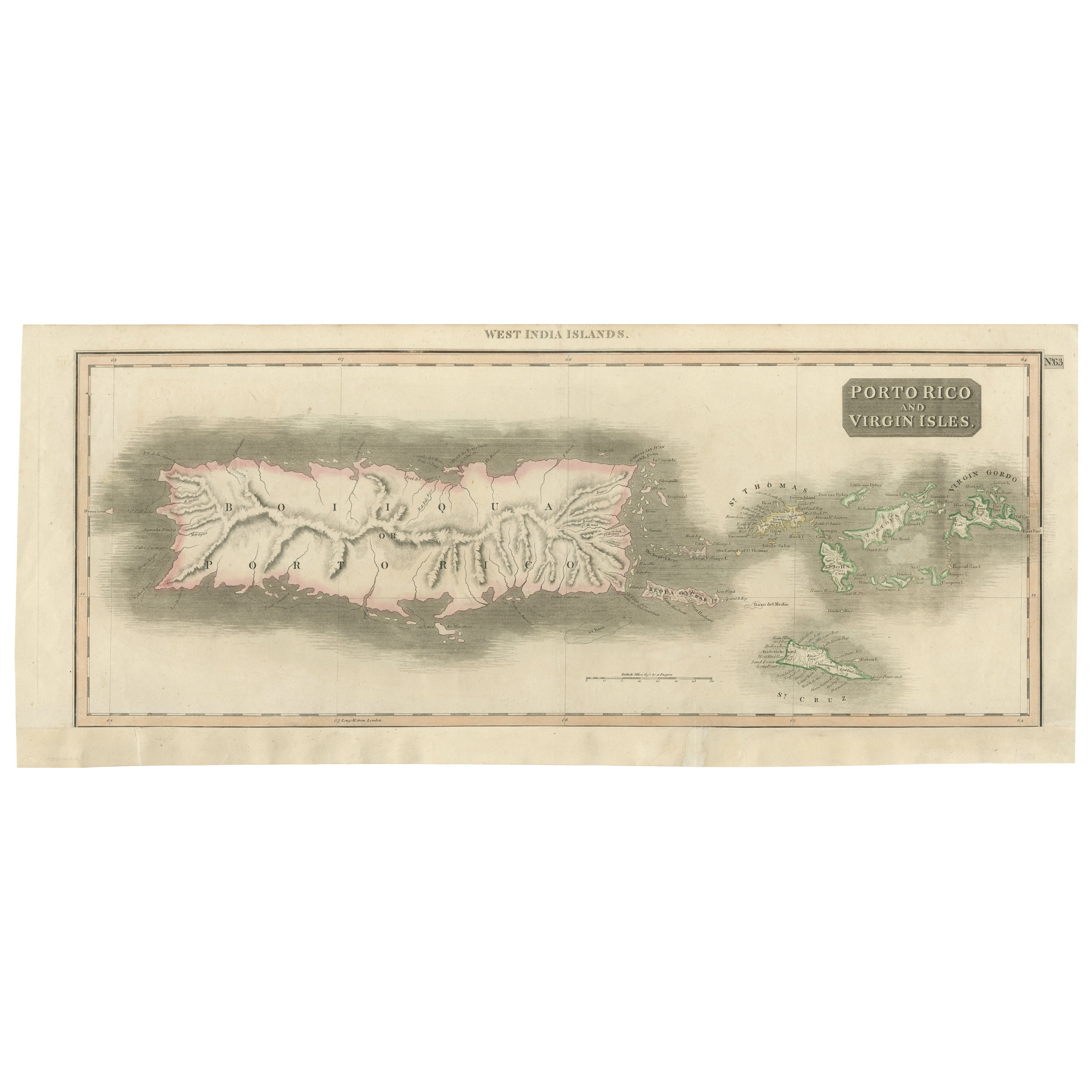
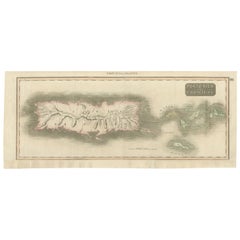
View All1817 Map of Puerto Rico and the Virgin Islands with Original Hand Coloring
Located in Langweer, NL
The title provided for this map is "Porto Rico and Virgin Isles," and it is an antique map from an early 19th century atlas, dated 1817, featuring original hand coloring. This histor...
Category
Antique Early 19th Century Maps
Materials
Paper
$354 Sale Price
20% Off
Free Shipping
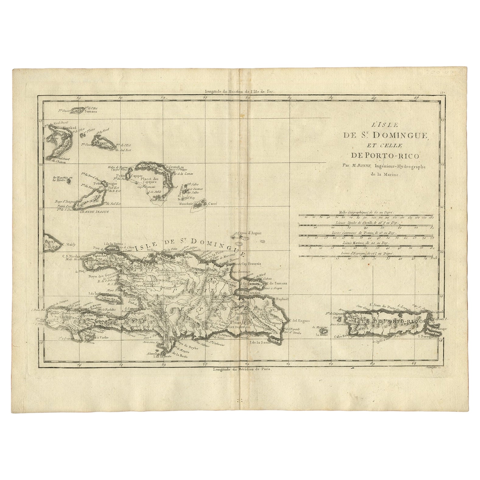
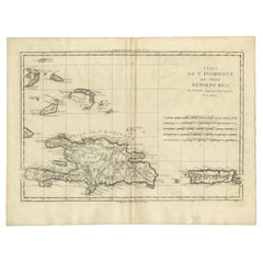
Detailed Antique Map of Santa Domingo, Puerto Rico, Eastern Bahamas, ca. 1780
Located in Langweer, NL
Description: Antique map titled 'L'Isle De St. Domingue, et celle De Porto-Rico.'
Detailed map of Santa Domingo, Puerto Rico, etc. Includes substanti...
Category
Antique 1780s Maps
Materials
Paper
$670 Sale Price
20% Off
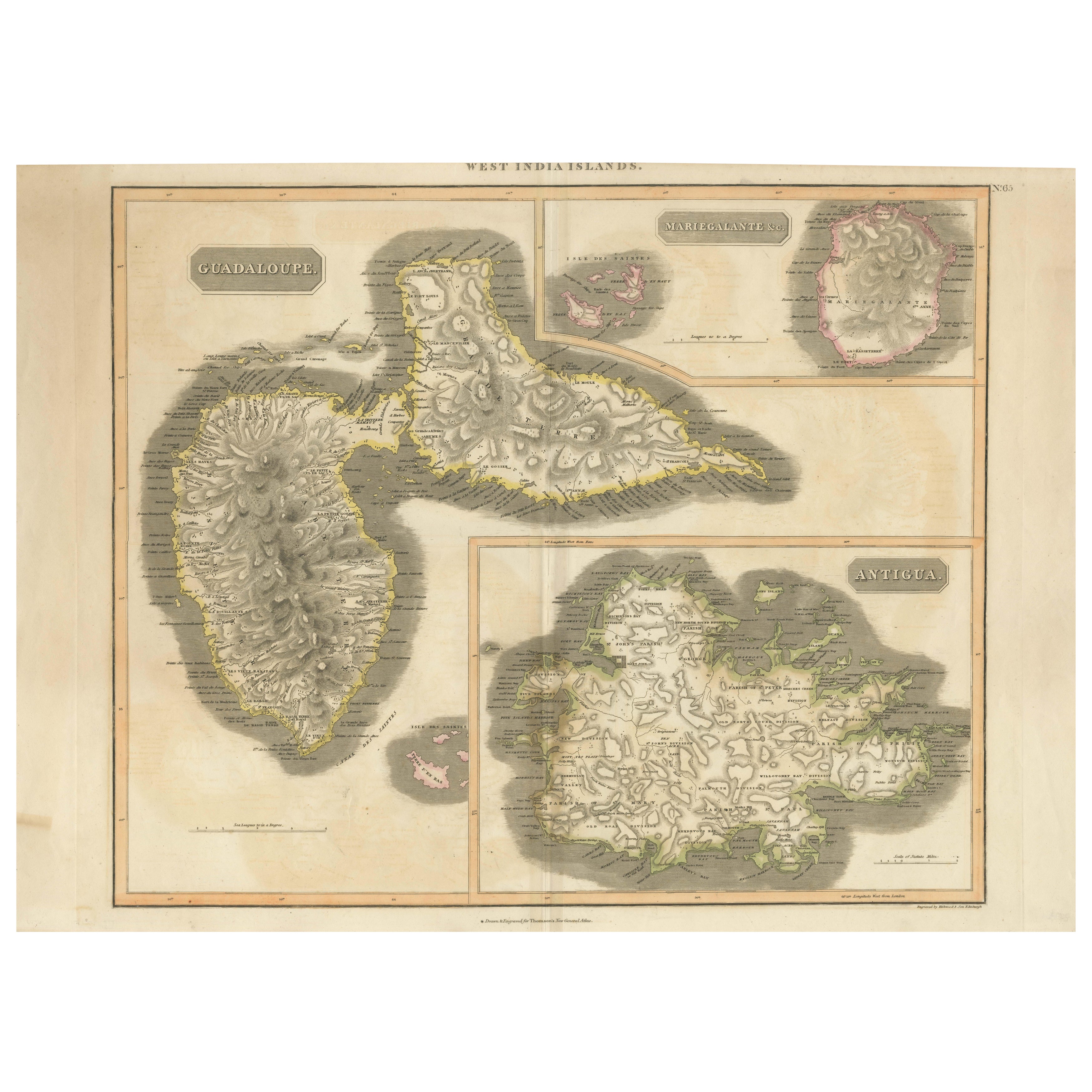
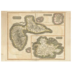
1821 Thomson Map of Guadeloupe, Marie-Galante and Antigua in the West Indies
Located in Langweer, NL
This map, published in 1821 by John Thomson, showcases Guadeloupe, Marie-Galante, and Antigua from the *West India Islands* collection. Part of Thomson's *New General Atlas*, it prov...
Category
Antique 1820s Maps
Materials
Paper
$555 Sale Price
20% Off
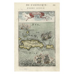
Antique 1683 Map of Hispaniola and Puerto Rico in the Caribbean by Mallet
Located in Langweer, NL
Title: 17th Century Map of Hispaniola and Puerto Rico by Mallet (1683)
This exquisite 17th-century map by Mallet, titled "I. d'Hispaniola et P.to Rico," showcases the islands of Hispaniola and Puerto Rico with remarkable detail. Published in Paris in 1683 as part of Mallet's monumental "Description de l'Univers," this map is a prime example of historical cartography from the era.
Map Features:
- Detailed depiction of Hispaniola and Puerto Rico
- Nearby islands: Inagua islands, Mayaguana, Île-à-Vache, Saona, and Mona
- Three illustrated naval battles surrounding the islands
- Hand-colored illustrations typical of the period
- Published in Paris, 1683, as part of the "Description de l'Univers"
- Engraved with artistic and geographic precision
Collectors and enthusiasts of antique maps will appreciate the historical significance and artistic detail of this rare print. Although small, the map is perfect for framing and this map serves as a captivating piece of history, reflecting the maritime exploration and territorial knowledge of the late 17th century.
The maker of the map is Allain Manesson Mallet, a notable 17th-century cartographer, military engineer, and author. Born in Paris in 1630, Mallet served in the French army and worked as a military engineer under Louis XIV. He later became a professor of mathematics and military architecture.
Mallet is best known for his monumental work, "Description de l'Univers," published in Paris in 1683. This extensive publication is considered one of the greatest works of its kind in the 17th century, providing detailed descriptions and maps of various parts of the world. Mallet's maps are renowned for their artistic quality, intricate details, and the inclusion of illustrative elements such as ships, sea creatures, and topographical features.
Mallet's contributions to cartography and his work in "Description de l'Univers" have left a lasting impact on the field, making his maps highly valued by collectors and historians.
Keywords:
- 17th-century map
- Mallet map 1683
- Hispaniola map
- Puerto Rico map
- Antique Caribbean map...
Category
Antique 1830s Maps
Materials
Paper
$364 Sale Price
20% Off
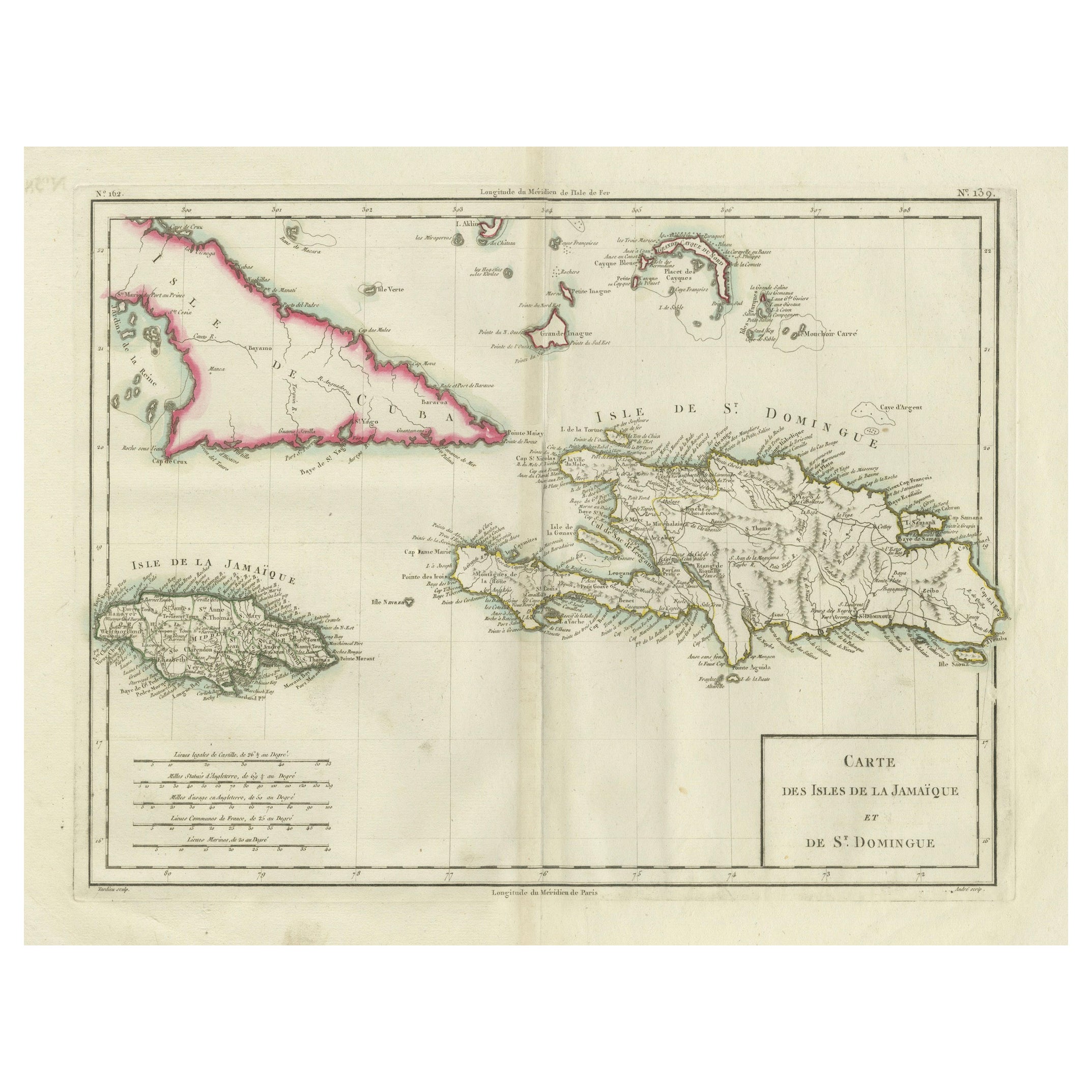
Antique Map of Jamaica and Hispaniola (Saint-Domingue and Santo Domingo), 1802
Located in Langweer, NL
This is an original antique map titled "Carte des Isles de la Jamaïque et de St. Domingue," depicting the islands of Jamaica and Saint-Domingue (modern-day Haiti and the Dominican Re...
Category
Antique Early 1800s Maps
Materials
Paper

$536 Sale Price
20% Off
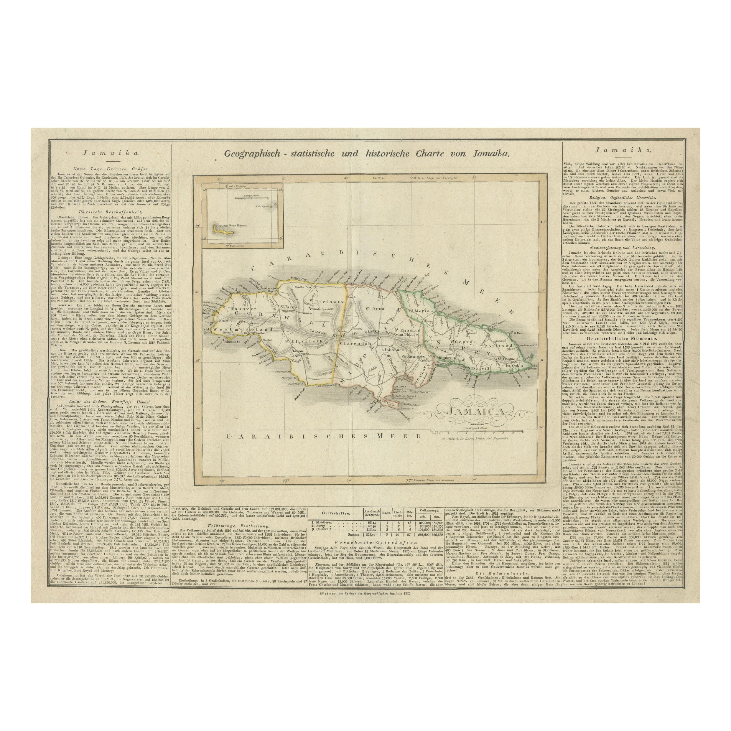
Detailed Antique Map of Jamaica - Published in Weimar, 1825
Located in Langweer, NL
This map of Jamaica is an interesting historical document.
This map is part of an atlas that was issued in six editions in English, French, and German ...
Category
Antique 1820s Maps
Materials
Paper
$517 Sale Price
20% Off
You May Also Like
St. Christophe 'St. Kitts' Island: An 18th Century Hand-colored Map by Bellin
By Jacques-Nicolas Bellin
Located in Alamo, CA
Jacques Bellin's copper-plate map of the Caribbean island of Saint Kitts entitled "Carte De De l'Isle St. Christophe Pour servir á l'Histoire Genle. des V...
Category
Antique Mid-18th Century French Maps
Materials
Paper

Map Colonies Francaises Martinique, 1845
Located in BUNGAY, SUFFOLK
Colonies Francaises, Martinique, Amerique DU SUD
Geographie et Statistique par V.Levasseur. Ing'r Geographe.
Illustre par Raymond Bonheur, peintre.
Grave par Laguihermie, Rue St...
Category
Antique 19th Century French Maps
Materials
Paper

Large Original Antique Map of The West Indies by Sidney Hall, 1847
Located in St Annes, Lancashire
Great map of The West Indies
Drawn and engraved by Sidney Hall
Steel engraving
Original colour outline
Published by A & C Black. 1847
Unframed
Free shipping.
Category
Antique 1840s Scottish Maps
Materials
Paper

Large Original Antique Map of The Canary Islands. 1894
Located in St Annes, Lancashire
Superb Antique map of The Canary Islands
Published Edward Stanford, Charing Cross, London 1894
Original colour
Good condition
Unframed.
Free shipping
Category
Antique 1890s English Maps
Materials
Paper

Puerto Rico 1910 Original Antique Map Of The Island In A Period Wood Frame
Located in Miami, FL
An antique framed map of Puerto Rico.
Very nice antique map of Puerto Rico printed in a folio of two pages. This map was printed in thin pa...
Category
Antique Early 1900s Puerto Rican American Classical Prints
Materials
Glass, Wood, Paper
$558 Sale Price
20% Off
Map Of Martinique - Etching - 19th Century
Located in Roma, IT
Map Of Martinique is an etching realized by an anonymous engraver of the 19th Century.
Printed within the series "France Pittoresque" at the top center.
The state of preservation o...
Category
19th Century Modern Figurative Prints
Materials
Etching

More Ways To Browse
French Colonial Furniture
Used Furniture Puerto Rico
Letterpress Furniture
Used Lea Furniture
Coffee Tables Europe
Marble Top Dining Tables
Nordiska Argentina
Pink And Black Rug
Black Wooden Chair
Orrefors Embassy
Black Ebonized
Elios Chair
Panache Designs
Plata Lappas
Red Retro Dining Set
Antique Bouquet
Antique Silver Glasses Case
Carlo Scarpa 1934 Chairs