Items Similar to 1859 Classic Map of France: Blackie's Imperial Geographic Masterpiece


Want more images or videos?
Request additional images or videos from the seller
1 of 10
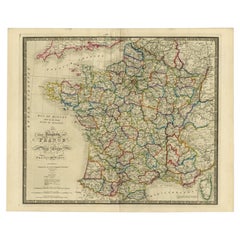
1859 Classic Map of France: Blackie's Imperial Geographic Masterpiece
$224.85
$299.7925% Off
£167.26
£223.0225% Off
€187.50
€25025% Off
CA$307.89
CA$410.5225% Off
A$342.33
A$456.4425% Off
CHF 178.75
CHF 238.3325% Off
MX$4,167.03
MX$5,556.0425% Off
NOK 2,280.74
NOK 3,040.9925% Off
SEK 2,136.94
SEK 2,849.2625% Off
DKK 1,427.33
DKK 1,903.1125% Off
Shipping
Retrieving quote...The 1stDibs Promise:
Authenticity Guarantee,
Money-Back Guarantee,
24-Hour Cancellation
About the Item
The "Antique Map of France" from 'The Imperial Atlas of Modern Geography', published in 1859 by W. G. Blackie, is a historically valuable cartographic work that offers a comprehensive depiction of France as it was understood in the mid-19th century.
**Key Features of the Map:**
1. **Geographical Coverage**: The map encompasses the entirety of France, illustrating the country's diverse landscapes, from the coastal regions of the Atlantic and the Mediterranean to the mountain ranges of the Alps and Pyrenees.
2. **Political Boundaries**: Reflecting the political divisions of the time, the map likely delineates the various departments of France, offering insight into the administrative organization of the country during the Second French Empire under Napoleon III.
3. **Urban and Rural Details**: Major cities like Paris, Marseille, Lyon, and Bordeaux are prominently marked, along with smaller towns and villages. The map provides a detailed view of France's urban landscape and rural settlements, highlighting key cultural and economic centers.
4. **Topographical Features**: The map would typically showcase France's topographical diversity, including river systems like the Seine, Loire, and Rhone, as well as significant geographical landmarks and natural features.
5. **Transportation Infrastructure**: Given the period, the map might detail the expanding network of railways and roads, reflecting the industrial growth and modernization of France during this era.
6. **Artistic and Aesthetic Elements**: True to the Victorian era's style, the map is likely to feature ornate borders, an elegant title script, and other artistic details, adding to its visual and historical appeal.
7. **Educational and Historical Significance**: As a part of 'The Imperial Atlas of Modern Geography', this map serves as an important educational tool, providing insights into the geographical understanding and perceptions of France in the mid-19th century.
This antique map of France is not only a collector’s item for enthusiasts of historical maps but also an invaluable resource for historians, geographers, and those interested in the historical development and geography of France. It captures a significant period in French history, making it a fascinating piece for anyone interested in the evolution of European geography and cartography.
- Dimensions:Height: 21.26 in (54 cm)Width: 14.57 in (37 cm)Depth: 0.02 in (0.5 mm)
- Materials and Techniques:
- Period:
- Date of Manufacture:1859
- Condition:Wear consistent with age and use. General age-related toning. some foxing, Please study image carefully.
- Seller Location:Langweer, NL
- Reference Number:Seller: BG-12685-1-101stDibs: LU3054325239232
About the Seller
5.0
Recognized Seller
These prestigious sellers are industry leaders and represent the highest echelon for item quality and design.
Platinum Seller
Premium sellers with a 4.7+ rating and 24-hour response times
Established in 2009
1stDibs seller since 2017
2,510 sales on 1stDibs
Typical response time: <1 hour
- ShippingRetrieving quote...Shipping from: Langweer, Netherlands
- Return Policy
Authenticity Guarantee
In the unlikely event there’s an issue with an item’s authenticity, contact us within 1 year for a full refund. DetailsMoney-Back Guarantee
If your item is not as described, is damaged in transit, or does not arrive, contact us within 7 days for a full refund. Details24-Hour Cancellation
You have a 24-hour grace period in which to reconsider your purchase, with no questions asked.Vetted Professional Sellers
Our world-class sellers must adhere to strict standards for service and quality, maintaining the integrity of our listings.Price-Match Guarantee
If you find that a seller listed the same item for a lower price elsewhere, we’ll match it.Trusted Global Delivery
Our best-in-class carrier network provides specialized shipping options worldwide, including custom delivery.More From This Seller
View AllAntique Map of France by A & C. Black, 1870
Located in Langweer, NL
Antique map titled 'France'. Original antique map of France with inset map of France as divided into provinces, before the revolution of 1789 and map of Corsica...
Category
Antique Late 19th Century Maps
Materials
Paper

$263 Sale Price
20% Off
Antique Map of France by Lapie, 1842
Located in Langweer, NL
Antique map titled 'Carte des Gaules'. Map of France. This map originates from 'Atlas universel de géographie ancienne et moderne (..)' by Pierre M. Lapie and Alexandre E. Lapie. Pie...
Category
Antique Mid-19th Century Maps
Materials
Paper

$479 Sale Price
20% Off
Antique Map of France by Lapie, 1842
Located in Langweer, NL
Antique map titled 'Carte de France'. Map of France. This map originates from 'Atlas universel de géographie ancienne et moderne (..)' by Pierre M. Lapie and Alexandre E. Lapie. Pier...
Category
Antique Mid-19th Century Maps
Materials
Paper

$527 Sale Price
20% Off
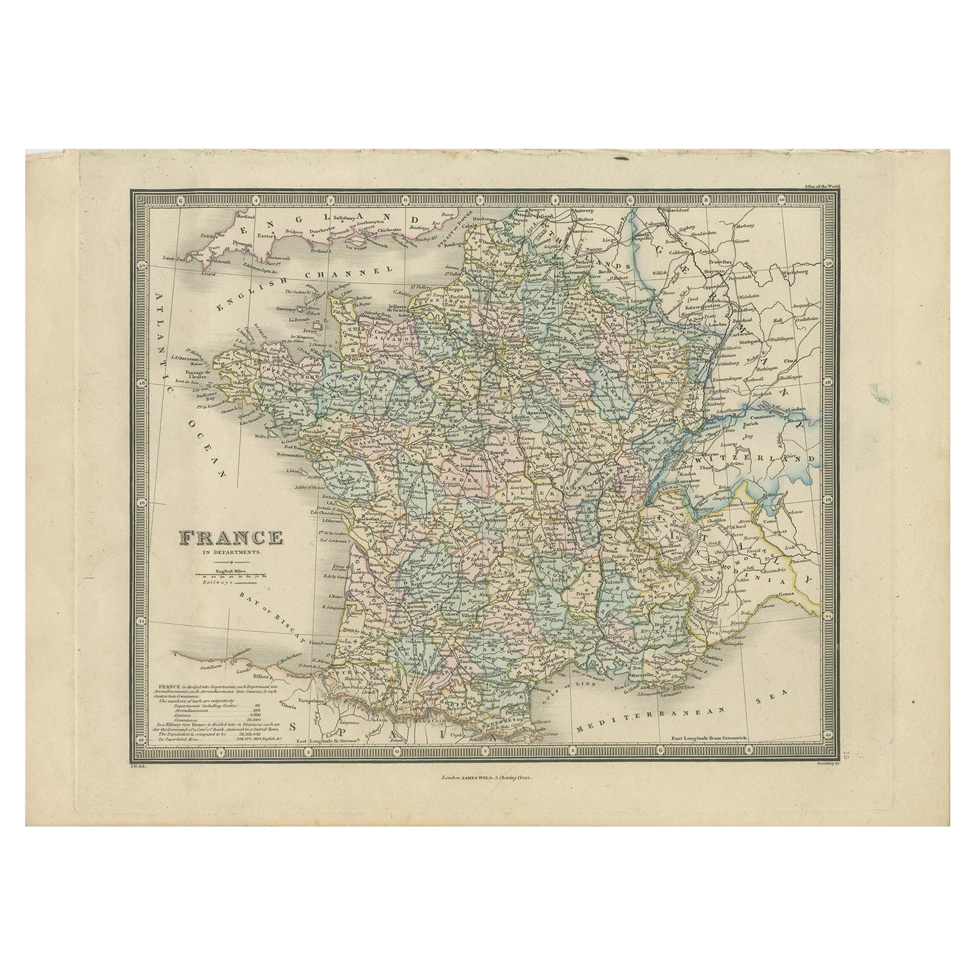
Antique Map of France in Departments by Wyld '1845'
Located in Langweer, NL
Antique map titled 'France in Departments'. Original antique map of France. This map originates from 'An Atlas of the World, Comprehending Separate Maps of its...
Category
Antique Mid-19th Century Maps
Materials
Paper

$191 Sale Price
20% Off
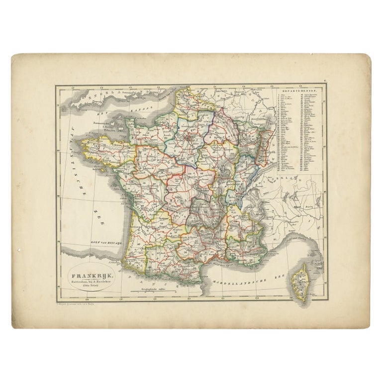
Antique Map of France from an Old Dutch School Atlas, 1852
Located in Langweer, NL
Antique map titled 'Frankrijk'. Map of France. This map originates from 'School-Atlas van alle deelen der Aarde' by Otto Petri. Artists and Engravers: Published by A. Baedeker (Otto ...
Category
Antique 19th Century Maps
Materials
Paper
$115 Sale Price
20% Off
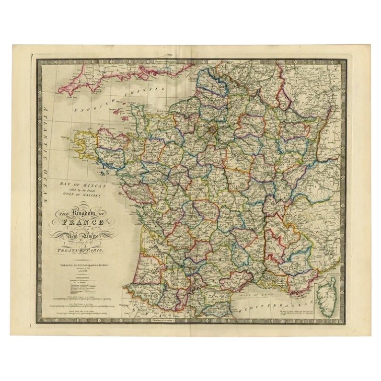
Antique Map of France according to the Treaty of Paris '1815', Published in 1854
Located in Langweer, NL
Antique map titled 'The Kingdom of France, describing the new limits according to the treaty of Paris. (1815)'. Large map of France. From James Wyld's 'A New General Atlas of Modern ...
Category
Antique 19th Century Maps
Materials
Paper
$646 Sale Price
30% Off
You May Also Like
Large 19th Century Map of France
Located in Pease pottage, West Sussex
Large 19th Century Map of France.
Remarkable condition, with a pleasing age worn patina.
Recently framed.
France Circa 1874.
Category
Antique Late 19th Century French Maps
Materials
Linen, Paper

France, Northern Part. Century Atlas antique map
Located in Melbourne, Victoria
'The Century Atlas. France, Northern Part.'
Original antique map, 1903.
Inset maps of 'France in Provinces' and 'Paris and Vicinity'.
Central fold as issued. Map name and number pr...
Category
Early 20th Century Victorian More Prints
Materials
Lithograph

Antique Map of France
Located in Dallas, TX
Nice antique map of France in wood frame. This would make a great gift for a collector. A wonderful accessory!
Category
Early 20th Century Decorative Art
Materials
Glass, Wood, Paper

$1,760
Map of France - Etching - 1820
Located in Roma, IT
Map of France is an Original Etching realized by an unknown artist of 19th century in 1820.
Very good condition on two sheets of white paper joined at t...
Category
1820s Modern Figurative Prints
Materials
Etching

Original Large Antique Map of Paris, France by John Dower, 1861
Located in St Annes, Lancashire
Fabulous monochrome map of Paris.
Vignettes of St Germain En Laye, Saint Cloud, Versailles and Fontainbleau.
Unframed.
Drawn by J.Dower.
Lithography by Weller. 4 sheets joined to...
Category
Antique 1860s English Victorian Maps
Materials
Paper

Large Vintage France Map, Continental, Historical Cartography, Late 20th Century
Located in Hele, Devon, GB
This is a large vintage map of France. A Continental, framed example of historical cartography, dating to the late 20th century, circa 1970.
Fas...
Category
Late 20th Century European Mid-Century Modern Prints
Materials
Glass, Wood, Paper

More Ways To Browse
Imperial Mid
Railway Map
Lyon Industrial
Napoleon Map
Map New Holland
Treasure Map
Caribbean Antiques
19th Century Map Of Africa
Antique Malaysia
Antique Map Of Ireland
Ships Log
Map Of Egypt
Nautical Maps
Antique Maps Of Long Island
James Cook Map
Antique Doctors Office Furniture
Pirate Furniture
Railroad Collectibles