Items Similar to 1890 "Map of Oregon, Kansas, California, and the Territories" by S. A. Mitchell

Want more images or videos?
Request additional images or videos from the seller
1 of 6
1890 "Map of Oregon, Kansas, California, and the Territories" by S. A. Mitchell
$950
£721.36
€824.93
CA$1,327.29
A$1,476.23
CHF 770.84
MX$17,964.19
NOK 9,844.85
SEK 9,232.73
DKK 6,156.74
Shipping
Retrieving quote...The 1stDibs Promise:
Authenticity Guarantee,
Money-Back Guarantee,
24-Hour Cancellation
About the Item
Presented is an 1890 map "Map of Oregon, Kansas, California, and the Territories" by S. A. Mitchell Jr. The map was issued in the atlas “Mitchell's New Intermediate Geography” published in Philadelphia.
The map is engraved, with attractive hand coloring by state. The states and territories colored and depicted are Washington, Oregon, California, Idaho, Nevada, Montana, Wyoming, Utah, Colorado, Arizona, New Mexico, North Dakota, South Dakota, Nebraska, Kansas, the Indian Territory, and “Public Land.” Depicted but not colored are the neighboring states of Minnesota, Iowa, Missouri, Arkansas, and Texas, Mexico and Lower California to the south, and the British Possessions to the north. Many cities and towns are depicted, as well as prominent rivers, mountains, lakes. Native American tribes are labelled throughout the map. Prominently featured are the many railroad routes, snaking through and crossing the western states, connecting the east to the west coast.
This map is a lovely snapshot of the western states and territories during a time of exponential population growth. The passage of the Homestead Act and completion of the first transcontinental railroad meant that, by 1870, the possibility of western migration was opened to more Americans than ever before. Mining, agriculture and especially large-scale ranching, and the development of towns and cities around railroad hubs attracted large numbers of settlers to the West. Nearly 400,000 settlers made the trek westward during the height of the 1870s. Between 1867 and 1879, Congress also authorized and funded four significant surveys, in effort to learn more about the area west of the Mississippi River.
North Dakota, South Dakota, Montana and Washington all gained statehood in November of 1889, with Idaho and Wyoming joining the Union in June and July of 1890. In 1890, the Superintendent of the Census described the western part of the country as having so many pockets of settled area that a frontier line could no longer be said to exist.
Samuel Augustus Mitchell Sr. (1792 - 1868) began his map-publishing career in the early 1830s. Having worked as a schoolteacher, Mitchell was frustrated with the low quality and inaccuracy of school texts of the period. His first maps were an attempt to rectify this problem. In the next 20 years Mitchell would become the most prominent American map publisher of the mid-19th century. Mitchell worked with prominent engravers J. H. Young, H. S. Tanner, and H. N. Burroughs before attaining the full copyright on his maps in 1847.
In 1849, Mitchell teamed up with printer Cowperthwait & Company to produce Mitchell's Universal Atlas and Mitchell's General Atlas. In the late 1850s most of the Mitchell copyrights were bought by Desilver and Co., who continued to publish his maps, many with modified borders and color schemes, until Mitchell's son, Samuel Augustus Mitchell Jr., entered the picture. S. A. Mitchell Jr. purchased most of the copyrights back from Desilver and, from 1860 on, published his own New General Atlas. The younger Mitchell became as prominent as his father and published atlases well into the late 19th century when most of the copyrights were again sold and the Mitchell firm closed its doors for the final time.
CONDITION:
Good condition. Engraved map, with original hand coloring. Color is vibrant. Paper is healthy, with moderate toning. Faint stains to the left upper image, all else clean.
Map is artfully framed with acid-free mats, UV Conservation clear glass, and a custom-built wooden frame. Framed Dimensions: 13 3/4" H x 15 3/4" W x 3/4" D
Accompanied by our company's letter of authenticity.
- Creator:Samuel Augustus Mitchell 1 (Maker)
- Dimensions:Height: 13.75 in (34.93 cm)Width: 15.75 in (40.01 cm)Depth: 0.75 in (1.91 cm)
- Style:Victorian (Of the Period)
- Materials and Techniques:
- Place of Origin:
- Period:
- Date of Manufacture:1890
- Condition:Additions or alterations made to the original: Framed by Rio Grande Custom Framing in Colorado Springs, CO, in December of 2024. Wear consistent with age and use. Minor fading.
- Seller Location:Colorado Springs, CO
- Reference Number:Seller: M3741stDibs: LU909742864342
About the Seller
4.9
Platinum Seller
Premium sellers with a 4.7+ rating and 24-hour response times
Established in 2010
1stDibs seller since 2011
461 sales on 1stDibs
- ShippingRetrieving quote...Shipping from: Colorado Springs, CO
- Return Policy
Authenticity Guarantee
In the unlikely event there’s an issue with an item’s authenticity, contact us within 1 year for a full refund. DetailsMoney-Back Guarantee
If your item is not as described, is damaged in transit, or does not arrive, contact us within 7 days for a full refund. Details24-Hour Cancellation
You have a 24-hour grace period in which to reconsider your purchase, with no questions asked.Vetted Professional Sellers
Our world-class sellers must adhere to strict standards for service and quality, maintaining the integrity of our listings.Price-Match Guarantee
If you find that a seller listed the same item for a lower price elsewhere, we’ll match it.Trusted Global Delivery
Our best-in-class carrier network provides specialized shipping options worldwide, including custom delivery.More From This Seller
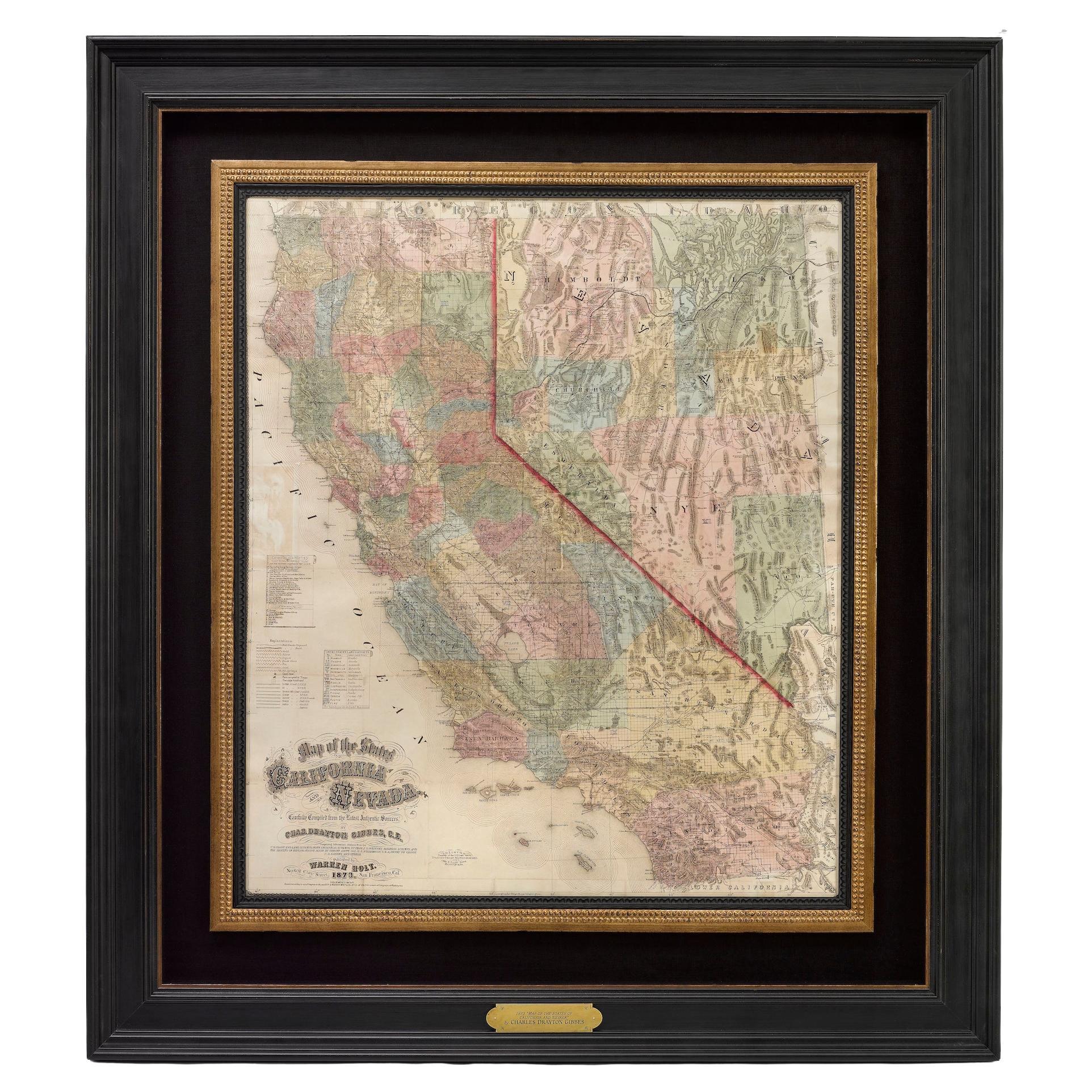
View All1873 "Map of the States of California and Nevada" by Chas. Drayton Gibbes
Located in Colorado Springs, CO
Presented is Warren Holt and Charles Drayton Gibbes' 1873 “Map of California and Nevada.” This map is considered to be one of the finest large-scale ...
Category
Antique 1870s American Maps
Materials
Paper

1864 Map of North America, Antique Hand-Colored Map, by Adolphe Hippolyte Dufour
Located in Colorado Springs, CO
Offered is a map of North America entitled Amerique du Nord from 1864. This rare, separately published wall map was produced by Adolphe Hippolyte Dufour. This map includes vibrant an...
Category
Antique 1860s French Maps
Materials
Paper

1846 "North America" Map, Engraved by I. Dower
Located in Colorado Springs, CO
Presented is an original 1846 map of “North America.” The map was drawn and engraved by I. Dower and published in London by Orr & Company. The map depicts North America, to include G...
Category
Antique 1840s English Victorian Maps
Materials
Paper

1859 "Map of the United States of America..." by J. H. Colton
By J.H. Colton
Located in Colorado Springs, CO
Presented is an 1859 “Map of the United States of America, the British Provinces, Mexico, the West Indies and Central America with Part of...
Category
Antique 1850s American Maps
Materials
Paper

1904 "Nell's Topographical Map of the State of Colorado"
Located in Colorado Springs, CO
This highly detailed pocket map is a topographical map of the state of Colorado by Louis Nell from 1904. The map "has been compiled from all available...
Category
Antique Early 1900s American Maps
Materials
Leather, Paper

1866 Ensign & Bridgman's Rail Road Map of the United States
Located in Colorado Springs, CO
Presented is an 1866 issue of “Ensign & Bridgeman’s Rail Road Map of the United States, showing Depots & Stations.” First published in 1856, this is the third edition, following anot...
Category
Antique 1860s American Late Victorian Maps
Materials
Paper

You May Also Like
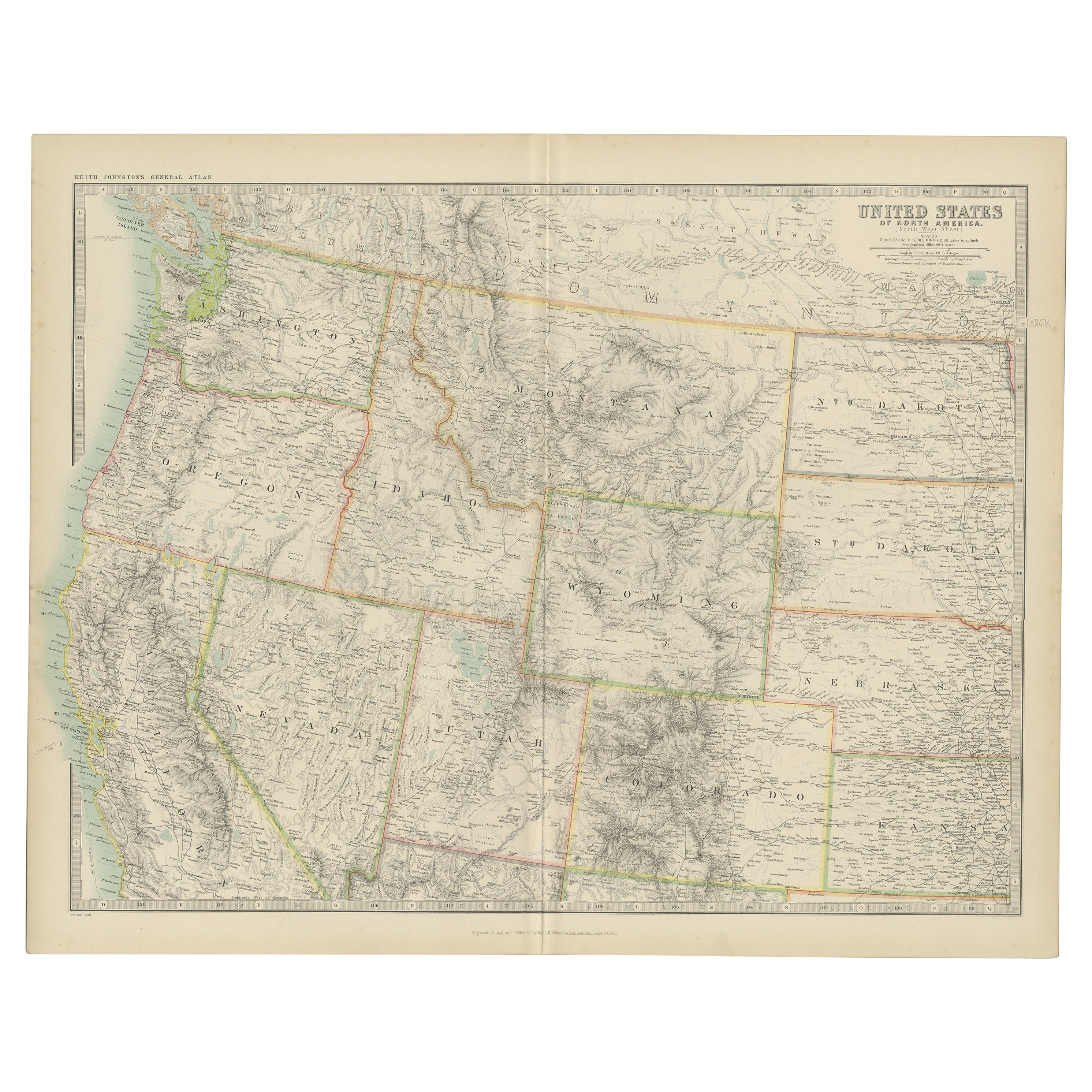
Antique Map of the United States 'North West' by Johnston, '1909'
Located in Langweer, NL
Antique map titled 'United States of North America'. Original antique map of the United States of North America ( North West ). This map originates from the ‘Royal Atlas of Modern Ge...
Category
Early 20th Century Maps
Materials
Paper

$239 Sale Price
20% Off
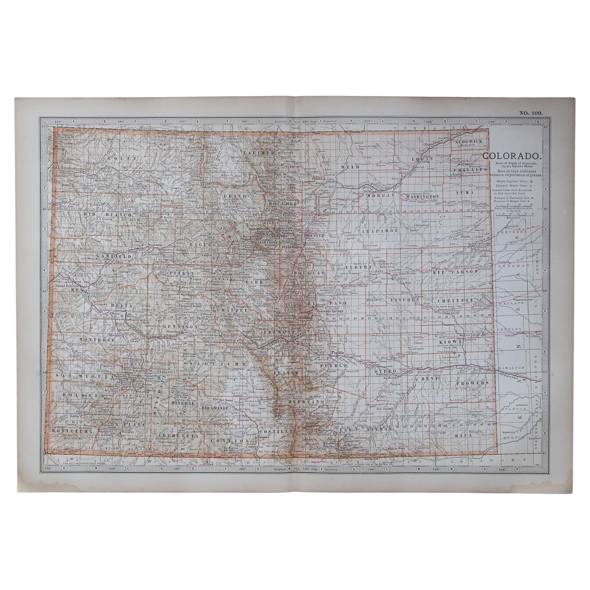
Original Antique Map of the American State of Colorado, 1903
Located in St Annes, Lancashire
Antique map of Colorado
Published By A & C Black. 1903
Original colour
Good condition
Unframed.
Free shipping
Category
Antique Early 1900s English Maps
Materials
Paper

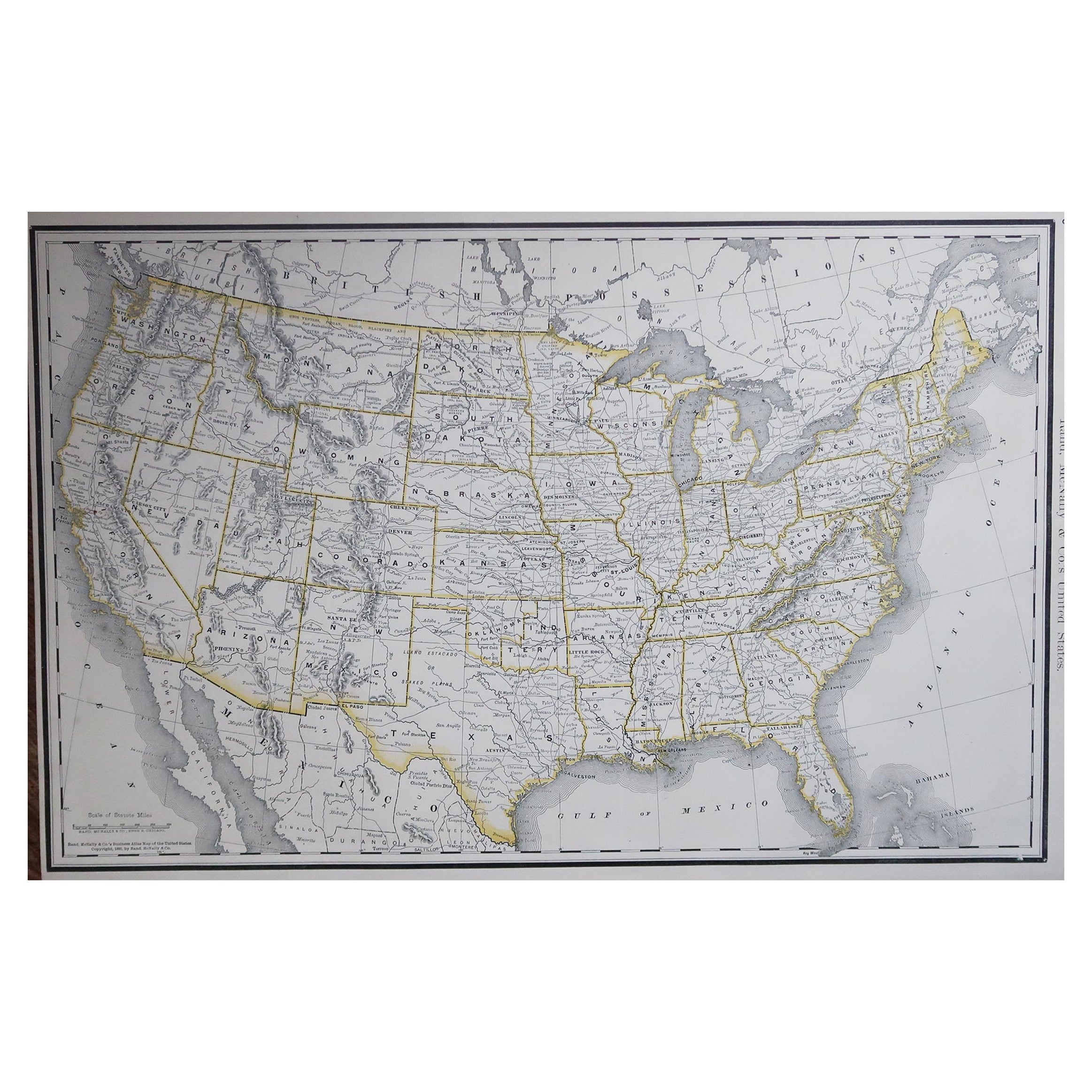
Large Original Antique Map of the United States of America. 1891
By Rand McNally & Co.
Located in St Annes, Lancashire
Fabulous map of The United States
Original color
By Rand, McNally & Co.
Dated 1891
Unframed
Free shipping.
Category
Antique 1890s American Maps
Materials
Paper

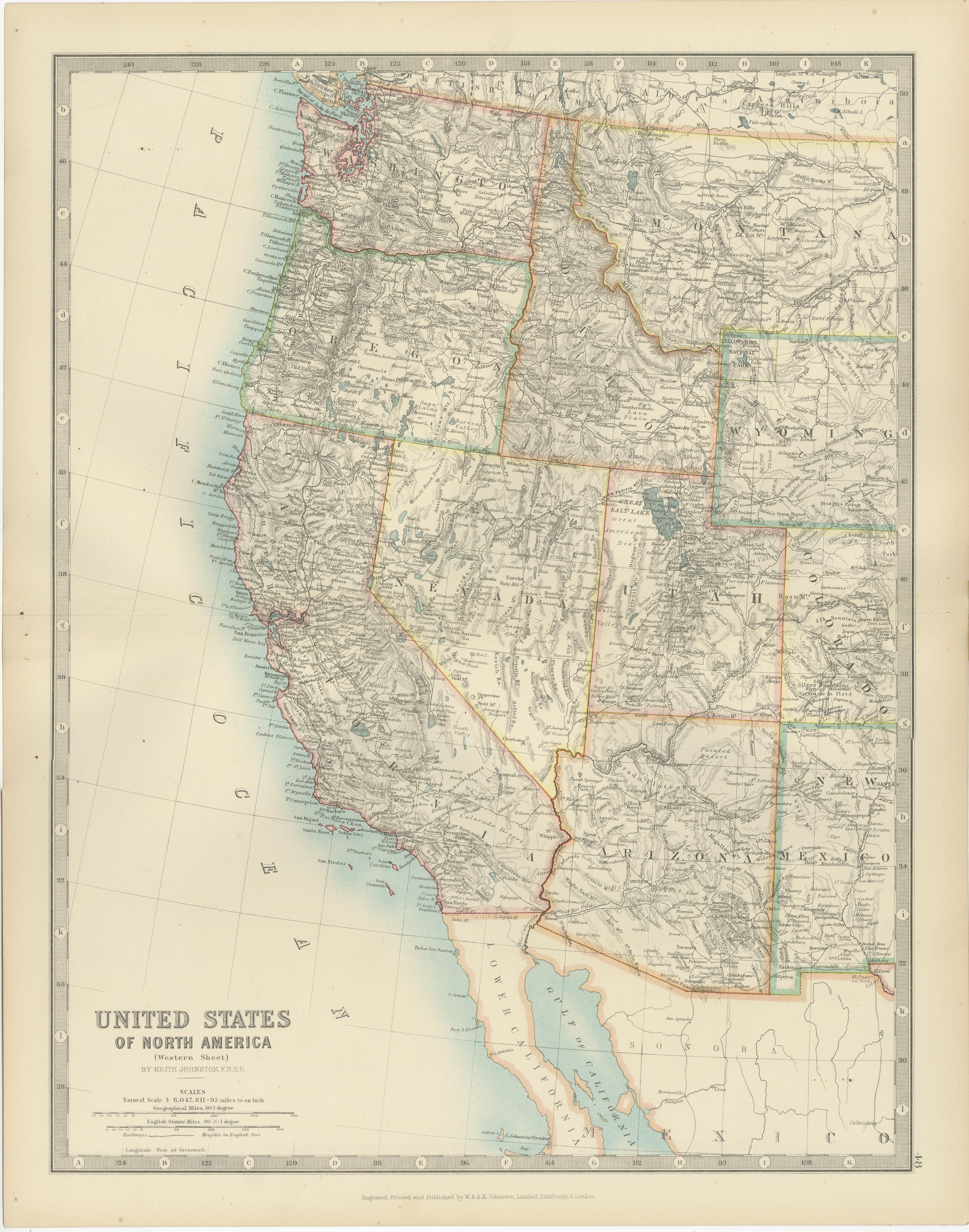
Map of Western United States 1903 – Railroads, State Borders, and Terrain
Located in Langweer, NL
Map of Western United States 1903 – Railroads, State Borders, and Terrain
This beautifully engraved map titled "United States of North America (Western Sheet)" was created by Keith ...
Category
Early 20th Century Maps
Materials
Paper

Antique Map of the United States by Titus '1871'
Located in Langweer, NL
Antique map titled 'The United States of America'. Original antique map of the United States. This map originates from 'Atlas of Prebl...
Category
Antique Late 19th Century Maps
Materials
Paper

$766 Sale Price
20% Off
Original Antique Map of the American State of California ( Southern Part ), 1903
Located in St Annes, Lancashire
Antique map of California ( Southern part )
Published By A & C Black. 1903
Original colour
Good condition
Unframed.
Free shipping
Category
Antique Early 1900s English Maps
Materials
Paper

More Ways To Browse
A Younger Furniture
Early California Furniture
Antique Furniture California
Furniture Kansas City
Mexican Stained Glass
19th Century Indian Door
Door Mat
Used Furniture In Arkansas
Letter Scales
Western Ranch Furniture
Antique Pocket Doors
Indian Door Frame
Montana Antiques
Victorian Stained Glass Door
Antique Mexican Door
Red Retro Dining Set
Antique Silver Glasses Case
Carlo Scarpa 1934 Chairs