
Samuel Augustus Mitchell Furniture

to
1
1
2
2
2
1
1
1
1
2
2
2
1
12,570
3,598
2,602
2,293
Creator: Samuel Augustus Mitchell
1847 Antique Map of Mexico, Texas and California by Samuel Augustus Mitchell

1847 Antique Map of Mexico, Texas and California by Samuel Augustus Mitchell

By Samuel Augustus Mitchell 1

Located in Colorado Springs, CO

Presented is the second edition of Samuel Augustus Mitchell's Map of Mexico, Including Yucatan & Upper California, an important map showing the progress of the Mexican-American War. ...

Category

1840s American Antique Samuel Augustus Mitchell Furniture

Materials

Paper

Mitchell's Fold-Out Map of the American Republic with Route-Book, Mid-19th C.

Mitchell's Fold-Out Map of the American Republic with Route-Book, Mid-19th C.

By Samuel Augustus Mitchell 1

Located in BARCELONA, ES

Rare mid-19th century American travel and cartographic publication by geographer and publisher Samuel Augustus Mitchell (1792–1868), accompanied by a large hand-colored fold-out map ...

Category

Mid-19th Century American Craftsman Antique Samuel Augustus Mitchell Furniture

Materials

Leather, Paper

Related Items
Antique Map of the City of London by Balbi '1847'

Antique Map of the City of London by Balbi '1847'

$188Sale Price|20% Off

H 9.06 in W 11.23 in D 0.02 in

Antique Map of the City of London by Balbi '1847'

Located in Langweer, NL

Antique map titled 'London'. Original antique map of the city of London. This map originates from 'Abrégé de Géographie (..)' by Adrien Balbi. Published 1847.

Category

Mid-19th Century Antique Samuel Augustus Mitchell Furniture

Materials

Paper

19th C. Pair of Watercolors, American School

19th C. Pair of Watercolors, American School

$3,250 / set

H 15 in W 12.5 in D 1 in

19th C. Pair of Watercolors, American School

Located in Kittery Point, ME

Western Wild Birds, each monogrammed ES lower left. Watercolor on Paper.  

Category

19th Century American Antique Samuel Augustus Mitchell Furniture

Materials

Paper

Mid 19th Century Coat Of Arms

Mid 19th Century Coat Of Arms

$4,950

H 39.5 in W 29.5 in D 2.5 in

Mid 19th Century Coat Of Arms

Located in New York, NY

Hand-picked by buyers at Ann-Morris Inc.

Category

Mid-19th Century English Antique Samuel Augustus Mitchell Furniture

Materials

Cut Steel

Antique Map of the United States by Balbi '1847'

Antique Map of the United States by Balbi '1847'

$188Sale Price|20% Off

H 9.06 in W 11.23 in D 0.02 in

Antique Map of the United States by Balbi '1847'

Located in Langweer, NL

Antique map titled 'Etats-Unis'. Original antique map of the United States. This map originates from 'Abrégé de Géographie (..)' by Ad...

Category

Mid-19th Century Antique Samuel Augustus Mitchell Furniture

Materials

Paper

Antique Map of France by Balbi '1847'

Antique Map of France by Balbi '1847'

$118Sale Price|20% Off

H 9.06 in W 11.23 in D 0.02 in

Antique Map of France by Balbi '1847'

Located in Langweer, NL

Antique map titled 'France'. Original antique map of France. This map originates from 'Abrégé de Géographie (..)' by Adrien Balbi. Published 1847.

Category

Mid-19th Century Antique Samuel Augustus Mitchell Furniture

Materials

Paper

19th Century Embroidered Silk Panel Map Of The World

19th Century Embroidered Silk Panel Map Of The World

$4,500

H 25.75 in W 33.75 in D 1.5 in

19th Century Embroidered Silk Panel Map Of The World

Located in Forney, TX

A rare and visually striking framed antique European embroidered silk panel. Exquisitely hand-crafted in Continental Europe in the 19th ...

Category

19th Century European Victorian Antique Samuel Augustus Mitchell Furniture

Materials

Silk, Thread

Mexico, Antique Map, Central America and Gulf of Mexico, Blackie Atlas 1860

Mexico, Antique Map, Central America and Gulf of Mexico, Blackie Atlas 1860

Located in Langweer, NL

Mexico, Antique Map, Central America and Gulf of Mexico, Blackie Atlas 1860 Description: This original antique map titled Mexico presents a detailed mid-19th-century view of Mexico ...

Category

Mid-19th Century British Antique Samuel Augustus Mitchell Furniture

Materials

Paper

Antique, Hand Colored Map of Washington, D.C., 19th Century

Antique, Hand Colored Map of Washington, D.C., 19th Century

Located in Houston, TX

Antique map of Washington, D.C. carefully hand colored bringing warmth and charm to the engraving. This map features the city's distinguished layout as designed by urban planner Pie...

Category

19th Century American American Classical Antique Samuel Augustus Mitchell Furniture

Materials

Paint, Paper

Antique Map of the City of Kolkata by Balbi '1847'

Antique Map of the City of Kolkata by Balbi '1847'

$141Sale Price|20% Off

H 9.06 in W 11.23 in D 0.02 in

Antique Map of the City of Kolkata by Balbi '1847'

Located in Langweer, NL

Antique map titled 'Calcutta'. Original antique map of the city of Kolkata, India. This map originates from 'Abrégé de Géographie (..)' by Adrien Balbi. Published 1847.

Category

Mid-19th Century Antique Samuel Augustus Mitchell Furniture

Materials

Paper

Antique Map of the British Isles by Balbi '1847'

Antique Map of the British Isles by Balbi '1847'

$141Sale Price|20% Off

H 9.06 in W 11.23 in D 0.02 in

Antique Map of the British Isles by Balbi '1847'

Located in Langweer, NL

Antique map titled 'Iles Britanniques'. Original antique map of the British Isles. This map originates from 'Abrégé de Géographie (..)' by Adrien Balbi. ...

Category

Mid-19th Century Antique Samuel Augustus Mitchell Furniture

Materials

Paper

Antique Map of the Eastern United States with Inset Map of Texas

Antique Map of the Eastern United States with Inset Map of Texas

$509Sale Price|20% Off

H 14.65 in W 17.84 in D 0.02 in

Antique Map of the Eastern United States with Inset Map of Texas

Located in Langweer, NL

Antique map titled 'Verein-Staaten von Nord-America mit Ausnahme Florida's und der Westlichen Territorien'. This map extends as far west as Louisiana and only includes the northern p...

Category

Mid-19th Century Antique Samuel Augustus Mitchell Furniture

Materials

Paper

Antique Map of the City of Rio de Janeiro by Balbi '1847'

Antique Map of the City of Rio de Janeiro by Balbi '1847'

Located in Langweer, NL

Antique map titled 'Rio de Janeiro'. Original antique map of the city of Rio de Janeiro, Brazil. This map originates from 'Abrégé de Géographie (..)' by Adrien Balbi. Published 1847.

Category

Mid-19th Century Antique Samuel Augustus Mitchell Furniture

Materials

Paper

Previously Available Items
1890 "Map of Oregon, Kansas, California, and the Territories" by S. A. Mitchell

1890 "Map of Oregon, Kansas, California, and the Territories" by S. A. Mitchell

By Samuel Augustus Mitchell 1

Located in Colorado Springs, CO

Presented is an 1890 map "Map of Oregon, Kansas, California, and the Territories" by S. A. Mitchell Jr. The map was issued in the atlas “Mitchell's New Intermediate Geography” publis...

Category

1890s American Victorian Antique Samuel Augustus Mitchell Furniture

Materials

Paper

1858 "Mitchell's New National Map Exhibiting the United States" Hanging Wall Map

1858 "Mitchell's New National Map Exhibiting the United States" Hanging Wall Map

By Samuel Augustus Mitchell 1

Located in Colorado Springs, CO

Presented is a beautifully engraved, large hanging wall map of the United States, Mexico, and West Indies by Samuel Augustus Mitchell. The map depicts the entire nation from the Atlantic to the Pacific Ocean. It also included inset maps of the “World on Mercator's Projection” and the “World on Globular Projection,” an inset of the Hawaiian Islands, distance and population tables, and more. First published in 1856, “Mitchell’s New National Map” was one of the most commercially successful maps of its time, regularly amended to update the changing territorial and state borders of the West. This specific map was published in Philadelphia in 1858. The map presents a compelling picture of an evolving American West, capturing the fluidity of pre-Civil War territorial boundaries. Much changed in the few years surrounding the publication of this map as the 1850s were characterized by the drawing of territorial boundaries, the creation of new states, continued relocation campaigns against Native Americans, and the rise and fall of small-scale territorial rebellions. On this map we see New Mexico in its late 1850s form, with a lower strip labeled Arizona. The same year as the publication of this map, the New Mexico territorial legislature adopted a resolution in favor of the creation of the Arizona Territory...

Category

1850s American Antique Samuel Augustus Mitchell Furniture

Materials

Paper

1846 Antique Map of Texas, Oregon, California, and Regions Adjoining by Mitchell

1846 Antique Map of Texas, Oregon, California, and Regions Adjoining by Mitchell

By Samuel Augustus Mitchell 1

Located in Colorado Springs, CO

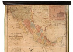
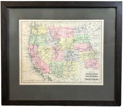
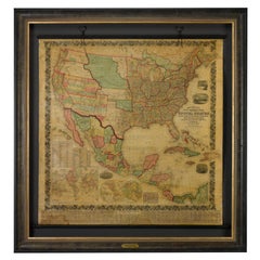
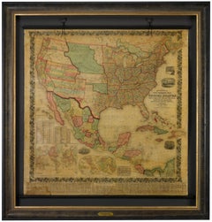
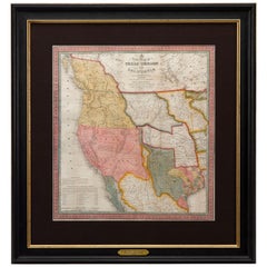
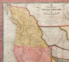
This is a finely colored example of the 1846 version of Mitchell's seminal map of Texas, Oregon Territory, California, and the Transmississippi West. Published in 1846 from Philadelphia, Mitchell's map of the West was one of the first large-format commercially published maps to show the Transmissisippi West, after the annexation of Texas in 1845. The map was perhaps the single most popular map of the period, used by gold seekers, immigrants, and others whose lives, fortunes, and attentions were focused Westward at the outset of the Mexican-American War. Beginning in 1846, the Transmississippi West was of particular interest to the American populace, as a result of two recent and related events. In 1845, Texas was admitted to the Union. This prompted Mexico to invade Texas in 1846, thus starting the U.S.-Mexican War. General curiosity about the new state as well as interest in the war led to Mitchell's timely map becoming quite popular. As stated in the "Accompaniment to Mitchell's new map of Texas, Oregon and California...," in which the map was sometimes issued, Mitchell used the latest and best cartographic sources for the map, including Arrowsmith's 1841 map of Texas, Fremont's and Emory's maps of their explorations in the region, compiled data from the Lewis & Clark expedition, Nicollet's map of the region between the Mississippi and the Missouri, and Wilkes map of Oregon...

Category

1840s American Antique Samuel Augustus Mitchell Furniture

Materials

Paper

1839 Map of the State of Ohio, Antique Tourist's Pocket Map by J.H. Young

1839 Map of the State of Ohio, Antique Tourist's Pocket Map by J.H. Young

By Samuel Augustus Mitchell 1

Located in Colorado Springs, CO

Presented is an early pocket map of Ohio, circa 1839. This map was produced by Samuel Augustus Mitchell as a reprint from the original of 1831; Mitchell's first pocket map of Ohio. This edition features various improvements to the first issue. The map is colored by counties and shows, roads, railroads, towns, and distances. Many other proposed railroads and canals are also shown. The map features some historical details, including the Harris Line surveyed in 1817 and Fulton's Line surveyed in 1814. In this edition, Toledo is present, which was founded in 1833 as part of Michigan and then re-founded in 1837 as part of Ohio following the conclusion of the "Toledo War." The map shows the northwest boundaries, claimed respectively by Michigan and Ohio. Labeled at bottom is both a "Profile of the Miami Canal" and a "Profile of the Ohio and Erie Canal...

Category

1830s American Antique Samuel Augustus Mitchell Furniture

Materials

Paper

Samuel Augustus Mitchell furniture for sale on 1stDibs.

Samuel Augustus Mitchell furniture are available for sale on 1stDibs. These distinctive items are frequently made of paper and are designed with extraordinary care. There are many options to choose from in our collection of Samuel Augustus Mitchell furniture, although beige editions of this piece are particularly popular. If you’re looking for additional options, many customers also consider furniture by Sioux Indian Art, Greg Noll, and Ernest Hemingway. Prices for Samuel Augustus Mitchell furniture can differ depending upon size, time period and other attributes — on 1stDibs, these items begin at $9,500 and can go as high as $9,500, while a piece like these, on average, fetch $9,500.