Items Similar to 1896 "Territory of Arizona" Map, Published by the General Land Office


Want more images or videos?
Request additional images or videos from the seller
1 of 9
1896 "Territory of Arizona" Map, Published by the General Land Office
$2,750
£2,073.51
€2,389.43
CA$3,814.99
A$4,274.68
CHF 2,225.13
MX$52,294.13
NOK 28,243.95
SEK 26,676.07
DKK 17,837.61
Shipping
Retrieving quote...The 1stDibs Promise:
Authenticity Guarantee,
Money-Back Guarantee,
24-Hour Cancellation
About the Item
Presented is an attractive "Territory of Arizona” map, from the “Report of the Governor of Arizona to the Secretary of the Interior." First published in 1894, this 1896 edition was revised and reconstructed by R. H. Morton and published by the General Land Office, based on “official Records of the General Land Office and other sources under the supervision of Harry King, C.E.” The report gave extensive detail regarding the territory’s population, including Native Americans of Arizona, the agriculture, mining, taxation, banks, transportation, immigration and tourism, as well as the current challenges to the territory’s development. This beautifully colored and highly detailed map was bound in the back of the 142 page Report. The map was lettered by M. Hendges and R.M. Towson.
The map is outlined by county in pink and detailed in black, with town names, roads, wagon roads, railroads, and mountains labeled. Intricate brown hachured mountain areas and the blue waterways combine to provide great visual impact. The map shows the extent of nine Indian reservations, outlined in green, and at least four military reservations, including Fort Apache, colored in solid red. The Grand Canyon is also shown and labeled as a Forest Reserve in pale pink. Any private land claims, confirmed and unconfirmed, are outlined in red, while townships not yet subdivided are identified with a circled cross.
Arizona, formerly part of the Territory of New Mexico, was organized as a separate territory on February 24, 1863. The United States acquired the region under the terms of the 1848 Treaty of Guadalupe Hidalgo and the 1853 Gadsden Purchase.
In the 1870s and 1880s, particularly after the arrival of the railroad in 1880, the population of the Arizona Territory expanded rapidly. With many Native American tribes relocated to reservations, white settlers drawn by the rich agricultural and mineral resources arrived in the region. Gold was discovered in 1863 near the first capital, Prescott. The 1877 discoveries of silver at Tombstone, near Tucson, and copper at Bisbee, also brought many settlers hoping to strike it rich. Many Mormon settlers moved south from Utah and Mexicans emigrated north. The flow of European emigrants also increased markedly thanks to the railroad. By the beginning of the 20th century, the population of the Arizona Territory exceeded 100,000. As the population grew, there was increasing sentiment for statehood, which was finally granted in 1912.
CONDITION:
Very good condition. Lithographed folding map, printed with original color. Map paper is lightly toned, color is strong and attractive. Fold lines, as issued. The map was removed from the original "Report of the Governor of Arizona to the Secretary of the Interior" booklet. Original booklet included. The booklet has red paper covers,142 pages with text and tables describing the territory including immigration, taxation, mining, banks, railroads, and much more. The booklet binding is tight and paper is clean, but the red paper covers have wear and lifting at the spine and a small chip at the right edge on the front cover.
Accompanied by our company's letter of authenticity.
- Dimensions:Height: 28.75 in (73.03 cm)Width: 25 in (63.5 cm)Depth: 1 in (2.54 cm)
- Materials and Techniques:
- Period:
- Date of Manufacture:1896
- Condition:Additions or alterations made to the original: Framed according to archival standards by Artem Art Services in Colorado Springs, CO. Wear consistent with age and use.
- Seller Location:Colorado Springs, CO
- Reference Number:Seller: M3921stDibs: LU909745349572
About the Seller
4.9
Platinum Seller
Premium sellers with a 4.7+ rating and 24-hour response times
Established in 2010
1stDibs seller since 2011
461 sales on 1stDibs
- ShippingRetrieving quote...Shipping from: Colorado Springs, CO
- Return Policy
Authenticity Guarantee
In the unlikely event there’s an issue with an item’s authenticity, contact us within 1 year for a full refund. DetailsMoney-Back Guarantee
If your item is not as described, is damaged in transit, or does not arrive, contact us within 7 days for a full refund. Details24-Hour Cancellation
You have a 24-hour grace period in which to reconsider your purchase, with no questions asked.Vetted Professional Sellers
Our world-class sellers must adhere to strict standards for service and quality, maintaining the integrity of our listings.Price-Match Guarantee
If you find that a seller listed the same item for a lower price elsewhere, we’ll match it.Trusted Global Delivery
Our best-in-class carrier network provides specialized shipping options worldwide, including custom delivery.More From This Seller
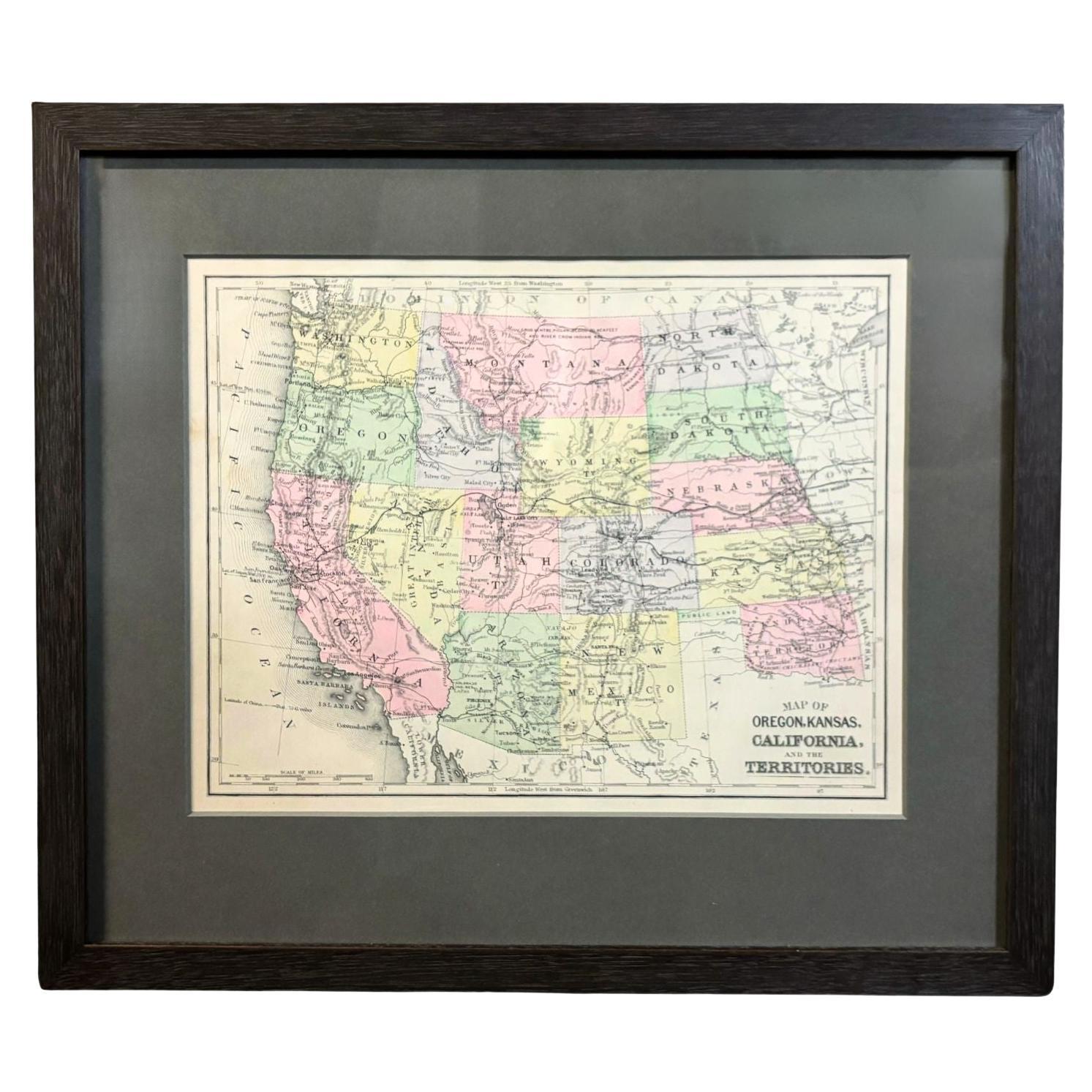
View All1890 "Map of Oregon, Kansas, California, and the Territories" by S. A. Mitchell
By Samuel Augustus Mitchell 1
Located in Colorado Springs, CO
Presented is an 1890 map "Map of Oregon, Kansas, California, and the Territories" by S. A. Mitchell Jr. The map was issued in the atlas “Mitchell's New Intermediate Geography” publis...
Category
Antique 1890s American Victorian Maps
Materials
Paper

1840 Map of the City of Washington Published by William M. Morrison
Located in Colorado Springs, CO
This map, printed in 1840, is a detailed representation of Washington, D.C. in the mid-19th century. The map shows block numbers, wards, and government buildings as well as details o...
Category
Antique 1840s American Federal Maps
Materials
Paper

1842 Wall Map of the United States by J. H. Young, Published by S. A. Mitchell
Located in Colorado Springs, CO
Presented is an 1842 hanging “Map of the United States,” engraved by J. H. Young and published by Samuel Augustus Mitchell, Philadelphia. This is a beautiful example of the rare 1842...
Category
Antique 1840s American Maps
Materials
Paper

"Taylor and His Generals, " First Edition, Published by E. H. Butler & Co., 1847
Located in Colorado Springs, CO
Taylor and his Generals. New York: E.H. Butler & Co., 1847. First Edition. Rebound in quarter leather and marble paper boards. Housed in custom slipcase.
Presented is the 1847 First Edition of Taylor and His Generals. Published by E.H. Butler & Company, the book has numerous portraits and engravings throughout. It has been beautifully rebound in quarter leather and marble paper boards. The spine has gilt embossed decoration stating that it’s a first edition. The book is housed in a custom-built archival slipcase with a photo of Taylor on the front.
Written and published before Taylor ran for the Presidency, this book would have been a powerful propaganda tool for the soon-to-be 12th President of the United States. The full title page describes the work as “Taylor and His Generals; A Biography of Major-General Zachary Taylor; And Sketches of the Lives of Generals Worth, Wool, and Twiggs with a full account of the Actions of their Various Divisions in Mexico Up to the Present Time; Together with a Sketch of the Major-General Winfield Scott and an Account of his Divisions in Mexico.”
Taylor fought and commanded troops in the War of 1812, Black Hawk War, and the Second of the Seminole Wars before playing a major role in the victory of the Mexican-American War. The book takes the reader through the early life of Taylor and his military career with a particular focus on his surprising victory at the Battle of Buena Vista. Generals Worth, Wool, and Twiggs that served under Taylor and Major-General Scott each get a chapter dedicated to their own history and military careers
The Battle of Buena Vista took place in February of 1847 during the Mexican-American War. With only about 5,000 soldiers, Taylor repelled General Antonio Lopez de Santa Anna...
Category
Antique 1840s American Books
Materials
Paper

1859 "Map of the United States of America..." by J. H. Colton
By J.H. Colton
Located in Colorado Springs, CO
Presented is an 1859 “Map of the United States of America, the British Provinces, Mexico, the West Indies and Central America with Part of...
Category
Antique 1850s American Maps
Materials
Paper

1847 Ornamental Map of the United States & Mexico by H. Phelps
Located in Colorado Springs, CO
Offered is an original 1847 ornamental map of the U.S. entitled "Ornamental Map of the United States & Mexico" by Humphrey Phelps. The map was issued as an act of Congress by Phelps on Fulton Street, New York. The broadside is elaborately hand-colored.
This is a very detailed and graphic propaganda map of the United States expressing U.S. dominance of the North American continent. The hand-colored map proclaims the Manifest Destiny, with the recent acquisition of Upper California and Texas at the conclusion of the Mexican-American War. The newly acquired land is boldly colored, standing in stark contrast to the rest of the U.S. The map details a potential route for a railroad running from New York City, to Buffalo, to Chicago, then west along the Oregon Trail to Oregon City. This route anticipates the construction of the transcontinental railroad by nearly 20 years.
The map includes elaborately detailed renderings of George Washington, Hernan Cortez, and Montezuma at top to represent European expansion to the Americas. At bottom are four inset designs with text showing the following: a chronological history of the U.S. beginning from settlement to the U.S. victory in the Mexican-American war; an illustration of General Zachary Taylor with details on the Oregon Territory; an illustration of the Aztec Temple of the Sun in Tenochtitlan and a chronology of the Conquest of the Aztec Empire under Cortez; a portrait of General Antonio Lopez de Santa Anna...
Category
Antique 1840s American Maps
Materials
Paper

You May Also Like
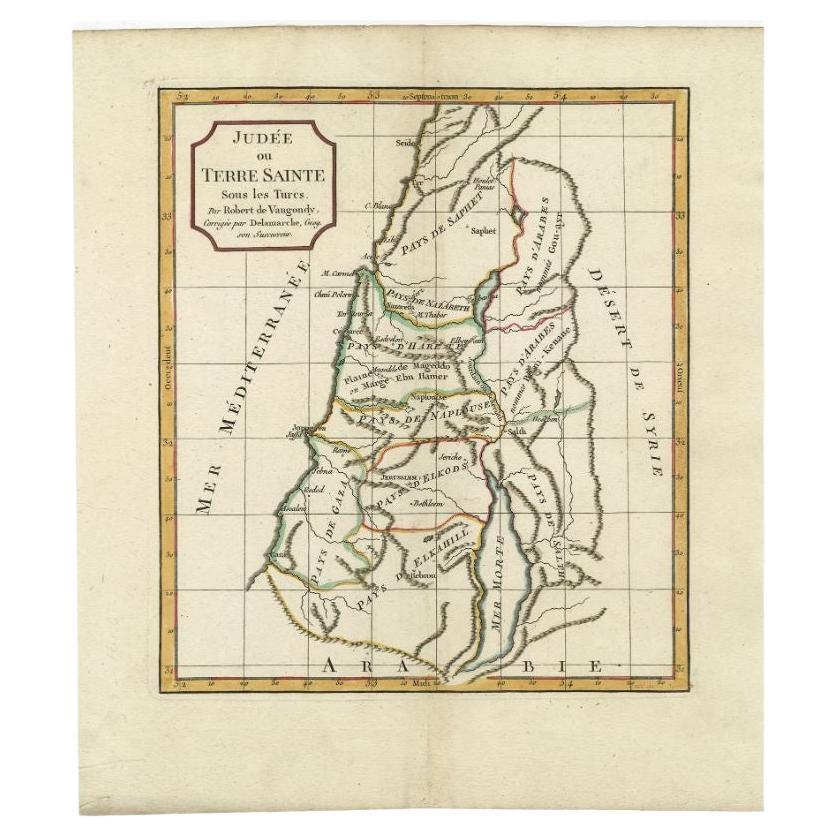
Antique Map of the Holy Land by Delamarche, 1806
By Charles Francois Delamarche
Located in Langweer, NL
Antique map titled 'Judee ou Terre Sainte sous les Turcs.' This map shows the holy land under the Turcs. By Robert de Vaugondy, revised and published by ...
Category
Antique 19th Century Maps
Materials
Paper
Antique Map of the Holy Land by Schut, 1710
Located in Langweer, NL
Antique map of the Holy Land titled 'Het Beloofde Landt Canaan.' Very detailed and decorative map of the Holy Land embellished with sailing ships and com...
Category
Antique 18th Century Maps
Materials
Paper

$402 Sale Price
20% Off
Antique Map of the Holy Land by Keur, 1748
Located in Langweer, NL
Antique Map Holy Land titled 'De Gelegentheyd van t'Paradys ende t'Landt Canaan, Mitsgaders d'eerst bewoonde Landen der Patriarchen'. Includes five decorative vignettes, including No...
Category
Antique 18th Century Maps
Materials
Paper

$333 Sale Price
20% Off
Antique Map of the Holy Land by Danckerts, c.1710
Located in Langweer, NL
Antique map titled 'Afbeeldinge van de Veertich-Iaarige Reyse der Kinderen Israëls uyt Egypten door de Roode Zee en de Woestyne tot in 't Beloofde Landt Canaan'. Map of the Holy Land...
Category
Antique 18th Century Maps
Materials
Paper

$341 Sale Price
20% Off
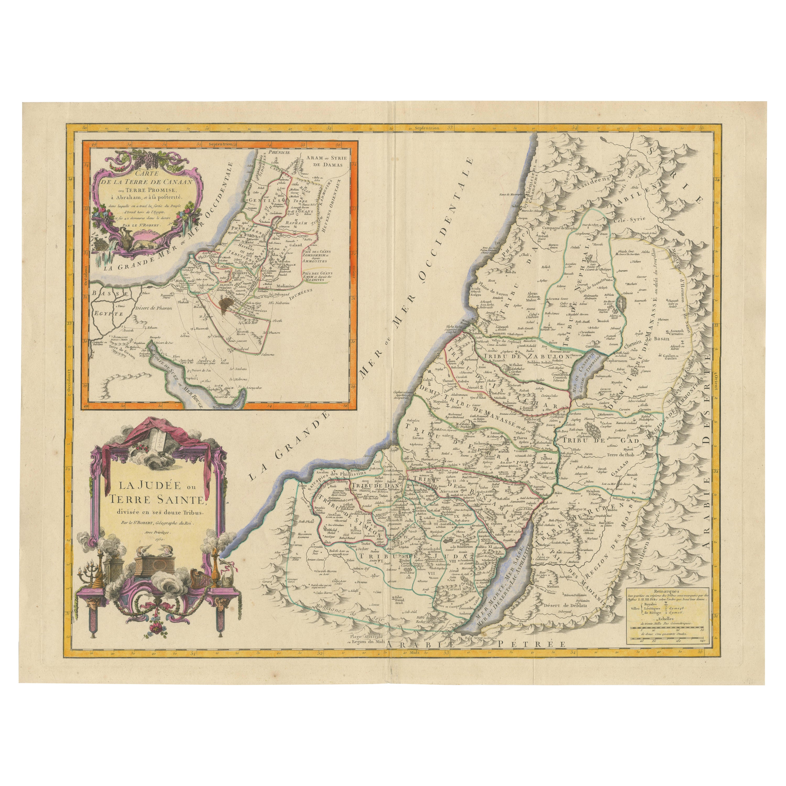
1750 Map of the Holy Land: The Land of Canaan and the Twelve Tribes
Located in Langweer, NL
Carte de la Terre de Canaan ou Terre Promise
Cartographer: Le St. Robert
Date of Publication: 1750
This exquisite 18th-century map, 'Carte de la Terre de Canaan ou Terre Promise', w...
Category
Antique 1750s Maps
Materials
Paper

Antique Map of the Holy Land, c.1717
Located in Langweer, NL
Antique map Israel titled 'Tabula Geographica Terrae Sanctae'. Rare edition made after a map of the Holy Land by J. Bonfrerius. The map is oriented ...
Category
Antique 18th Century Maps
Materials
Paper

$373 Sale Price
20% Off
More Ways To Browse
Antique Paper Company
Antique Governor
Foldable Military
Antique Flow Blue
Antique Wagon Wagon
Antique Bank Table
Indian Silver Table
Antique Mexican Table
Antique Tombstone
Used Furniture Tucson
Indian Folding Table
Railroad Table
Military Folding Table
Antique Mormon Furniture
6x10 Rug
Styles Of Antique Desks
Black And White Coffee Table
Metal Relief