Items Similar to 18th Century Antique Engraving of the Southern Hemisphere by G. de L'Isle


Want more images or videos?
Request additional images or videos from the seller
1 of 10
18th Century Antique Engraving of the Southern Hemisphere by G. de L'Isle
$938.73
$1,173.4120% Off
£702.66
£878.3320% Off
€796
€99520% Off
CA$1,291.96
CA$1,614.9520% Off
A$1,440.02
A$1,800.0320% Off
CHF 755.53
CHF 944.4120% Off
MX$17,585.03
MX$21,981.2820% Off
NOK 9,566.66
NOK 11,958.3220% Off
SEK 9,041.95
SEK 11,302.4420% Off
DKK 6,059.71
DKK 7,574.6420% Off
About the Item
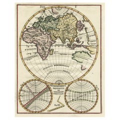
Antique map titled 'Hemisphere Meridional pour voir plus distinctement Les Terres Australes'. Hemispherical map of the southern hemisphere centered on the South Pole showing tracks of explorers, up to and including Cook's third and last voyage. Relief is shown pictorially.
Probably from a subsequent edition after 1782 after: Atlas geographiques et universel /? par Guil. de l'Isle et Phil. Buache. Paris: Dezauche.
- Creator:Guillaume De L'Isle (Artist)
- Dimensions:Height: 21.58 in (54.8 cm)Width: 29.93 in (76 cm)Depth: 0.02 in (0.5 mm)
- Materials and Techniques:Paper,Engraved
- Period:
- Date of Manufacture:circa 1783
- Condition:Wear consistent with age and use. Please study images carefully.
- Seller Location:Langweer, NL
- Reference Number:Seller: BG-021201stDibs: LU305438832933
About the Seller
5.0
Recognized Seller
These prestigious sellers are industry leaders and represent the highest echelon for item quality and design.
Platinum Seller
Premium sellers with a 4.7+ rating and 24-hour response times
Established in 2009
1stDibs seller since 2017
2,513 sales on 1stDibs
Typical response time: <1 hour
- ShippingRetrieving quote...Shipping from: Langweer, Netherlands
- Return Policy
Authenticity Guarantee
In the unlikely event there’s an issue with an item’s authenticity, contact us within 1 year for a full refund. DetailsMoney-Back Guarantee
If your item is not as described, is damaged in transit, or does not arrive, contact us within 7 days for a full refund. Details24-Hour Cancellation
You have a 24-hour grace period in which to reconsider your purchase, with no questions asked.Vetted Professional Sellers
Our world-class sellers must adhere to strict standards for service and quality, maintaining the integrity of our listings.Price-Match Guarantee
If you find that a seller listed the same item for a lower price elsewhere, we’ll match it.Trusted Global Delivery
Our best-in-class carrier network provides specialized shipping options worldwide, including custom delivery.More From This Seller
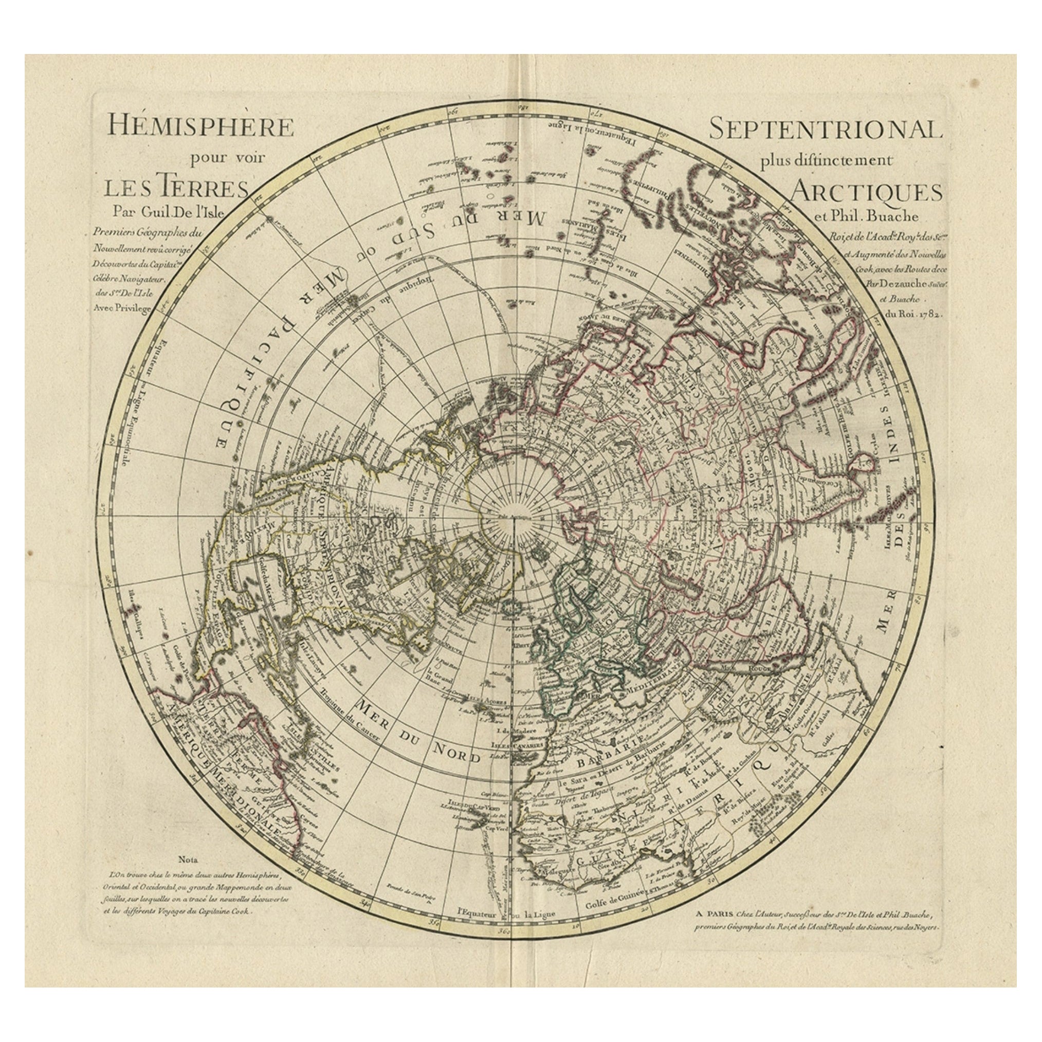
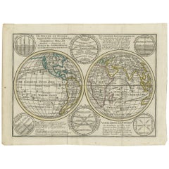
View AllAntique Map of the Northern Hemisphere, 1782
Located in Langweer, NL
Antique map titled 'Hémisphère Septentrional pour voir plus distinctement les Terres Arctiques (..)'.
Map of the Northern Hemisphere, originall...
Category
Antique 1780s Maps
Materials
Paper
$1,415 Sale Price
20% Off
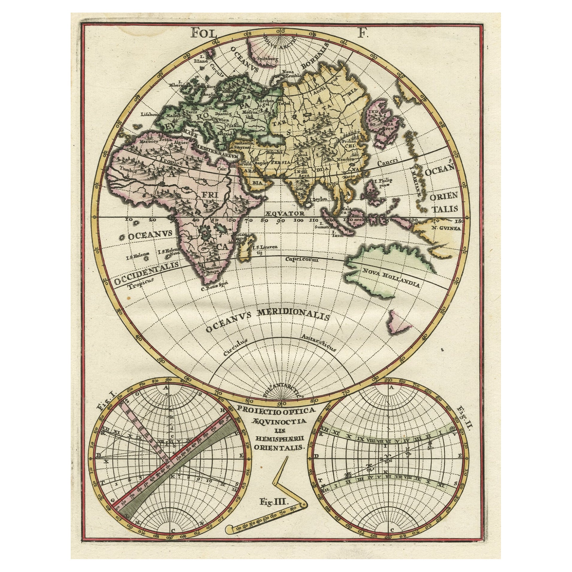
Original Antique Engraving of the Eastern Hemisphere, c.1700
Located in Langweer, NL
Antique map titled 'Proiectio Optica Aequinoctia lis Hemishaerii Orientalis' - Map of the Eastern Hemisphere with Africa, Europe, Asia and Nova Hollandia...
Category
Antique 17th Century Maps
Materials
Paper
$867 Sale Price
20% Off
Antique Map of the World in Hemispheres by Keizer & de Lat, 1788
Located in Langweer, NL
Antique map titled 'Schuine Ronde Aard-Bolle waar van 't Middelpunt is Amsterdam (..)'. Interesting double hemisphere world map on polar projections. In North America, there is a large Island of California. Australia and New Zealand are shown with incomplete coastlines. The map contains six smaller astronomical...
Category
Antique Late 18th Century Maps
Materials
Paper

$471 Sale Price
20% Off
Antique Map of the World with Polar Projections by Keizer & de Lat, 1788
Located in Langweer, NL
Antique map titled 'Schuine Ronde Aard-Klooten (..)'. Interesting double hemisphere world map with polar projections. In North America, there is a...
Category
Antique Late 18th Century Maps
Materials
Paper

$442 Sale Price
25% Off
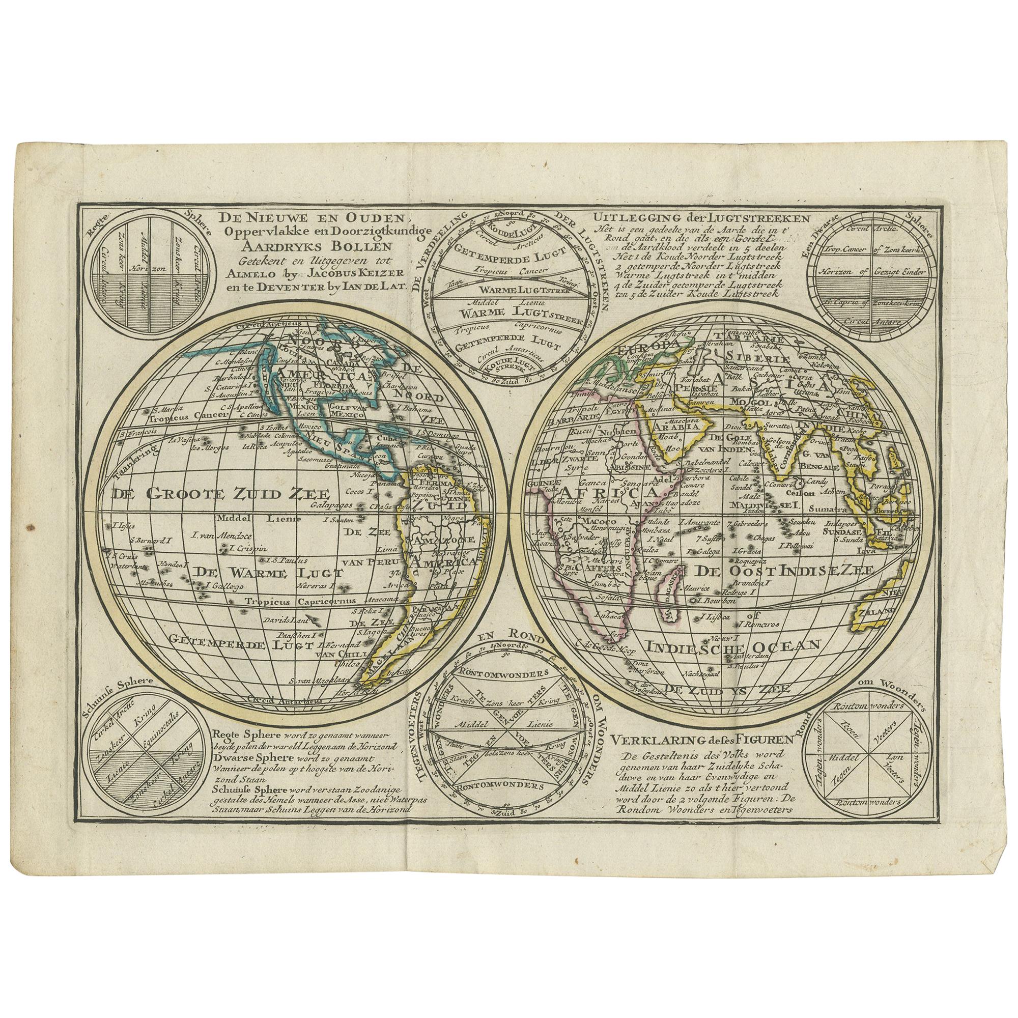
Interesting Antique Engraving of the World in Hemispheres with 6 Diagrams, 1788
Located in Langweer, NL
Antique map titled 'De Nieuwe en Ouden oppervlakke en doorzigtkundige Aardrykes Bollen (..)'. Twin hemispheres surrounded by six diagrams showing various divisions of the globe. Cali...
Category
Antique Late 18th Century Maps
Materials
Paper
$471 Sale Price
20% Off
Antique Map of the Northern Hemisphere and North Pole by Tirion, circa 1754
Located in Langweer, NL
Antique map titled 'Nieuwe Kaart van de Noord Pool na de alderlaatste ondekking int licht gebracht'. Map of the Northern Hemisphere and North Pole, which shows the NE Passage, but no...
Category
Antique Mid-18th Century Maps
Materials
Paper

$663 Sale Price
24% Off
You May Also Like
Original Antique Map of The Eastern Hemisphere by Dower, circa 1835
Located in St Annes, Lancashire
Nice map of the Eastern Hemisphere
Drawn and engraved by J.Dower
Published by Orr & Smith. C.1835
Unframed.
Free shipping
Category
Antique 1830s English Maps
Materials
Paper

Original Antique Map of The Western Hemisphere by Dower, circa 1835
Located in St Annes, Lancashire
Nice map of the Western Hemisphere
Drawn and engraved by J.Dower
Published by Orr & Smith. C.1835
Unframed.
Free shipping
Category
Antique 1830s English Maps
Materials
Paper

Original Antique Map of The World by Thomas Clerk, 1817
Located in St Annes, Lancashire
Great map of The Eastern and Western Hemispheres
On 2 sheets
Copper-plate engraving
Drawn and engraved by Thomas Clerk, Edinburgh.
Published by Mackenzie And Dent, 1817
...
Category
Antique 1810s English Maps
Materials
Paper

Original Antique Map of South America. C.1780
Located in St Annes, Lancashire
Great map of South America
Copper-plate engraving
Published C.1780
Two small worm holes to left side of map
Unframed.
Category
Antique Early 1800s English Georgian Maps
Materials
Paper

North & South America: A 17th Century Hand-colored Map by Jansson & Goos
By Johannes Janssonius
Located in Alamo, CA
A 17th century hand-colored map of North & South America entitled "Americae Descriptio" by the cartographer Johannes Jansson, published in Jansson's Atlas Minor in Amsterdam in 1628....
Category
Antique 1620s Dutch Maps
Materials
Paper

California, Alaska and Mexico: 18th Century Hand-Colored Map by de Vaugondy
By Didier Robert de Vaugondy
Located in Alamo, CA
This is an 18th century hand-colored map of the western portions of North America entitled "Carte de la Californie et des Pays Nord-Ouest separés de l'Asie par le détroit d'Anian, ex...
Category
Antique 1770s French Maps
Materials
Paper

More Ways To Browse
Gold Modern Coffee Table
Large Side Tables
Japanese Silver Ceramics
One Of A Kind Chair
Used Oak Dining Room Chairs
17th Century Plate
Childrens Vintage Poster
Chinese Ship
Vintage Travel Poster Mid Century
Desk Key
Woven Silk Art
Carved Cabriole Table
Dark Antique Table
White Wooden Table
Antique Wall Table
1960 Chair Wood Danish
Unusual Dining Table
Antique Dutch Plates