Items Similar to Amsterdam city plan - Joost van Sassen

Want more images or videos?
Request additional images or videos from the seller
1 of 7
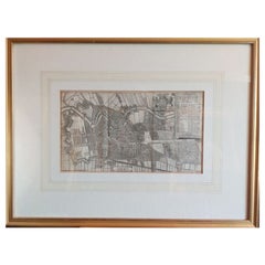
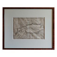
Amsterdam city plan - Joost van Sassen
$1,079.26
£802.86
€900
CA$1,477.88
A$1,643.20
CHF 857.99
MX$20,001.73
NOK 10,947.55
SEK 10,257.33
DKK 6,851.20
Shipping
Retrieving quote...The 1stDibs Promise:
Authenticity Guarantee,
Money-Back Guarantee,
24-Hour Cancellation
About the Item
“Afbeeldinge der Stad Amsterdam, gelyk deselve in den jaren 1536 door Cornelis Antonisz na ’t leven is geschildert, en Ao 1544 in druk uytgegeven.”, engraved by Joost van Sassen and published by Johannes van Septeren in Amsterdam in 1729. Size: 35,5 x 27,5 cm. Size including frame: 52 x 44,5 cm.
Anthonisz was a grandson of Jacob Cornelisz. van Oostsanen, who was probably also his teacher, and a cousin of Dirck Jacobsz. In 1538 he painted the first complete and (relatively) accurate map of Amsterdam, commissioned by the city as a gift for Emperor Charles V. He is best known for his woodcuts.
His most famous woodcut is the Vogelvlucht map of Amsterdam from 1544, which was printed with 12 blocks. This woodcut was very popular and was reprinted well into the seventeenth century, so there are several versions, such as a version with a Gothic initial D at the top right, one with a Latin initial D decorated with plant motifs (see image center right) and one with Latin initial D depicting King David (see image bottom right).
He also made many royal portraits and allegorical prints. Only two paintings can be attributed to him with certainty, both of which have been given on permanent loan by the city of Amsterdam to the Amsterdam Museum. According to the legend on his Vogelvlucht map, he lived “behind the Nieuwe Kerk” in “de Schrijvende handt”. A facing stone with a writing hand on it was the identification mark of writers, booksellers and mapmakers.
- Dimensions:Height: 17.52 in (44.5 cm)Width: 20.48 in (52 cm)Depth: 0.79 in (2 cm)
- Style:Other (In the Style Of)
- Materials and Techniques:
- Place of Origin:
- Period:1720-1729
- Date of Manufacture:1729
- Condition:Wear consistent with age and use.
- Seller Location:UTRECHT, NL
- Reference Number:1stDibs: LU6566238893152
About the Seller
No Reviews Yet
Vetted Professional Seller
Every seller passes strict standards for authenticity and reliability
Established in 2014
1stDibs seller since 2022
- ShippingRetrieving quote...Shipping from: UTRECHT, Netherlands
- Return Policy
Authenticity Guarantee
In the unlikely event there’s an issue with an item’s authenticity, contact us within 1 year for a full refund. DetailsMoney-Back Guarantee
If your item is not as described, is damaged in transit, or does not arrive, contact us within 7 days for a full refund. Details24-Hour Cancellation
You have a 24-hour grace period in which to reconsider your purchase, with no questions asked.Vetted Professional Sellers
Our world-class sellers must adhere to strict standards for service and quality, maintaining the integrity of our listings.Price-Match Guarantee
If you find that a seller listed the same item for a lower price elsewhere, we’ll match it.Trusted Global Delivery
Our best-in-class carrier network provides specialized shipping options worldwide, including custom delivery.More From This Seller
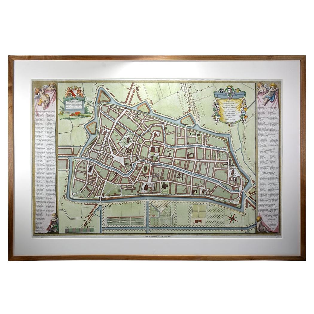
View AllUtrecht city plan
Located in UTRECHT, UT
“Platte grond der Stad Utrecht vertonende alle Gragten, Straaten, Stegen, Gangen, Markten, en plaatsen der openbare Gebouwen”, engraving published by Johannes van Schoonhoven in Amst...
Category
Antique 1770s Dutch Other Maps
Materials
Paper

$3,897
Curaçao map - C. van Baarsel en zoon
Located in UTRECHT, UT
“Kaart van het eiland Curaçao.”, “Algemeene kaart der Caraïbische eilanden”, “Plan van het fort Amsterdam op Curaçao” from the atlas “Atlas der overzeesche bezittingen van Zijne Maje...
Category
Antique 1810s Dutch Other Maps
Materials
Paper
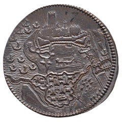
1593. Beleg van Geertruidenberg
Located in UTRECHT, UT
Obverse: Geertruidenberg under siege by the armies of prince Maurice by land and by water
Reverse: .*. / GERTRVDIS / BERGA. AB. HISP. / VINDICANT. ORD / CONFŒD. DVCE. PRIN / NASS. IN...
Category
Antique 16th Century Dutch Antiquities
Materials
Silver
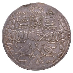
1621. Golden wedding anniversary Maarten Ruychaver and Aleyd van der Laen
Located in UTRECHT, UT
Obverse: ANNO – 1570 / .M. – .R. / .28. – OCTO, clasped hands coming out of the clouds, above the wedding date and the initials and coat of arms of Maarten Ruychaver, below two turtl...
Category
Antique 1620s Dutch Neoclassical Antiquities
Materials
Silver
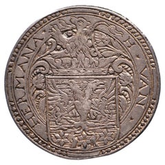
N.d. Marriage Hessel van Hermane & Anna van Lyauckema
Located in UTRECHT, UT
Obverse: H ✶ VAN ✶ – HERMANA ✶, crowned coat of arms with lion crest
Reverse: ✶ A ✶ VAN ✶ – ✶ LYAUCKEMA ✶, crowned diamond-shaped coat of arms
Earliest known Dutch wedding medal and...
Category
Antique 16th Century Other Antiquities
Materials
Silver
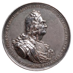
Ferdinand van Collen, administrator of WIC, mayor of Amsterdam
Located in UTRECHT, UT
Obverse: FERDIN. VAN. COLLEN.TOPARCH. DE. GUNTERSTEIN. DOM. IN. TIENHOVEN. PRAETOR. ET. SENATOR. AMSTEL, armoured and draped bust of Ferdinand van Collen
Reverse: AD. CONFOEDERATOR. ...
Category
Antique Early 1700s Dutch Antiquities
Materials
Silver
You May Also Like
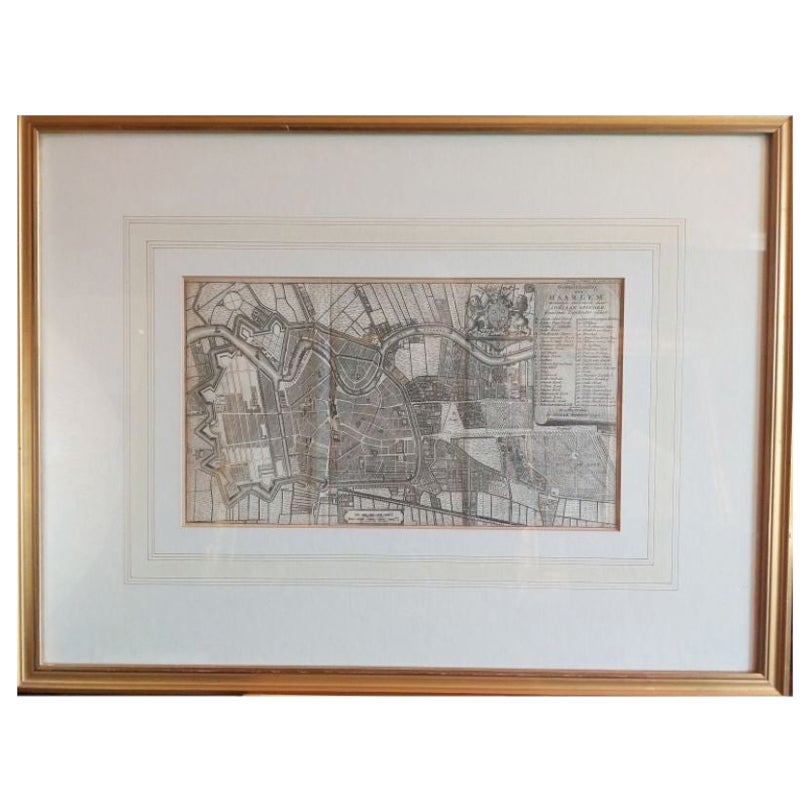
Antique Map of the City of Haarlem by Tirion, 1742
By Isaak Tirion
Located in Langweer, NL
Antique map titled 'Grondtekening van Haarlem (..)'. Original antique map of the city of Haarlem, the Netherlands. Published by I. Tirion, 1742.
Artists and Engravers: Isaak Tirio...
Category
Antique 18th Century Maps
Materials
Paper
$211 Sale Price
20% Off
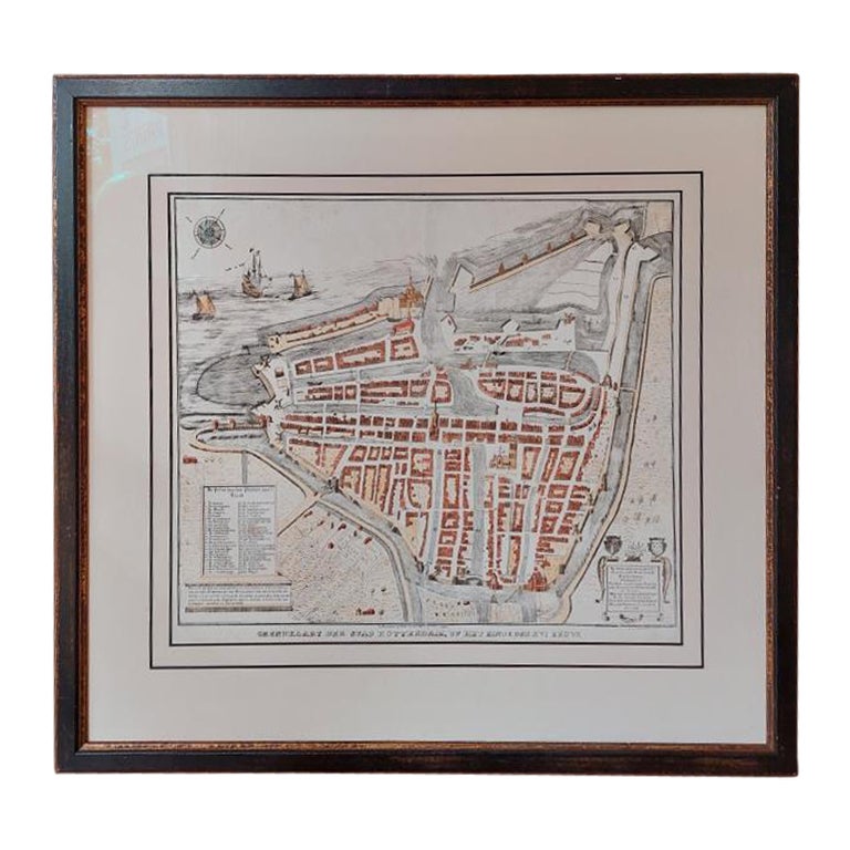
Antique City Plan of Rotterdam in Frame, ca.1850
Located in Langweer, NL
Antique map titled 'Grondkaart der stad Rotterdam (..)'. Original antique city plan of Rotterdam, the Netherlands. Published circa 1850.
Artists...
Category
Antique 19th Century Prints
Materials
Paper

$623 Sale Price
20% Off
Framed 1731 Color Engraving, Map of Rotterdam by Matthaus Seutter, "Roterodami"
Located in Bridgeport, CT
"Roterodami". Seutter (1678-1757) was an important German 18th century map maker. Bird's eye view of the city above with full details, neoclassi...
Category
Antique 18th Century European Renaissance Maps
Materials
Glass, Wood, Paper

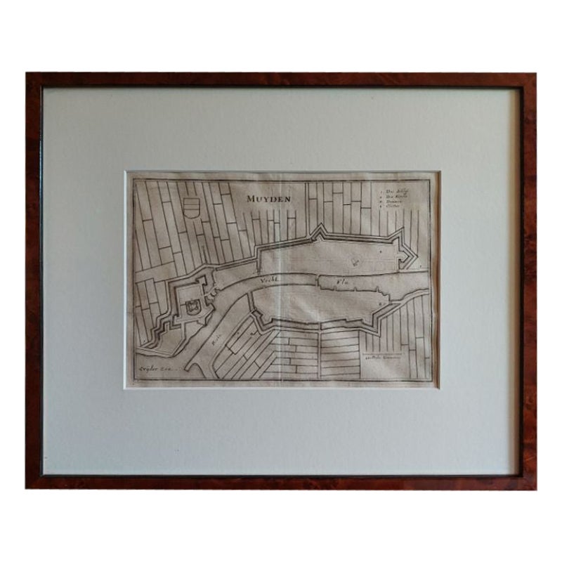
Antique Map of the City of Muiden by Merian, 1659
Located in Langweer, NL
Antique map titled 'Muyden'. Original antique map of the city of Muiden, the Netherlands. This map originates from 'Topographia Germania Inferioris' by C. Merian. Published 1659.
...
Category
Antique 17th Century Maps
Materials
Paper
$148 Sale Price
20% Off
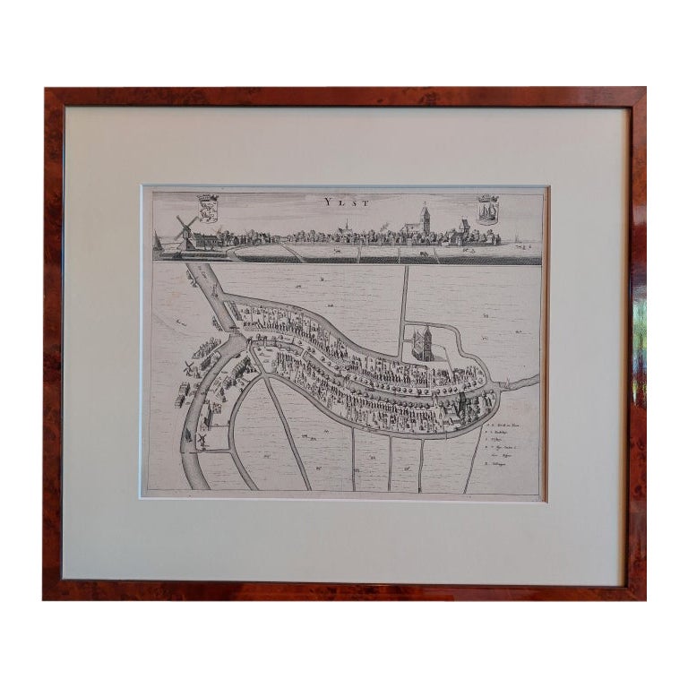
Antique City View and Map of IJlst, City in Friesland, Holland, Framed, 1664
Located in Langweer, NL
Antique map titled 'Ylst'. Old map and city view of the city of IJlst, Friesland. This map originates from 'Beschrijvinge van de Heerlyckheydt van Frieslandt' by B. Schotanus à Sterr...
Category
Antique 17th Century Maps
Materials
Paper

$479 Sale Price
20% Off
Antique Map of the City of Leeuwarden by Harrewijn, 1743
Located in Langweer, NL
Antique map titled 'La Ville de Lewarde'. Old map of the city of Leeuwarden, Friesland. Originates from 'Les Délices des Pays-Bas' by Widow Foppens.
Artists and Engravers: Engrav...
Category
Antique 18th Century Maps
Materials
Paper
$118 Sale Price
20% Off
More Ways To Browse
20th Century Spanish Table
Antonio Bellini
Antique Oushak Carpets
Blue Coffee Tables
German Bauhaus Posters
1945 Chair Juhl
Antique Three Leg Table
Folke Arstrom
Silver Over Copper
Vintage Barware Glasses
Antique Etched Glass
Antique French Shell
Coffee Table Black Italian Modern
Christofle America
Iranian Silk Rug Carpet
Poul Moller
Tables With Inlaid Wood
World War Table