Items Similar to Antique 19th Century Map of Ancient Syria & Assyria - Historical Regions, c.1802
Want more images or videos?
Request additional images or videos from the seller
1 of 7
Antique 19th Century Map of Ancient Syria & Assyria - Historical Regions, c.1802
$292.47
$365.5920% Off
£218.92
£273.6520% Off
€248
€31020% Off
CA$402.52
CA$503.1520% Off
A$448.65
A$560.8120% Off
CHF 235.39
CHF 294.2420% Off
MX$5,478.75
MX$6,848.4420% Off
NOK 2,980.57
NOK 3,725.7120% Off
SEK 2,817.09
SEK 3,521.3620% Off
DKK 1,887.95
DKK 2,359.9420% Off
About the Item
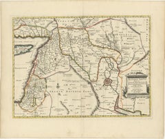
19th Century Map of Ancient Syria and Assyria: 'Tabula Regiones inter Syriam et Assyriam continens'"*
This beautifully detailed 18th-century map, titled *"Tabula Regiones inter Syriam et Assyriam continens,"* offers a scholarly depiction of the regions between ancient Syria and Assyria. The map highlights key geographical features of these historically significant lands, covering areas that correspond to parts of modern-day Iraq, Syria, and surrounding regions.
Engraved with precision, this map showcases important cities and landmarks of the time, such as Babylon, Seleucia, and Damascus, along with major rivers like the Tigris and Euphrates. The map also delineates various ancient regions, including Mesopotamia, Phoenicia, and Elymais, making it an invaluable resource for historians and collectors alike.
The map is attributed to a distinguished cartographer of the era, reflecting the detailed knowledge and cartographic skills of its maker. It was likely included in an atlas or historical compendium dedicated to the study of ancient empires and their geographical contexts.
With noticeable but typical signs of aging, including some foxing and minor edge wear, this map remains in good condition and continues to be a testament to the rich history and cartographic expertise of the 18th century.
This map is an excellent addition for collectors of historical maps, students of ancient history, or anyone with an interest in the classical world. Please refer to the detailed photographs provided for a closer inspection of this exquisite piece.
T. Conder, or Thomas Conder, was a well-known British engraver and mapmaker active during the late 18th and early 19th centuries. The term "Sculpsit" (Latin for "he/she carved it") often follows the name of the engraver on historical maps and prints, indicating that the person named was responsible for engraving the work.
Thomas Conder was particularly known for his work on maps and illustrations that appeared in various atlases and historical books of the period. He worked with several notable publishers and cartographers, contributing to the production of high-quality engravings that were valued for their precision and detail. His work is often associated with the Georgian period in Britain, and his engravings are found in various historical and geographical publications from that time.
Given that the map was engraved by T. Conder, it is likely from a publication produced in the late 18th or early 19th century. Thomas Conder worked extensively on maps and illustrations for various atlases and historical works during this period.
One possible source for this map could be "The Complete Genealogical, Historical, Chronological, and Geographical Atlas", which was published in 1790. Another potential source is "Middle Eastern and Classical Maps", which were part of historical or classical texts printed around that time.
To pinpoint the exact publication and year, you would typically look for additional details such as the title of the map, the specific content it covers (regions, historical events, etc.), and any accompanying text or references. However, based on Conder's active period and the style of the engraving, a likely publication date for this map could be anywhere between **1780 and 1820**.
Without more specific information, a precise identification might be challenging, but the above provides a reasonable context and potential publication period. More research needed.
- Dimensions:Height: 14.02 in (35.6 cm)Width: 19.69 in (50 cm)Depth: 0 in (0.02 mm)
- Materials and Techniques:
- Period:
- Date of Manufacture:circa 1802
- Condition:With noticeable but typical signs of aging, including some foxing, light offset and minor edge wear, this map remains in good condition. Vertical folding lines as issued. A brownish hue overal, adding to its patina.
- Seller Location:Langweer, NL
- Reference Number:Seller: BG-13746-161stDibs: LU3054341024422
About the Seller
5.0
Recognized Seller
These prestigious sellers are industry leaders and represent the highest echelon for item quality and design.
Platinum Seller
Premium sellers with a 4.7+ rating and 24-hour response times
Established in 2009
1stDibs seller since 2017
2,517 sales on 1stDibs
Typical response time: <1 hour
- ShippingRetrieving quote...Shipping from: Langweer, Netherlands
- Return Policy
Authenticity Guarantee
In the unlikely event there’s an issue with an item’s authenticity, contact us within 1 year for a full refund. DetailsMoney-Back Guarantee
If your item is not as described, is damaged in transit, or does not arrive, contact us within 7 days for a full refund. Details24-Hour Cancellation
You have a 24-hour grace period in which to reconsider your purchase, with no questions asked.Vetted Professional Sellers
Our world-class sellers must adhere to strict standards for service and quality, maintaining the integrity of our listings.Price-Match Guarantee
If you find that a seller listed the same item for a lower price elsewhere, we’ll match it.Trusted Global Delivery
Our best-in-class carrier network provides specialized shipping options worldwide, including custom delivery.More From This Seller
View AllAntique Map of the Middle East by Smith, 1809
Located in Langweer, NL
Antique map titled 'Regiones inter Euphraten et Indum'. Old map of the Middle East showing the region between the Euphrates and Indus river. Ori...
Category
Antique 19th Century Maps
Materials
Paper
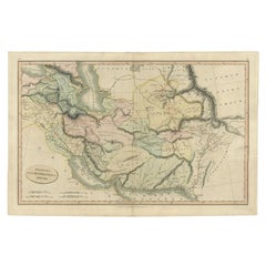
$125 Sale Price
20% Off
Antique Map of Eastern Turkey, Caucasus, Israel through Iraq and part of Arabia
Located in Langweer, NL
Antique map titled 'Nieuwe Kaart van Irak Arabia, Kurdistan, Diarbek, Turkomannia, Syrie en het Heilige Land'. Beautiful map including eastern Turkey, the Caucasus, Israel through Ir...
Category
Antique Mid-18th Century Maps
Materials
Paper

$428 Sale Price
20% Off
Antique Map of Asian Turkey, Levant, and Mesopotamia by Tardieu, circa 1802
Located in Langweer, NL
This is an original antique map titled "Carte de la Turquie Asiatique," depicting the Asian territories of the Ottoman Empire. Created by Pierre Antoine Tardieu, this map illustrates...
Category
Antique Early 1800s Maps
Materials
Paper
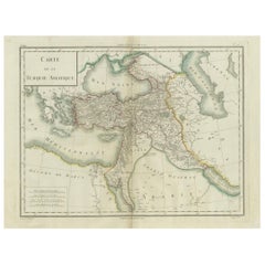
$410 Sale Price
20% Off
Old Map of Ancient Assyria Divided into Syria, Mesopotamia, Babylonia & Assyria
Located in Langweer, NL
This map, "Assyria vetus diuisa in Syriam, Messopotamiam, Babyloniam, et Assyriam", by Pierre Mortier, is a late 17th-century depiction of the historical Middle East.
Title: Ancie...
Category
Antique Early 1700s Maps
Materials
Paper
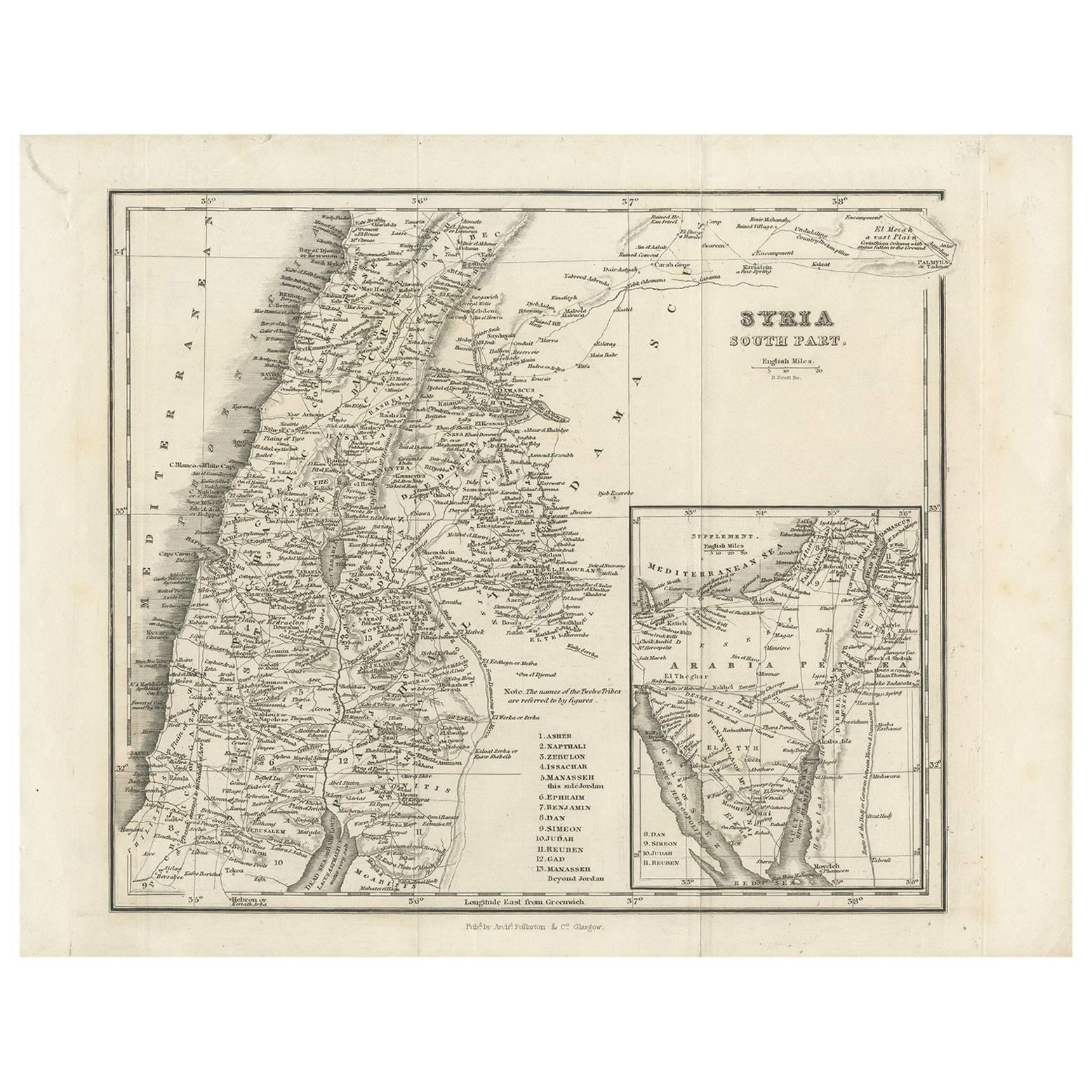
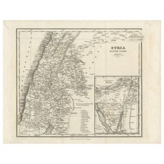
Antique Map of Southern Syria by Fullarton & Co, circa 1860
Located in Langweer, NL
Antique map titled 'Syria south part'. Published by Fullarton & Co, Glasgow, circa 1860.
- Title: Syria South Part
- Publisher: Fullarton & Co, Glasgow
- Date of Publication: Circa ...
Category
Antique Mid-19th Century English Maps
Materials
Paper
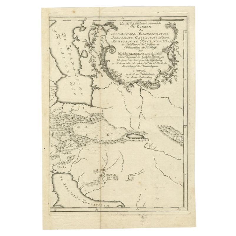
Antique Map of Ancient Persia, Assyria and surroundings, c.1760
Located in Langweer, NL
Antique map titled 'De XII de Landkaart vertoonende de Landen der Assyrische, Babylonische, Persische, Grieksche en daarna Romeinsche Heerschappy.' Map of ancient Persia...
Category
Antique 18th Century Maps
Materials
Paper
$316 Sale Price
20% Off
You May Also Like
Circa 1825 original engraving of the map of Syria by Giraldon Bovinet
Located in PARIS, FR
The circa 1825 original engraving of "Syrie" by Giraldon Bovinet, based on the work of L. Vivien, is a historically significant map that reflects early 19th-century cartographic tech...
Category
1820s Prints and Multiples
Materials
Engraving, Paper

Original Antique Map of Ancient Greece, Achaia, Corinth, 1786
Located in St Annes, Lancashire
Great map of Ancient Greece. Showing the region of Thessaly, including Mount Olympus
Drawn by J.D. Barbie Du Bocage
Copper plate engraving by P.F Tardieu
Original hand color...
Category
Antique 1780s French Other Maps
Materials
Paper

Map of the Holy Land "Carte de la Syrie et de l'Egypte" by Pierre M. Lapie
By Pierre M. Lapie
Located in Alamo, CA
An early 19th century map of ancient Syria and Egypt entitled "Carte de la Syrie et de l'Egypte anciennes/dressée par M. Lapie, Colonel d'Etat Major, et...
Category
Antique Early 19th Century French Maps
Materials
Paper

Persia, Armenia & Adjacent Regions: A 17th Century Hand-colored Map by De Wit
By Frederick de Wit
Located in Alamo, CA
A large 17th century hand colored copperplate engraved map entitled "Novissima nec non Perfectissima Scandinaviae Tabula comprehendens Regnorum Sueciae, Daniae et Norvegiae distincte...
Category
Antique Late 17th Century Dutch Maps
Materials
Paper

Large Original Antique Map of Morocco. Edward Weller, 1861
Located in St Annes, Lancashire
Great map of Morocco
Lithograph engraving by Edward Weller
Original colour
Published, 1861
Unframed
Good condition.
Category
Antique 1860s English Victorian Maps
Materials
Paper

Original Antique Map of Ancient Greece- Boeotia, Thebes, 1787
Located in St Annes, Lancashire
Great map of Ancient Greece. Showing the region of Boeotia, including Thebes
Drawn by J.D. Barbie Du Bocage
Copper plate engraving by P.F T...
Category
Antique 1780s French Other Maps
Materials
Paper

More Ways To Browse
Antique Syrian
Antique Compendium
Antique Ancient Key
Antique Syrian Furniture
Damascus Furniture
Antique Damascus
Ancient Babylon
Thomas Day Furniture Late 1800
Coffee Table Black Italian Modern
Christofle America
Iranian Silk Rug Carpet
Poul Moller
Tables With Inlaid Wood
World War Table
Antonio Jacobsen
Ariston Chairs
Coffee Tables Europe
Marble Top Dining Tables