Items Similar to Antique French Engraving of Mexico with Lots of Details, c.1780


Want more images or videos?
Request additional images or videos from the seller
1 of 5
Antique French Engraving of Mexico with Lots of Details, c.1780
$330.81
$413.5120% Off
£247.96
£309.9520% Off
€280
€35020% Off
CA$454.47
CA$568.0920% Off
A$507.38
A$634.2220% Off
CHF 265.86
CHF 332.3220% Off
MX$6,210.77
MX$7,763.4720% Off
NOK 3,376.39
NOK 4,220.4920% Off
SEK 3,183.51
SEK 3,979.3820% Off
DKK 2,131.46
DKK 2,664.3320% Off
Shipping
Retrieving quote...The 1stDibs Promise:
Authenticity Guarantee,
Money-Back Guarantee,
24-Hour Cancellation
About the Item
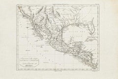
Antique map titled 'Partie Meridionale, de L'Ancien Mexique ou de la Nouvelle Espagne.'
Detailed map of Mexico, the Yucatan and Central America, prepared under the direction of Rigobert Bonne. Shows towns, rivers, mountains, lakes, etc. Detailed map of the region. Source unknown, to be determined.
Artists and Engravers: Rigobert Bonne (1727-1795 ) was one of the most important cartographers of the late 18th century. In 1773 he succeeded Jacques Bellin as Royal Cartographer to France in the office of the Hydrographer at the Depôt de la Marine. Working in his official capacity Bonne compiled some of the most detailed and accurate maps of the period. Bonne's work represents an important step in the evolution of the cartographic ideology away from the decorative work of the 17th and early 18th century towards a more detail oriented and practical aesthetic. With regard to the rendering of terrain Bonne maps bear many stylistic similarities to those of his predecessor, Bellin. However, Bonne maps generally abandon such common 18th century decorative features such as hand coloring, elaborate decorative cartouches, and compass roses. While mostly focusing on coastal regions, the work of Bonne is highly regarded for its detail, historical importance, and overall aesthetic appeal.
Artist: Rigobert Bonne (1727-1795 ) was one of the most important cartographers of the late 18th century. In 1773 he succeeded Jacques Bellin as Royal Cartographer to France in the office of the Hydrographer at the Depôt de la Marine. Working in his official capacity Bonne compiled some of the most detailed and accurate maps of the period. Bonne's work represents an important step in the evolution of the cartographic ideology away from the decorative work of the 17th and early 18th century towards a more detail oriented and practical aesthetic. With regard to the rendering of terrain Bonne maps bear many stylistic similarities to those of his predecessor, Bellin. However, Bonne maps generally abandon such common 18th century decorative features such as hand coloring, elaborate decorative cartouches, and compass roses. While mostly focusing on coastal regions, the work of Bonne is highly regarded for its detail, historical importance, and overall aesthetic appeal.
Condition: Good, given age. Slight discolouration middle fold. Original folds as issued. General age-related toning and/or occasional minor defects from handling. Please study image carefully.
Date: c.1780
Overall size: 38 x 26 cm.
Image size: 31.8 x 22 cm.
- Dimensions:Height: 14.97 in (38 cm)Width: 10.24 in (26 cm)Depth: 0 in (0.01 mm)
- Materials and Techniques:
- Period:
- Date of Manufacture:circa 1780
- Condition:
- Seller Location:Langweer, NL
- Reference Number:Seller: PCT-615791stDibs: LU3054326383232
About the Seller
5.0
Recognized Seller
These prestigious sellers are industry leaders and represent the highest echelon for item quality and design.
Platinum Seller
Premium sellers with a 4.7+ rating and 24-hour response times
Established in 2009
1stDibs seller since 2017
2,511 sales on 1stDibs
Typical response time: <1 hour
- ShippingRetrieving quote...Shipping from: Langweer, Netherlands
- Return Policy
Authenticity Guarantee
In the unlikely event there’s an issue with an item’s authenticity, contact us within 1 year for a full refund. DetailsMoney-Back Guarantee
If your item is not as described, is damaged in transit, or does not arrive, contact us within 7 days for a full refund. Details24-Hour Cancellation
You have a 24-hour grace period in which to reconsider your purchase, with no questions asked.Vetted Professional Sellers
Our world-class sellers must adhere to strict standards for service and quality, maintaining the integrity of our listings.Price-Match Guarantee
If you find that a seller listed the same item for a lower price elsewhere, we’ll match it.Trusted Global Delivery
Our best-in-class carrier network provides specialized shipping options worldwide, including custom delivery.More From This Seller
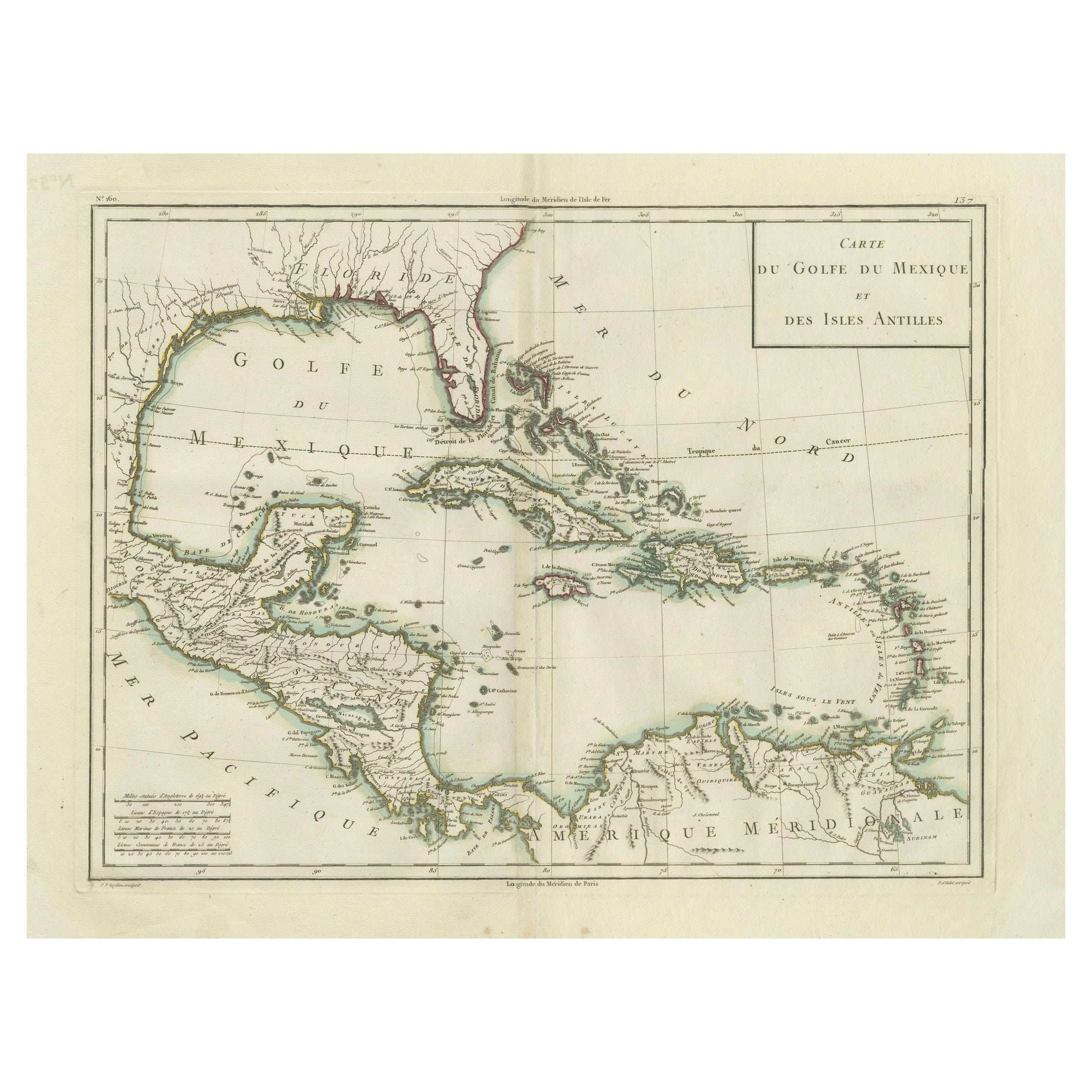
View AllOriginal Engraving of the West Indies, Gulf of Mexico, Antilles, Caribbean, 1780
Located in Langweer, NL
Rigobert Bonne and G. Raynal's 1780 map of the West Indies, Gulf of Mexico, Antilles, and the Caribbean stands as a remarkable cartographic piece, offering a detailed and expansive v...
Category
Antique Late 18th Century Maps
Materials
Paper
$368 Sale Price
20% Off
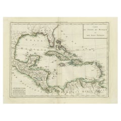
Antique Map of the Gulf of Mexico and Caribbean Islands by Tardieu, 1802
Located in Langweer, NL
This is an original antique map titled "Carte du Golfe du Mexique et des Isles Antilles," depicting the Gulf of Mexico and the Caribbean islands. Created by Pierre Antoine Tardieu, t...
Category
Antique Early 1800s Maps
Materials
Paper
$529 Sale Price
20% Off
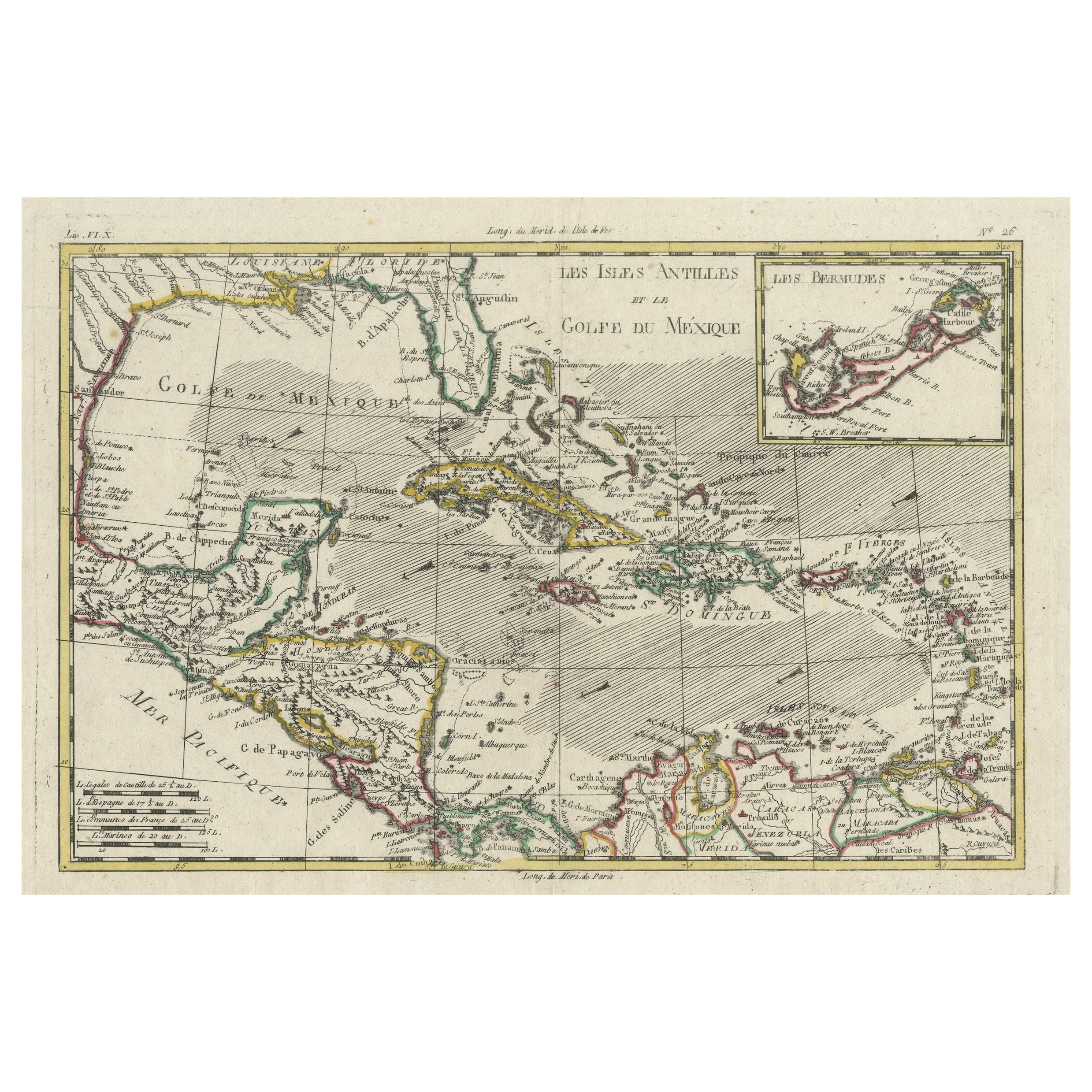
Authentic Antique Map of the Caribbean, Gulf Coast and Central America, 1787
Located in Langweer, NL
Antique map titled 'Les Isles Antilles et le Golfe du Méxique'. Original old map of the Caribbean, Gulf Coast and Central America. With inset map of Bermuda...
Category
Antique Late 18th Century Maps
Materials
Paper

$293 Sale Price
20% Off
Free Shipping
Antique Map of South America Depicting Guayana, c.1780
Located in Langweer, NL
Antique map titled 'La Guyane Francopise avec partie de la Guyane Hollandoise: suivant les Operations et les Cartes recentes des Ingenieurs-Geographes Francois'. Antique map of South...
Category
Antique 18th Century Maps
Materials
Paper

$330 Sale Price
20% Off
Antique Map of Northern Brazil by Bonne, c.1780
Located in Langweer, NL
Antique map titled 'Carte de la Partie Septentrionale du Bresil.' Detailed map of the northern portion of Brazil from Bahia to French Guiana, showing the eastern Amazon interior rivers, Mission Territories, Goyza and the coastal regions, including coastal currents. Source unknown, to be determined. Artists and Engravers: Rigobert Bonne (1727-1795 ) was one of the most important cartographers of the late 18th century. In 1773 he succeeded Jacques Bellin as Royal Cartographer to France in the office of the Hydrographer at the Depôt de la Marine. Working in his official capacity Bonne compiled some of the most detailed and accurate maps of the period. Bonne's work represents an important step in the evolution of the cartographic ideology away from the decorative work of the 17th and early 18th century towards a more detail oriented and practical aesthetic. With regard to the rendering of terrain Bonne maps...
Category
Antique 18th Century Maps
Materials
Paper

$118 Sale Price
20% Off
Antique French Map of Java, Indonesia by Chatelain, '1719'
Located in Langweer, NL
Antique map titled 'Carte de l'Ile de Java: Partie Occidentale, Partie Orientale, Dressee tout Nouvellement Sur Les Memoires Les Plus Exacts (..)'. This beautiful map of Java (Indone...
Category
Antique Early 18th Century Maps
Materials
Paper

$2,646 Sale Price
20% Off
You May Also Like
Original Antique Map of South America. C.1780
Located in St Annes, Lancashire
Great map of South America
Copper-plate engraving
Published C.1780
Two small worm holes to left side of map
Unframed.
Category
Antique Early 1800s English Georgian Maps
Materials
Paper

Ancient Map of Mexico - Original Etching - 19th Century
Located in Roma, IT
This Map of Mexico is an etching realized in 19th century.
The state of preservation of the artwork is good with some small missing papers on the right angles. At the top of the pap...
Category
19th Century More Prints
Materials
Etching
West Coast of Africa, Guinea & Sierra Leone: An 18th Century Map by Bellin
By Jacques-Nicolas Bellin
Located in Alamo, CA
Jacques Bellin's copper-plate map entitled "Partie de la Coste de Guinee Dupuis la Riviere de Sierra Leona Jusquau Cap das Palmas", depicting the coast of Guinea and Sierra Leone in ...
Category
Antique Mid-18th Century French Maps
Materials
Paper

West Africa Entitled "Guinea Propria": An 18th Century Hand Colored Homann Map
By Johann Baptist Homann
Located in Alamo, CA
This is a scarce richly hand colored copper plate engraved map of Africa entitled "Guinea Propria, nec non Nigritiae vel Terrae Nigrorum Maxima Pars" by Johann Baptist Homann (1664-1...
Category
Antique Mid-18th Century German Maps
Materials
Paper

Original Antique Map of Central America / Florida, Arrowsmith, 1820
Located in St Annes, Lancashire
Great map of Central America.
Drawn under the direction of Arrowsmith.
Copper-plate engraving.
Published by Longman, Hurst, Rees, Orme and Brown, 1820
Unframed.
Category
Antique 1820s English Maps
Materials
Paper

Antique French Map of Asia Including China Indoneseia India, 1783
Located in Amsterdam, Noord Holland
Very nice map of Asia. 1783 Dedie au Roy.
Additional information:
Country of Manufacturing: Europe
Period: 18th century Qing (1661 - 1912)
Condition: Overall Condition B (Good Used)...
Category
Antique 18th Century European Maps
Materials
Paper

$648 Sale Price
20% Off
More Ways To Browse
Mexican Antiques
Mexican 18th Century Furniture
Used Marine Compass
Antique Marine Compass
Map Of Holy Land
Antique Macedonia
Antique Maps Of New York City
Victorian Compass
Antique Maps Caribbean Islands
Hungary Map
Cartographer Tool
Goa Furniture
George Fleet
Sri Lanka Map
Philippines Map
Antique Map Ceylon
Antique Sri Lanka Map
Persian Maps