Items Similar to Antique Map of the Americas and West Indies by Robert de Vaugondy, 1778


Want more images or videos?
Request additional images or videos from the seller
1 of 10
Antique Map of the Americas and West Indies by Robert de Vaugondy, 1778
$1,333.39
$1,777.8525% Off
£992.70
£1,323.6025% Off
€1,125
€1,50025% Off
CA$1,837.21
CA$2,449.6125% Off
A$2,045.73
A$2,727.6425% Off
CHF 1,081.83
CHF 1,442.4425% Off
MX$24,895.29
MX$33,193.7225% Off
NOK 13,636.71
NOK 18,182.2825% Off
SEK 12,847.79
SEK 17,130.3825% Off
DKK 8,564.09
DKK 11,418.7925% Off
About the Item
Antique Map of the Americas and West Indies by Robert de Vaugondy, 1778
This detailed antique map titled "Amérique ou Indes Occidentales" was published in 1778 by the renowned French cartographer Robert de Vaugondy. It offers a richly informative and speculative depiction of the Americas just before the era of scientific mapping brought about by the voyages of Captain Cook. Drawn during the Age of Enlightenment, this map captures both the growing accuracy of geographic knowledge and the persistence of long-held myths and theories about unexplored regions.
The map displays North and South America in full, accompanied by two large insets of Martinique and Saint-Domingue (now Haiti). These inset maps are finely engraved, showing settlements, rivers, fortifications, and coastal details, reflecting France's strong colonial and economic interest in the Caribbean during the 18th century.
A particularly intriguing aspect of the map is the treatment of the Pacific Northwest. The coastline is dramatically extended to the west, with numerous mythical rivers running from the Pacific inland. Among these is the legendary "Rivière de l’Ouest" (River of the West), a long-theorized water route connecting the Pacific Ocean to the interior of the continent, eventually joining the Mississippi River. These speculative waterways reflect the enduring influence of reports from explorers such as Admiral De Fonte and Martin d’Aguilar. In the southwestern part of North America, more hypothetical branches of these rivers wind across regions yet to be fully explored or mapped.
In addition to geographic detail, the map includes a genealogical chart on the right-hand side, outlining colonial possessions and political divisions among the European powers in the Americas. This gives the map both a geographic and colonial administrative dimension, offering valuable insight into how Europe viewed and structured the New World in the late 18th century.
Condition report:
Good condition overall. The map has light vertical folding, as issued, with some minor restoration along the centerfold. Faint spotting may be present, especially in the upper areas. Paper remains stable, and the impressions are clear and legible. Insets are sharply rendered.
Framing tips:
Given the refined black-and-white engraving and touches of hand-coloring, a dark walnut or black wood frame would complement the piece well. An ivory or antique white mat will help draw focus to the map's fine lines and cartouches. Use museum glass to protect the paper and preserve the crisp detailing. This map is a strong decorative and scholarly piece, ideal for display in libraries, studies, offices, or history-themed interiors.
- Dimensions:Height: 20.87 in (53 cm)Width: 27.56 in (70 cm)Depth: 0.02 in (0.5 mm)
- Materials and Techniques:Paper,Engraved
- Place of Origin:
- Period:
- Date of Manufacture:1778
- Condition:Replacements made: Good condition overall. The map has light vertical folding, as issued, with some minor restoration along the centerfold. Faint spotting may be present, especially in the upper areas. Paper remains stable, and the impressions are clear and legible. Repaired: General age related toning and light staining. Worm holes at lower middle fold and bottom margin; paper separation lower middle fold, backed by identical paper. Irregular paper edges, chipped with small tears, backed by identical paper. General age related toning and light staining. Shows some creasing and wear. Please study images carefully.
- Seller Location:Langweer, NL
- Reference Number:Seller: PCT-373261stDibs: LU3054321365832
About the Seller
5.0
Recognized Seller
These prestigious sellers are industry leaders and represent the highest echelon for item quality and design.
Platinum Seller
Premium sellers with a 4.7+ rating and 24-hour response times
Established in 2009
1stDibs seller since 2017
2,567 sales on 1stDibs
Typical response time: <1 hour
- ShippingRetrieving quote...Shipping from: Langweer, Netherlands
- Return Policy
Authenticity Guarantee
In the unlikely event there’s an issue with an item’s authenticity, contact us within 1 year for a full refund. DetailsMoney-Back Guarantee
If your item is not as described, is damaged in transit, or does not arrive, contact us within 7 days for a full refund. Details24-Hour Cancellation
You have a 24-hour grace period in which to reconsider your purchase, with no questions asked.Vetted Professional Sellers
Our world-class sellers must adhere to strict standards for service and quality, maintaining the integrity of our listings.Price-Match Guarantee
If you find that a seller listed the same item for a lower price elsewhere, we’ll match it.Trusted Global Delivery
Our best-in-class carrier network provides specialized shipping options worldwide, including custom delivery.More From This Seller
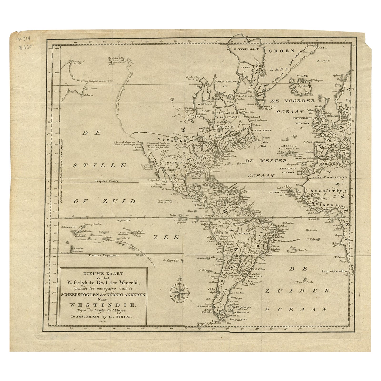
View AllExcellent Antique Map of America with Unusual Northwest Coast of America, c.1754
Located in Langweer, NL
Description: Antique map titled 'Nieuwe Kaart Van het Westelykste Deel Der Weereld, dienende tot aanwyzing an de Scheepstogten der Nederlanderne Naar West Indie.' Excellent map of America, featuring an unusual northwest coast of America, which includes Martin d'Aguilar's strait which provides for a Northwest Passage via the Great Lakes. The rest of the NW coast...
Category
Antique 1750s Maps
Materials
Paper
$545 Sale Price
20% Off
Antique Map of South America by J. Cook, 1775
Located in Langweer, NL
Antique map titled 'Kaart van het Zuidlyk Eind van Amerika'. Map of the sourthern part of South America, focusing on Cook's tracks around the Cape Horn and T...
Category
Antique Mid-18th Century Maps
Materials
Paper

$805 Sale Price
20% Off
Antique Map of North America, 1821
Located in Langweer, NL
Antique map of America titled 'Carte de l'Amerique septentrionale'. Scarce map of North America, shortly after the Louisiana Purchase and the first ...
Category
Antique 19th Century Maps
Materials
Paper

$616 Sale Price
20% Off
Antique Map of North America by Dufour 'circa 1834'
Located in Langweer, NL
Antique map titled 'Amérique Septentrionale'. Uncommon map of North America. Published by or after A.H. Dufour, circa 1834. Source unknown, to be determined.
Category
Antique Mid-19th Century Maps
Materials
Paper

$189 Sale Price
20% Off
Antique Map of America with California as an Island by Homann '1710'
Located in Langweer, NL
This antique map, titled "Totius Americae Septentrionalis et Meridionalis," represents a significant cartographic piece from 1710 by Johann Baptist Homann. Here's a description of this remarkable map:
- Title: Totius Americae Septentrionalis et Meridionalis (...)
- Date: Published in 1710 by Johann Baptist Homann.
Description:
This map is a first edition of Johann Baptiste Homann's map of America, and it is notable for several cartographic features and historical representations:
1. California as an Island...
Category
Antique Early 18th Century Maps
Materials
Paper

$2,222 Sale Price
25% Off
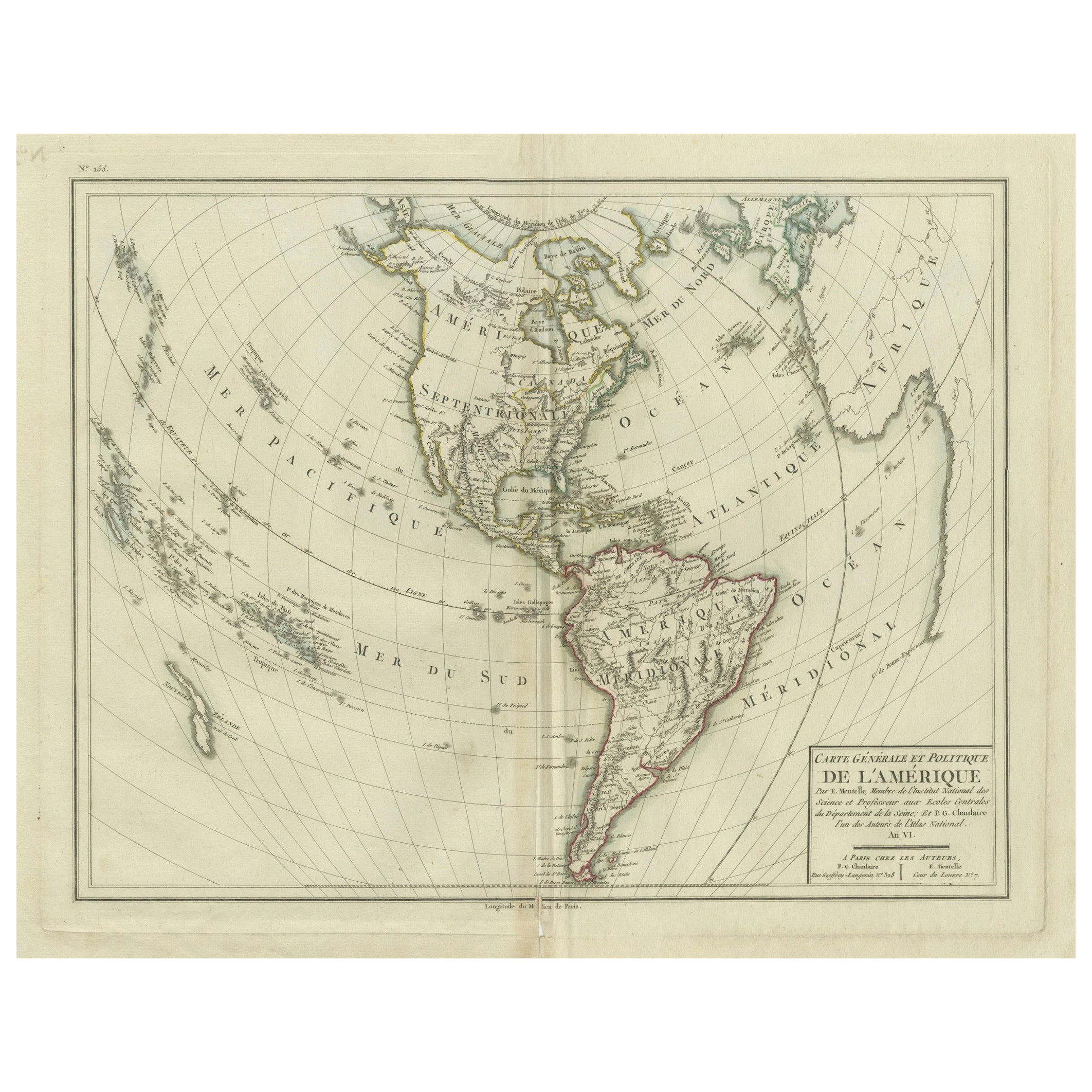
Antique Map of North and South America by Pierre Antoine Tardieu (1784-1869)
Located in Langweer, NL
This is an original antique map titled "Carte Générale et Politique de l'Amérique," depicting the political and geographical features of North and South America. This map, created by Pierre Antoine Tardieu, illustrates the continent's boundaries, major regions, and significant features as understood in the early 19th century.
Map Details:
- **Title**: Carte Générale et Politique de l'Amérique
- **Creator**: Pierre Antoine Tardieu (1784-1869)
- **Publication Date**: Early 19th century
- **Dimensions**: Approximately 34.5 x 43.5 cm (13.5 x 17.25 inches)
- **Features**: The map includes detailed representations of North and South America, highlighting political boundaries, major cities, rivers, and mountain ranges. The title cartouche is located in the lower right corner, and the outlines are hand-colored to distinguish different regions and countries.
Condition Overview:
1. Paper Quality: The paper shows typical signs of aging, such as slight yellowing, but remains in good condition without major tears or damage.
2. Edges and Corners: The edges are slightly worn, with minor fraying and small tears, particularly near the center fold. These imperfections do not significantly impact the overall readability or aesthetic value.
3. Center Fold: A center fold is present, which is common for maps of this period that were often folded for storage or publication. The fold appears intact without significant separation or damage, except for a small split at the lower end.
4. Color and Print Quality: The hand-colored outlines remain vibrant and clear, highlighting the borders of different regions. The print quality is excellent, with sharp, legible text and detailed illustrations.
5. Staining and Spots: There are a few spots and stains, particularly near the edges and along the fold. These do not obscure any critical details of the map.
Historical Context
Around the year 1800, the Americas were a region of significant political change and exploration. Here’s an overview of the region during that period:
Political Landscape
1. North America:
- United States: The United States was a young nation, having gained independence from Great Britain in 1776. The early 19th century was a period of westward expansion and the establishment of new states.
- Canada: Canada was divided into British colonies, including Upper Canada (Ontario) and Lower Canada (Quebec). The British maintained control over these territories following the American Revolution.
- Mexico: Mexico was part of the Spanish Empire, known as New Spain. It would gain independence from Spain in 1821.
2. Central and South America:
- Spanish Colonies: Much of Central and South America was under Spanish colonial rule. Significant regions included New Granada (Colombia), Peru, and the Viceroyalty of the Rio de la Plata (Argentina).
- Portuguese Brazil: Brazil was a Portuguese colony and the largest territory in South America. It would gain independence from Portugal in 1822.
- Independence Movements: The early 19th century was marked by independence movements across Latin America, led by figures such as Simón Bolívar and José de San Martín, which resulted in the creation of new nations.
3. Caribbean:
- The Caribbean islands were controlled by various European powers, including Spain, France, Great Britain, and the Netherlands. These islands were significant for their sugar plantations and as hubs of the Atlantic slave trade.
Socio-Economic Conditions
1. Trade and Commerce:
- The Americas were integral to global trade, exporting commodities such as sugar, tobacco, cotton, and coffee. The port cities of Havana, Veracruz, and Buenos Aires were crucial trade...
Category
Antique Early 1800s Maps
Materials
Paper
$493 Sale Price
20% Off
You May Also Like
Original Antique Map of South America. C.1780
Located in St Annes, Lancashire
Great map of South America
Copper-plate engraving
Published C.1780
Two small worm holes to left side of map
Unframed.
Category
Antique Early 1800s English Georgian Maps
Materials
Paper

Early 19th Century Hand Coloured Map of North America by Aaron Arrowsmith
By Aaron Arrowsmith
Located in Hamilton, Ontario
Hand coloured map in French by English cartographer Aaron Arrowsmith (1750–1823) titled "Amerique Septentionale" (North America).
Map size: 9.5" x 8"
Mat size: 20.5" x 14.25".
Category
Antique Early 19th Century English Maps
Materials
Paper

$795 Sale Price
36% Off
Original Antique Map of The World by Thomas Clerk, 1817
Located in St Annes, Lancashire
Great map of The Eastern and Western Hemispheres
On 2 sheets
Copper-plate engraving
Drawn and engraved by Thomas Clerk, Edinburgh.
Published by Mackenzie And Dent, 1817
...
Category
Antique 1810s English Maps
Materials
Paper

Original Antique Map of The Western Hemisphere by Dower, circa 1835
Located in St Annes, Lancashire
Nice map of the Western Hemisphere
Drawn and engraved by J.Dower
Published by Orr & Smith. C.1835
Unframed.
Free shipping
Category
Antique 1830s English Maps
Materials
Paper

Early 19th Century Hand Colored Map of the United States and Caribbean Islands
Located in Hamilton, Ontario
Hand coloured early 19th century map by Giraldon of France titled "Etats Unis et Grandes Antilles" (United States and Greater Antilles).
Category
Antique Early 19th Century French Maps
Materials
Paper

$595 Sale Price
40% Off
Large Original Vintage Map of North America, circa 1920
Located in St Annes, Lancashire
Great map of North America
Original color. Good condition
Published by Alexander Gross
Unframed.
Category
Vintage 1920s English Edwardian Maps
Materials
Paper

More Ways To Browse
Antique Ivory Collectables
West Indies Furniture
Captain Cook
Antique Maps Of North America
West Indies Antique Furniture
Framed World Map
Hand Drawn Map
18th Century Maps America
Antique Map Of The South Of France
Large Framed Maps
Caribbean Antiques
Caribbean Map
Haitian Wood
North Wind Antique Furniture
Caribbean Colonial Furniture
Antique Maps West Indies
West Indies Colonial
Antique Mississippi Map