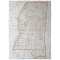

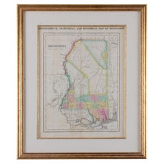
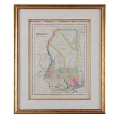
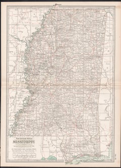
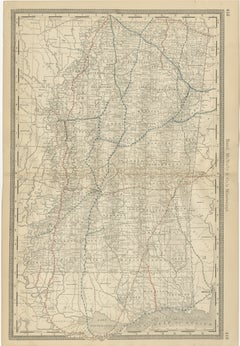
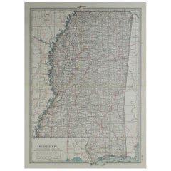
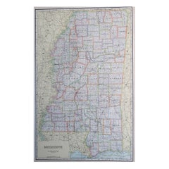
Large Original Antique Map of Mississippi, USA, 1894
By Rand McNally & Co.
Located in St Annes, Lancashire
Fabulous map of Mississippi Original color By Rand, McNally & Co.
Category
1890s American Antique Mississippi Map
Materials
Paper
Large Original Antique Map of Mississippi, USA, 1894
By Rand McNally & Co.
Located in St Annes, Lancashire
Fabulous map of Mississippi Original color By Rand, McNally & Co.
Paper
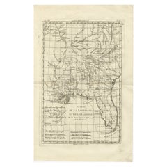
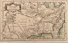
Antique Map Louisiana & Mississippi Valley — Florida Region, Bonne c.1780
Located in Langweer, NL
Antique Map Louisiana & Mississippi Valley — Florida Region, Bonne c.1780 This finely engraved eighteenth-century map of Louisiana and Florida by Rigobert Bonne represents a sig...
Paper

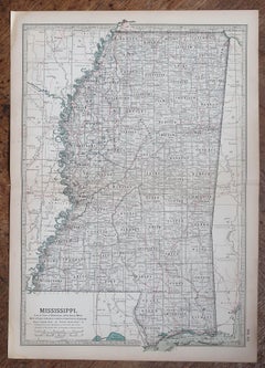
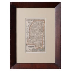
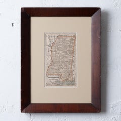
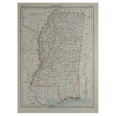
Original Antique Map of the American State of Mississippi, 1903
Located in St Annes, Lancashire
Antique map of Mississippi Published By A & C Black. 1903 Original colour Good condition Unframed.
Paper
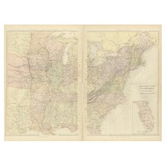
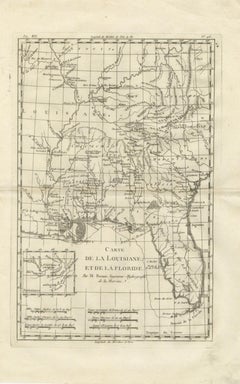
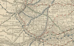
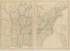
1882 Blackie Atlas Maps: Atlantic States and Mississippi Valley Compilation
Located in Langweer, NL
This area was the industrial and economic heart of the country at the time, with its bustling factories and ports vital to trade and commerce. Map 2: Valley of the Mississippi Thi...
Paper

$232Sale Price|20% Off
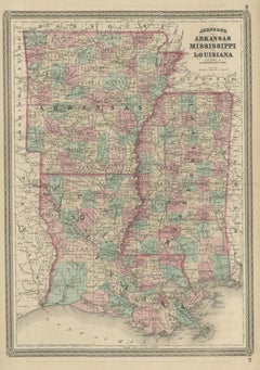
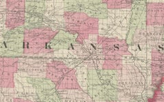
Antique Map of Arkansas, Mississippi and Louisiana by Johnson, 1872
Located in Langweer, NL
Antique map titled 'Johnson's Arkansas (..)'. Original map of Arkansas, Mississippi and Louisiana.
Paper
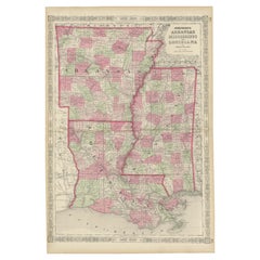
Rare 1864 Civil War Era Map of Arkansas, Mississippi, and Louisiana
Located in Langweer, NL
Title: Rare 1864 Civil War Era Map of Arkansas, Mississippi, and Louisiana Description: This captivating antique map, titled "Johnson's Arkansas, Mississippi, and Louisiana," was pu...
Paper

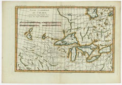
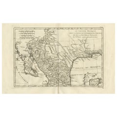
Old Map of the Great Lakes and Upper Mississippi Valley, Northern America, c1780
Located in Langweer, NL
Antique map titled 'Partie Occidentale du Canada'. A fine example of Rigobert Bonne and Guilleme Raynal's 1780 map of the Great Lakes and upper Mississippi Valley.
Paper
1868 "Lloyd's Topographical Railway Map of North America..." Hanging Wall Map
Located in Colorado Springs, CO
Highlights of Lloyd's 20th century vision include a transcontinental railroad, two international telegraph lines, and robust fleets of clipper ships and steamships leaving from New ...
Linen, Paper
$129Sale Price|20% Off
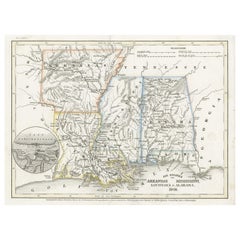
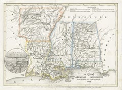
Antique Map of the Southern United States with Inset Map of New Orleans
Located in Langweer, NL
Antique map titled 'Die Staaten von Arkansas Mississippi, Louisiana & Alabama'.
Paper

Antique Minnesota Map Wall Art by Rand McNally, Color Lithograph, 1888
Located in Langweer, NL
Technique: Color lithograph Maker: Rand, McNally & Co., United States, late 19th century Keywords: antique minnesota map, minnesota wall art, rand mcnally map, minneapolis st pa...
Paper
New Mexico & Northern New Spain – Enlightenment Map by Rigobert Bonne, c.1780
Located in Langweer, NL
SEO keywords: New Mexico antique map, Northern New Spain map, Nouvelle Espagne antique map, Nouveau Mexique map, Texas antique map, Louisiana antique map, Spanish colonial map Americ...
Paper
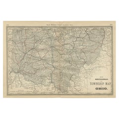
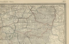
Antique Map of Southern Ohio – The Buckeye State - Railroads & Townships, 1888
Located in Langweer, NL
The Ohio River, forming the southern boundary, is depicted in fine engraved detail, emphasizing its importance as a natural transportation artery linking Ohio to Kentucky, West Virgi...
Paper

$2,175Sale Price|25% Off
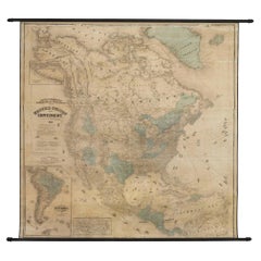
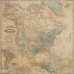
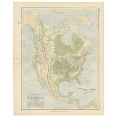
Antique Map of America with California as an Island by Homann '1710'
Located in Langweer, NL
Great Lakes and Mississippi River: The map provides detailed information about the Great Lakes and the course of the Mississippi River.
Paper
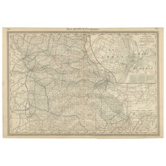
Antique Map of Missouri – The Show-Me State with St. Louis Inset, 1888
Located in Langweer, NL
It captures the state’s counties, towns, and transportation networks, along with a highly detailed inset map of St. Louis and East St. Louis, highlighting the city’s central role as ...
Paper

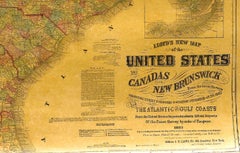
1863 "Lloyd's New Map of the United States, the Canadas, and New Brunswick"
Located in Colorado Springs, CO
The only indication that the American Civil War was in progress when this map was published is a printed notice that Gideon Wells, Secretary of the Navy, wishes to acquire a quote on...
Linen, Wood, Paper
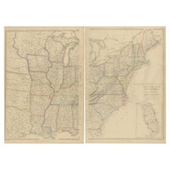
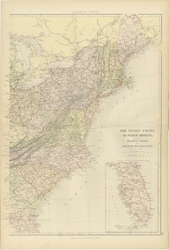
Set of 2 Antique Maps of the United States by W. G. Blackie, 1859
Located in Langweer, NL
Antique map titled 'The United States of North America, Atlantic States and Valley of the Mississippi'.
Paper
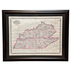
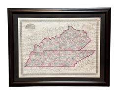
1870 "Johnson's Kentucky and Tennessee" Published by A. J. Johnson
Located in Colorado Springs, CO
Depicted but not colored are the neighboring states of Arkansas, Missouri, Illinois, Indiana, Ohio, West Virginia, Virginia, North Carolina, South Carolina, Georgia, Alabama, and Mis...
Paper
Map of Mississippi Carey & Lea, 1822
Located in Savannah, GA
Published in Philadelphia for the “Complete Historical, Chronological and Geographical American Atlas” by Henry Carey and Issac Lea, the map depicts Mississippi as it existed in 1822.
Glass, Wood, Paper
Map of Mississippi from Fanning's Illustrated Gazetteer, 1853
Located in Savannah, GA
A map of Mississippi from Fanning’s Illustrated Gazetteer, 1853.
Glass, Wood, Paper
Mississippi. USA Century Atlas state antique vintage map
Located in Melbourne, Victoria
'The Century Atlas. Mississippi' Original antique map, 1903. Central fold as issued.
Lithograph
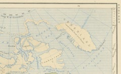
Geological Map of North America by A.K. Johnston – Mountains and Valleys 1852
Located in Langweer, NL
Key geographical features are precisely labeled, including the Rocky Mountains, Appalachian Mountains, Sierra Nevada, Great Basin, Canadian Shield, and Mississippi River Valley. The ...
Paper
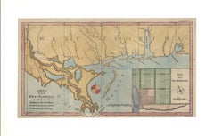
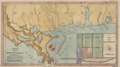
1772 Map of Part of "West Florida"
Located in New York, NY
A fascinating map showing the Mississippi delta and coastal regions of the now states of Mississippi, Alabama and the panhandle of Florida.
Engraving
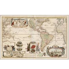
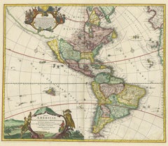
1730 Hand-Colored Antique Map of the Americas
Located in La Jolla, CA
De Leth follows French models and the English American colonies are confined to the Atlantic coast of North America one of the only mentions of Britain as an imperial power on the ma...
Paper
Sold
H 20.67 in W 14.18 in D 0.01 in
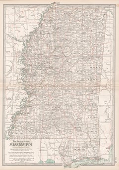
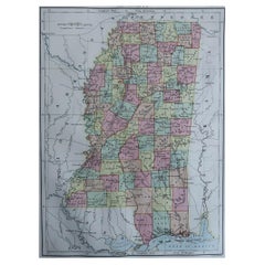
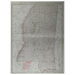
Mississippi Antique Map 1888 – The Magnolia State, Railroads & Counties
Located in Langweer, NL
Mississippi Map 1888 – Rand McNally Antique Lithograph This antique 1888 map of Mississippi, published by Rand, McNally & Co., provides a highly detailed representation of the state...
Paper
Sold
H 86 in W 83 in D 5.25 in
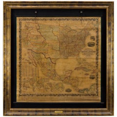
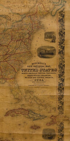
Mitchell's New National Wall Map Exhibiting the United States, circa 1856
Located in Colorado Springs, CO
A seminal map and a must for any serious United States, Southwest or Trans-Mississippi map collection.

Sold
H 21 in W 26.5 in D 0.5 in
Antique 1844 J Calvin Smith JH Colton Midwest United States Survey Map 27"
By J.H. Colton
Located in Dayton, OH
Distance tables on the right side show various lengths of routes between popular destinations via water and land, while a decorative view at the bottom shows Maiden’s Rock on the tra...
Paper

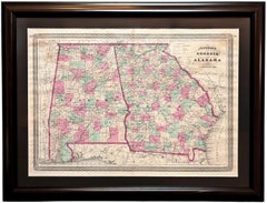
1870 "Johnson's Georgia and Alabama" Published by A. J. Johnson
Located in Colorado Springs, CO
Depicted but not colored are the neighboring states of Tennessee, North Carolina, South Carolina, Florida, and Mississippi. The map is beautifully detailed, with railroads, roads, ri...
Paper
Giltwood Framed and Matted Map
Located in Tarry Town, NY
Giltwood framed and matted library / study room map of Arkansas, Mississippi, Louisiana. Each map is in great condition.
Giltwood, Paper

Original Antique Map of Mississippi, 1889
Located in St Annes, Lancashire
Great map of Mississippi Drawn and Engraved by W. & A.K.
Paper

Original Antique Map of Mississippi, circa 1890
Located in St Annes, Lancashire
Great map of Mississippi Original color. Published, circa 1890 A few minor edge tears Unframed.
Paper

Large Original Antique Map of Mississippi, USA, C.1900
Located in St Annes, Lancashire
Fabulous map of Mississippi Original color Engraved and printed by the George F.
Paper

Original Antique Map of The American State of Mississippi, 1889
Located in St Annes, Lancashire
Great map of Mississippi Drawn and engraved by W. & A.K.
Paper

Sold
H 20.5 in W 27.5 in D 0.07 in
Large Original Antique Map of Mississippi by Rand McNally, circa 1900
By Rand McNally & Co.
Located in St Annes, Lancashire
Fabulous monochrome map with red outline color Original color By Rand, McNally & Co. Published, circa 1900 Unframed Repairs to minor edge tears.
Paper

Sold
H 9.75 in W 6.63 in D 4.38 in
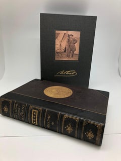
"Personal Memoirs of U.S. Grant" First Edition, Two-Volume Set, circa 1885-1886
By Ulysses S. Grant
Located in Colorado Springs, CO
Front boards feature original gilt stamps celebratory of both U.S. Grant and the Mississippi River. Internally, all maps and fold-outs are present.
Paper
Sold
H 9 in W 14.25 in
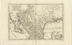
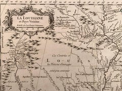
La Louisiane et Pays Voisins (Louisiana and surrounding areas) by Bellin
By Jacques-Nicolas Bellin
Located in New York, NY
Centered on the Mississippi River Valley, this map covers from the Riviere du Nord (Rio Grande) eastward to Lake Ontario and from Lake Huron to the Gulf of Mexico and Florida.
Engraving
It's hard to resist the allure of a beautiful pool. So, go ahead and daydream about whiling away your summer in paradise.
It’s never too early for good design. These interiors combine elevated furnishings and a youthful spirit, resulting in spaces that are at once elegant and whimsical.
Produced in 1843, the well-preserved volume is evidence of the author's exacting specifications.
New or old, the coverlets add old-time charm to any space.
Get into the games! These items celebrate the events, athletes, host countries and sporting spirit.
French trendsetter and serial collector Daniel Rozensztroch tells us about his obsession with objects related to seafaring men.
The sought-after designer worked with the team at Hoffman Creative to produce a monograph that beautifully showcases some of Studio Shamshiri's most inspiring projects.
Italian writer and collector Umberto Pasti opens the doors to his remarkable cave of wonders in North Africa.