Items Similar to Antique Map of Andalusia Spain – Hand-Coloured Tassin Engraving 1651


Want more images or videos?
Request additional images or videos from the seller
1 of 10
Antique Map of Andalusia Spain – Hand-Coloured Tassin Engraving 1651
$512.68
£386.66
€440
CA$708.83
A$794.01
CHF 417.04
MX$9,654.91
NOK 5,281.12
SEK 5,013.21
DKK 3,349.57
About the Item
Antique Map of Andalusia Spain – Hand-Coloured Tassin Engraving 1651
This fine hand-coloured engraved map shows the historic kingdom of Andalusia in southern Spain, created by Nicolas Tassin and published by Nicolas Berey in 1651 in the atlas ‘Cartes Generales des Provinces de France et d’Espagne’. The map is titled ‘Reyno de Andaluzia’ and features a beautifully ornate title cartouche and a delicate coat of arms design in the lower section. Towns, rivers, and regional borders are meticulously engraved, including Sevilla, Malaga, Ronda, Cadiz, and Gibraltar, alongside parts of Portugal such as Algarve and Olivenca.
Nicolas Tassin was an esteemed 17th-century French cartographer known for his precisely engraved provincial maps, valued for their decorative yet informative character. The technique used here is copperplate engraving, printed on hand-laid paper and enhanced with rich contemporary hand colouring. This method ensured extremely fine line work and durability over centuries. The colours used highlight regional divisions and enhance its visual appeal, making it not only a historical document but also a decorative art piece.
Collectors and interior designers favour Tassin’s maps for their historical accuracy combined with attractive baroque-style ornamentation. They provide an authentic glimpse into 17th-century geographical knowledge and territorial boundaries, ideal for classic study rooms, libraries, or elegant living spaces.
Condition summary: The map is in very good condition for its age, with strong impressions and vibrant original hand colouring. Minor age toning is visible in the margins with some faint scattered spotting, but the image itself remains clean and crisp. Edges are slightly browned, typical of antique maps, with no tears or major flaws.
Framing tips: For best presentation, use a dark wood or gilt frame with a neutral cream or lightly textured off-white mount board to emphasise the vivid colours without distraction. Museum-grade UV-protective glass is recommended to preserve the pigments and paper quality over time.
This is a rare opportunity to acquire an authentic 17th-century map by Nicolas Tassin, an elegant addition to any serious map collection or classic European-themed interior.
- Dimensions:Height: 5.91 in (15 cm)Width: 7.72 in (19.6 cm)Depth: 0.01 in (0.2 mm)
- Materials and Techniques:
- Place of Origin:
- Period:Mid-17th Century
- Date of Manufacture:1651
- Condition:Condition summary: Very good condition for its age, with strong impressions and vibrant original hand colouring. Minor age toning is visible in the margins with some faint scattered spotting, but the image itself remains clean and crisp.
- Seller Location:Langweer, NL
- Reference Number:Seller: Bg-14106-11stDibs: LU3054345767552
About the Seller
5.0
Recognized Seller
These prestigious sellers are industry leaders and represent the highest echelon for item quality and design.
Platinum Seller
Premium sellers with a 4.7+ rating and 24-hour response times
Established in 2009
1stDibs seller since 2017
2,517 sales on 1stDibs
Typical response time: <1 hour
- ShippingRetrieving quote...Shipping from: Langweer, Netherlands
- Return Policy
Authenticity Guarantee
In the unlikely event there’s an issue with an item’s authenticity, contact us within 1 year for a full refund. DetailsMoney-Back Guarantee
If your item is not as described, is damaged in transit, or does not arrive, contact us within 7 days for a full refund. Details24-Hour Cancellation
You have a 24-hour grace period in which to reconsider your purchase, with no questions asked.Vetted Professional Sellers
Our world-class sellers must adhere to strict standards for service and quality, maintaining the integrity of our listings.Price-Match Guarantee
If you find that a seller listed the same item for a lower price elsewhere, we’ll match it.Trusted Global Delivery
Our best-in-class carrier network provides specialized shipping options worldwide, including custom delivery.More From This Seller
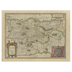
View AllAntique Map of Granada Spain – Hand-Coloured Tassin Engraving 1651
Located in Langweer, NL
Antique Map of Granada Spain – Hand-Coloured Tassin Engraving 1651
This beautiful hand-coloured engraved map depicts the historic Kingdom of Granada in southern Spain, created by th...
Category
Antique Mid-17th Century French Maps
Materials
Paper
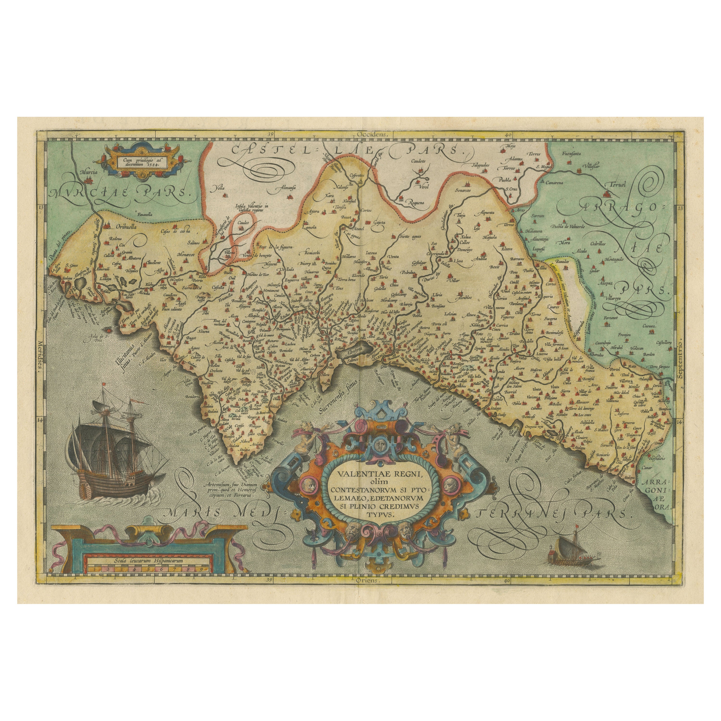
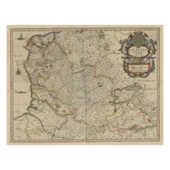
Decorative Original Antique Map of Valencia in Southern Spain, circa 1601
Located in Langweer, NL
This is an original antique map titled 'Valentiae Regni olim Contestanorum Si Ptolemaeo, Edentanorum Si Plinio Credimus Typus'. This is a historical map of the Kingdom of Valencia in...
Category
Antique Early 17th Century Maps
Materials
Paper

$1,305 Sale Price
20% Off
Free Shipping
Antique Map of Northeastern Spain by Mercator, 1634
Located in Langweer, NL
Antique map titled 'Biscaia, Guipiscoa, Navarra et Asturias de Santillana'. Charming map of Northeastern Spain with the areas of Pamplona and Valladolid. This map originates from 'At...
Category
Antique 17th Century Maps
Materials
Paper
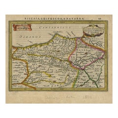
$129 Sale Price
20% Off
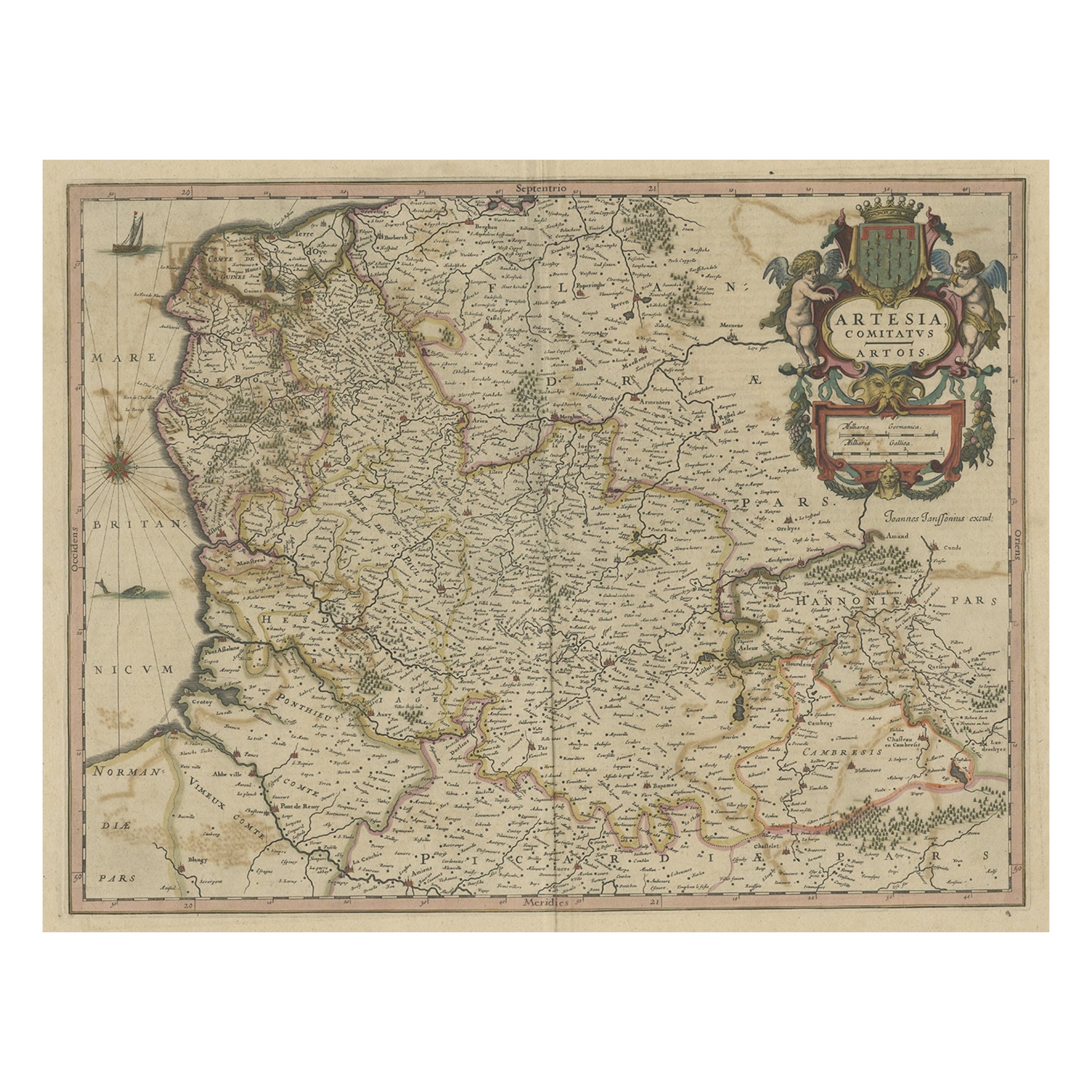
Original Hand-Colored Antique Map of Artois or Artesia, France, ca.1650
Located in Langweer, NL
Antique map titled 'Artesia Comitatus Artois'.
Map of Artois or Artesia, France. Artois is former province located in the northwestern part of France, boarding Belgium (Flanders)...
Category
Antique 1650s Maps
Materials
Paper
$316 Sale Price
20% Off
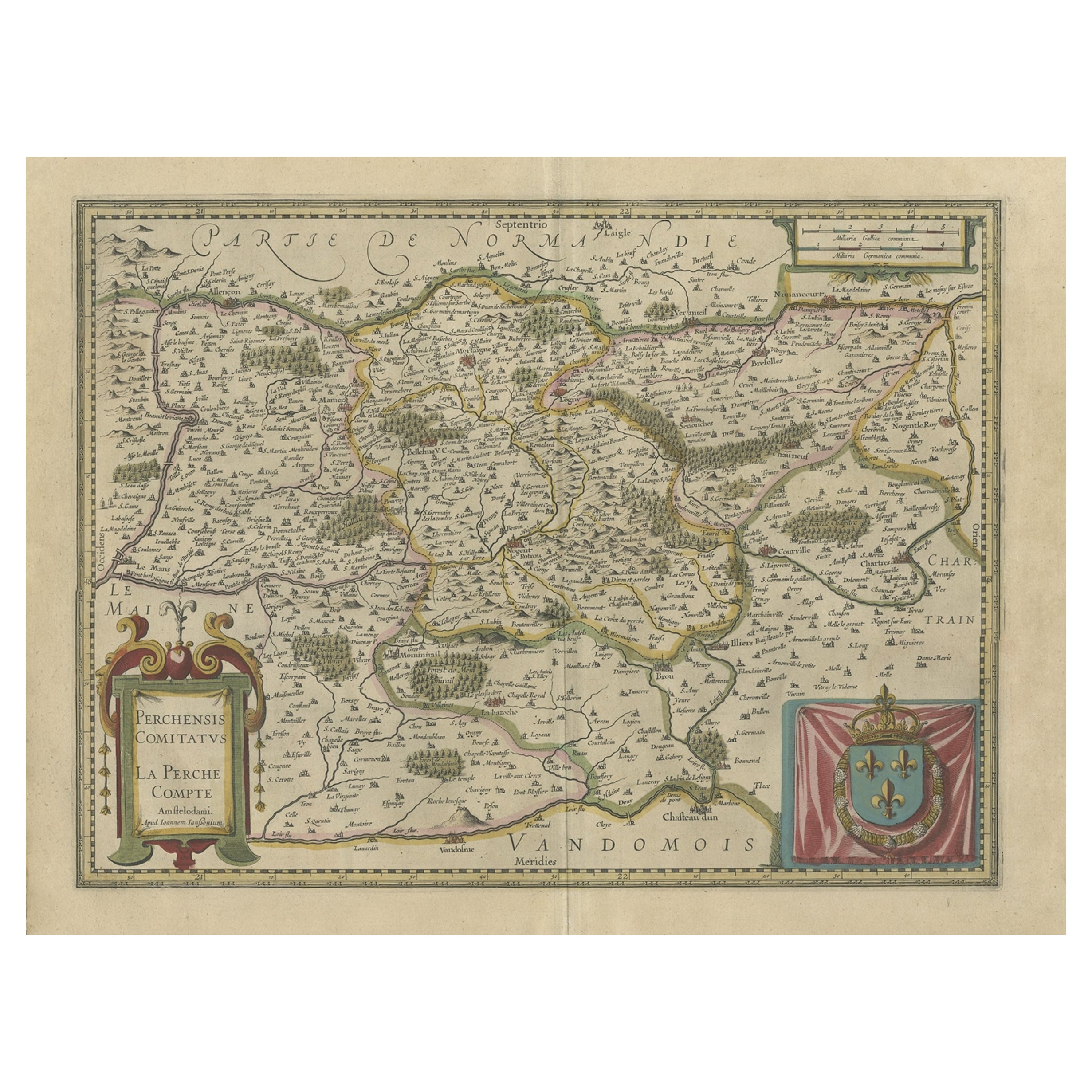
Old Original Handcoloured Map of the Former Province of Perche, France, ca.1640
Located in Langweer, NL
Antique map titled 'Perchensis Comitatus - La Perche compte'.
Old map of the former province of Perche, France. Until the French Revolution, Perche was bounded by four ancient te...
Category
Antique 1640s Maps
Materials
Paper
$671 Sale Price
20% Off
Antique Map of Spain by N. de Fer, circa 1700
Located in Langweer, NL
Antique map of Spain and Portugal with a title cartouche. Nicolas de Fer was the youngest son of the Paris printer and publisher Antoine de Fer. At the ...
Category
Antique Early 18th Century Maps
Materials
Paper
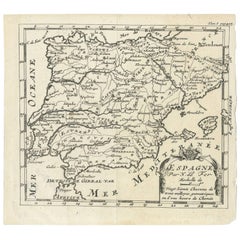
$149 Sale Price
20% Off
You May Also Like
18th Century Hand Colored Map of Spain and Portugal by Visscher
By Nicolaes Visscher II
Located in Alamo, CA
This is an early 18th century map of Spain and Portugal, with attractive original hand-coloring, entitled "Hispaniae et Portugalliae Regna per Nicolaum Visscher cum Privilegio Ordinu...
Category
Antique Early 18th Century Dutch Maps
Materials
Paper

Spain and Portugal: A Hand-colored 17th/18th Century Map by Visscher
By Nicolaus Visscher
Located in Alamo, CA
This is an early 18th century map of Spain and Portugal, with attractive original hand-coloring, entitled "Hispaniae et Portugalliae Regna per Nicolaum Visscher cum Privilegio Ordinum Hollandiae et Westfrisiae" first published by Nicolaes Visscher II (1649-1702) in 1688, and later re-published from Visscher's original copper plate by Peter Schenk, Junior in Amsterdam in 1725. The cartouche in the right lower corner depicts a coat of arms representing one combined kingdom of Spain and Portugal before their break-up. Putti hold up the coat-of-arms of Phillip II on the right and a queen reaches for it on the left. There is a scale cartouche in the lower left corner surmounted by two putti and a wheel. This is an outstanding depiction of the Iberian peninsula, showing Spain and Portugal and Balearic Islands. The map includes portions of North Africa and the Strait of Gibralter.
This copperplate engraved map is presented in a cream-colored mat. It is printed on fine chain-linked, laid paper. The mat measures 26.5" high by 30" wide and the sheet measures 21.75" high by 26.375" wide. There is a central fold, as issued. The lower portion of the fold is reinforced on the verso. There is a small paper defect at the lower edge of the fold and another at the edge of the right corner, as well as a few small tears along the lower edge; none affecting the map and all covered by the mat. There are a few small faint spots in the upper margin and on the left. The map is otherwise in very good condition.
The Visscher family were one of the great art and cartographic printing families of the 17th century. Begun by Claes Jansz Visscher...
Category
Late 17th Century Other Art Style Landscape Prints
Materials
Engraving

"Nova Barbariae Descriptio", a 17th Century Hand-Colored Map of North Africa
By Johannes Janssonius
Located in Alamo, CA
This original attractive 17th century hand-colored map of North Africa entitled "Nova Barbariae Descriptio" by Johannes Janssonius was published in Paris in 1635. It includes the Med...
Category
Antique Mid-17th Century Dutch Maps
Materials
Paper

Prussia, Poland, N. Germany, Etc: A Hand-colored 17th Century Map by Janssonius
By Johannes Janssonius
Located in Alamo, CA
This is an attractive hand-colored copperplate engraved 17th century map of Prussia entitled "Prussia Accurate Descripta a Gasparo Henneberg Erlichensi", published in Amsterdam by Joannes Janssonius in 1664. This very detailed map from the golden age of Dutch cartography includes present-day Poland, Latvia, Lithuania, Estonia and portions of Germany. This highly detailed map is embellished by three ornate pink, red, mint green and gold...
Category
Antique Mid-17th Century Dutch Maps
Materials
Paper

17th Century Hand-Colored Map of a Region in West Germany by Janssonius
By Johannes Janssonius
Located in Alamo, CA
This attractive highly detailed 17th century original hand-colored map is entitled "Archiepiscopatus Maghdeburgensis et Anhaltinus Ducatus cum terris adjacentibus". It was published ...
Category
Antique Mid-17th Century Dutch Maps
Materials
Paper

Original Antique Map of Spain and Portugal, circa 1790
Located in St Annes, Lancashire
Super map of Spain and Portugal
Copper plate engraving by A. Bell
Published, circa 1790.
Unframed.
Category
Antique 1790s English Other Maps
Materials
Paper

More Ways To Browse
Spanish Library
Classic Engraving
Coat Of Arms Engraving
Spanish Provincial
Antique Hand Carts
Antique Hand Trolley
Gilt Coat Of Arms
Spanish Frame 17th Century
Spanish Andalusia
Wood Minimalist Chair
Antique Imperial Furniture
Gold Modern Coffee Table
Large Side Tables
18th Century Gilded Furniture
Japanese Silver Ceramics
One Of A Kind Chair
Used Oak Dining Room Chairs
17th Century Plate