Items Similar to Antique Map of Asian Turkey, Levant, and Mesopotamia by Tardieu, circa 1802


Want more images or videos?
Request additional images or videos from the seller
1 of 7
Antique Map of Asian Turkey, Levant, and Mesopotamia by Tardieu, circa 1802
$421.75
$527.1820% Off
£313.90
£392.3820% Off
€352
€44020% Off
CA$577.69
CA$722.1120% Off
A$642.51
A$803.1420% Off
CHF 335.50
CHF 419.3820% Off
MX$7,818.72
MX$9,773.4020% Off
NOK 4,284.86
NOK 5,356.0820% Off
SEK 4,018.44
SEK 5,023.0520% Off
DKK 2,679.65
DKK 3,349.5720% Off
Shipping
Retrieving quote...The 1stDibs Promise:
Authenticity Guarantee,
Money-Back Guarantee,
24-Hour Cancellation
About the Item
This is an original antique map titled "Carte de la Turquie Asiatique," depicting the Asian territories of the Ottoman Empire. Created by Pierre Antoine Tardieu, this map illustrates the vast expanse of the Ottoman Empire in Asia, including modern-day Turkey, the Levant, parts of the Arabian Peninsula, and adjacent regions.
Map Details:
- **Title**: Carte de la Turquie Asiatique
- **Creator**: Pierre Antoine Tardieu (1784-1869)
- **Publication Date**: Early 19th century
- **Dimensions**: Approximately 34.5 x 43.5 cm (13.5 x 17.25 inches)
- **Features**: The map provides a detailed depiction of the Ottoman territories in Asia, highlighting various regions, cities, rivers, and mountain ranges. The title cartouche is located in the upper left corner, and the outlines are hand-colored to distinguish different areas. Bahrein is also mentioned.
Condition Overview:
1. **Paper Quality**: The paper shows typical signs of aging, such as slight yellowing, but remains in good condition without major tears or damage.
2. **Edges and Corners**: The edges are slightly worn, with minor fraying and small tears, particularly near the center fold. These imperfections do not significantly impact the overall readability or aesthetic value.
3. **Center Fold**: A center fold is present, which is common for maps of this period that were often folded for storage or publication. The fold appears intact but without separation at both ends.
4. **Color and Print Quality**: The hand-colored outlines remain vibrant and clear, highlighting the borders of different regions. The print quality is excellent, with sharp, legible text and detailed illustrations.
5. **Staining and Spots**: There are a few spots and stains, particularly near the edges and along the fold. These do not obscure any critical details of the map.
Historical Context
Around 1800, the Asian territories of the Ottoman Empire were diverse and strategically important. Here’s an overview of the region during that period:
Political Landscape
1. **Ottoman Administration**:
- The Ottoman Empire governed its Asian territories through a system of provinces (vilayets) and smaller administrative units (sanjaks). These regions included Anatolia (modern-day Turkey), the Levant (Syria, Lebanon, Israel, Jordan), Mesopotamia (Iraq), and parts of the Arabian Peninsula.
- Key cities like Constantinople (Istanbul), Baghdad, Damascus, and Aleppo were significant centers of administration, trade, and culture.
2. **Neighboring Powers**:
- The Persian Empire (Qajar Dynasty) to the east was a significant neighbor and occasional rival.
- The Russian Empire was also expanding southward into the Caucasus, posing a threat to Ottoman territories.
Socio-Economic Conditions
1. **Trade and Commerce**:
- The region was a crucial link in trade routes connecting Europe with Asia. The cities of the Levant and Mesopotamia were bustling centers of commerce, facilitating trade in goods like spices, textiles, and precious metals.
- The port cities along the Mediterranean and the Red Sea played vital roles in international trade networks.
2. **Agriculture and Resources**:
- Agriculture was a primary economic activity, with fertile lands in Mesopotamia and the Levant supporting diverse crops. The Arabian Peninsula, though largely desert, was significant for its trade routes and resources like incense and spices.
3. **Cultural and Religious Diversity**:
- The region was home to a mosaic of cultures and religions, including Muslims (Sunni and Shia), Christians (various denominations), Jews, and other smaller religious communities.
- This diversity was reflected in the cultural, architectural, and intellectual life of the region.
Conflicts and Changes
1. **Internal Struggles**:
- The Ottoman Empire faced internal challenges, including administrative inefficiency, corruption, and local uprisings. Efforts to modernize the military and bureaucracy were ongoing but met with mixed success.
2. **Napoleonic Wars**:
- The Napoleonic Wars (1799-1815) had indirect effects on the region, with shifting alliances and the involvement of European powers impacting the geopolitical landscape.
3. **Regional Revolts**:
- Local revolts and uprisings, often driven by nationalist or sectarian sentiments, were common. These were sometimes suppressed by the central Ottoman authority, but they also indicated the underlying tensions within the empire.
Summary
The Asian territories of the Ottoman Empire around 1800 were a vital part of a vast and diverse empire, characterized by significant economic activity, cultural richness, and strategic importance. The region was a crossroads of civilizations, influenced by internal dynamics and external pressures that would shape its history in the 19th century and beyond.
- Dimensions:Height: 16.42 in (41.7 cm)Width: 22.05 in (56 cm)Depth: 0.01 in (0.2 mm)
- Materials and Techniques:Paper,Engraved
- Period:
- Date of Manufacture:1802
- Condition:Good condition with minor age-related wear. Hand-colored boundaries are well-preserved, enhancing the clarity of regions and features. Fold lines with split at ends . Edge wear due to handling and age visible. Study the images carefully.
- Seller Location:Langweer, NL
- Reference Number:Seller: BG-13769-301stDibs: LU3054340565372
About the Seller
5.0
Recognized Seller
These prestigious sellers are industry leaders and represent the highest echelon for item quality and design.
Platinum Seller
Premium sellers with a 4.7+ rating and 24-hour response times
Established in 2009
1stDibs seller since 2017
2,508 sales on 1stDibs
Typical response time: <1 hour
- ShippingRetrieving quote...Shipping from: Langweer, Netherlands
- Return Policy
Authenticity Guarantee
In the unlikely event there’s an issue with an item’s authenticity, contact us within 1 year for a full refund. DetailsMoney-Back Guarantee
If your item is not as described, is damaged in transit, or does not arrive, contact us within 7 days for a full refund. Details24-Hour Cancellation
You have a 24-hour grace period in which to reconsider your purchase, with no questions asked.Vetted Professional Sellers
Our world-class sellers must adhere to strict standards for service and quality, maintaining the integrity of our listings.Price-Match Guarantee
If you find that a seller listed the same item for a lower price elsewhere, we’ll match it.Trusted Global Delivery
Our best-in-class carrier network provides specialized shipping options worldwide, including custom delivery.More From This Seller
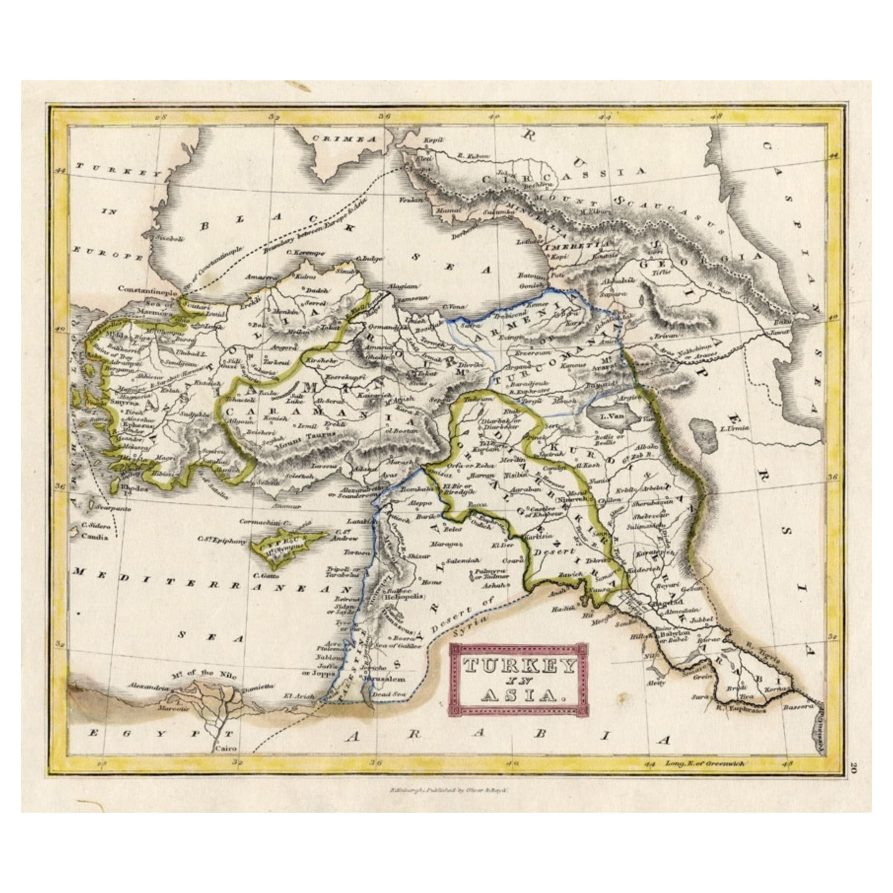
View AllAntique Map of Turkey in Asia 'Asia Minor', 1841
Located in Langweer, NL
Antique map titled 'Turkey in Asia'. Original antique map of Asia Minor (Turkey). Source unknown, to be determined.
Artists and Engravers: Published by O...
Category
Antique 19th Century Maps
Materials
Paper

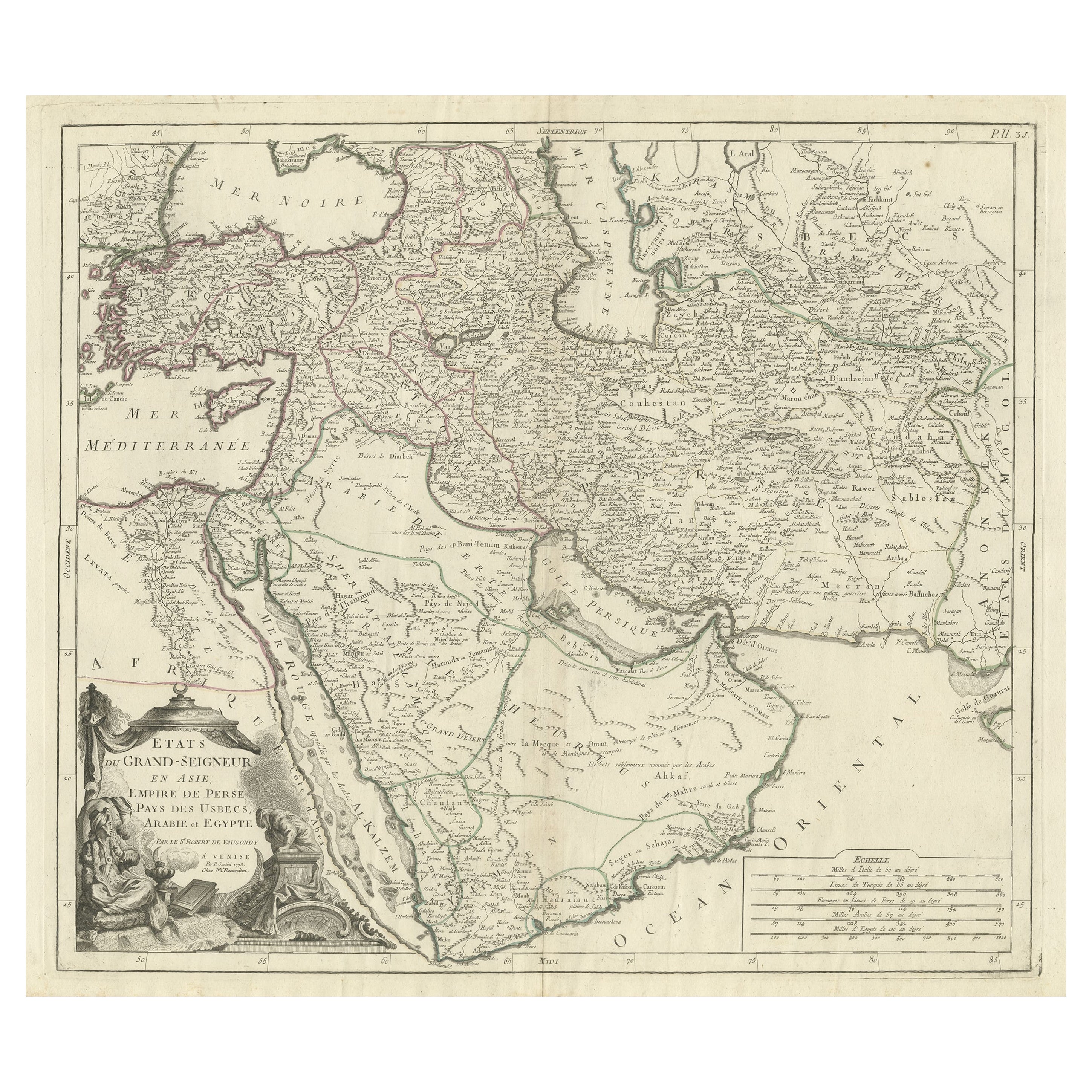
Detailed Original Antique Map of the Turkish Empire with Arabia, 1778
Located in Langweer, NL
Title: Etats Due Grand-Seigneur En Asie, Empire De Perse, Pays Des Usbecs, Arabie et Egypte . . . 1753
Detailed map of the Turkish Empire, extending to the Black Sea, Georgia, the...
Category
Antique 1770s Maps
Materials
Paper

$460 Sale Price
20% Off
Antique Map of the Turkish Empire by Tirion 'c.1760'
Located in Langweer, NL
Antique map titled 'Nieuwe Kaart van het Turksche Ryk gelegen in Europa, Asia en Africa'. Original antique map of the Turkish Empire. The map is centered on the Mediterranean Sea but...
Category
Antique Mid-18th Century Maps
Materials
Paper

$1,341 Sale Price
20% Off
Antique Map of the Middle East by Brion de la Tour '1772'
Located in Langweer, NL
Antique map titled 'Carte des Pays et Principaux Lieux (..)'. Original antique map of Middle East, extending to the Red Sea, Egypt, the Eastern Medi...
Category
Antique Late 18th Century Maps
Materials
Paper
$623 Sale Price
20% Off
Antique Map of Western Asia by Van Dùren '1752'
Located in Langweer, NL
Antique map titled 'Neue Geographische Vorstellung von Asien'. Original antique map of Western Asia. This map originates from 'Neue Sammlung der merkwürdigsten Reisegeschichten, inso...
Category
Antique Mid-18th Century Maps
Materials
Paper

$431 Sale Price
20% Off
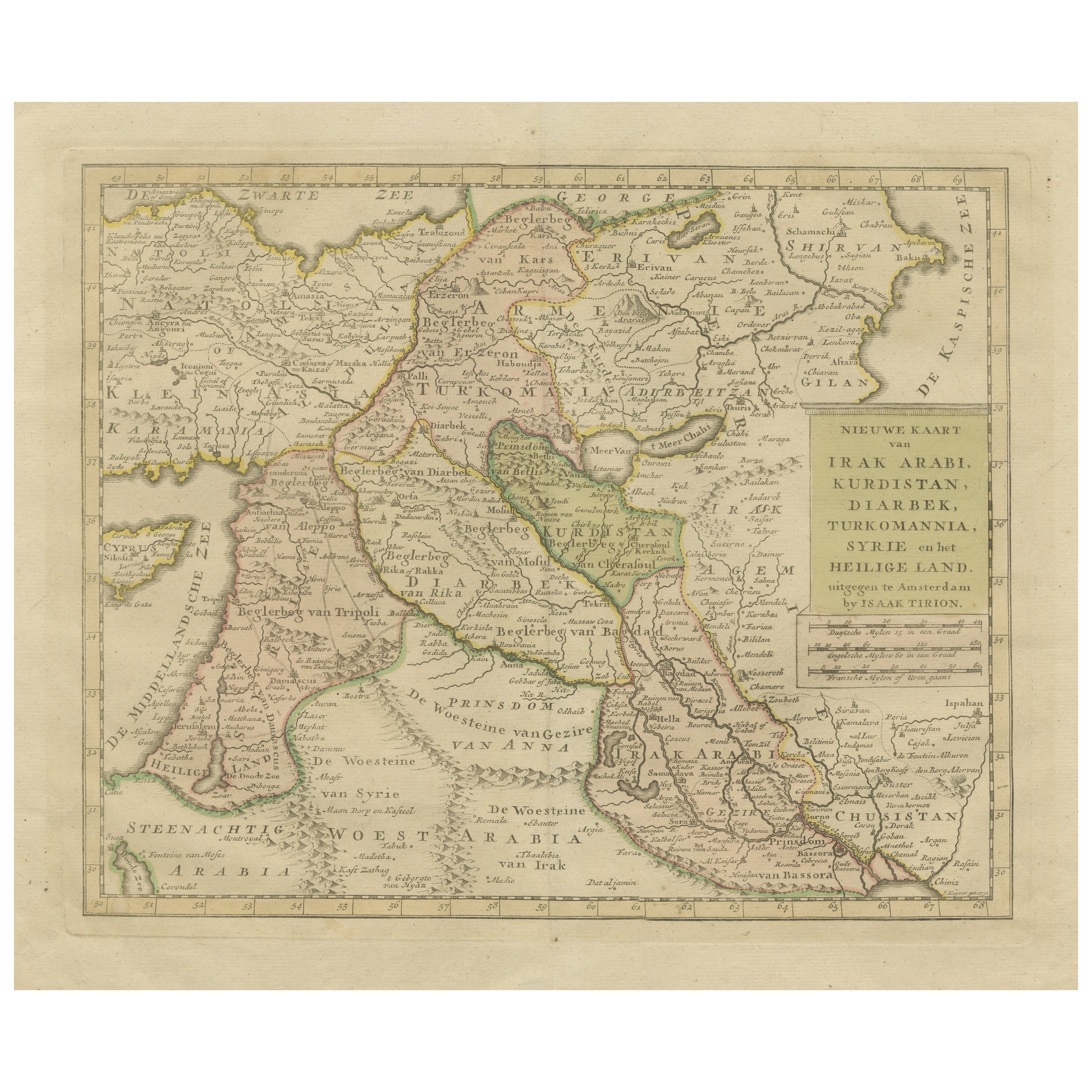
Antique Map of Eastern Turkey, Caucasus, Israel through Iraq and part of Arabia
Located in Langweer, NL
Antique map titled 'Nieuwe Kaart van Irak Arabia, Kurdistan, Diarbek, Turkomannia, Syrie en het Heilige Land'. Beautiful map including eastern Turkey, the Caucasus, Israel through Ir...
Category
Antique Mid-18th Century Maps
Materials
Paper

$440 Sale Price
20% Off
You May Also Like
Original Antique Map of Ancient Greece, Achaia, Corinth, 1786
Located in St Annes, Lancashire
Great map of Ancient Greece. Showing the region of Thessaly, including Mount Olympus
Drawn by J.D. Barbie Du Bocage
Copper plate engraving by P.F Tardieu
Original hand color...
Category
Antique 1780s French Other Maps
Materials
Paper

Circa 1825 original engraving of the map of Syria by Giraldon Bovinet
Located in PARIS, FR
The circa 1825 original engraving of "Syrie" by Giraldon Bovinet, based on the work of L. Vivien, is a historically significant map that reflects early 19th-century cartographic tech...
Category
1820s Prints and Multiples
Materials
Engraving, Paper

Hand-Colored 18th Century Homann Map of the Black Sea, Turkey and Asia Minor
By Johann Baptist Homann
Located in Alamo, CA
An attractive original early 18th century hand-colored map of the Black Sea and Turkey entitled "Carte de L'Asie Minevre ou de la Natolie et du Pont Evxin Tiree des Voyages et des Ob...
Category
Antique Early 18th Century German Maps
Materials
Paper

Persia, Armenia & Adjacent Regions: A Hand-colored 17th Century Map by De Wit
By Frederick de Wit
Located in Alamo, CA
This colorful and detailed 17th century copperplate map by Frederick De Wit was published in Amsterdam between 1666 and 1690. It depicts the Caspian Se...
Category
Late 17th Century Old Masters More Prints
Materials
Engraving

Persia, Armenia & Adjacent Regions: A 17th Century Hand-colored Map by De Wit
By Frederick de Wit
Located in Alamo, CA
A large 17th century hand colored copperplate engraved map entitled "Novissima nec non Perfectissima Scandinaviae Tabula comprehendens Regnorum Sueciae, Daniae et Norvegiae distincte...
Category
Antique Late 17th Century Dutch Maps
Materials
Paper

Antique French Map of Asia Including China Indoneseia India, 1783
Located in Amsterdam, Noord Holland
Very nice map of Asia. 1783 Dedie au Roy.
Additional information:
Country of Manufacturing: Europe
Period: 18th century Qing (1661 - 1912)
Condition: Overall Condition B (Good Used)...
Category
Antique 18th Century European Maps
Materials
Paper

$648 Sale Price
20% Off
More Ways To Browse
Antique Ottoman Empire
Istanbul Antique
Map Storage
Damascus Furniture
Modern Storage Ottoman
Syrian Ottoman Furniture
Antique Damascus
Lebanese Antiques
Antique Furniture Lebanon
Antique Map Storage
Antique Ottoman With Storage
Religious Mosaic
Syrian Mosaic
Arabian Syrian
Qajar Engraved
Silver Over Copper
Vintage Barware Glasses
Coffee Table Black Italian Modern