Items Similar to Detailed Original Antique Map of the Turkish Empire with Arabia, 1778


Want more images or videos?
Request additional images or videos from the seller
1 of 6
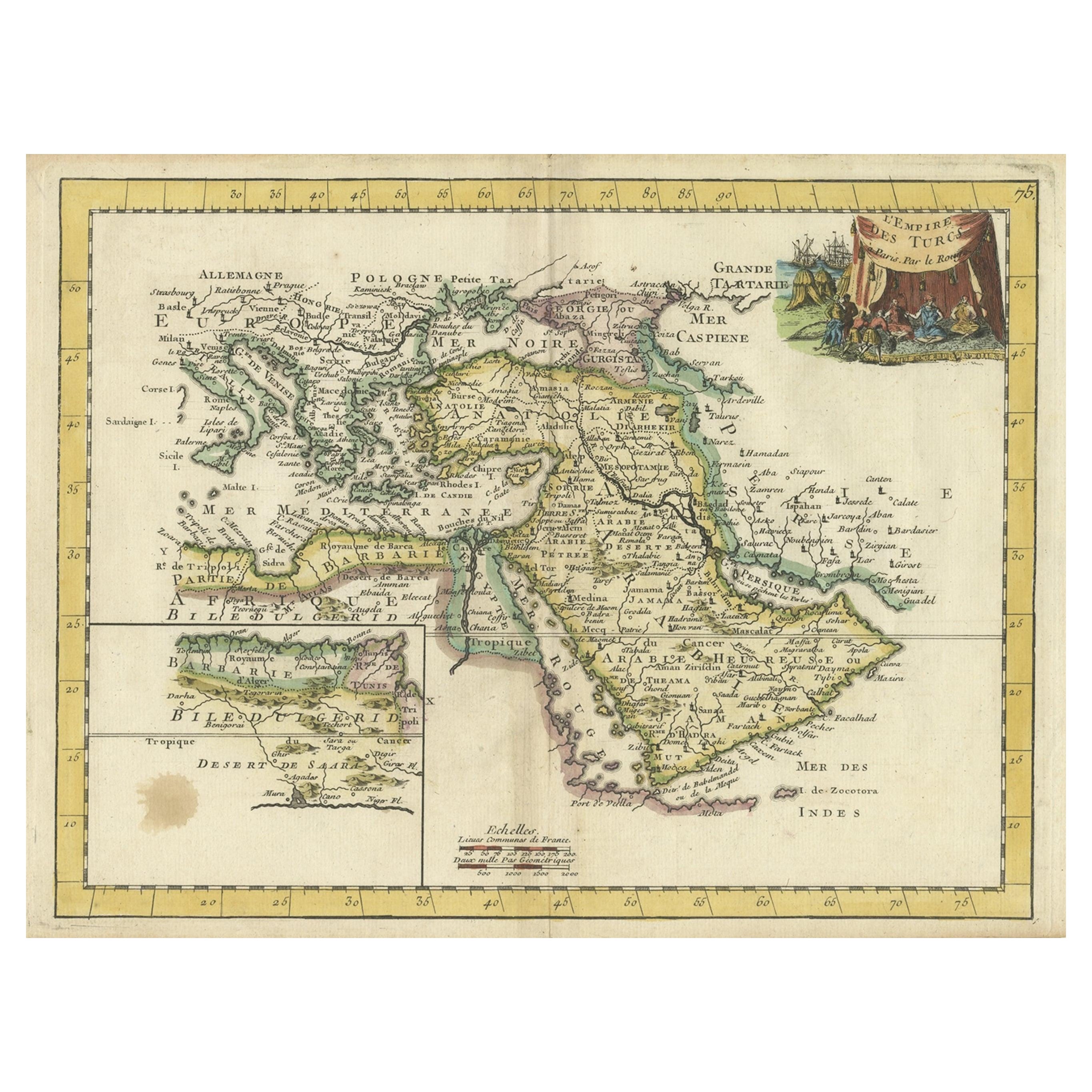
Detailed Original Antique Map of the Turkish Empire with Arabia, 1778
About the Item
Title: Etats Due Grand-Seigneur En Asie, Empire De Perse, Pays Des Usbecs, Arabie et Egypte . . . 1753
Detailed map of the Turkish Empire, extending to the Black Sea, Georgia, the Caspian, Usbekistan, The Indian Ocean, Saudi Arabia, Egypt and the Red Sea.
Large decorative cartouche.
Didier Robert de Vaugondy (ca. 1723-1786) was the son of prominent geographer Gilles Robert de Vaugondy and Didier carried on his father’s impressive work. Together, they published their best-known work, the Atlas Universel (1757). The atlas took fifteen years to create and was released in a folio and ¾ folio edition; both are rare and highly sought-after today. Together and individually, father and son were known for their exactitude and depth of research.
Like his father, Didier served as geographer to King Louis XV. He was especially recognized for his skills in globe making; for example, a pair of his globes made for the Marquise de Pompadour are today in the collection of the Municipal Museum of Chartres. Didier was also the geographer to the Duke of Lorraine. In 1773, he was appointed royal censor in charge of monitoring the information published in geography texts, navigational tracts, and travel accounts.
- Dimensions:Height: 20.87 in (53 cm)Width: 29.53 in (75 cm)Depth: 0 in (0.02 mm)
- Materials and Techniques:Paper,Engraved
- Period:1770-1779
- Date of Manufacture:1778
- Condition:Wear consistent with age and use. Vertical fold in the middle as issued and a few creases or wrinkles overall. Some browning but mainly in the margins well outside the image. Borders handcolored. Wide margins. Strong paper.
- Seller Location:Langweer, NL
- Reference Number:
About the Seller
5.0
Platinum Seller
These expertly vetted sellers are 1stDibs' most experienced sellers and are rated highest by our customers.
Established in 2009
1stDibs seller since 2017
1,932 sales on 1stDibs
Typical response time: <1 hour
- ShippingRetrieving quote...Ships From: Langweer, Netherlands
- Return PolicyA return for this item may be initiated within 14 days of delivery.
More From This SellerView All
- Original Antique Engraved Map of the Russian Empire, 1778Located in Langweer, NLDescription: Antique map titled 'A New and Correct Map of the Russian Empire'. Original antique map of the Russian Empire. This map originates from Moore's 'New and Complete Coll...Category
Antique 1770s Maps
MaterialsPaper
- Detailed Original Antique Map of the Russian Empire in Asia, 1750Located in Langweer, NLAntique map titled 'Partie Orientale de l'Empire de Russie en Asie (..)'. Detailed map of the Russian Empire in Asia. Artists and Engravers: Gilles Robert de Vaugondy (1688-1766) was the head of a leading family of geographers in eighteenth century France. Gilles got his start when he jointly inherited the shop of Pierre-Moullart Sanson, grandson of the famous geographer Nicholas Sanson. The inheritance included the business, its stock of plates, and a roller press...Category
Antique 1750s Maps
MaterialsPaper
- Original Antique Map of Arabia and the Red SeaLocated in Langweer, NLAntique map titled 'Carte de la Coste d'Arabie (..) - Kaart van de Kust van Arabië (..)'. This is a Dutch version, engraved by J. van Schley, of Bellin's map of Arabia and the Red Se...Category
Antique Mid-18th Century Maps
MaterialsPaper
- Antique Map of the Turkish Empire by Tirion 'c.1760'Located in Langweer, NLAntique map titled 'Nieuwe Kaart van het Turksche Ryk gelegen in Europa, Asia en Africa'. Original antique map of the Turkish Empire. The map is centered on the Mediterranean Sea but...Category
Antique Mid-18th Century Maps
MaterialsPaper
- Orginal Antique Handcolored Map of the Turkish Empire, 1748Located in Langweer, NLAntique map titled 'L'Empire des Turcs'. Old map of the Turkish Empire with an inset of the North African regions. Originates from 'Atlas Nouveau Portatif' by G.L. le Rouge. Artis...Category
Antique 18th Century Maps
MaterialsPaper
- Original Detailed Antique Map of the East Coast of Africa, 1747Located in Langweer, NLAntique map titled 'Carte de la coste Orientale d'Afrique - Kaart van de Oostkust van Afrika'. Original antique map of the east coast of Africa. Reaches from Cape of Good Hope an...Category
Antique 1740s Maps
MaterialsPaper


You May Also Like
- Original Antique Map of Italy. C.1780Located in St Annes, LancashireGreat map of Italy Copper-plate engraving Published C.1780 Unframed.Category
Antique Early 1800s English Georgian Maps
MaterialsPaper

- Original Antique Map of Asia. C.1780Located in St Annes, LancashireGreat map of Asia Copper-plate engraving Published C.1780 Two small worm holes to right side of map Unframed.Category
Antique Early 1800s English Georgian Maps
MaterialsPaper

- Original Antique Map of India. C.1780Located in St Annes, LancashireGreat map of India Copper-plate engraving Published C.1780 Three small worm holes to right side of map and one bottom left corner Unframed.Category
Antique Early 1800s English Georgian Maps
MaterialsPaper

- Original Antique Map of The World by Thomas Clerk, 1817Located in St Annes, LancashireGreat map of The Eastern and Western Hemispheres On 2 sheets Copper-plate engraving Drawn and engraved by Thomas Clerk, Edinburgh. Published by Mackenzie And Dent, 1817 ...Category
Antique 1810s English Maps
MaterialsPaper
- Original Antique Map of The Netherlands, Sherwood, Neely & Jones, Dated 1809Located in St Annes, LancashireGreat map of The Netherlands Copper-plate engraving by Cooper Published by Sherwood, Neely & Jones. Dated 1809 Unframed.Category
Antique Early 1800s English Maps
MaterialsPaper
- Original Antique Map of The Netherlands, Engraved by Barlow, Dated 1807Located in St Annes, LancashireGreat map of Netherlands Copper-plate engraving by Barlow Published by Brightly & Kinnersly, Bungay, Suffolk. Dated 1807 Unframed.Category
Antique Early 1800s English Maps
MaterialsPaper


