Items Similar to Antique Map of the Bonin Islands by Hawks, 1856


Want more images or videos?
Request additional images or videos from the seller
1 of 5
Antique Map of the Bonin Islands by Hawks, 1856
$83.15
$103.9320% Off
£62.60
£78.2520% Off
€70.40
€8820% Off
CA$114.54
CA$143.1720% Off
A$128.28
A$160.3520% Off
CHF 66.93
CHF 83.6720% Off
MX$1,566.85
MX$1,958.5620% Off
NOK 851.58
NOK 1,064.4820% Off
SEK 802.72
SEK 1,003.4020% Off
DKK 535.89
DKK 669.8720% Off
About the Item
Antique map titled 'Chart of the Bonin Group of Islands.' The Bonin Islands, known in Japan as the Ogasawara Group are an archipelago of over 30 subtropical and tropical islands, some 1,000 kilometres directly south of Tokyo, Japan. This print originates from 'Narrative of the expedition of an American squadron to the China seas and Japan, performed in the years 1852, 1853, and 1854, under the command of Commodore M.C. Perry (..)' by Francis L. Hawks. Artists and Engravers: Lithographs after W. Heine and E. Brown.
Artist: Lithographs after W. Heine and E. Brown.
Condition: Excellent given age. General age related toning and occasional light foxing. Please study image carefully.
Date: 1856
Overall size: 21.5 x 28 cm.
Image size: 0.001 x 16 x 22 cm.
Antique prints have long been appreciated for both their aesthetic and investment value. They were the product of engraved, etched or lithographed plates. These plates were handmade out of wood or metal, which required an incredible level of skill, patience and craftsmanship. Whether you have a house with Victorian furniture or more contemporary decor an old engraving can enhance your living space. We offer a wide range of authentic antique prints for any budget.
- Dimensions:Height: 11.03 in (28 cm)Width: 8.47 in (21.5 cm)Depth: 0 in (0.01 mm)
- Materials and Techniques:
- Period:
- Date of Manufacture:1856
- Condition:
- Seller Location:Langweer, NL
- Reference Number:Seller: PCT-280151stDibs: LU3054327770702
About the Seller
5.0
Recognized Seller
These prestigious sellers are industry leaders and represent the highest echelon for item quality and design.
Platinum Seller
Premium sellers with a 4.7+ rating and 24-hour response times
Established in 2009
1stDibs seller since 2017
2,533 sales on 1stDibs
Typical response time: <1 hour
- ShippingRetrieving quote...Shipping from: Langweer, Netherlands
- Return Policy
Authenticity Guarantee
In the unlikely event there’s an issue with an item’s authenticity, contact us within 1 year for a full refund. DetailsMoney-Back Guarantee
If your item is not as described, is damaged in transit, or does not arrive, contact us within 7 days for a full refund. Details24-Hour Cancellation
You have a 24-hour grace period in which to reconsider your purchase, with no questions asked.Vetted Professional Sellers
Our world-class sellers must adhere to strict standards for service and quality, maintaining the integrity of our listings.Price-Match Guarantee
If you find that a seller listed the same item for a lower price elsewhere, we’ll match it.Trusted Global Delivery
Our best-in-class carrier network provides specialized shipping options worldwide, including custom delivery.More From This Seller
View AllAntique Map of the Friendly Islands by Cook, 1803
Located in Langweer, NL
Antique map Friendly Islands titled 'Kaart van de Vrienden Eilanden'. Antique map of the Friendly Islands depicting Rotterdam or Anamocka, Middelburg or Eaoowe and Amsterdam or Tonga...
Category
Antique 19th Century Maps
Materials
Paper

$203 Sale Price
20% Off
Antique Map of Western Polynesia, 1849
Located in Langweer, NL
Antique map titled 'Ost-Polynesien'. Detailed map of the western Pacific extending from the Celebes to Samoa and including part of Australia. Insets of...
Category
Antique Mid-19th Century Maps
Materials
Paper

$165 Sale Price
30% Off
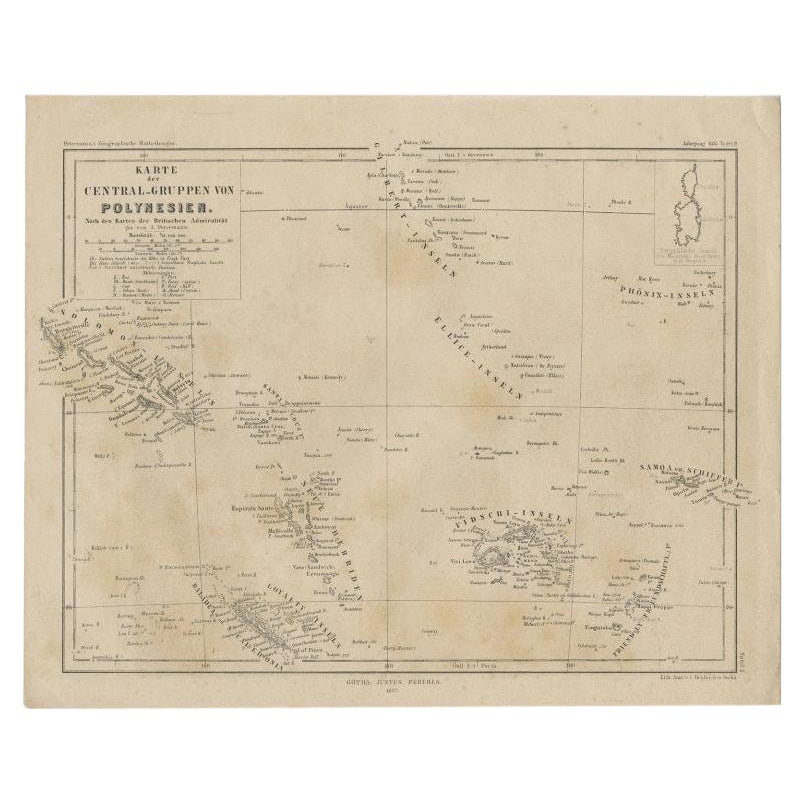
Old German Map Depicting the Central Islands of Polynesia, 1857
Located in Langweer, NL
Antique map Polynesia titled 'Karte der Central-Gruppen von Polynesien'. Old map depicting the central islands of Polynesia. This map originates from 'Petermanns Geographische Mittei...
Category
Antique 19th Century Maps
Materials
Paper
Antique Map of the Islands in the Pacific Ocean by Wyld, '1845'
Located in Langweer, NL
Antique map titled 'Islands in the Pacific Ocean'. Original antique map of the islands in the Pacific Ocean. This map originates from 'An Atlas of the World, Comprehending Separate M...
Category
Antique Mid-19th Century Maps
Materials
Paper

$188 Sale Price
20% Off
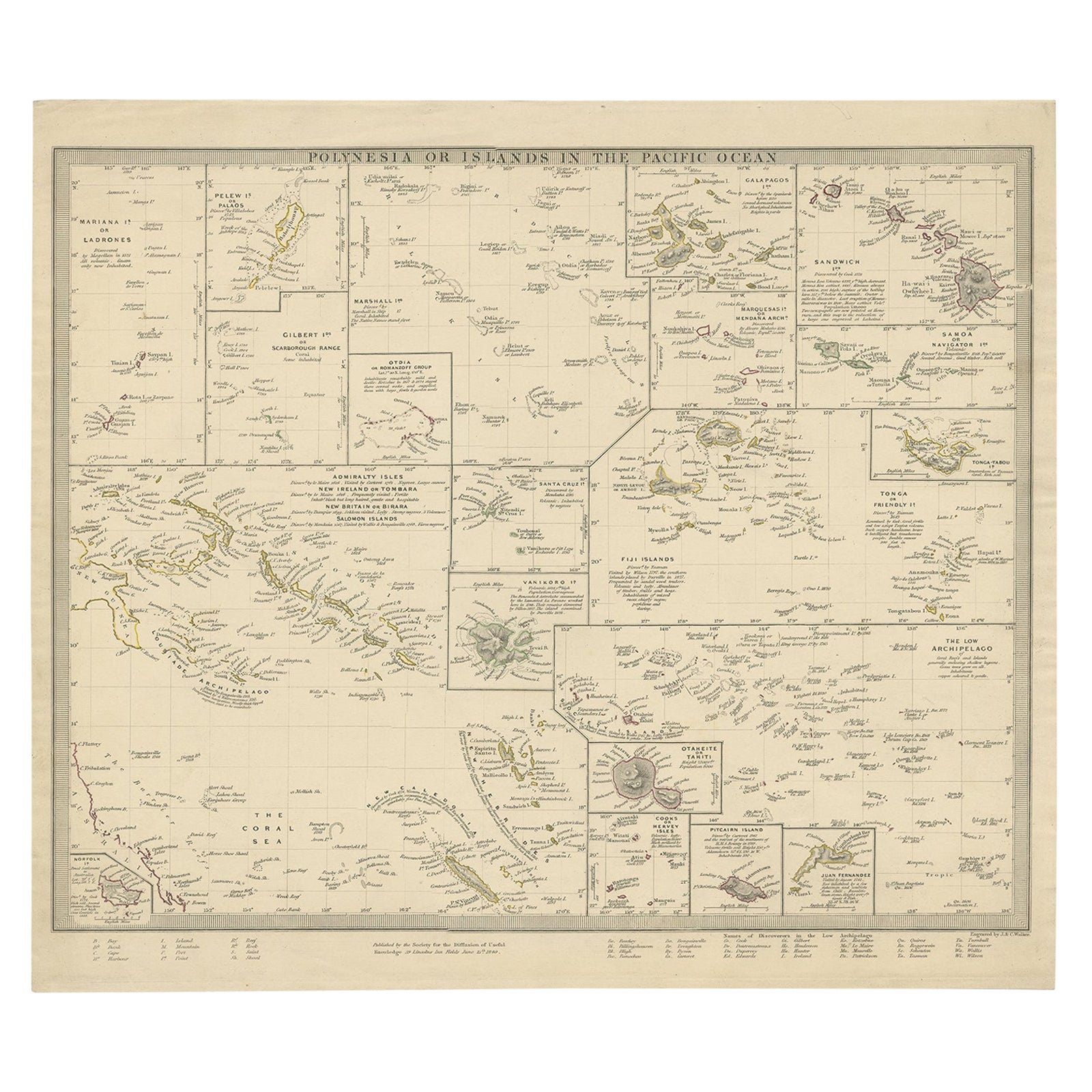
Antique Map of Polynesia with Details of Many Islands, 1840
Located in Langweer, NL
Antique map titled 'Polynesia or Islands in the Pacific Ocean'.
This map depicts various islands including the Lousiade Archipelago, Tahiti, Pitcairn Island, Juan Fernandez, The lo...
Category
Antique 19th Century Maps
Materials
Paper
Antique Map of Eastern Polynesia, 1849
Located in Langweer, NL
Antique map titled 'Ost-Polynesien'. Interesting variant issue, with large detailed insets top right of Hawaii volcanos near Kilauea. Insets lower right of Honolulu harbour, island o...
Category
Antique Mid-19th Century Maps
Materials
Paper

$165 Sale Price
30% Off
You May Also Like
Original Antique Map of US Possessions In The Pacific Ocean, C.1900
Located in St Annes, Lancashire
Fabulous map of US possessions in the Pacific Ocean
Original color.
Engraved and printed by the George F. Cram Company, Indianapolis.
Published, C.1900.
Unframed.
Free shipping.
Category
Antique 1890s American Maps
Materials
Paper

Large Original Antique Map of The Leeward Islands. 1894
Located in St Annes, Lancashire
Superb Antique map of The Leeward Islands
Published Edward Stanford, Charing Cross, London 1894
Original colour
Good condition
Unframed.
Free shipping
Category
Antique 1890s English Maps
Materials
Paper

Large Original Antique Map of The Pacific Ocean, Fullarton, C.1870
Located in St Annes, Lancashire
Great map of The Pacific Ocean
From the celebrated Royal Illustrated Atlas
Lithograph by Swanston. Original color.
Published by Fullarton,...
Category
Antique 1870s Scottish Maps
Materials
Paper

Large Original Antique Map of The Canary Islands. 1894
Located in St Annes, Lancashire
Superb Antique map of The Canary Islands
Published Edward Stanford, Charing Cross, London 1894
Original colour
Good condition
Unframed.
Free shipping
Category
Antique 1890s English Maps
Materials
Paper

Large Original Antique Map of the The Windward Islands. 1894
Located in St Annes, Lancashire
Superb Antique map of The Windward Islands
Published Edward Stanford, Charing Cross, London 1894
Original colour
Good condition
Unframed.
Free shipping
Category
Antique 1890s English Maps
Materials
Paper

Large Original Antique Map of The Bahamas. 1894
Located in St Annes, Lancashire
Superb Antique map of The Bahamas
Published Edward Stanford, Charing Cross, London 1894
Original colour
Good condition
Unframed.
Free shipping
Category
Antique 1890s English Maps
Materials
Paper

More Ways To Browse
Long Island Used Furniture
Long Island Artists
Hawk Antiques
Commodore Perry
Jamaican Antique
Hindeloopen Furniture
Romania Map
Stanford Antique Furniture
Sardinia Map
Victorian Staircase
Nantucket Map
Afghanistan Antique Map
Antique Map Of Hawaii
Antique Florida Map
Map Of Syria
Napoleon Map
South Arabian
Antique Geological Maps