Items Similar to Antique Map of the Breaches of the Oude Rijn River, C.1890


Want more images or videos?
Request additional images or videos from the seller
1 of 5
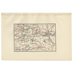
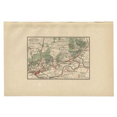
Antique Map of the Breaches of the Oude Rijn River, C.1890
$70.44
$88.0420% Off
£52.72
£65.9020% Off
€59.20
€7420% Off
CA$96.74
CA$120.9320% Off
A$108.17
A$135.2220% Off
CHF 56.74
CHF 70.9320% Off
MX$1,310.23
MX$1,637.7820% Off
NOK 716.24
NOK 895.3020% Off
SEK 676.68
SEK 845.8420% Off
DKK 450.71
DKK 563.3820% Off
About the Item
Antique map titled 'Schetsteekening van de bij den hoogen waterstand met ijsgang op den Ouden Rijn (..)'. Map illustrating the breaches of the Oude Rijn river near Babberich. Source unknown, to be determined. Published circa 1890. Artists and Engravers: Anonymous.
Artist: Anonymous.
Condition: Good, general age-related toning. Minor wear, small tear in lower margin. Blank verso, please study image carefully.
Date: c.1890
Overall size: 23.5 x 16.5 cm.
Image size: 0.001 x 19 x 11.5 cm.
Antique prints have long been appreciated for both their aesthetic and investment value. They were the product of engraved, etched or lithographed plates. These plates were handmade out of wood or metal, which required an incredible level of skill, patience and craftsmanship. Whether you have a house with Victorian furniture or more contemporary decor an old engraving can enhance your living space.
- Dimensions:Height: 6.5 in (16.5 cm)Width: 9.26 in (23.5 cm)Depth: 0 in (0.01 mm)
- Materials and Techniques:
- Period:
- Date of Manufacture:circa 1890
- Condition:
- Seller Location:Langweer, NL
- Reference Number:Seller: BV-00541stDibs: LU3054327770782
About the Seller
5.0
Recognized Seller
These prestigious sellers are industry leaders and represent the highest echelon for item quality and design.
Platinum Seller
Premium sellers with a 4.7+ rating and 24-hour response times
Established in 2009
1stDibs seller since 2017
2,565 sales on 1stDibs
Typical response time: <1 hour
- ShippingRetrieving quote...Shipping from: Langweer, Netherlands
- Return Policy
Authenticity Guarantee
In the unlikely event there’s an issue with an item’s authenticity, contact us within 1 year for a full refund. DetailsMoney-Back Guarantee
If your item is not as described, is damaged in transit, or does not arrive, contact us within 7 days for a full refund. Details24-Hour Cancellation
You have a 24-hour grace period in which to reconsider your purchase, with no questions asked.Vetted Professional Sellers
Our world-class sellers must adhere to strict standards for service and quality, maintaining the integrity of our listings.Price-Match Guarantee
If you find that a seller listed the same item for a lower price elsewhere, we’ll match it.Trusted Global Delivery
Our best-in-class carrier network provides specialized shipping options worldwide, including custom delivery.More From This Seller
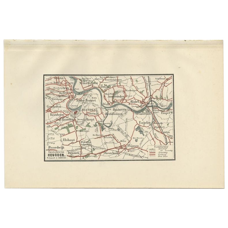
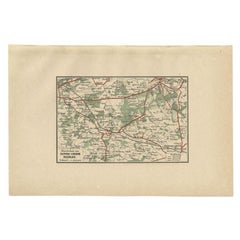
View AllAntique Map of the Region of Heusden by Craandijk, 1884
Located in Langweer, NL
Antique map titled 'Omstreken van Heusden'. Old map of the region of Heusden also including cities and villages like Elshout, Aalburg, Hedel and Vlijmen. This map orginates from 'Atl...
Category
Antique 19th Century Maps
Materials
Paper
$82 Sale Price
20% Off
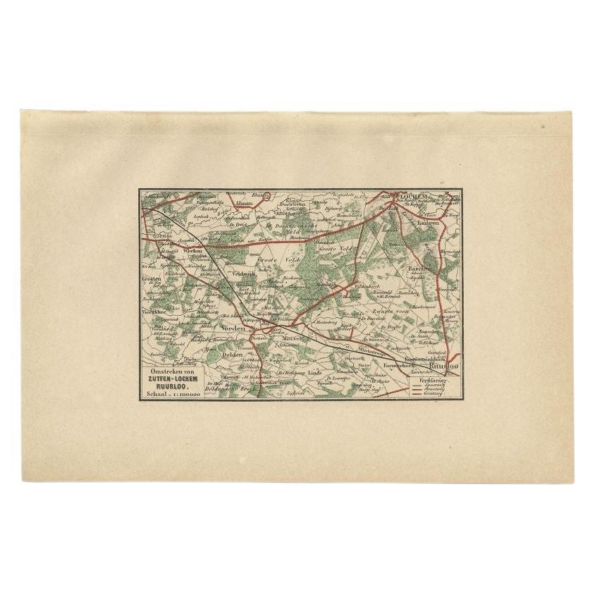
Antique Map of the Region of Zutphen by Craandijk, 1884
Located in Langweer, NL
Antique map titled 'Omstreken van Zutfen - Lochem Ruurlo'. Old map of the region of Zutphen also including cities and villages like Veldwijk, Vorden and Delden. This map orginates fr...
Category
Antique 19th Century Maps
Materials
Paper
$82 Sale Price
20% Off
Antique Map of The Dutch Township Rauwerderhem, 1861
Located in Langweer, NL
Antique map titled 'Gemeente Rauwerderhem'. Old map depicting the Rauwerderhem township including cities and villages like Deersum, Poppingawier, Rauwerd and Irnsum. This map orginat...
Category
Antique 19th Century Maps
Materials
Paper

$114 Sale Price
20% Off
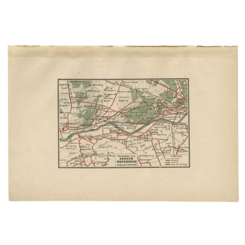
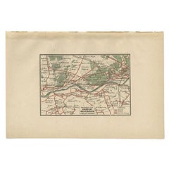
Antique Map of the Region of Arnhem and Wageningen by Craandijk, 1884
Located in Langweer, NL
Antique map titled 'Omstreken van Arnhem, Wageningen'. Old map of the region of Wageningen also including cities and villages like Bennekom, Renkum and Oosterbeek. This map orginates...
Category
Antique 19th Century Maps
Materials
Paper
$82 Sale Price
20% Off
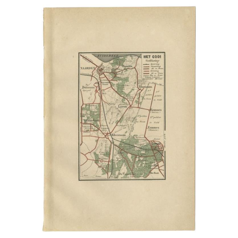
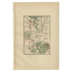
Antique Map of the Gooi Region by Craandijk, 1884
Located in Langweer, NL
Antique map titled 'Het Gooi'. Old map of the region of Hilversum also including cities and villages like Naarden, Laren, Blaricum, Eemnes and Baarn. This map orginates from 'Atlas b...
Category
Antique 19th Century Maps
Materials
Paper
$82 Sale Price
20% Off
Antique Map of the Region of Arnhem by Craandijk, 1884
Located in Langweer, NL
Antique map titled 'Omstreken van Arnhem - Dieren'. Old map of the region of Arnhem also including cities and villages like Rozendaal, Velp and Dieren. This map orginates from 'Atlas...
Category
Antique 19th Century Maps
Materials
Paper
$82 Sale Price
20% Off
You May Also Like
1839 Map of Karte Des "Russischen Reiches in Europa Und Asien" Ric.R0013
Located in Norton, MA
1839 map of Karte Des
"Russischen Reiches in Europa and Asien"
Ric.r013
Map of the European and Asian parts of Russian Empire. Karte der Russischen Reiches in Europa und Asien...
Category
Antique 19th Century Unknown Maps
Materials
Paper

Original Antique English County Map, Huntingdonshire, J & C Walker, 1851
Located in St Annes, Lancashire
Great map of Huntingdonshire
Original colour
By J & C Walker
Published by Longman, Rees, Orme, Brown & Co. 1851
Unframed.
Category
Antique 1850s English Other Maps
Materials
Paper

Original Antique English County Map, Cambridgeshire, J & C Walker, 1851
Located in St Annes, Lancashire
Great map of Cambridgeshire
Original colour
By J & C Walker
Published by Longman, Rees, Orme, Brown & Co. 1851
Unframed.
Category
Antique 1850s English Other Maps
Materials
Paper

Original Antique English County Map, Buckinghamshire, J & C Walker, 1851
Located in St Annes, Lancashire
Great map of Buckinghamshire
Original colour
By J & C Walker
Published by Longman, Rees, Orme, Brown & Co. 1851
Unframed.
Category
Antique 1850s English Other Maps
Materials
Paper

The Netherlands (Holland), Belgium and Luxemburg. Century Atlas antique map
Located in Melbourne, Victoria
'The Century Atlas. The Netherlands (Holland), Belgium and Luxemburg.'
Original antique map, 1903.
Inset maps of 'Amsterdam' and 'Brussels'.
Central fold as issued. Map name and num...
Category
Early 20th Century Victorian More Prints
Materials
Lithograph

Original Antique English County Map, Nottinghamshire, J & C Walker, 1851
Located in St Annes, Lancashire
Great map of Nottinghamshire
Original colour
By J & C Walker
Published by Longman, Rees, Orme, Brown & Co. 1851
Unframed.
Category
Antique 1850s English Other Maps
Materials
Paper

More Ways To Browse
Jamaican Antique
Hindeloopen Furniture
Romania Map
Stanford Antique Furniture
Sardinia Map
Victorian Staircase
Nantucket Map
Afghanistan Antique Map
Antique Map Of Hawaii
Antique Florida Map
Map Of Syria
Napoleon Map
South Arabian
Antique Geological Maps
French School Map
Nova Scotia Antique Furniture
Richard Wentworth
Antique Mace