Items Similar to Antique Map of The Dutch Township Rauwerderhem, 1861
Want more images or videos?
Request additional images or videos from the seller
1 of 5
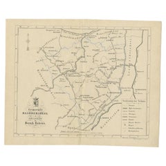
Antique Map of The Dutch Township Rauwerderhem, 1861
About the Item
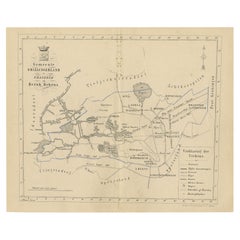
Antique map titled 'Gemeente Rauwerderhem'. Old map depicting the Rauwerderhem township including cities and villages like Deersum, Poppingawier, Rauwerd and Irnsum. This map orginates from 'Zak-Atlas van Friesland in 36 Kaarten'.
Artists and Engravers: Published by B. Behrns, Franeker.
Condition: Good, general age-related toning. Please study image carefully.
Date: 1861
Overall size: 20.9 x 17.2 cm.
Image size: 0.001 x 18.7 x 15.2 cm.
- Dimensions:Height: 6.78 in (17.2 cm)Width: 8.23 in (20.9 cm)Depth: 0 in (0.01 mm)
- Materials and Techniques:
- Period:
- Date of Manufacture:1861
- Condition:
- Seller Location:Langweer, NL
- Reference Number:
About the Seller
5.0
Platinum Seller
These expertly vetted sellers are 1stDibs' most experienced sellers and are rated highest by our customers.
Established in 2009
1stDibs seller since 2017
1,929 sales on 1stDibs
Typical response time: <1 hour
- ShippingRetrieving quote...Ships From: Langweer, Netherlands
- Return PolicyA return for this item may be initiated within 14 days of delivery.
More From This SellerView All
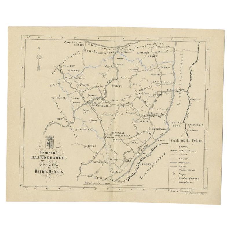
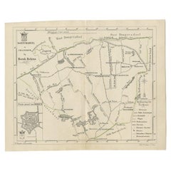
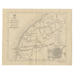
- Antique Map of the Dutch Township Baarderadeel, 1861Located in Langweer, NLAntique map titled 'Gemeente Baarderadeel'. Old map depicting the Baarderadeel township including cities and villages like Baard, Hilaard, Jorwerd, Oosterlittens and Oosterwierum. Th...Category
Antique 19th Century Maps
MaterialsPaper
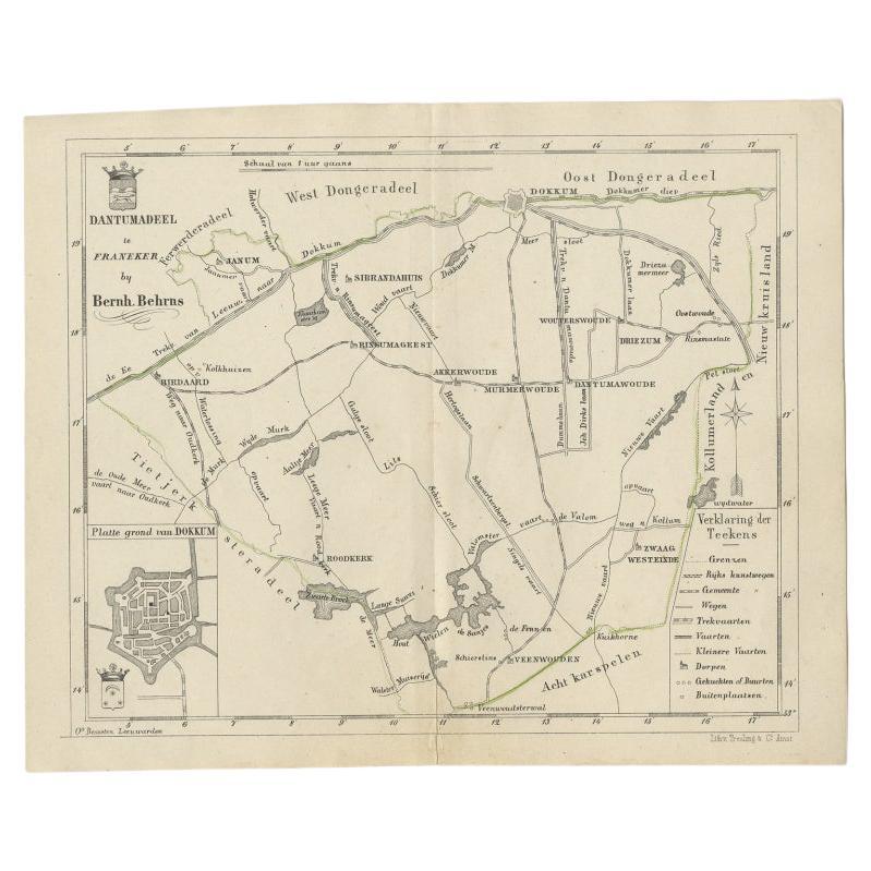
- Antique Map of the Dutch Dantumadeel Township, 1861Located in Langweer, NLAntique map titled 'Gemeente Dantumadeel'. Old map depicting the Dantumadeel township including cities and villages like Birdaard, Roodkerk, Veenwouden, Dantumawoude and Dokkum. This...Category
Antique 19th Century Maps
MaterialsPaper
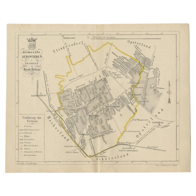
- Antique Map of the Dutch Township Aengwirden, 1861Located in Langweer, NLAntique map titled 'Gemeente Aengwirden'. Old map depicting the Aengwirden township including cities and villages like Tjalleberd, Luinjeberd, Terband and Gersloot. This map orginate...Category
Antique 19th Century Maps
MaterialsPaper
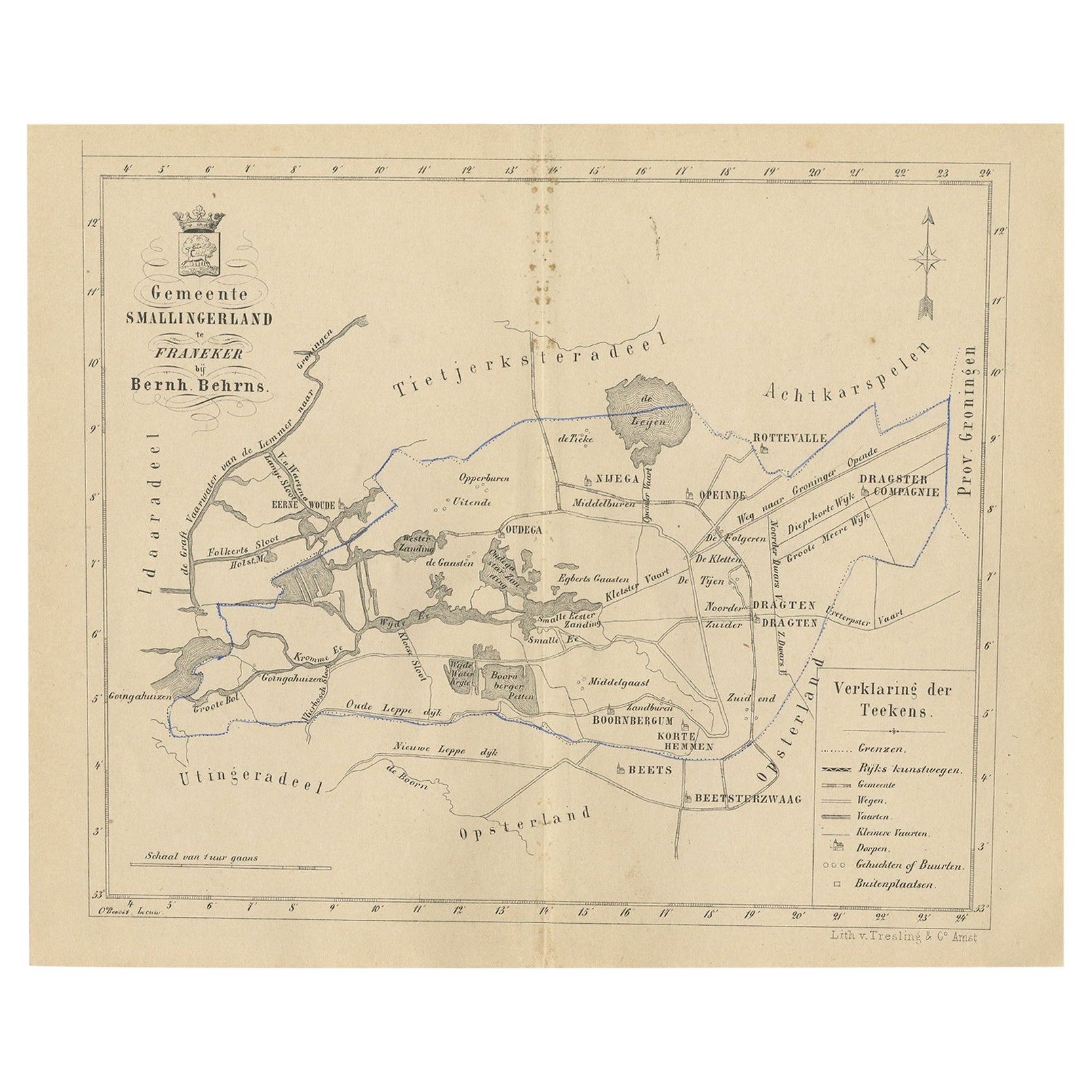
- Antique Map of The Dutch Smallingerland Township, 1861Located in Langweer, NLAntique map titled 'Gemeente Smallingerland'. Old map depicting the Smallingerland township including cities and villages like Eernewoude, Oudega, Boornbergum, Opeinde and Drachten. ...Category
Antique 19th Century Maps
MaterialsPaper
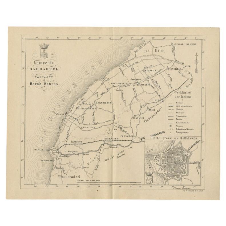
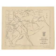
- Antique Dutch Map of The Barradeel Township by Behrns, 1861Located in Langweer, NLAntique map titled 'Gemeente Barradeel'. Old map depicting the Barradeel township including cities and villages like Midlum, Franeker, Dongjum, Minnertsga, Sexbierum and Harlingen. T...Category
Antique 19th Century Maps
MaterialsPaper
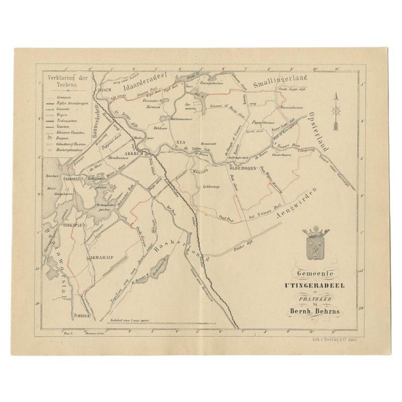
- Antique Map of the Dutch Utingeradeel Township by Behrns, 1861Located in Langweer, NLAntique map titled 'Gemeente Utingeradeel'. Old map depicting the Utingeradeel township including cities and villages like Akkrum, Nes, Terhorne and Akmarijp. This map orginates from...Category
Antique 19th Century Maps
MaterialsPaper

You May Also Like
- 1861 Topographical Map of the District of Columbia, by Boschke, Antique MapLocated in Colorado Springs, COPresented is an original map of Albert Boschke's extremely sought-after "Topographical Map of the District of Columbia Surveyed in the Years 1856 ...Category
Antique 1860s American Historical Memorabilia
MaterialsPaper
- Original Antique Map of Indonesia, 1861Located in St Annes, LancashireGreat map of Indonesia Drawn and engraved by Edward Weller Original color Published in The Weekly Dispatch Atlas, 1861 Repairs to minor e...Category
Antique 1860s English Victorian Maps
MaterialsPaper

- Original Large Antique Map of Paris, France by John Dower, 1861Located in St Annes, LancashireFabulous monochrome map of Paris. Vignettes of St Germain En Laye, Saint Cloud, Versailles and Fontainbleau. Unframed. Drawn by J.Dower. Lithography by Weller. 4 sheets j...Category
Antique 1860s English Victorian Maps
MaterialsPaper
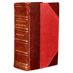
- 1861 The Book of Household ManagementBy Isabella BeetonLocated in Bath, GBThe first edition of Mrs Isabella Beeton's important cookery work, one of the most influential of its genre ever publisher, complete here with the original colour plates. The first ...Category
Antique 1860s Books
MaterialsPaper
- Original Antique Map of the American State of Pennsylvania, 1889Located in St Annes, LancashireGreat map of Pennsylvania Drawn and Engraved by W. & A.K. Johnston Published By A & C Black, Edinburgh. Original colour Unframed. Repair to a minor tear on bottom edge.Category
Antique 1880s Scottish Victorian Maps
MaterialsPaper
- Original Antique Map of the American State of Washington, 1889Located in St Annes, LancashireGreat map of Washington Drawn and Engraved by W. & A.K. Johnston Published By A & C Black, Edinburgh. Original colour Unframed.Category
Antique 1880s Scottish Victorian Maps
MaterialsPaper


Recently Viewed
View AllMore Ways To Browse
Map Globe
Globe Map
Framed Antique Map
Jacques Antiques
Africa Map
Map Of Africa
Large Metal Cross
Maps Of Africa
Antique German Map
Antique German Maps
Antique Map Germany
Antique Maps Germany
Antique Collectable Market
Antique Collectible Market
Antique House Windows
Antique Map Of Germany
Antique Maps Of Germany
Texas Antique Furniture