Items Similar to Antique Dutch Map of The Barradeel Township by Behrns, 1861

Want more images or videos?
Request additional images or videos from the seller
1 of 5
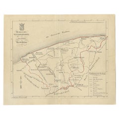
Antique Dutch Map of The Barradeel Township by Behrns, 1861
About the Item
Antique map titled 'Gemeente Barradeel'. Old map depicting the Barradeel township including cities and villages like Midlum, Franeker, Dongjum, Minnertsga, Sexbierum and Harlingen. This map orginates from 'Zak-Atlas van Friesland in 36 Kaarten'.
Artists and Engravers: Published by B. Behrns, Franeker.
Condition: Good, general age-related toning. Please study image carefully.
Date: 1861
Overall size: 21 x 17.2 cm.
Image size: 0.001 x 18.4 x 15.1 cm.
We sell original antique maps to collectors, historians, educators and interior decorators all over the world. Our collection includes a wide range of authentic antique maps from the 16th to the 20th centuries. Buying and collecting antique maps is a tradition that goes back hundreds of years. Antique maps have proved a richly rewarding investment over the past decade, thanks to a growing appreciation of their unique historical appeal. Today the decorative qualities of antique maps are widely recognized by interior designers who appreciate their beauty and design flexibility. Depending on the individual map, presentation, and context, a rare or antique map can be modern, traditional, abstract, figurative, serious or whimsical. We offer a wide range of authentic antique maps for any budget.
- Dimensions:Height: 6.78 in (17.2 cm)Width: 8.27 in (21 cm)Depth: 0 in (0.01 mm)
- Materials and Techniques:
- Period:
- Date of Manufacture:1861
- Condition:
- Seller Location:Langweer, NL
- Reference Number:
About the Seller
5.0
Platinum Seller
These expertly vetted sellers are 1stDibs' most experienced sellers and are rated highest by our customers.
Established in 2009
1stDibs seller since 2017
1,940 sales on 1stDibs
Typical response time: <1 hour
- ShippingRetrieving quote...Ships From: Langweer, Netherlands
- Return PolicyA return for this item may be initiated within 14 days of delivery.
More From This SellerView All
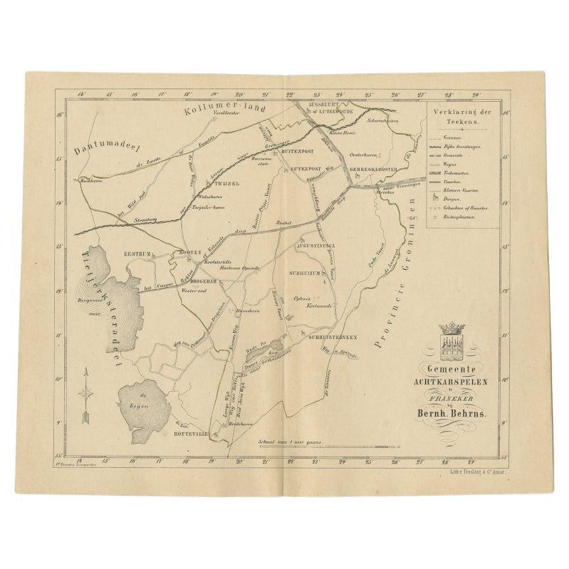
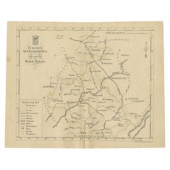
- Antique Map of The Dutch Achtkarspelen Township by Behrns, 1861Located in Langweer, NLAntique map titled 'Gemeente Achtkarspelen'. Old map depicting the Achtkarspelen township including cities and villages like Buitenpost, Twijzel, Drogeham and Surhuisterveen. This ma...Category
Antique 19th Century Maps
MaterialsPaper
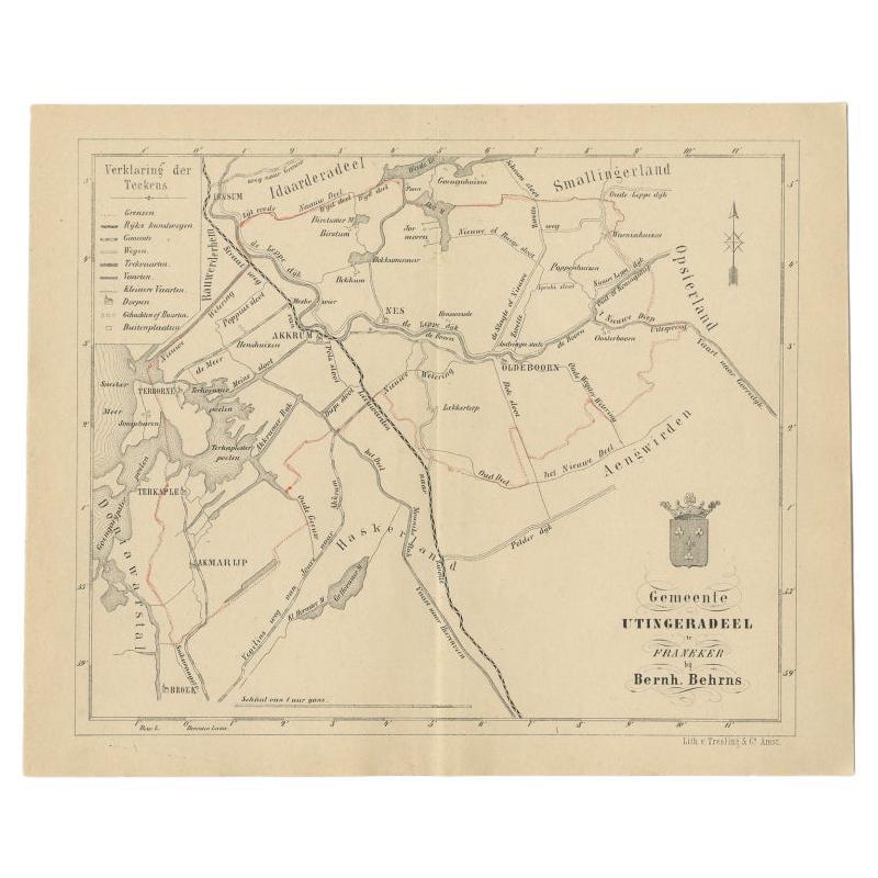
- Antique Map of the Dutch Utingeradeel Township by Behrns, 1861Located in Langweer, NLAntique map titled 'Gemeente Utingeradeel'. Old map depicting the Utingeradeel township including cities and villages like Akkrum, Nes, Terhorne and Akmarijp. This map orginates from...Category
Antique 19th Century Maps
MaterialsPaper
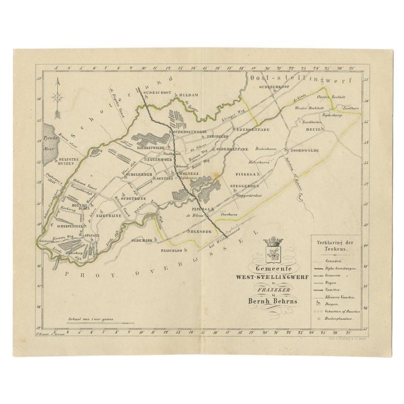
- Antique Map of The Dutch West-Stellingwerf Township by Behrns, 1861Located in Langweer, NLAntique map titled 'Gemeente West-Stellingwerf'. Old map depicting the West-Stellingwerf township including cities and villages like Noordwolde, Oldeholtwolde and Wolvega. This map o...Category
Antique 19th Century Maps
MaterialsPaper
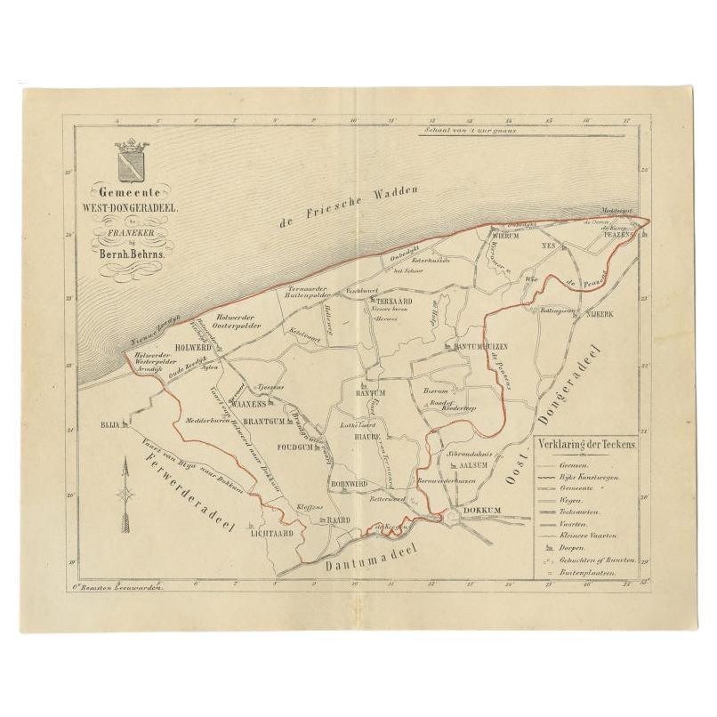
- Antique Map of The Dutch West-Dongeradeel Township by Behrns, 1861Located in Langweer, NLAntique map titled 'Gemeente West-Dongeradeel'. Old map depicting the West-Dongeradeel township including cities and villages like Holwerd, Ternaard, Hanrum and Raard. This map orgin...Category
Antique 19th Century Maps
MaterialsPaper
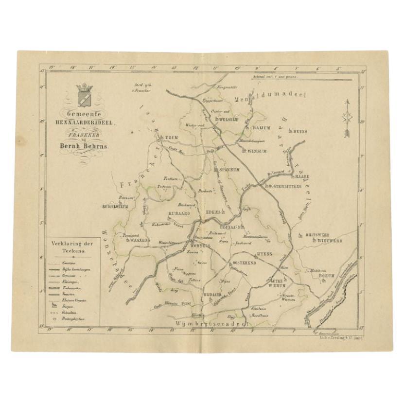
- Antique Map of the Hennaarderadeel Township by Behrns, 1861Located in Langweer, NLAntique map titled 'Gemeente Hennaarderadeel'. Old map depicting the Hennaarderadeel township including cities and villages like Kubaard, Wommels, Hennaard, Oosterend, Wierum, Tzum, ...Category
Antique 19th Century Maps
MaterialsPaper
- Antique Map of the Leeuwarderadeel Township by Behrns, 1861Located in Langweer, NLAntique map titled 'Gemeente Leeuwarderadeel'. Old map depicting the Leeuwarderadeel township including cities and villages like Finkum, Hijum, Stiens, Jelsum, Leeuwarden, Wirdum and...Category
Antique 19th Century Maps
MaterialsPaper

You May Also Like
- 1861 Topographical Map of the District of Columbia, by Boschke, Antique MapLocated in Colorado Springs, COPresented is an original map of Albert Boschke's extremely sought-after "Topographical Map of the District of Columbia Surveyed in the Years 1856 ...Category
Antique 1860s American Historical Memorabilia
MaterialsPaper
- Original Antique Map of Indonesia, 1861Located in St Annes, LancashireGreat map of Indonesia Drawn and engraved by Edward Weller Original color Published in The Weekly Dispatch Atlas, 1861 Repairs to minor e...Category
Antique 1860s English Victorian Maps
MaterialsPaper

- Original Large Antique Map of Paris, France by John Dower, 1861Located in St Annes, LancashireFabulous monochrome map of Paris. Vignettes of St Germain En Laye, Saint Cloud, Versailles and Fontainbleau. Unframed. Drawn by J.Dower. Lithography by Weller. 4 sheets j...Category
Antique 1860s English Victorian Maps
MaterialsPaper
- 1861 The Book of Household ManagementBy Isabella BeetonLocated in Bath, GBThe first edition of Mrs Isabella Beeton's important cookery work, one of the most influential of its genre ever publisher, complete here with the original colour plates. The first ...Category
Antique 1860s Books
MaterialsPaper
- The Holy Land at the Time of Jesus: A 17th Century Dutch Map by VisscherBy Nicolaes Visscher IILocated in Alamo, CAThis detailed Dutch map entitled "Het Beloofe de Landt Canaan door wandelt van onsen Salichmaecker Iesu Christo, nessens syne Apostelen" by Nicolaes Visscher was published in Amsterd...Category
Antique Mid-17th Century Dutch Maps
MaterialsPaper
- Original Antique Map of The World by Thomas Clerk, 1817Located in St Annes, LancashireGreat map of The Eastern and Western Hemispheres On 2 sheets Copper-plate engraving Drawn and engraved by Thomas Clerk, Edinburgh. Published by Mackenzie And Dent, 1817 ...Category
Antique 1810s English Maps
MaterialsPaper


Recently Viewed
View AllMore Ways To Browse
Dutch 16th Century Furniture
Zak Designs
Used Furniture Harlingen
Globe Map
Map Globe
Framed Antique Map
Jacques Antiques
Africa Map
Large Metal Cross
Maps Of Africa
Map Of Africa
Antique German Map
Antique German Maps
Antique Map Germany
Antique Maps Germany
Antique Collectible Market
Antique Collectable Market
Antique Map Of Germany