Items Similar to Antique Map of Champagne France by Johann Baptist Homann circa 1710 Hand-Colored


Want more images or videos?
Request additional images or videos from the seller
1 of 8
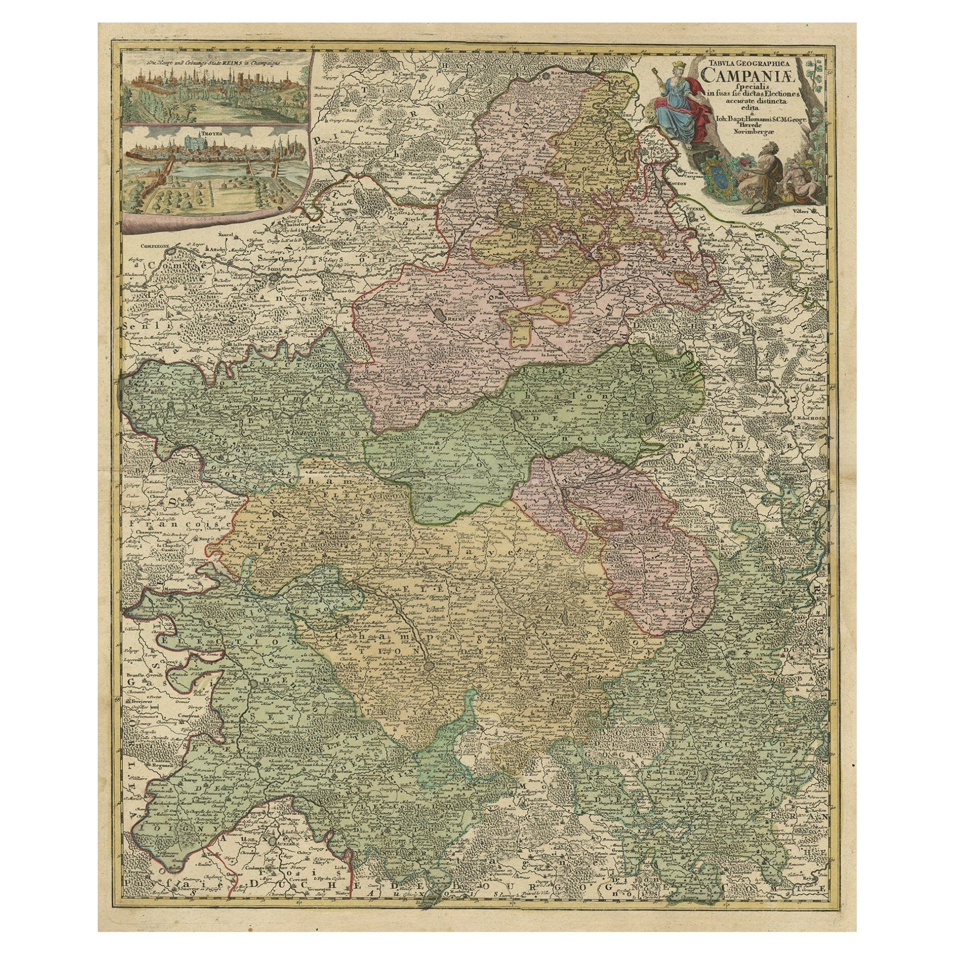
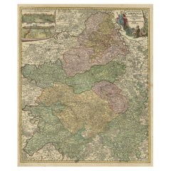
Antique Map of Champagne France by Johann Baptist Homann circa 1710 Hand-Colored
$527.18
£392.45
€440
CA$722.11
A$803.14
CHF 419.38
MX$9,773.40
NOK 5,356.08
SEK 5,023.05
DKK 3,349.57
Shipping
Retrieving quote...The 1stDibs Promise:
Authenticity Guarantee,
Money-Back Guarantee,
24-Hour Cancellation
About the Item
Antique Map of Champagne France by Johann Baptist Homann circa 1710 Hand-Colored
This richly detailed antique map titled Tabula Geographica Campaniae Galliae depicts the historic province of Champagne in northeastern France. Created by the esteemed German cartographer Johann Baptist Homann in the early 18th century, this map provides a comprehensive view of the region’s political and geographical divisions. The hand-colored engraving highlights the distinct administrative areas, with major cities, towns, rivers, forests, and road networks meticulously represented. The map reflects Homann’s expertise in cartographic precision, combining artistic embellishment with scientific accuracy.
A striking feature of this map is the elaborate title cartouche in the upper right corner, adorned with allegorical figures symbolizing the agricultural and viticultural wealth of the Champagne region. The map also includes two detailed city views in the upper left corner, showcasing panoramic perspectives of key urban centers such as Reims and Troyes. The finely engraved typography and clear demarcation of territories make this an invaluable historical document for scholars and collectors interested in early French cartography.
Condition summary
This antique map is in good condition, with vibrant original hand coloring that enhances the territorial divisions. The paper has developed a warm patina, characteristic of maps from this period. There is some age toning and minor foxing, particularly along the margins, which is typical for 18th-century prints. The edges exhibit slight wear, including small creases and minor tears that do not affect the main engraved area. The central fold remains visible, as expected for an atlas map, with no significant damage. The details and inscriptions remain crisp and legible, preserving the historical and aesthetic integrity of the piece.
Framing tips
To properly preserve and showcase this antique map, it is recommended to use archival-quality materials. UV-protective glass or acrylic will prevent fading of the hand coloring. Acid-free matting in neutral tones will enhance the clarity of the engraved details while protecting the paper from environmental damage. A period-appropriate wooden frame, either dark-stained or gilded, will complement the historical character of the map. Museum-grade mounting techniques should be employed to ensure the longevity of this unique cartographic work. This map makes an exceptional decorative and scholarly addition to a collection, offering historical insight into one of France’s most significant regions.
- Dimensions:Height: 24.02 in (61 cm)Width: 20.48 in (52 cm)Depth: 0.01 in (0.2 mm)
- Materials and Techniques:Paper,Engraved
- Period:1720-1729
- Date of Manufacture:circa 1720
- Condition:The condition reflects its age, with gentle toning, slight foxing, mild edge wear and wrinkles. Some tape support on the reverse. Details remain legible, and the coloring and engraving are still clear.
- Seller Location:Langweer, NL
- Reference Number:Seller: BG-13659-11stDibs: LU3054343856682
About the Seller
5.0
Recognized Seller
These prestigious sellers are industry leaders and represent the highest echelon for item quality and design.
Platinum Seller
Premium sellers with a 4.7+ rating and 24-hour response times
Established in 2009
1stDibs seller since 2017
2,510 sales on 1stDibs
Typical response time: <1 hour
- ShippingRetrieving quote...Shipping from: Langweer, Netherlands
- Return Policy
Authenticity Guarantee
In the unlikely event there’s an issue with an item’s authenticity, contact us within 1 year for a full refund. DetailsMoney-Back Guarantee
If your item is not as described, is damaged in transit, or does not arrive, contact us within 7 days for a full refund. Details24-Hour Cancellation
You have a 24-hour grace period in which to reconsider your purchase, with no questions asked.Vetted Professional Sellers
Our world-class sellers must adhere to strict standards for service and quality, maintaining the integrity of our listings.Price-Match Guarantee
If you find that a seller listed the same item for a lower price elsewhere, we’ll match it.Trusted Global Delivery
Our best-in-class carrier network provides specialized shipping options worldwide, including custom delivery.More From This Seller
View AllOld Map of Region Champagne-Ardenne with Reims, Troyes & Épernay in France, 1759
Located in Langweer, NL
Antique map titled 'Tabula Geographica Campaniae (..).'
Detailed map of the Champagne region in France by J. B. Homann, covering the region Champagne-Ardenne with Reims, Troyes a...
Category
Antique 1750s Maps
Materials
Paper
$704 Sale Price
30% Off
Antique Map of the Lorraine 'North-East France' by J. B. Homann, circa 1720
Located in Langweer, NL
Antique map of Lorraine in north-east France by J. B. Homann. Covering the area around Metz, Nancy and Sarrebruck with Luxembourg in the North and Mulhouse in Southeast. With a decor...
Category
Antique Early 18th Century Maps
Materials
Paper

$613 Sale Price
20% Off
Antique Hand-Colored Map of France by J.B. Elwe, 1792
Located in Langweer, NL
Antique map titled 'Carte Nouvelle du Royaume de France'. Beautiful antique map of France, including the Southern part of England. Decorated with cartouche and 12 coats of arms.
Category
Antique Late 18th Century Maps
Materials
Paper

Antique Map of the Alsace Region of France by Schenk 'circa 1700'
Located in Langweer, NL
Antique map titled 'Superioris atque Inferioris Alsatiae'. Beautiful map of the Alsace region, from Basel in the south to Philipsburg in the north, centered on Strassburg. Published ...
Category
Antique Early 18th Century Maps
Materials
Paper

$575 Sale Price
20% Off
Hand-Colored 17th-Century Map of Orléanais in France by Frederik De Wit c. 1688
Located in Langweer, NL
Title: Hand-Colored 17th-Century Map of Orléanais by Frederik De Wit c. 1688
Description: This beautifully crafted map, "Gouvernement General du Pays Orléanois," illustrates the Orl...
Category
Antique 1680s Maps
Materials
Paper

Antique Map of the Artois Region 'France' by F. de Wit, circa 1680
Located in Langweer, NL
Antique map titled 'Tabula Comitatus Artesiae emendata'. Large map of the Artois region, France. Published by F. de Wit, circa 1680.
Category
Antique Late 17th Century Maps
Materials
Paper

$516 Sale Price
25% Off
You May Also Like
18th Century Hand-Colored Homann Map of Germany, Including Frankfurt and Berlin
By Johann Baptist Homann
Located in Alamo, CA
An 18th century hand-colored map entitled "Tabula Marchionatus Brandenburgici et Ducatus Pomeraniae quae sunt Pars Septentrionalis Circuli Saxoniae Superioris" by Johann Baptist Homa...
Category
Antique Early 18th Century German Maps
Materials
Paper

17th Century Hand-Colored Map of a Region in West Germany by Janssonius
By Johannes Janssonius
Located in Alamo, CA
This attractive highly detailed 17th century original hand-colored map is entitled "Archiepiscopatus Maghdeburgensis et Anhaltinus Ducatus cum terris adjacentibus". It was published ...
Category
Antique Mid-17th Century Dutch Maps
Materials
Paper

17th Century Hand Colored Map of the Liege Region in Belgium by Visscher
By Nicolaes Visscher II
Located in Alamo, CA
An original 17th century map entitled "Leodiensis Episcopatus in omnes Subjacentes Provincias distincté divisusVisscher, Leodiensis Episcopatus" by Nicolaes Visscher II, published in Amsterdam in 1688. The map is centered on Liege, Belgium, includes the area between Antwerp, Turnhout, Roermond, Cologne, Trier and Dinant.
This attractive map is presented in a cream-colored mat measuring 30" wide x 27.5" high. There is a central fold, as issued. There is minimal spotting in the upper margin and a tiny spot in the right lower margin, which are under the mat. The map is otherwise in excellent condition.
The Visscher family were one of the great cartographic families of the 17th century. Begun by Claes Jansz Visscher...
Category
Antique Late 17th Century Dutch Maps
Materials
Paper

Hand Colored 18th Century Homann Map of Austria Including Vienna and the Danube
By Johann Baptist Homann
Located in Alamo, CA
"Archiducatus Austriae inferioris" is a hand colored map of Austria created by Johann Baptist Homann (1663-1724) and published in Nuremberg, Germany in 1728 shortly after his death. ...
Category
Antique Early 18th Century German Maps
Materials
Paper

The Normandy Region of France: A 17th C. Hand-colored Map by Sanson and Jaillot
By Nicolas Sanson
Located in Alamo, CA
This large hand-colored map entitled "Le Duché et Gouvernement de Normandie divisée en Haute et Basse Normandie en divers Pays; et par evêchez, avec le Gouvernement General du Havre ...
Category
Antique 1690s French Maps
Materials
Paper

1771 Bonne Map of Poitou, Touraine and Anjou, France, Ric.a015
Located in Norton, MA
1771 Bonne Map of Poitou,
Touraine and Anjou, France
Ric.a015
1771 Bonne map of Potiou, Touraine and Anjou entitled "Carte des Gouvernements D'Anjou et du Saumurois, de la Touraine, du Poitou,du Pays d'aunis, Saintonge?Angoumois,"
Carte des gouvernements d'Anjou et du Saumurois, de la Touraine, du Poitou, du Pays d'Aunis, Saintonge-Angoumois. Projettee et assujettie au ciel par M. Bonne, Hyd. du Roi. A Paris, Chez Lattre, rue St. Jacques a la Ville de Bord(ea)ux. Avec priv. du Roi. 1771. Arrivet inv. & sculp., Atlas moderne ou collection de cartes sur toutes...
Category
Antique 17th Century Unknown Maps
Materials
Paper

More Ways To Browse
French Matting
Vintage Scandanavian Chairs
19th Century Red Glass
Antique French Console Table Tables
Silver Bowl Large
Antique French Silk
Down Couch
Used Lighter Art
Blue Edge Glass
Mahogany 1950s Furniture
Solid Mahogany Table
Dessert Glasses
Geometric Glass Table
Mid Century Pin
6x10 Rug
Studded Furniture
Styles Of Antique Desks
Black And White Coffee Table