Items Similar to Antique Map of Gallia and Germania on one Sheet, c.1703


Want more images or videos?
Request additional images or videos from the seller
1 of 10
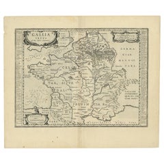
Antique Map of Gallia and Germania on one Sheet, c.1703
$230.04
$287.5520% Off
£171.22
£214.0320% Off
€192
€24020% Off
CA$315.10
CA$393.8820% Off
A$350.46
A$438.0820% Off
CHF 183
CHF 228.7520% Off
MX$4,264.75
MX$5,330.9420% Off
NOK 2,337.20
NOK 2,921.5020% Off
SEK 2,191.88
SEK 2,739.8520% Off
DKK 1,461.63
DKK 1,827.0420% Off
Shipping
Retrieving quote...The 1stDibs Promise:
Authenticity Guarantee,
Money-Back Guarantee,
24-Hour Cancellation
About the Item
Antique map depicting France (Gallia) and Germany (Germania). Printed for Scherer's 'Atlas Novus' (1702-1710).
Artists and Engravers: Heinrich Scherer (1628-1704) was a Professor of Hebrew, Mathematics and Ethics at the University of Dillingen until about 1680. Thereafter he obtained important positions as Official Tutor to the Royal Princes of Mantua and Bavaria. It was during his time in Munich as Tutor to the Princely house of Bavaria that his lifetime’s work as a cartographer received acclaim and recognition. Scherer’s world atlas, the Atlas Novus, first published in Munich between 1702 and 1710 and reissued in a second edition between 1730 and 1737, forms a singularly unusual, almost revolutionary work in terms of the development of European mapmaking at the beginning of the 18th Century.
Condition: Very good. General age-related toning. Please study image carefully.
Date: c.1703
Overall size: 21 x 27 cm.
Image size: 18 x 23.5 cm.
- Dimensions:Height: 10.63 in (27 cm)Width: 8.27 in (21 cm)Depth: 0 in (0.01 mm)
- Materials and Techniques:Paper,Engraved
- Place of Origin:
- Period:
- Date of Manufacture:circa 1703
- Condition:
- Seller Location:Langweer, NL
- Reference Number:Seller: BGI-014901stDibs: LU3054326190822
About the Seller
5.0
Recognized Seller
These prestigious sellers are industry leaders and represent the highest echelon for item quality and design.
Platinum Seller
Premium sellers with a 4.7+ rating and 24-hour response times
Established in 2009
1stDibs seller since 2017
2,502 sales on 1stDibs
Typical response time: <1 hour
- ShippingRetrieving quote...Shipping from: Langweer, Netherlands
- Return Policy
Authenticity Guarantee
In the unlikely event there’s an issue with an item’s authenticity, contact us within 1 year for a full refund. DetailsMoney-Back Guarantee
If your item is not as described, is damaged in transit, or does not arrive, contact us within 7 days for a full refund. Details24-Hour Cancellation
You have a 24-hour grace period in which to reconsider your purchase, with no questions asked.Vetted Professional Sellers
Our world-class sellers must adhere to strict standards for service and quality, maintaining the integrity of our listings.Price-Match Guarantee
If you find that a seller listed the same item for a lower price elsewhere, we’ll match it.Trusted Global Delivery
Our best-in-class carrier network provides specialized shipping options worldwide, including custom delivery.More From This Seller
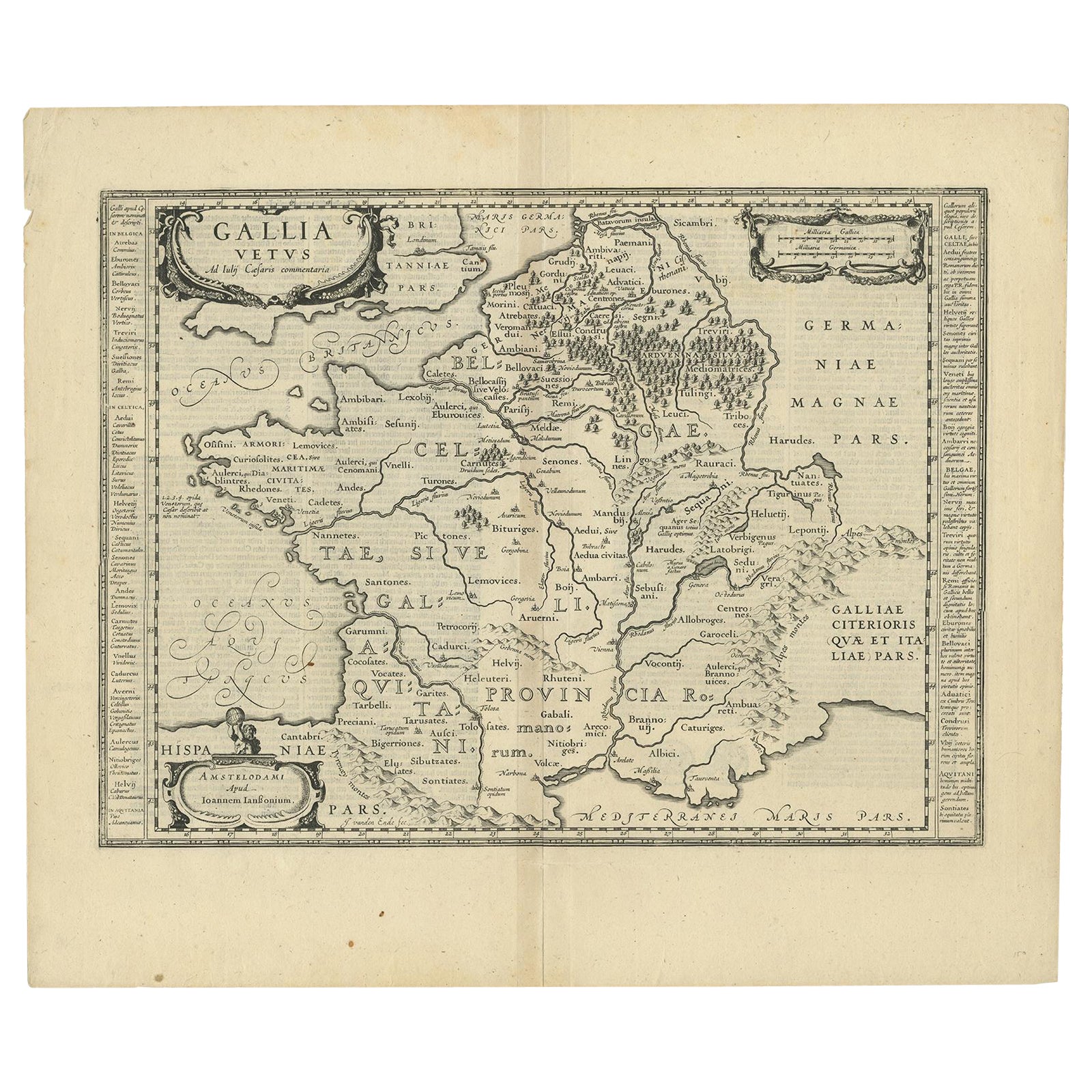
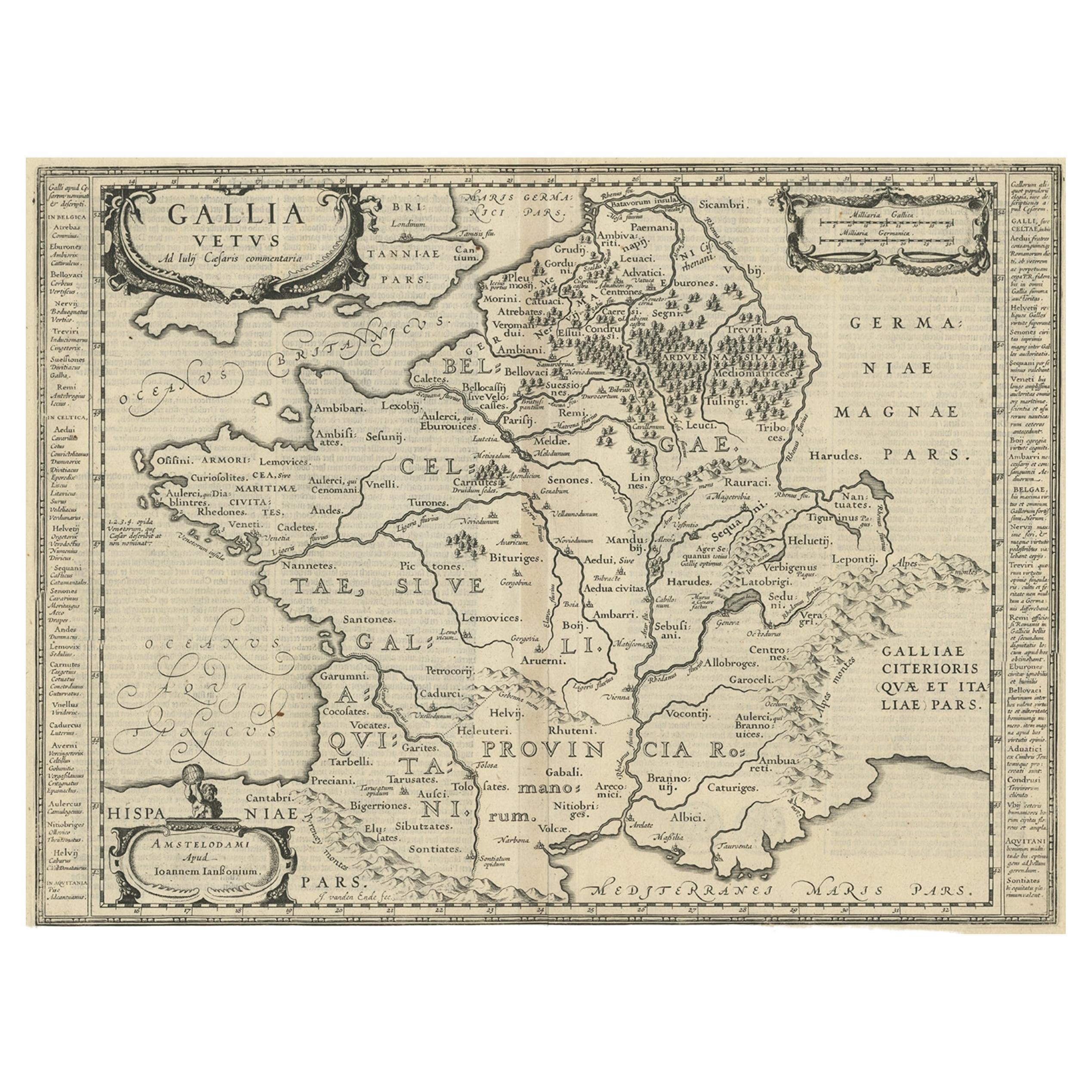
View AllAntique Map of France by Janssonius, c.1650
Located in Langweer, NL
Antique map titled 'Gallia Vetus'. Beautiful map of France based on Caesar's De Bello Gallico. In the columns to the left and right important tribes and people are described.
Art...
Category
Antique 17th Century Maps
Materials
Paper
$503 Sale Price
20% Off
Antique Map of France by Janssonius, c.1650
Located in Langweer, NL
Antique map titled 'Gallia Vetus'. Beautiful map of France based on Caesar's De Bello Gallico. In the columns to the left and right important tribes and people are described.
Art...
Category
Antique 17th Century Maps
Materials
Paper
$503 Sale Price
20% Off
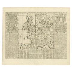
Antique Map of the British Isles and Part of Europe by Chatelain, c.1720
Located in Langweer, NL
Antique map titled 'Carte pour l'Intelligence de l'Histoire d'Angleterre (..)'. Decorative map showing the British Isles and the various regions conquered in Europe. Includese two elaborate family trees for the House of York...
Category
Antique 18th Century Maps
Materials
Paper
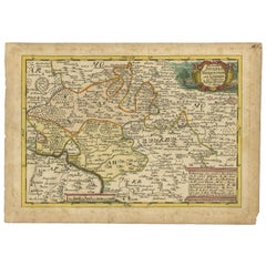
Antique Map of Germany of German in Roman Times, c.1660
Located in Langweer, NL
Antique map Germany titled 'Germaniae Veteris Typus'. Antique map probably by Blaeu or based on an earlier state by W. Blaeu.
Minor differences shown in the cartouches. Top left ha...
Category
Antique 17th Century Maps
Materials
Paper

$814 Sale Price
20% Off
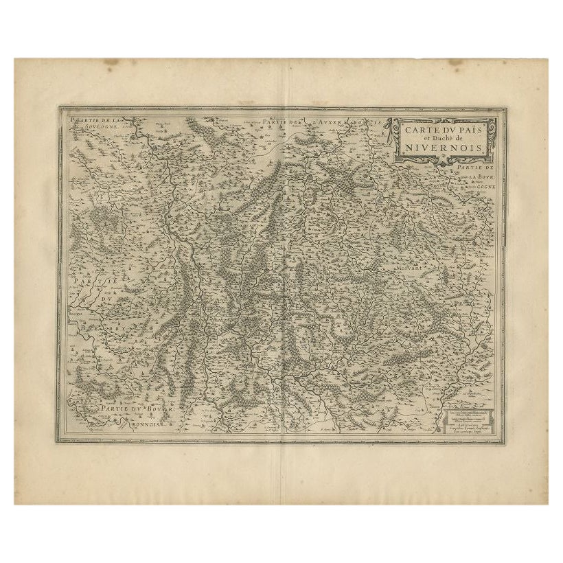
Antique Map of the Region of Nivernais by Janssonius, 1657
By Johannes Janssonius
Located in Langweer, NL
Antique map of France titled 'Carte du Païs et Duché de Nivernois'. Decorative map of the Nivernais region, part of Burgundy, France. This map originates from 'Atlas Novus, Sive Thea...
Category
Antique 17th Century Maps
Materials
Paper

$372 Sale Price
20% Off
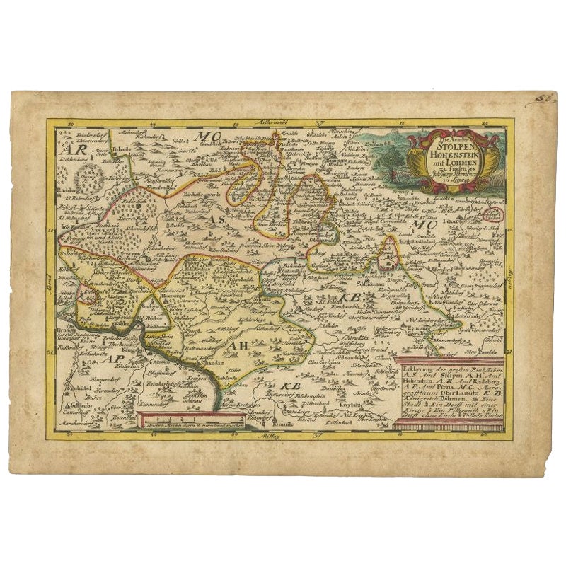
Antique Map of the Region of Hohenstein by Schreiber, 1749
Located in Langweer, NL
Antique map titled 'Aemter Stolpen, Hohenstein mit Lohmen'. Map of the region of Hohenstein, Germany. This map originates from 'Atlas Selectus von allen Konigreichen und Landern der ...
Category
Antique 18th Century Maps
Materials
Paper
$89 Sale Price
20% Off
You May Also Like
1657 Janssonius Map of Vermandois and Cappelle, Ric. A-004
Located in Norton, MA
1657 Janssonius map of
Vermandois and Cappelle
Ric.a004
Description: Antique map of France titled 'Descriptio Veromanduorum - Gouvernement de la Cappelle'. Two detailed maps o...
Category
Antique 17th Century Unknown Maps
Materials
Paper

1640 Joan Bleau Map Entitled"Diocecese de rheims et le pais de rethel, " Eic.a011
Located in Norton, MA
1640 Joan Bleau map entitled
"Diocecese de rheims et le pais de rethel,"
Ric.a011
OAN BLAEU
Diocecese de Rheims, et le pais de Rethel.
Handcolored engraving, c.1640.
...
Category
Antique 17th Century Dutch Maps
Materials
Paper

Antique Map - Gallia - Etching by Johannes Janssonius - 1650s
By Johannes Janssonius
Located in Roma, IT
Antique Map - Gallia is an antique map realized in 1650 by Johannes Janssonius (1588-1664).
The Map is Hand-colored etching, with coeval watercoloring.
Good conditions with slight ...
Category
1650s Modern Figurative Prints
Materials
Etching

Original Antique Map of Switzerland, Engraved By Barlow, Dated 1807
Located in St Annes, Lancashire
Great map of Switzerland
Copper-plate engraving by Barlow
Published by Brightly & Kinnersly, Bungay, Suffolk.
Dated 1807
Unframed.
Category
Antique Early 1800s English Maps
Materials
Paper

17th Century Hand Colored Map of the Liege Region in Belgium by Visscher
By Nicolaes Visscher II
Located in Alamo, CA
An original 17th century map entitled "Leodiensis Episcopatus in omnes Subjacentes Provincias distincté divisusVisscher, Leodiensis Episcopatus" by Nicolaes Visscher II, published in Amsterdam in 1688. The map is centered on Liege, Belgium, includes the area between Antwerp, Turnhout, Roermond, Cologne, Trier and Dinant.
This attractive map is presented in a cream-colored mat measuring 30" wide x 27.5" high. There is a central fold, as issued. There is minimal spotting in the upper margin and a tiny spot in the right lower margin, which are under the mat. The map is otherwise in excellent condition.
The Visscher family were one of the great cartographic families of the 17th century. Begun by Claes Jansz Visscher...
Category
Antique Late 17th Century Dutch Maps
Materials
Paper

1714 Henri Chatelain "Nouvelle Carte Des Etatas Du Grand.Duc De Mos Moscovie Eur
Located in Norton, MA
A 1714 Henri Chatelain map, entitled
"Nouvelle Carte Des Etatas Du Grand Duc De Moscovie En Europe,"
Ricb001
Henri Abraham Chatelain (1684-1743) was a Huguenot pastor of Parisi...
Category
Antique Early 18th Century Dutch Maps
Materials
Paper

More Ways To Browse
Royal Prince
Heinrich Bavaria
Antique Gallia
Antique Railroad Collectibles
Blaeu World Map
Roman Empire Map
Antique Map Of Middle East
Caribbean Map
Antique Map Of Egypt
Antique Map Ortelius
Antique Farm Antiques Collectibles
Antique Galleon
Biblical Maps
Medieval Capital
Civil War Map
Map Of Singapore
Migeon Migeon
Scottish Coat Of Arms