Items Similar to Antique Map of Jamaica and Hispaniola (Saint-Domingue and Santo Domingo), 1802


Want more images or videos?
Request additional images or videos from the seller
1 of 8
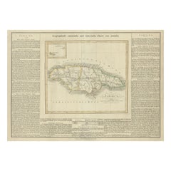
Antique Map of Jamaica and Hispaniola (Saint-Domingue and Santo Domingo), 1802
$529.29
$661.6120% Off
£396.74
£495.9220% Off
€448
€56020% Off
CA$727.16
CA$908.9420% Off
A$811.80
A$1,014.7520% Off
CHF 425.37
CHF 531.7120% Off
MX$9,937.24
MX$12,421.5520% Off
NOK 5,402.22
NOK 6,752.7820% Off
SEK 5,093.61
SEK 6,367.0120% Off
DKK 3,410.34
DKK 4,262.9220% Off
About the Item
This is an original antique map titled "Carte des Isles de la Jamaïque et de St. Domingue," depicting the islands of Jamaica and Saint-Domingue (modern-day Haiti and the Dominican Republic). Created by Pierre Antoine Tardieu, this map provides a detailed view of the geographical and political landscape of these significant Caribbean islands in the early 19th century.
Map Details:
- **Title**: Carte des Isles de la Jamaïque et de St. Domingue
- **Creator**: Pierre Antoine Tardieu (1784-1869)
- **Publication Date**: Early 19th century
- **Dimensions**: Approximately 34.5 x 43.5 cm (13.5 x 17.25 inches)
- **Features**: The map includes detailed representations of Jamaica and Saint-Domingue, highlighting political boundaries, major cities, rivers, and other geographical features. The title cartouche is located in the lower right corner, and the outlines are hand-colored to distinguish different regions.
Key Geographic Features and Areas:
1. **Jamaica**:
- The map shows Jamaica with detailed markings of its parishes, key towns, and geographical features such as rivers and mountain ranges.
- Important locations such as Kingston, Port Royal, and Montego Bay are depicted.
2. **Saint-Domingue (Hispaniola)**:
- The island of Saint-Domingue is detailed, showing the division between the French-controlled western part (Haiti) and the Spanish-controlled eastern part (Santo Domingo, now the Dominican Republic).
- Key locations such as Cap-Français (Cap-Haïtien), Port-au-Prince, and Santo Domingo are marked.
- The map also highlights the island's rivers, mountains, and coastal features.
Condition Overview:
1. **Paper Quality**: The paper shows typical signs of aging, such as slight yellowing, but remains in good condition without major tears or damage.
2. **Edges and Corners**: The edges are slightly worn, with minor fraying and small tears, particularly near the center fold. These imperfections do not significantly impact the overall readability or aesthetic value.
3. **Center Fold**: A center fold is present, which is common for maps of this period that were often folded for storage or publication. The fold appears intact without significant separation or damage.
4. **Color and Print Quality**: The hand-colored outlines remain vibrant and clear, highlighting the borders of different regions. The print quality is excellent, with sharp, legible text and detailed illustrations.
5. **Staining and Spots**: There are a few spots and stains, particularly near the edges and along the fold. These do not obscure any critical details of the map.
Historical Context
Political Landscape
1. **Jamaica**:
- Jamaica was a British colony, significant for its sugar plantations and strategic location in the Caribbean. It was a major hub for the British slave trade and plantation economy.
2. **Saint-Domingue**:
- The island of Hispaniola was divided between the French colony of Saint-Domingue (now Haiti) and the Spanish colony of Santo Domingo (now the Dominican Republic).
- Saint-Domingue was one of the wealthiest colonies in the Caribbean due to its sugar, coffee, and indigo plantations, relying heavily on enslaved African labor.
### Socio-Economic Conditions
1. **Agriculture and Plantations**:
- Both Jamaica and Saint-Domingue had economies based on plantation agriculture, producing sugar, coffee, tobacco, and other cash crops.
- These plantations were labor-intensive and relied on the transatlantic slave trade for a steady supply of enslaved workers.
2. **Trade and Commerce**:
- Major ports such as Kingston in Jamaica and Cap-Français in Saint-Domingue were crucial hubs for trade. Goods were exported to Europe and other parts of the Americas.
- The Caribbean Sea was a vital route for the movement of goods, people, and ships.
Cultural and Social Aspects
1. **Diverse Populations**:
- The population in these islands included European colonists, African slaves, and free people of color. Cultural interactions and exchanges were common, leading to a rich blend of traditions and customs.
2. **Colonial Influence**:
- European colonial powers, particularly the British and French, influenced the cultural, religious, and social structures of these islands. Their customs and governance systems shaped the development of the colonies.
Conflicts and Changes
1. **Haitian Revolution**:
- The Haitian Revolution (1791-1804) was a significant event that led to the establishment of Haiti as the first independent black republic. This revolution had a profound impact on the entire Caribbean region.
- The map reflects the political changes occurring during this period, with Saint-Domingue transitioning from French control to independence.
2. **Piracy and Naval Conflicts**:
- The Caribbean was a hotspot for piracy and naval conflicts as European powers vied for control of trade routes and territories.
Summary
Jamaica and Saint-Domingue around 1800 were regions of significant political importance, economic activity, and cultural diversity. The map by Pierre Antoine Tardieu provides a detailed and historically valuable representation of these Caribbean islands, reflecting the geographical and political complexities of the time.
- Dimensions:Height: 16.34 in (41.5 cm)Width: 22.25 in (56.5 cm)Depth: 0.01 in (0.2 mm)
- Materials and Techniques:Paper,Engraved
- Period:
- Date of Manufacture:1802
- Condition:Good condition with minor age-related wear. Hand-colored boundaries are well-preserved, enhancing the clarity of regions and features. Fold lines as issued. Damp spot at bottom edge. Some wear due to handling and age. Study the images carefully.
- Seller Location:Langweer, NL
- Reference Number:Seller: BG-13769-391stDibs: LU3054340578882
About the Seller
5.0
Recognized Seller
These prestigious sellers are industry leaders and represent the highest echelon for item quality and design.
Platinum Seller
Premium sellers with a 4.7+ rating and 24-hour response times
Established in 2009
1stDibs seller since 2017
2,513 sales on 1stDibs
Typical response time: <1 hour
- ShippingRetrieving quote...Shipping from: Langweer, Netherlands
- Return Policy
Authenticity Guarantee
In the unlikely event there’s an issue with an item’s authenticity, contact us within 1 year for a full refund. DetailsMoney-Back Guarantee
If your item is not as described, is damaged in transit, or does not arrive, contact us within 7 days for a full refund. Details24-Hour Cancellation
You have a 24-hour grace period in which to reconsider your purchase, with no questions asked.Vetted Professional Sellers
Our world-class sellers must adhere to strict standards for service and quality, maintaining the integrity of our listings.Price-Match Guarantee
If you find that a seller listed the same item for a lower price elsewhere, we’ll match it.Trusted Global Delivery
Our best-in-class carrier network provides specialized shipping options worldwide, including custom delivery.More From This Seller
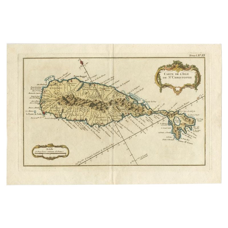
View AllOld Map of the island of Saint Christopher or St. Kitts in the Caribbean, c.1765
Located in Langweer, NL
Antique map titled 'Carte de l'Isle de Saint-Christophe'.
A detailed map of the island of Saint Christopher or St. Kitts showing mountain ranges, port towns and parishes. This map ...
Category
Antique 18th Century Maps
Materials
Paper

Authentic Antique Map of the Caribbean, Gulf Coast and Central America, 1787
Located in Langweer, NL
Antique map titled 'Les Isles Antilles et le Golfe du Méxique'. Original old map of the Caribbean, Gulf Coast and Central America. With inset map of Bermuda...
Category
Antique Late 18th Century Maps
Materials
Paper

$293 Sale Price
20% Off
Free Shipping
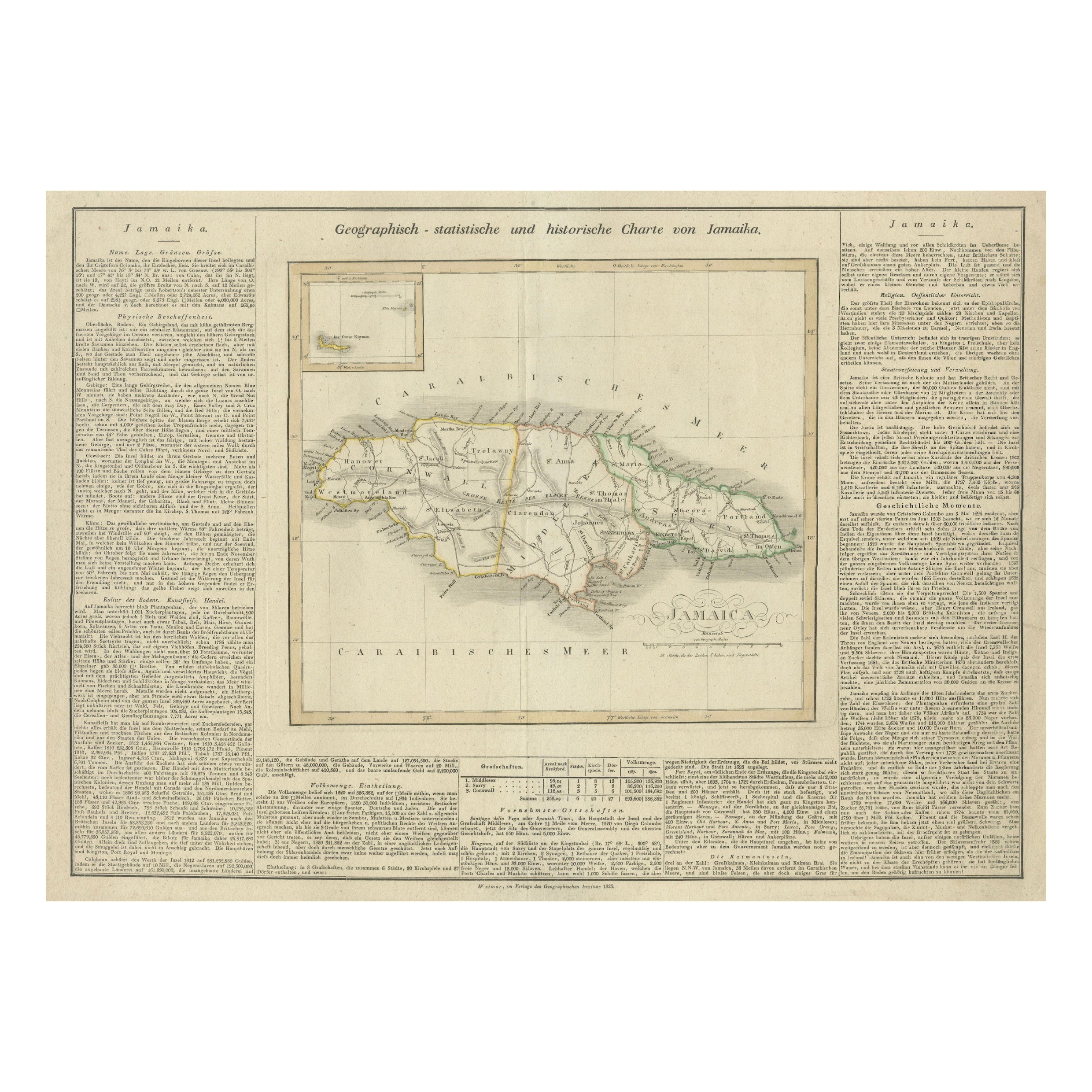
Detailed Antique Map of Jamaica - Published in Weimar, 1825
Located in Langweer, NL
This map of Jamaica is an interesting historical document.
This map is part of an atlas that was issued in six editions in English, French, and German ...
Category
Antique 1820s Maps
Materials
Paper
$510 Sale Price
20% Off
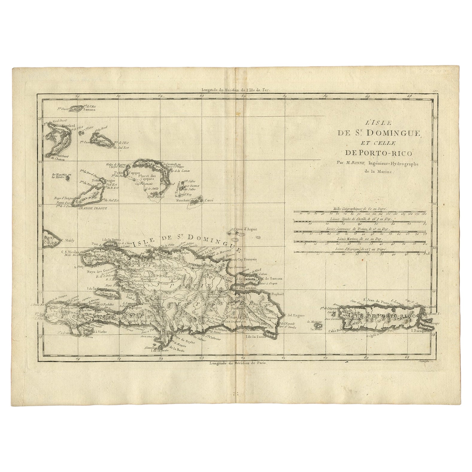
Detailed Antique Map of Santa Domingo, Puerto Rico, Eastern Bahamas, ca. 1780
Located in Langweer, NL
Description: Antique map titled 'L'Isle De St. Domingue, et celle De Porto-Rico.'
Detailed map of Santa Domingo, Puerto Rico, etc. Includes substanti...
Category
Antique 1780s Maps
Materials
Paper
$661 Sale Price
20% Off
Original Antique Map of the West Indies by J. Arrowsmith, 1842
Located in Langweer, NL
Title: "J. Arrowsmith's 19th Century Map of the West Indies"
This original antique map, crafted by J. Arrowsmith, details the West Indies with a focus on the Caribbean Sea and its s...
Category
Antique Early 19th Century Maps
Materials
Paper

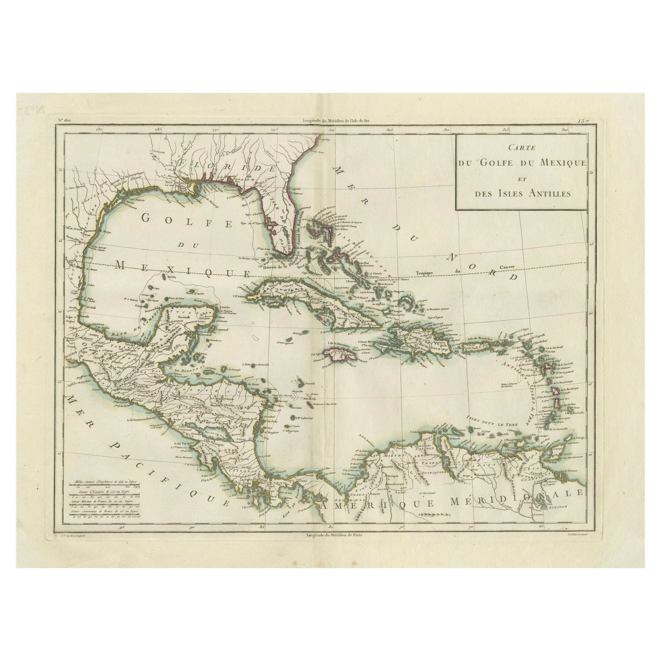
Antique Map of the Gulf of Mexico and Caribbean Islands by Tardieu, 1802
Located in Langweer, NL
This is an original antique map titled "Carte du Golfe du Mexique et des Isles Antilles," depicting the Gulf of Mexico and the Caribbean islands. Created by Pierre Antoine Tardieu, t...
Category
Antique Early 1800s Maps
Materials
Paper
$529 Sale Price
20% Off
You May Also Like
St. Christophe 'St. Kitts' Island: An 18th Century Hand-colored Map by Bellin
By Jacques-Nicolas Bellin
Located in Alamo, CA
Jacques Bellin's copper-plate map of the Caribbean island of Saint Kitts entitled "Carte De De l'Isle St. Christophe Pour servir á l'Histoire Genle. des V...
Category
Antique Mid-18th Century French Maps
Materials
Paper

Large Original Antique Map of The West Indies by Sidney Hall, 1847
Located in St Annes, Lancashire
Great map of The West Indies
Drawn and engraved by Sidney Hall
Steel engraving
Original colour outline
Published by A & C Black. 1847
Unframed
Free shipping.
Category
Antique 1840s Scottish Maps
Materials
Paper

Original Antique Map of Central America / Florida, Arrowsmith, 1820
Located in St Annes, Lancashire
Great map of Central America.
Drawn under the direction of Arrowsmith.
Copper-plate engraving.
Published by Longman, Hurst, Rees, Orme and Brown, 1820
Unframed.
Category
Antique 1820s English Maps
Materials
Paper

Map Colonies Francaises Martinique, 1845
Located in BUNGAY, SUFFOLK
Colonies Francaises, Martinique, Amerique DU SUD
Geographie et Statistique par V.Levasseur. Ing'r Geographe.
Illustre par Raymond Bonheur, peintre.
Grave par Laguihermie, Rue St...
Category
Antique 19th Century French Maps
Materials
Paper

St. Christophe (St. Kitts): Bellin 18th Century Hand Colored Map
Located in Alamo, CA
Jacques Bellin's copper-plate map of the Caribbean island of Saint Kitts entitled "Carte De De l'Isle St. Christophe Pour servir á l'Histoire Genle. des V...
Category
1740s Other Art Style Landscape Prints
Materials
Engraving

Early 19th Century Hand Colored Map of the United States and Caribbean Islands
Located in Hamilton, Ontario
Hand coloured early 19th century map by Giraldon of France titled "Etats Unis et Grandes Antilles" (United States and Greater Antilles).
Category
Antique Early 19th Century French Maps
Materials
Paper

$595 Sale Price
40% Off
More Ways To Browse
Antique Santos
French Santos
Map Storage
Spanish Santos
Used Furniture Jamaica
Antique Plantation Furniture
Religious Santos
Spanish Colonial Santos
Antique Map Storage
Silver Over Copper
Vintage Barware Glasses
Coffee Table Black Italian Modern
Christofle America
Iranian Silk Rug Carpet
Poul Moller
Tables With Inlaid Wood
World War Table
Antonio Jacobsen