Items Similar to Antique Map of Japan by W. G. Blackie, 1859


Want more images or videos?
Request additional images or videos from the seller
1 of 6
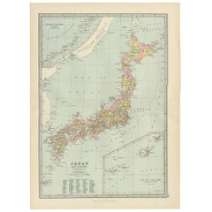
Antique Map of Japan by W. G. Blackie, 1859
$174.70
$232.9425% Off
£132.34
£176.4625% Off
€150
€20025% Off
CA$242.03
CA$322.7025% Off
A$271.45
A$361.9325% Off
CHF 142.15
CHF 189.5425% Off
MX$3,298.40
MX$4,397.8625% Off
NOK 1,805.13
NOK 2,406.8425% Off
SEK 1,711.39
SEK 2,281.8525% Off
DKK 1,142.06
DKK 1,522.7525% Off
About the Item
Antique map titled 'Japan'. Original antique map of Japan. This map originates from ‘The Imperial Atlas of Modern Geography’. Published by W. G. Blackie, 1859.
- Dimensions:Height: 14.57 in (37 cm)Width: 10.63 in (27 cm)Depth: 0.02 in (0.5 mm)
- Materials and Techniques:
- Period:
- Date of Manufacture:1859
- Condition:Wear consistent with age and use. General age-related toning. some foxing, Please study image carefully.
- Seller Location:Langweer, NL
- Reference Number:Seller: BG-12685-1-531stDibs: LU3054325241972
About the Seller
5.0
Recognized Seller
These prestigious sellers are industry leaders and represent the highest echelon for item quality and design.
Platinum Seller
Premium sellers with a 4.7+ rating and 24-hour response times
Established in 2009
1stDibs seller since 2017
2,517 sales on 1stDibs
Typical response time: <1 hour
- ShippingRetrieving quote...Shipping from: Langweer, Netherlands
- Return Policy
Authenticity Guarantee
In the unlikely event there’s an issue with an item’s authenticity, contact us within 1 year for a full refund. DetailsMoney-Back Guarantee
If your item is not as described, is damaged in transit, or does not arrive, contact us within 7 days for a full refund. Details24-Hour Cancellation
You have a 24-hour grace period in which to reconsider your purchase, with no questions asked.Vetted Professional Sellers
Our world-class sellers must adhere to strict standards for service and quality, maintaining the integrity of our listings.Price-Match Guarantee
If you find that a seller listed the same item for a lower price elsewhere, we’ll match it.Trusted Global Delivery
Our best-in-class carrier network provides specialized shipping options worldwide, including custom delivery.More From This Seller
View AllAntique Map of Japan, the Kurile Islands and Liu Kiu Islands, 1886
Located in Langweer, NL
The map is an exquisite piece, showcasing Japan's vibrant geography. Engraved by J. Bartholomew and published by George Philip & Son in London & Liverpool, it presents a detailed and...
Category
Antique Late 19th Century Maps
Materials
Paper
$111 Sale Price
20% Off
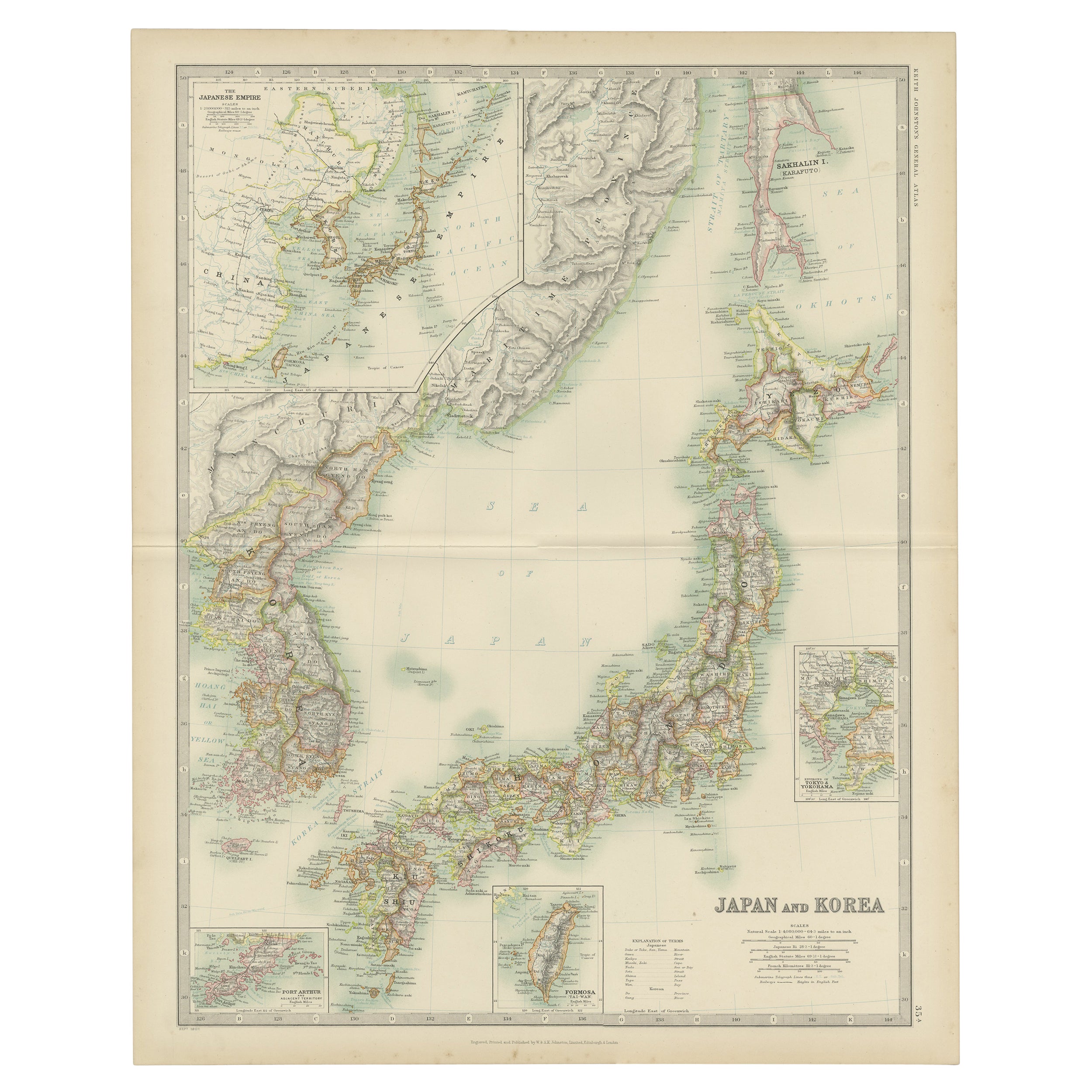
Antique Map of Japan and Korea by Johnston '1909'
Located in Langweer, NL
Antique map titled 'Japan and Korea'. Original antique map of Japan and Korea. With inset maps of the Japanese Empire, Port Arthur, Formosa ,Tokyo and Yoko...
Category
Early 20th Century Maps
Materials
Paper
$326 Sale Price
20% Off
Antique Map of China and Japan by A.K. Johnston, 1865
Located in Langweer, NL
Antique map titled 'China and Japan'. Depicting Eastern China, the Islands of Japan and more. This map originates from the ‘Royal Atlas of Modern Geography’ by Alexander Keith Johnst...
Category
Antique Mid-19th Century Maps
Materials
Paper

$279 Sale Price
20% Off
Antique Map of China and Japan by Johnson, 1872
Located in Langweer, NL
Antique map titled 'Johnson's China and Japan'. Map of China and Japan, with an inset map of the vicinity of Canton and Hong Kong. This map originates from 'Johnson's New Illustrated...
Category
Antique Late 19th Century Maps
Materials
Paper

$279 Sale Price
20% Off
Antique Map of the Region of Tokyo and Nagasaki in Japan, 1922
Located in Langweer, NL
Antique map of Japan titled 'Japan - Environs of Tokio & Nagasaki'. Old map of Japan, includes inset maps of Tokyo, Nagasaki and surroundings. This map or...
Category
20th Century Maps
Materials
Paper

$167 Sale Price
20% Off
Antique Map of China and Japan by Tardieu, 1821
Located in Langweer, NL
Antique map titled 'Carte de la Chine et du Japon'. Detailed map of China, showing Korea, Japan and Taiwan. This map originates from 'L'histoire général des voyages' by J.F. de la Harpe.
Category
Antique Early 19th Century Maps
Materials
Paper

$675 Sale Price
20% Off
You May Also Like
Large Original Vintage Map of Japan, circa 1920
Located in St Annes, Lancashire
Great map of Japan
Unframed
Original color
By John Bartholomew and Co. Edinburgh Geographical Institute
Published, circa 1920
Free shipping.
Category
Vintage 1920s British Maps
Materials
Paper

Large Original Vintage Map of Japan, circa 1920
Located in St Annes, Lancashire
Great map of Japan
Original color. Good condition
Published by Alexander Gross
Unframed.
Category
Vintage 1920s English Maps
Materials
Paper

China and Japan, English antique map by Alexander Keith Johnston, 1901
Located in Melbourne, Victoria
'China and Japan', antique lithographic map by Keith Johnston.
Central vertical fold as issued.
495mm by 625mm (sheet)
Alexander Keith Johnston FRS...
Category
Early 20th Century Victorian More Prints
Materials
Lithograph

Large Original Antique Map of Asia by Sidney Hall, 1847
Located in St Annes, Lancashire
Great map of Asia
Drawn and engraved by Sidney Hall
Steel engraving
Original colour outline
Published by A & C Black. 1847
Unframed
Free shipping
Category
Antique 1840s Scottish Maps
Materials
Paper

Original Antique Map of China, Arrowsmith, 1820
Located in St Annes, Lancashire
Great map of China
Drawn under the direction of Arrowsmith
Copper-plate engraving
Published by Longman, Hurst, Rees, Orme and Brown, 1820
Unfr...
Category
Antique 1820s English Maps
Materials
Paper

Antique 1803 Italian Map of Asia Including China Indoneseia India
Located in Amsterdam, Noord Holland
Antique 1803 Italian Map of Asia Including China Indoneseia India
Very nice map of Asia. 1803.
Additional information:
Type: Map
Country of Manufacturing: Europe
Period: 19th centu...
Category
Antique 19th Century European Maps
Materials
Paper

$584 Sale Price
20% Off
More Ways To Browse
Japan Antiques Collectables
Map New Holland
Treasure Map
Caribbean Antiques
19th Century Map Of Africa
Antique Malaysia
Antique Map Of Ireland
Ships Log
Map Of Egypt
Nautical Maps
Antique Maps Of Long Island
James Cook Map
Antique Doctors Office Furniture
Pirate Furniture
Railroad Collectibles
Antique Map Mexico
Framed Map Of Paris
Antique Map Of Rome