Items Similar to Sweden and Scandinavia – Antique Map by F.L. Güssefeld, Homann Heirs, c.1793s


Video Loading
Want more images or videos?
Request additional images or videos from the seller
1 of 12
Sweden and Scandinavia – Antique Map by F.L. Güssefeld, Homann Heirs, c.1793s
$226.43
$283.0320% Off
£169.49
£211.8620% Off
€192
€24020% Off
CA$311.63
CA$389.5420% Off
A$347.34
A$434.1820% Off
CHF 182.24
CHF 227.8020% Off
MX$4,241.61
MX$5,302.0220% Off
NOK 2,307.54
NOK 2,884.4220% Off
SEK 2,180.97
SEK 2,726.2220% Off
DKK 1,461.64
DKK 1,827.0520% Off
About the Item
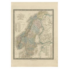
Sweden and Scandinavia – Antique Map by F.L. Güssefeld, Homann Heirs, c.1793s
This finely engraved antique map, titled Charte über das Königreich Schweden, presents an expansive view of the Kingdom of Sweden and its surrounding regions during the late 18th century. The map was created by Franz Ludwig Güssefeld, one of the most respected German cartographers of his time, and likely published by the Homann Heirs in Nuremberg—one of Europe’s leading mapmaking firms in the 18th century.
The map displays Sweden in impressive detail, extending from Scania in the south to Lapland in the north. It also includes large portions of neighboring Norway, Finland (then under Swedish control), and the Baltic coastline, providing important geopolitical context. Regional borders, cities, towns, rivers, lakes, and mountain ranges are clearly engraved, with original hand-coloring used to delineate territories. The legend at upper left lists major provinces and towns, and the large oval title cartouche anchors the lower right corner.
Güssefeld’s work is known for its geographic precision and clarity, and this map reflects the transition in cartography from ornate baroque styles to more scientifically grounded and information-rich designs. It would have served both educational and reference purposes for scholars and political observers of the period.
This map is a valuable artifact for collectors of Scandinavian cartography, German engraving, or Enlightenment-era geography, offering insight into the shifting political landscapes of Northern Europe.
Condition report: Fair condition. General age-related toning throughout. There is a central horizontal fold with a small split at the fold line. Minor wear to edges and corners. Blank verso. Please examine image closely for details.
Framing tips: A wide, neutral mat in parchment or ivory tones with a gold or dark wood frame will emphasize the historical character. Archival glass is recommended to preserve the delicate hand-coloring.
Date: 1793
Overall size: 54 x 65 cm.
Image size: 45 x 58.5 cm.
- Dimensions:Height: 25.6 in (65 cm)Width: 21.26 in (54 cm)Depth: 0 in (0.01 mm)
- Materials and Techniques:Paper,Engraved
- Place of Origin:
- Period:
- Date of Manufacture:1793
- Condition:Good condition. General age-related toning throughout. There is a central horizontal fold with a small split at the fold line. Minor wear to edges and corners. Blank verso. Please examine image closely for details.
- Seller Location:Langweer, NL
- Reference Number:Seller: BG-12526-31stDibs: LU3054327833042
About the Seller
5.0
Recognized Seller
These prestigious sellers are industry leaders and represent the highest echelon for item quality and design.
Platinum Seller
Premium sellers with a 4.7+ rating and 24-hour response times
Established in 2009
1stDibs seller since 2017
2,513 sales on 1stDibs
Typical response time: <1 hour
- ShippingRetrieving quote...Shipping from: Langweer, Netherlands
- Return Policy
Authenticity Guarantee
In the unlikely event there’s an issue with an item’s authenticity, contact us within 1 year for a full refund. DetailsMoney-Back Guarantee
If your item is not as described, is damaged in transit, or does not arrive, contact us within 7 days for a full refund. Details24-Hour Cancellation
You have a 24-hour grace period in which to reconsider your purchase, with no questions asked.Vetted Professional Sellers
Our world-class sellers must adhere to strict standards for service and quality, maintaining the integrity of our listings.Price-Match Guarantee
If you find that a seller listed the same item for a lower price elsewhere, we’ll match it.Trusted Global Delivery
Our best-in-class carrier network provides specialized shipping options worldwide, including custom delivery.More From This Seller
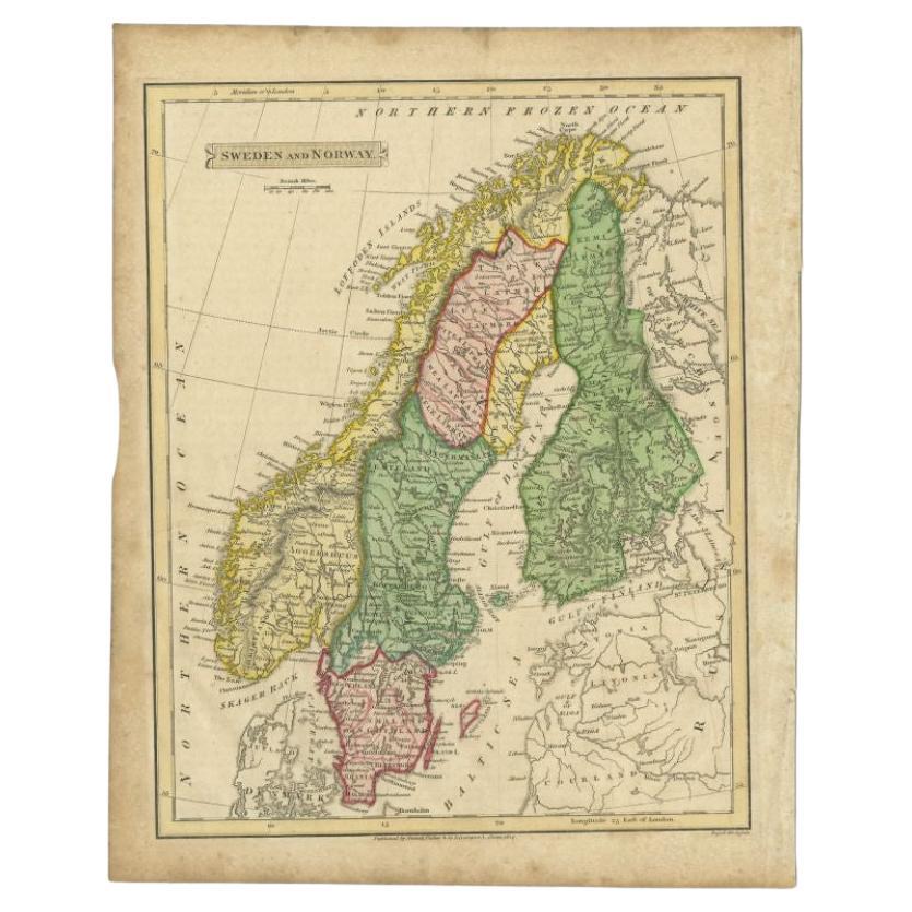
View AllAntique Map of Sweden and Norway by Russell, 1814
Located in Langweer, NL
Antique map Scandinavia titled 'Sweden & Norway'. Antique map of Scandinavia with a focus on Sweden and Norway. Artists and Engravers: Engrave...
Category
Antique 19th Century Maps
Materials
Paper

$84 Sale Price
20% Off
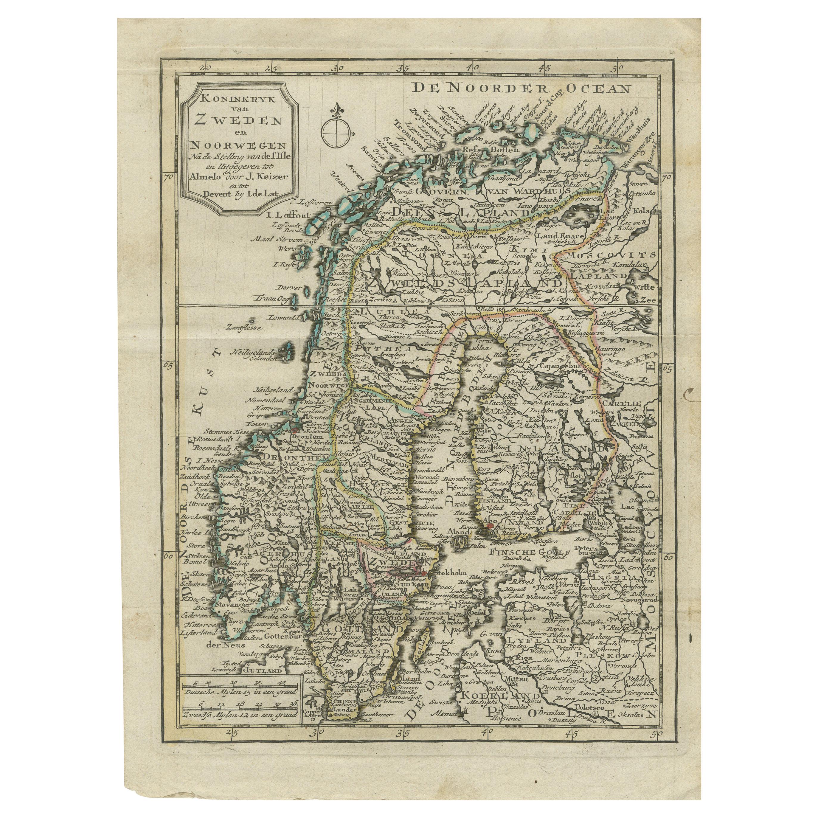
Antique Map of the Kingdom of Sweden and Norway by Keizer & de Lat, 1788
Located in Langweer, NL
Antique map titled 't Koninkryk van Zweden en Noorwegen'. Uncommon original antique map of the Kingdom of Sweden and Norway. This map originates from 'Nieuwe Natuur- Geschied- en Han...
Category
Antique Late 18th Century Maps
Materials
Paper
$330 Sale Price
20% Off
Antique Map of Sweden by Bowen, 1747
Located in Langweer, NL
Antique map titled 'A New & Accurate Map of Sweden'. This map covers Sweden and Finland (shown as part of Sweden) as well as parts of modern day Estonia,...
Category
Antique 18th Century Maps
Materials
Paper

$254 Sale Price
20% Off
Antique Map of Scandinavia by Lapie, 1842
Located in Langweer, NL
Antique map titled 'Carte de la Scandinavie comprenant les Royaumes de Suède de Norwege et de Danemark'. Map of Scandinavia including Sweden, Norway and Denma...
Category
Antique Mid-19th Century Maps
Materials
Paper

$519 Sale Price
20% Off
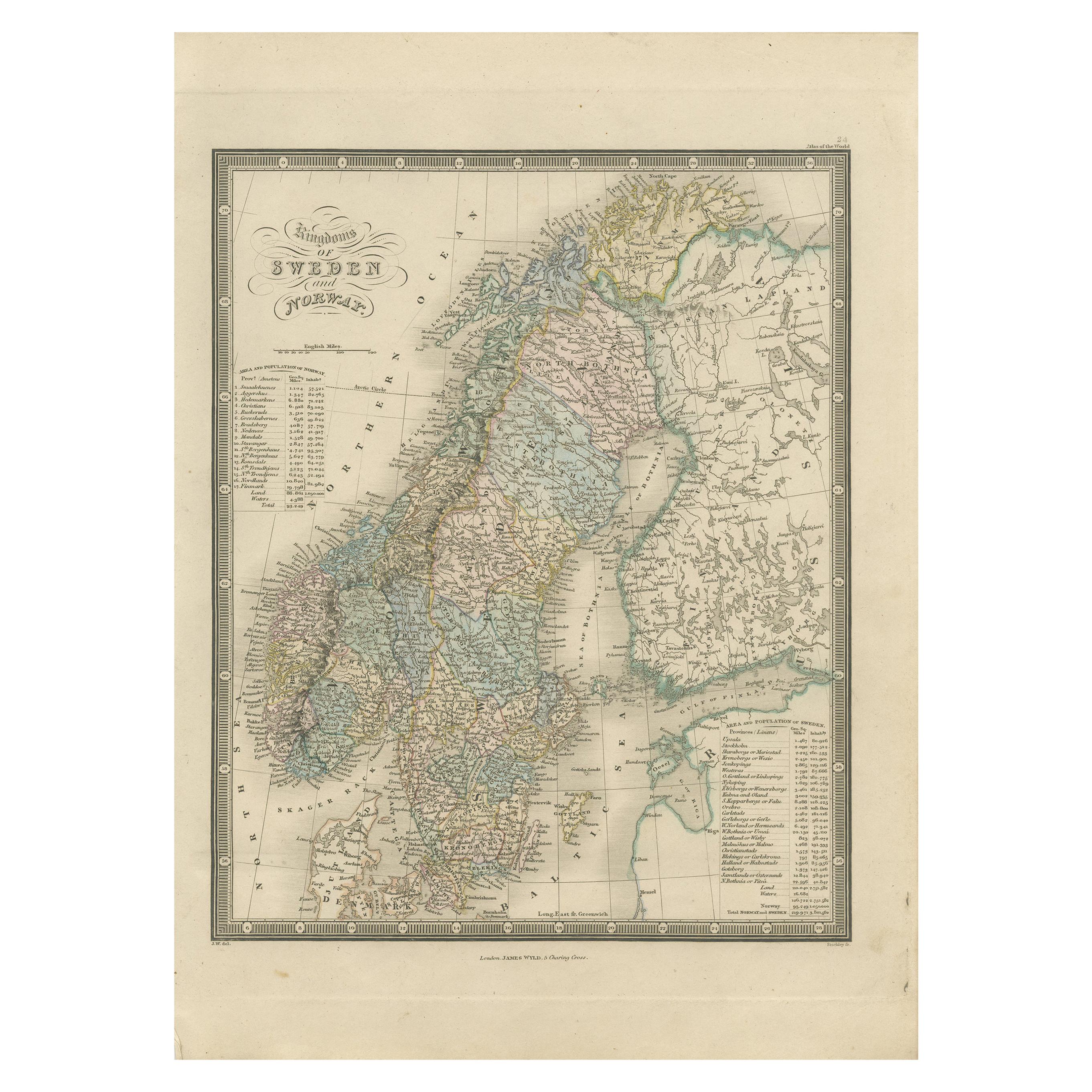
Antique Map of the Kingdoms of Sweden and Norway by Wyld '1845'
Located in Langweer, NL
Antique map titled 'Kingdoms of Sweden and Norway'. Original antique map of the Kingdoms of Sweden and Norway. This map originates from 'An Atlas of the World, Comprehending Separate...
Category
Antique Mid-19th Century Maps
Materials
Paper
$141 Sale Price
40% Off
Antique Map of Scandinavia by T. Jefferys, circa 1750
Located in Langweer, NL
Antique map titled 'Sweden, Denmark, Norway & Finland'. An original mid-18th century copper engraved antique map of Scandinavia by Thomas Jefferys....
Category
Antique Mid-18th Century Maps
Materials
Paper

$179 Sale Price
20% Off
You May Also Like
Original Antique Map of Sweden, Engraved by Barlow, 1806
Located in St Annes, Lancashire
Great map of Sweden
Copper-plate engraving by Barlow
Published by Brightly & Kinnersly, Bungay, Suffolk. 1806
Unframed.
Category
Antique Early 1800s English Maps
Materials
Paper

Sweden & Adjacent Portions of Scandinavia: A Hand-Colored 18th C. Map by Homann
By Johann Baptist Homann
Located in Alamo, CA
This hand-colored map of Sweden and adjacent portions of Scandinavia entitled "Regni Sueciae in Omnes suas Subjacentes Provincias accurate divisi Tabula Generalis" was created by Joh...
Category
Antique 1720s German Maps
Materials
Paper

Scandinavia & Portions of Eastern Europe: 18th Century Hand-Colored Homann Map
By Johann Baptist Homann
Located in Alamo, CA
An early 18th century hand-colored copper-plate map entitled "Regni Sueciae in omnes suas Subjacentes Provincias accurate divisi Tabula Generalis" by Johann Baptist Homann (1663-1724...
Category
Antique Early 18th Century German Maps
Materials
Paper

Sweden and Adjacent Portions of Scandinavia: A Hand-colored 18th C. Homann Map
By Johann Baptist Homann
Located in Alamo, CA
This hand-colored copper-plate map of Sweden and adjacent portions of Scandinavia entitled "Regni Sueciae in Omnes suas Subjacentes Provincias accurate divisi Tabula Generalis" was c...
Category
Early 18th Century Old Masters Landscape Prints
Materials
Engraving

Ancient Map of Denmark and Sweden - Original Etching - 19th Century
By Giuseppe Malandrino
Located in Roma, IT
This Map of Denmark and Sweden is an etching realized by an anonymous artist.
The state of preservation of the artwork is good with some small diffused stains.
Sheet dimension: 27x...
Category
Late 19th Century Modern Figurative Prints
Materials
Etching

Hand-Colored 18th Century Homann Map of Denmark and Islands in the Baltic Sea
By Johann Baptist Homann
Located in Alamo, CA
An 18th century copper plate hand-colored map entitled "Insulae Danicae in Mari Balthico Sitae utpote Zeelandia, Fionia, Langelandia, Lalandia, Falstria, Fembria Mona" created by Joh...
Category
Antique Early 18th Century German Maps
Materials
Paper

More Ways To Browse
Antique Furniture Dundee
Antique Saudi Arabia
Otto Petri
Serbia Antique Map
Taiwan Map
Antique Maps Colorado
Antique Wooden Roller
Hemisphere Antiques
Map Of Jamaica
Raleigh Antique Furniture
Antique Map Of Colombia
Antique Map Palestine
Vintage Wooden Roller
Antique Constellation Map
Antique Maps Of Cape Of Good Hope
Caucasus Map
Map Of Puerto Rico
Nevada Antique Map