Items Similar to Antique Map of Sweden and Norway by Russell, 1814


Want more images or videos?
Request additional images or videos from the seller
1 of 5
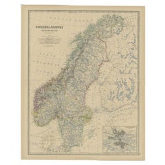
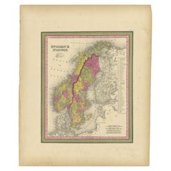
Antique Map of Sweden and Norway by Russell, 1814
About the Item
Antique map Scandinavia titled 'Sweden & Norway'. Antique map of Scandinavia with a focus on Sweden and Norway. Artists and Engravers: Engraved by Russell. Published by Nuttall, Fisher & Co, Liverpool.
Artist: Engraved by Russell. Published by Nuttall, Fisher & Co, Liverpool.
Condition: Good, age-related toning. Original, contemporary hand coloring. Please study image carefully.
Date: 1814
Overall size: 21 x 26 cm.
Image size: 0.001 x 18 x 23 cm.
Antique prints have long been appreciated for both their aesthetic and investment value. They were the product of engraved, etched or lithographed plates. These plates were handmade out of wood or metal, which required an incredible level of skill, patience and craftsmanship. Whether you have a house with Victorian furniture or more contemporary decor an old engraving can enhance your living space. We offer a wide range of authentic antique prints for any budget.
- Dimensions:Height: 10.24 in (26 cm)Width: 8.27 in (21 cm)Depth: 0 in (0.01 mm)
- Materials and Techniques:
- Period:
- Date of Manufacture:1814
- Condition:
- Seller Location:Langweer, NL
- Reference Number:
About the Seller
5.0
Platinum Seller
These expertly vetted sellers are 1stDibs' most experienced sellers and are rated highest by our customers.
Established in 2009
1stDibs seller since 2017
1,929 sales on 1stDibs
Typical response time: <1 hour
- ShippingRetrieving quote...Ships From: Langweer, Netherlands
- Return PolicyA return for this item may be initiated within 14 days of delivery.
More From This SellerView All
- Antique Map of Sweden and Norway by W. G. Blackie, 1859Located in Langweer, NLAntique map titled 'Sweden and Norway'. Original antique map of Sweden and Norway. This map originates from ‘The Imperial Atlas of Modern Geography’. Published by W. G. Blackie, 1859.Category
Antique Mid-19th Century Maps
MaterialsPaper
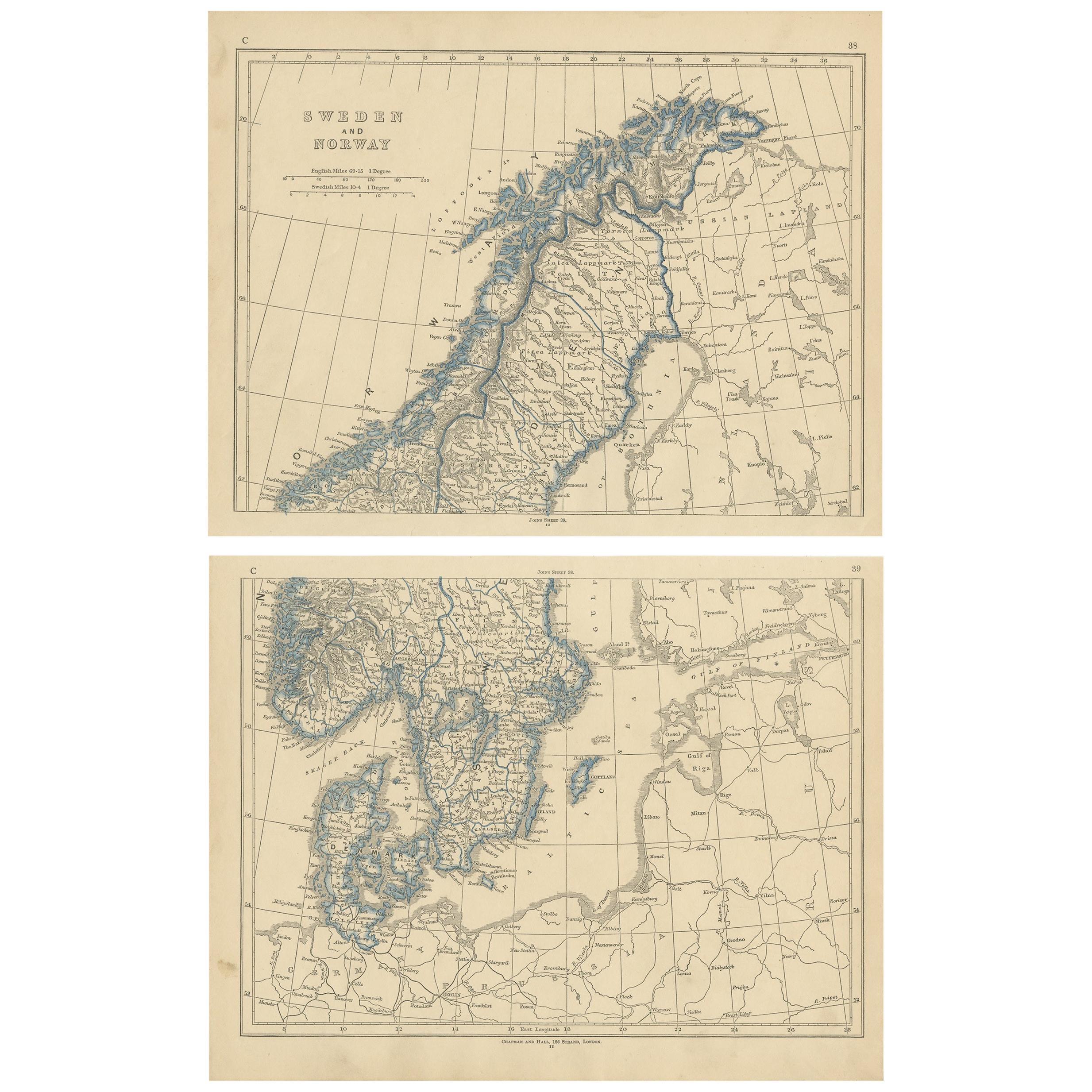
- Antique Map of Sweden and Norway by Lowry, '1852'Located in Langweer, NLAntique map titled 'Sweden and Norway'. Two individual sheets of Sweden and Norway. This map originates from 'Lowry's Table Atlas constructed and engraved from the most recent Author...Category
Antique Mid-19th Century Maps
MaterialsPaper
- Antique Map of Sweden and Norway by Petri, 1852Located in Langweer, NLAntique map titled 'Zweden en Noorwegen'. Map of Sweden and Norway. This map originates from 'School-Atlas van alle deelen der Aarde' by Otto Petri. Artists...Category
Antique 19th Century Maps
MaterialsPaper
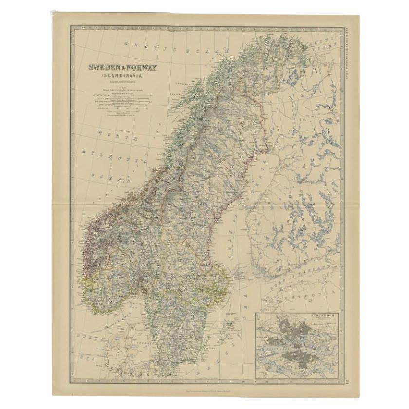
- Antique Map of Sweden and Norway by Johnston, 1882Located in Langweer, NLAntique map titled 'Sweden & Norway (Scandinavia)'. Old map of Sweden and Norway, with inset map of Stockholm. This map originates from 'The Royal Atlas ...Category
Antique 19th Century Maps
MaterialsPaper
- Antique Map of Sweden and Norway by Petri, c.1873Located in Langweer, NLAntique map titled 'Zweden en Noorwegen'. Old map depicting Sweden and Norway. This map originates from 'School-Atlas van alle Deelen der Aarde'. Artists and Engravers: Published by ...Category
Antique 19th Century Maps
MaterialsPaper
- Antique Map of Sweden and Norway by Mitchell, 1846Located in Langweer, NLAntique map titled 'Sweden & Norway'. Old map of Sweden and Norway. This map originates from 'A New Universal Atlas Containing Maps of the various Empires, Kingdoms, States and Repub...Category
Antique 19th Century Maps
MaterialsPaper


You May Also Like
- Original Antique Map of Sweden and Norway, Grattan and Gilbert, 1843Located in St Annes, LancashireGreat map of Sweden and Norway Drawn and engraved by Archer Published by Grattan and Gilbert Original color Unframed.Category
Antique 1840s English Other Maps
MaterialsPaper
- 1814 Map of "Russian Empire" Ric.r032Located in Norton, MA1814 Map of "Russian Empire" Ric.r032 Russian Empire. Description: This is an 1814 John Thomson map of the Russian Empire. The map depicts the region from the Baltic Sea, Prussia, and Sweden to the Aleutian Islands and from the Arctic Ocean to the Yellow River. Highly detailed, myriad cities, towns, and villages are labeled throughout, including St. Petersburg, Moscow, Minsk, Kiev, and Kharkov. Rivers and mountain ranges are also identified, as are islands and numerous locations along the coastlines. It is important to note that the long-disputed sea between Korea and Japan is identified as the 'Sea of Japan. Historical Context: In 1815, Tsarist Russia emerged from the Napoleonic Wars economically insolvent and politically fearful of the Revolutionary fervor that had just swept through Europe. In order to shore up Russia's economic position, the Tsars began an aggressive series of expansions into the Caucuses and Central Asia that would vastly increase the landmass of the Russian Empire. Publication History Thomson maps are known for their stunning color, awe inspiring size, and magnificent detail. Thomson's work, including this map, represents some of the finest cartographic art...Category
Antique 19th Century Unknown Maps
MaterialsPaper
- Original Antique Map of Sweden, Engraved by Barlow, 1806Located in St Annes, LancashireGreat map of Sweden Copper-plate engraving by Barlow Published by Brightly & Kinnersly, Bungay, Suffolk. 1806 Unframed.Category
Antique Early 1800s English Maps
MaterialsPaper
- 1861 Topographical Map of the District of Columbia, by Boschke, Antique MapLocated in Colorado Springs, COPresented is an original map of Albert Boschke's extremely sought-after "Topographical Map of the District of Columbia Surveyed in the Years 1856 ...Category
Antique 1860s American Historical Memorabilia
MaterialsPaper
- 1907 Map of Colorado, Antique Topographical Map, by Louis NellLocated in Colorado Springs, COThis highly detailed pocket map is a topographical map of the state of Colorado by Louis Nell from 1907. The map "has been complied from all availabl...Category
Antique Early 1900s American Maps
MaterialsPaper
- 1854 Map of Massachusetts, Connecticut and Rhode Island, Antique Wall MapLocated in Colorado Springs, COThis striking wall map was published in 1854 by Ensign, Bridgman & Fanning and has both full original hand-coloring and original hardware. This impression is both informative and highly decorative. The states are divided into counties, outlined in red, green, and black, and subdivided into towns. Roads, canals, and railroad lines are prominently depicted, although they are not all labeled. The mapmakers also marked lighthouses, banks, churches, and prominent buildings, with a key at right. The map is an informative and comprehensive overview of the infrastructural development of New England prior to the Civil War. Physical geographies depicted include elevation, conveyed with hachure marks, rivers and lakes. The impression features an inset map of Boston...Category
Antique 19th Century American Maps
MaterialsPaper


Recently Viewed
View AllMore Ways To Browse
Antique Furniture Liverpool
Antique Norwegian
Norwegian Antique
Antique Norwegian Furniture
Norwegian Antique Furniture
Russell Wood
19th Norwegian
Norway 19th Century
19th Century Norwegian
Liverpool Antiques
Norwegian Plates
Antique Norway
Artist Russell Wood
19th Century Norwegian Furniture
Antique Swedish Plates
Norway Plate
Scandinavia Antiques And Living
Antique Swedish Print