Items Similar to Antique Map of Northwest Italy by Cluver, 1685


Want more images or videos?
Request additional images or videos from the seller
1 of 5
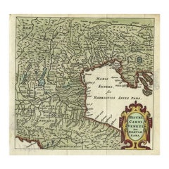
Antique Map of Northwest Italy by Cluver, 1685
$110.32
$137.9120% Off
£82.07
£102.5920% Off
€92
€11520% Off
CA$151.07
CA$188.8420% Off
A$167.97
A$209.9620% Off
CHF 87.71
CHF 109.6320% Off
MX$2,044.62
MX$2,555.7820% Off
NOK 1,119.08
NOK 1,398.8520% Off
SEK 1,048.53
SEK 1,310.6620% Off
DKK 700.35
DKK 875.4320% Off
Shipping
Retrieving quote...The 1stDibs Promise:
Authenticity Guarantee,
Money-Back Guarantee,
24-Hour Cancellation
About the Item
Antique map titled 'Ligures, Taurini, etc.' Miniature map of northwest Italy. From the pocket atlas 'Introductionis in Universam Geographiam tam Veterem quam novam .. Acessit P. Bertii (Bertius) Brevarium Orbis Terrarum', by Ph. Cluverius (Cluver). Artists and Engravers: Petrus Bertius (also Peter Bertius; (Dutch) Pieter de Bert) (14 November 1565 ? 13 October 1629) was a Flemish theologian, historian, geographer and cartographer. Philipp Cluver (1580 - 1622), early modern German geographer and historian.
Artist: Petrus Bertius (also Peter Bertius; (Dutch) Pieter de Bert) (14 November 1565 ? 13 October 1629) was a Flemish theologian, historian, geographer and cartographer. Philipp Cluver (1580 - 1622), early modern German geographer and historian.
Condition: Good, given age. Original folds as issued. General age-related toning and/or occasional minor defects from handling. Please study image carefully.
Date: 1685
Overall size: 14 x 13 cm.
Image size: 0.001 x 12.3 x 12 cm.
Antique prints have long been appreciated for both their aesthetic and investment value. They were the product of engraved, etched or lithographed plates. These plates were handmade out of wood or metal, which required an incredible level of skill, patience and craftsmanship. Whether you have a house with Victorian furniture or more contemporary decor an old engraving can enhance your living space. We offer a wide range of authentic antique prints for any budget.
- Dimensions:Height: 5.12 in (13 cm)Width: 5.52 in (14 cm)Depth: 0 in (0.01 mm)
- Materials and Techniques:
- Period:
- Date of Manufacture:1685
- Condition:
- Seller Location:Langweer, NL
- Reference Number:Seller: PCT-620401stDibs: LU3054327616352
About the Seller
5.0
Recognized Seller
These prestigious sellers are industry leaders and represent the highest echelon for item quality and design.
Platinum Seller
Premium sellers with a 4.7+ rating and 24-hour response times
Established in 2009
1stDibs seller since 2017
2,510 sales on 1stDibs
Typical response time: <1 hour
- ShippingRetrieving quote...Shipping from: Langweer, Netherlands
- Return Policy
Authenticity Guarantee
In the unlikely event there’s an issue with an item’s authenticity, contact us within 1 year for a full refund. DetailsMoney-Back Guarantee
If your item is not as described, is damaged in transit, or does not arrive, contact us within 7 days for a full refund. Details24-Hour Cancellation
You have a 24-hour grace period in which to reconsider your purchase, with no questions asked.Vetted Professional Sellers
Our world-class sellers must adhere to strict standards for service and quality, maintaining the integrity of our listings.Price-Match Guarantee
If you find that a seller listed the same item for a lower price elsewhere, we’ll match it.Trusted Global Delivery
Our best-in-class carrier network provides specialized shipping options worldwide, including custom delivery.More From This Seller
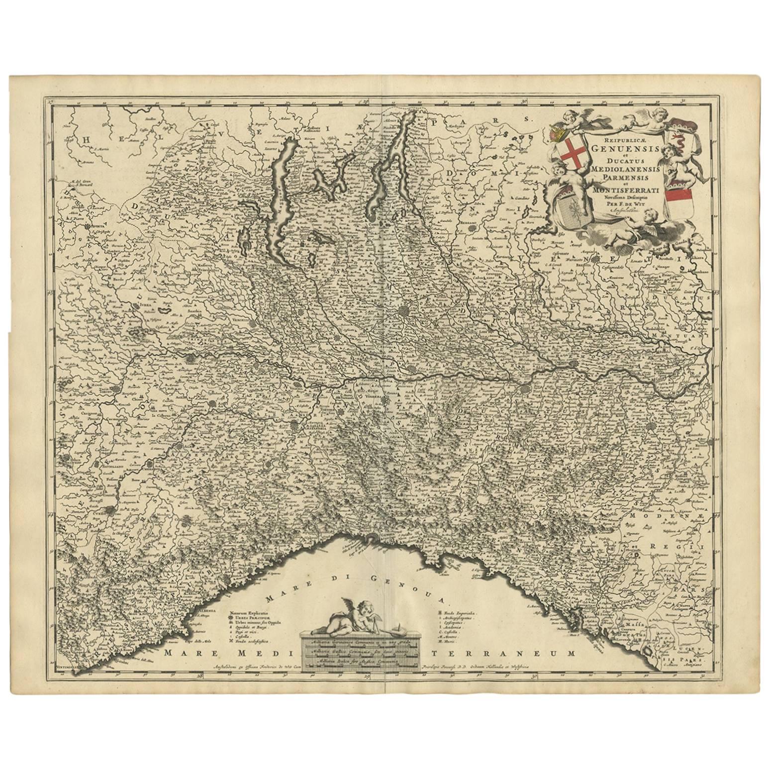
View AllAntique Map of Northern Italy by F. de Wit, 1690
Located in Langweer, NL
A very decorative map centered on Genua, and including the towns of Milan, Torino, Parma, Cremona, etc. Decorative title cartouche upper right, five putti holding the arms of the reg...
Category
Antique Late 17th Century Maps
Materials
Paper

$527 Sale Price
20% Off
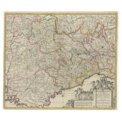
Antique Map of Northern Italy by Cluver, 1685
Located in Langweer, NL
Antique map titled 'Histri, Carni, Veneti item Rhaetiae Pars.' Charming miniature map of northern Italy with the Adriatic or upper sea, now called the Gulf of Venice, from the pocket...
Category
Antique 17th Century Maps
Materials
Paper
$191 Sale Price
20% Off
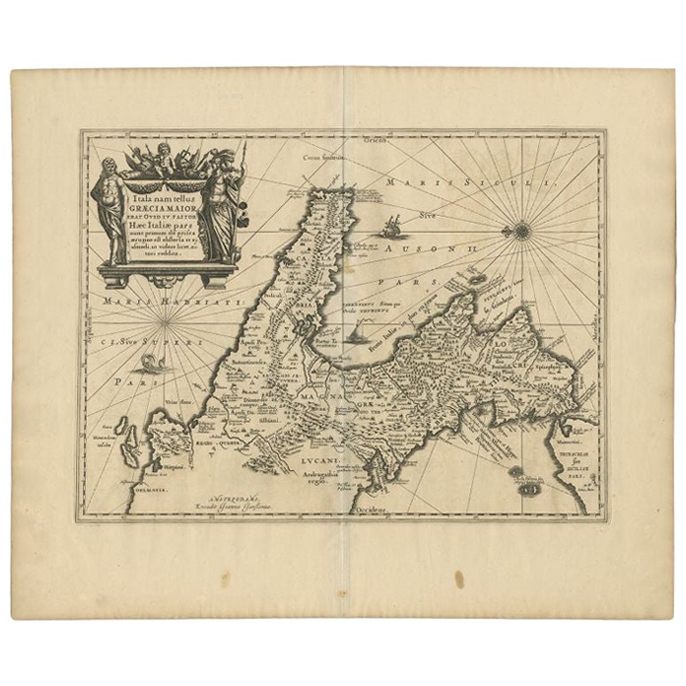
Antique Map of Southern Italy by Janssonius, C.1650
Located in Langweer, NL
"Antique map titled 'Itala nam tellus Graecia Maior erat Ovid. IV. Fastor. Haec Italiae pars nunc primum de prica aerugine est abstersa (..)'. Beautiful map of Southern Italy...
Category
Antique 17th Century Maps
Materials
Paper

$709 Sale Price
20% Off
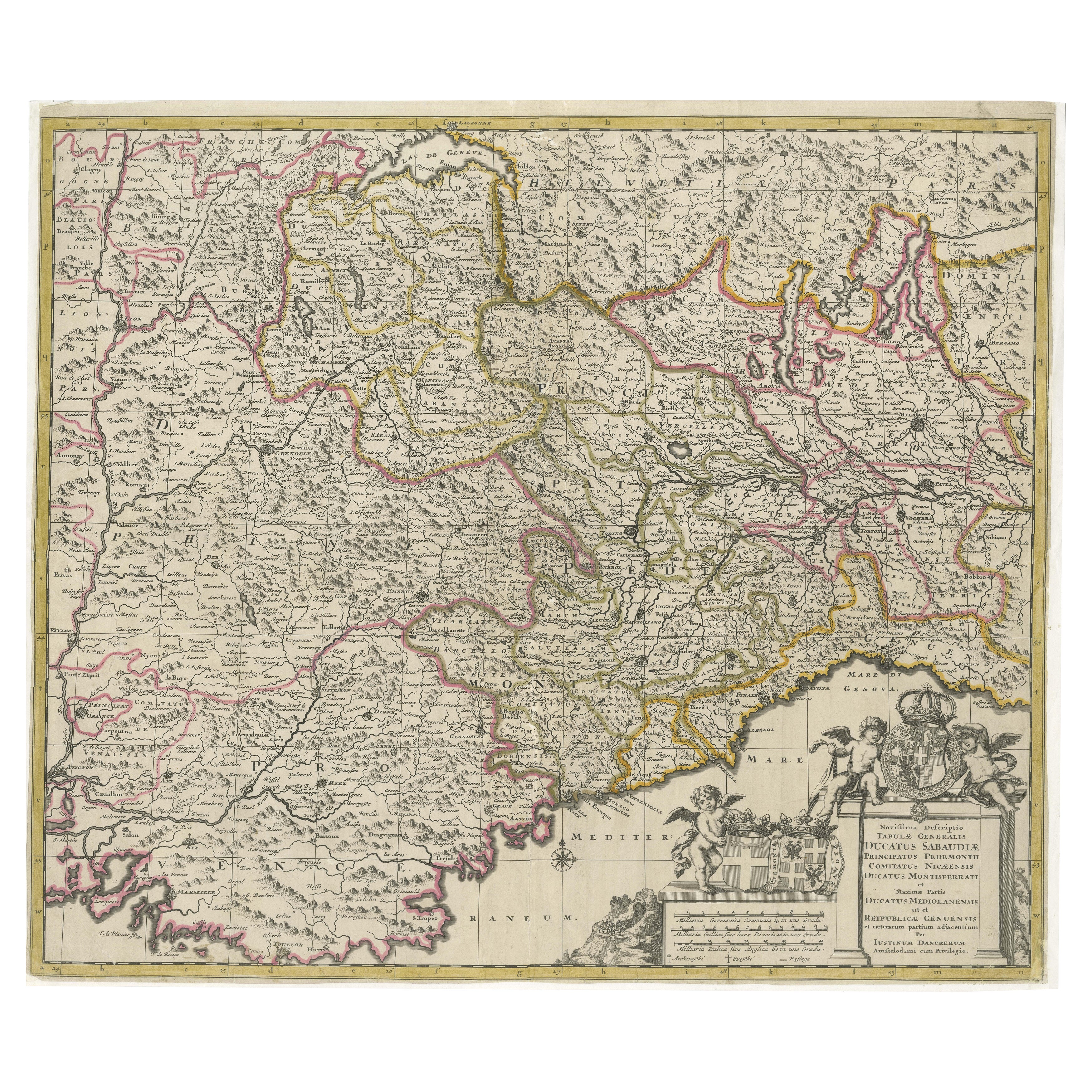
Antique Map of Piedmont, Savoy and Liguria by Justus Danckerts, Amsterdam c.1690
Located in Langweer, NL
Map of Piedmont, Savoy and Liguria by Justus Danckerts, Amsterdam c.1690
This richly detailed and decorative map, titled *Tabula Generalis Ducatus Sabaudiae Principatus Pedemontii C...
Category
Antique Late 17th Century Maps
Materials
Paper
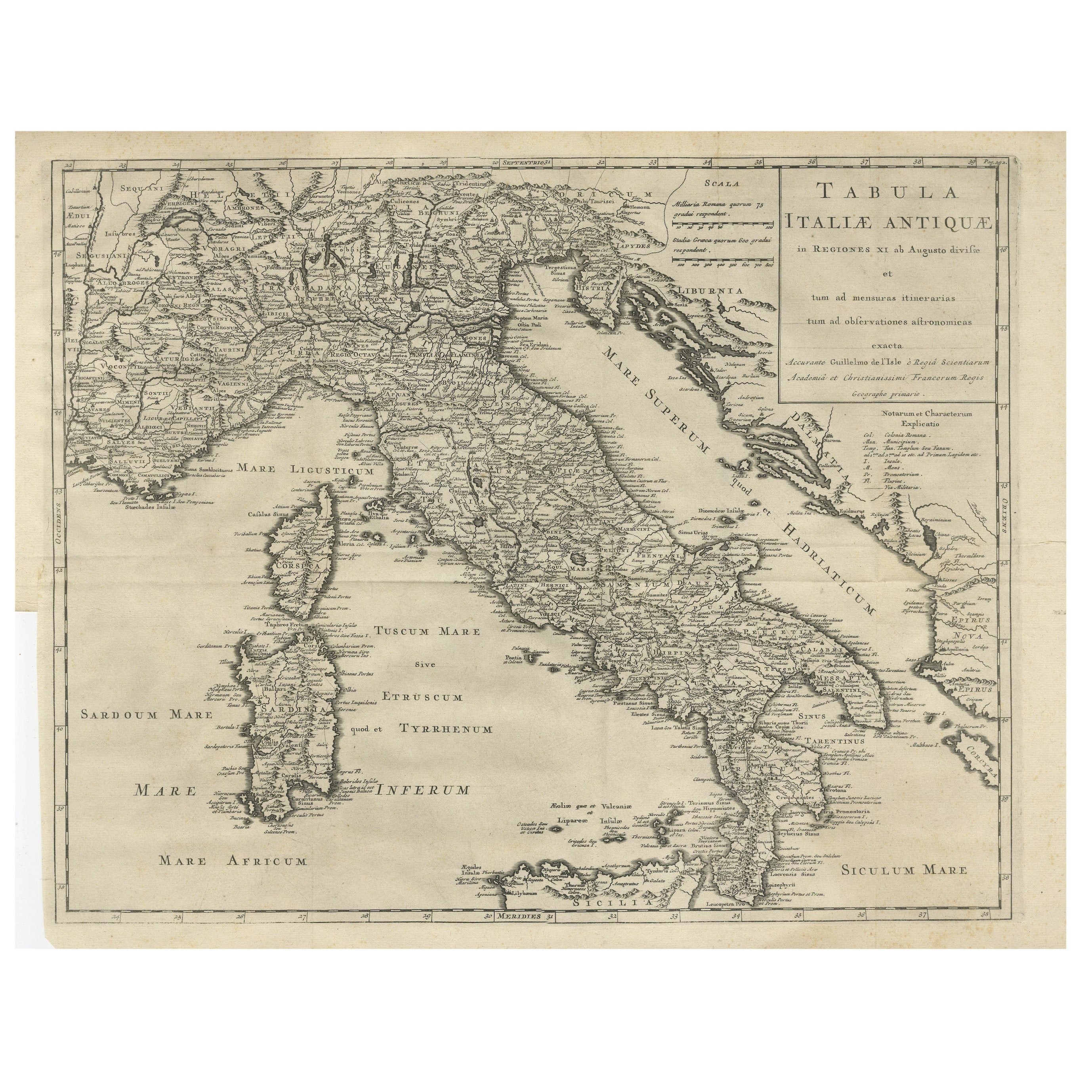
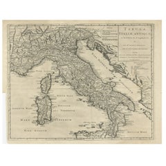
Antique Engraved Map of Italy in Roman Times, ca.1730
Located in Langweer, NL
Plain engr. map of Italy according to the division of Emperor Augustus by G. Delisle.
Title: "Tabula Italiae Antiquae In Regiones XI Ab Augusto Divisae Et Tum Ad Mensuras Itinerari...
Category
Antique 1730s Maps
Materials
Paper
$652 Sale Price
20% Off
Antique Map of the Region of Lyonnais by Janssonius, '1657'
By Johannes Janssonius
Located in Langweer, NL
Antique map 'Lionnois, forest, beauviolois et masconnois'. Decorative map of the Lyonnais region, France. The Lyonnais is a historical province of France which owes its name to the c...
Category
Antique Mid-17th Century Maps
Materials
Paper

$479 Sale Price
20% Off
You May Also Like
Li Governi di Borgogna - Ancient Map - 1777
Located in Roma, IT
Li Governi di Borgogna is an original black and white etching on paper, printed by Antonio Zatta in Venice, 1777.
Original Title: Li Governi di Borgogna della Franca Contea e del Ly...
Category
1770s Modern Landscape Prints
Materials
Etching

1640 Willem Blaeu Map Entitled "Contado di molise et principato vltra, " Ric.a003
By Willem Blaeu
Located in Norton, MA
1640 Willem Blaeu map entitled
"Contado di molise et principato vltra,"
Colored
Ric. a003
Measures: 38 x 49.6 cm and wide margins
DBLAEU.
Cou...
Category
Antique 17th Century Dutch Maps
Materials
Paper

Engraving Depicting 16th Century Map of Terra Sancta
Located in Buchanan, MI
Abraham Ortelius (Flemish, 1527-1598) Terra Sancta.
Engraving depicting 16th century map of Terra Sancta. Site 15" x 19.5.
Category
Antique 18th Century and Earlier Maps
Materials
Paper

Map of the Kingdom of Sardinia and Part of the Kingdom of Genoa, Rome
By Giovanni Maria Cassini
Located in Hamilton, Ontario
18th century map by Italian engraver Giovanni Maria Cassini (Italy 1745-1824). Map of Part of the Kingdom of Sardinia and Part of the Kingdom of Genoa: Rome. This is a hand colored a...
Category
Antique 18th Century Italian Maps
Materials
Paper

$795 Sale Price
36% Off
18th Century Map of the Southern Balkans by Giovanni Maria Cassini
By Giovanni Maria Cassini
Located in Hamilton, Ontario
18th century map by Italian engraver Giovanni Maria Cassini (Italy 1745-1824).
Map of the Southern Balkans: Rome. Hand colored and copper engraved print done in the year 1788. It in...
Category
Antique 18th Century Italian Maps
Materials
Paper

$795 Sale Price
36% Off
Large Original Antique Map of Italy. John Dower, 1861
Located in St Annes, Lancashire
Great map of Italy
Lithograph engraving by John Dower
Original colour
Published, 1861
Unframed
Good condition / repair to top right corner seen in last image
Category
Antique 1860s English Victorian Maps
Materials
Paper

More Ways To Browse
John Speed Maps
Antique Map Of Turkish Empire
Antique Portuguese Scales
Canadian Atlas Furniture
Prussia Map
Afghanistan Map
Malabar Map
Antique Compass Made In France
Antique Maps Dublin
Antique Newfoundland Canada
John Speed Antique Maps
Malaysia Map
Sebastian Munster
Antique Map Chile
Antique Map Of Boston
Ipswich Antique Furniture
Maps Balkans
Missouri Map