
John Speed Antique Maps

1
to
5
39
12
49
49
12
12
4
4
4
3
2
1
1
1
1
1
1
1
1
Sort By
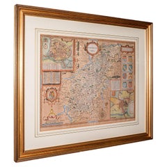
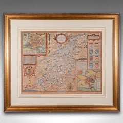
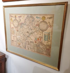
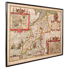
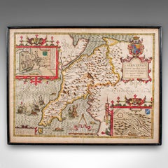
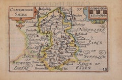
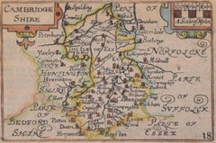
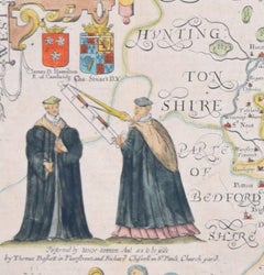
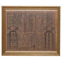
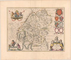
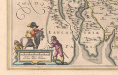
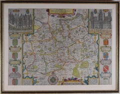
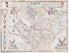
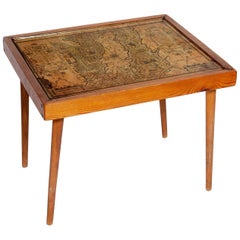
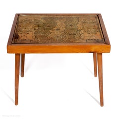
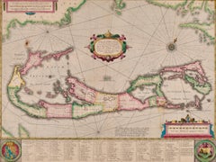
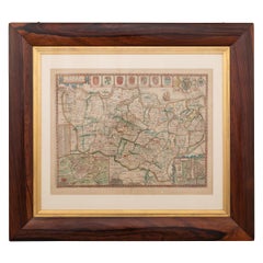
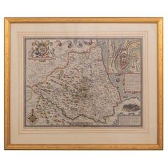
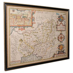
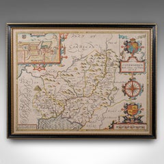
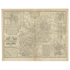
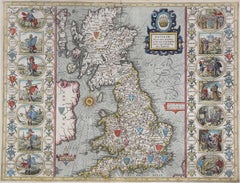
17th Century John Speed Map of Denbighshire, c.1610
By John Speed
Located in Royal Tunbridge Wells, Kent
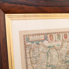
Antique early 17th century British very rare and original John Speed, hand coloured map of
Category

17th Century British John Speed Antique Maps

Materials

Wood, Paper

17th Century John Speed Map of the Barkshire Described, c.1616
By John Speed
Located in Royal Tunbridge Wells, Kent
Antique 17th century British very rare and original John Speed (1551-1629) map of the Barkshire
Category

17th Century British John Speed Antique Maps

Materials

Paper

Antique 17th Century John Speed Map of the Barkshire Described, c.1616
17th Century John Speed Map of the Barkshire Described, c.1616
Free Shipping
H 22.05 in W 26.38 in D 1.19 in
17th Century John Speed Map of Kent with Her Cities & Earles Described, C.1676
By John Speed
Located in Royal Tunbridge Wells, Kent
Antique 17th century British very rare and original John Speed (1551-1629) map of Kent with her
Category

17th Century British John Speed Antique Maps

Materials

Paper

17th Century Map of Cumberland County in Northwest England Printed by John Speed
By John Speed
Located in Middleburg, VA
Rare extremely early map of the county of Cumberland in the Northwest of England. Printed by John
Category

Early 17th Century English John Speed Antique Maps

Materials

Paper

Antique Map of Gloucestershire by John Speed, '1676'
Located in Langweer, NL
England, by John Speed. With inset town plans of Gloucester and Bristol. Published by Thomas Bassett
Category

Mid-17th Century John Speed Antique Maps

Materials

Paper

Road Map, John Ogilby, No 54, London, Yarmouth, Britannia
By John Ogilby
Located in BUNGAY, SUFFOLK
Bassett and Richard Chiswell to their edition of John Speed's 'Theatre of the Empire of Great Britain
Category

1670s English Baroque John Speed Antique Maps

Materials

Paper

Antique Map of Northamptonshire by Speed, 1676
Located in Langweer, NL
Peterborough and Northampton. This map originates from 'Theatre of Great Britaine' by John Speed. Artists and
Category

17th Century John Speed Antique Maps

Materials

Paper

Antique Map of Nottinghamshire by Speed, 1676
Located in Langweer, NL
inset town plan of Nottingham. This map originates from 'Theatre of Great Britaine' by John Speed
Category

17th Century John Speed Antique Maps

Materials

Paper

Antique Map of Surrey by Speed, 1676
Located in Langweer, NL
' by John Speed. Artists and Engravers: John Speed (1551 or 1552 ? 28 July 1629) was an English
Category

17th Century John Speed Antique Maps

Materials

Paper

Antique Map of Surrey by Speed, 1676
H 16.34 in W 21.26 in D 0 in
Antique Map of Warwickshire by Speed, c.1614
Located in Langweer, NL
plans of Warwick and Coventry. This map originates from 'Theatre of Great Britaine' by John Speed
Category

17th Century John Speed Antique Maps

Materials

Paper

Antique Map of Warwickshire by Speed, c.1614
No Reserve
H 14.97 in W 19.69 in D 0 in
Map Road Strip Britannia Sheet 2 John Ogilby London Aberistwith Islip Bramyard
By John Ogilby
Located in BUNGAY, SUFFOLK
framer, print seller, Oxford. Annotated. The second of 100 sheets of strip maps made for John Ogilby
Category

17th Century English Baroque John Speed Antique Maps

Materials

Paper

Map Road John Ogilby Britannia No 74 Ipswich to Norwich Cromer Framed
By John Ogilby
Located in BUNGAY, SUFFOLK
schematic diagrams added by Thomas Bassett and Richard Chiswell to their edition of John Speed's 'Theatre of
Category

1670s English Baroque John Speed Antique Maps

Materials

Paper

Road Map John Ogilby No 75 Kings Lyn Harwich, Britannia Framed Wallhanging
By John Ogilby
Located in BUNGAY, SUFFOLK
Bassett and Richard Chiswell to their edition of John Speed's 'Theatre of the Empire of Great Britain
Category

1670s European Baroque John Speed Antique Maps

Materials

Paper

Cambridge map 17th century engraving after John Speed
By John Speed
Located in London, GB
." Pieter van den Keere (1571 - circa 1646) after John Speed (1551 or 1552 - 1629) Map of Cambridgeshire
Category

1620s John Speed Antique Maps

Materials

Engraving

Cambridgeshire map 17th century engraving by John Speed
By John Speed
Located in London, GB
." John Speed (1551 or 1552 - 1629) Map of Cambridgeshire Engraving with later hand colouring 39 x 53 cm
Category

1610s John Speed Antique Maps

Materials

Engraving

Antique Map of Hertfordshire in England by Speed, 1627
Located in Langweer, NL
. This map originates from 'Theatre of Great Britaine' by John Speed. Artist: John Speed (1551 or
Category

17th Century John Speed Antique Maps

Materials

Paper

Road Map No43 London to Kings Lynn, Royston to Downham, John Ogilby, Britannia
By John Ogilby
Located in BUNGAY, SUFFOLK
John Ogilby (British 1600-1676) Cosmographer and Geographick Printer to Charles II. A road map
Category

Late 17th Century British Charles II John Speed Antique Maps

Materials

Paper

Road Map John Ogilby London St David's Britannia No 15 Abingdon Monmouth Framed
By John Ogilby
Located in BUNGAY, SUFFOLK
John Ogilby (British 1600-1676) Cosmographer and Geographick Printer to Charles II. A road map from
Category

1670s English Baroque John Speed Antique Maps

Materials

Paper

Road Map Britannia No 32 the Road from London to Barnstable John Ogilby Framed
By John Ogilby
Located in BUNGAY, SUFFOLK
A road map from Britannia, by John Ogilby Esq., Cosmographer and Geographick Printer to Charles II
Category

Late 17th Century English Charles II John Speed Antique Maps

Materials

Paper

Road Map Britannia No 15 London to St Davids John Ogilby Brown Gilt Frame
By John Ogilby
Located in BUNGAY, SUFFOLK
edition of John Speed's 'Theatre of the Empire of Great Britain', published in 1676. In private
Category

Late 17th Century British Charles II John Speed Antique Maps

Materials

Paper

Antique Map of Warwickshire in England by Speed, c.1614
Located in Langweer, NL
Great Britaine' by John Speed. Artists and Engravers: John Speed (1551 or 1552 – 28 July 1629) was an
Category

17th Century John Speed Antique Maps

Materials

Paper

Road Map Britannia No 25 London to the Lands End, John Ogilby Brown Gilded Frame
By John Ogilby
Located in BUNGAY, SUFFOLK
Senan in Cornwall. By John Ogilby His Majesties Cosmographer. A road map from Britannia, 1675/6. No 25
Category

Late 17th Century British Charles II John Speed Antique Maps

Materials

Paper

Buckingham Both Shyre and Shire John Speed 1610 Gilded Frame
Located in BUNGAY, SUFFOLK
Just purchased more information to follow. In unrestored condition, the sheet can be cleaned.
Category

17th Century English Baroque John Speed Antique Maps

Materials

Paper

Road Map Britannia 1675/6 No 5 Road London to Barwick, London Stilton Grey Frame
By John Ogilby
Located in BUNGAY, SUFFOLK
John Ogilby (British 1600-1676) cosmographer and geographick printer to Charles II. A road map from
Category

Late 17th Century British Charles II John Speed Antique Maps

Materials

Paper

John Speede Map The Countye of Monmouth
By John Speed
Located in London, GB
cannot find the view you want. John Speed/Speede (1551/2-1629) The Countye of Monmouthshire Performed by
Category

17th Century Realist John Speed Antique Maps

Materials

Engraving

Map of Warwickshire, England, Incl insets of Warwick and Coventry, c.1614
Located in Langweer, NL
Great Britaine' by John Speed. Artists and Engravers: John Speed (1551 or 1552 – 28 July 1629) was an
Category

1610s John Speed Antique Maps

Materials

Paper

Antique Map of Kent with Inset Plans of Rochester & Canterbury, England, 1676
Located in Langweer, NL
' by John Speed. Artists and Engravers: John Speed (1551 or 1552 ? 28 July 1629) was an English
Category

17th Century John Speed Antique Maps

Materials

Paper

Antique Map of the Provinces of Gelderland and Overijssel by Kaerius, 1617
Located in Langweer, NL
was published (known also as miniature Speeds because of the verso text copied from John Speed
Category

17th Century John Speed Antique Maps

Materials

Paper

North & South America: A 17th Century Hand-colored Map by Jansson & Goos
By Johannes Janssonius
Located in Alamo, CA
work was on maps created by Joannes Jansson, Jocodus Hondius, and John Speed.
Category

1620s Dutch John Speed Antique Maps

Materials

Paper

Stunning Decorative Antique Map of East Frisia with an Inset of Emden, c.1610
Located in Langweer, NL
orientation he moved to London where he worked with John Speed. As brother-in-law to famous Jodocus Hondius
Category

1610s John Speed Antique Maps

Materials

Paper

John Speede Map The Countye Palatine of Chester with that most ancient citie
By John Speed
Located in London, GB
cannot find the view you want. John Speed/Speede (1551/2-1629) The Countye Palatine of Chester with that
Category

17th Century Realist John Speed Antique Maps

Materials

Engraving

Table Low Sofa Vintage 1950s Map Isle of Man John Speed 1610 Thomas Durham 1595
Located in BUNGAY, SUFFOLK
collection of 67 maps prepared by John Speed of the ‘best known and most popular of English county maps
Category

1610s English Mid-Century Modern John Speed Antique Maps

Materials

Paper

AMERICA
By John Speed
Located in Santa Monica, CA
IMPORTANT AMERICAN MAP - ONE OF THE FIRST TO SHOW CALIFORNIA as an ISLAND JOHN SPEED (1552-1629
Category

1620s Old Masters John Speed Antique Maps

Materials

Engraving

AMERICA
AMERICA
H 15.125 in W 20.5 in
Bermuda: An Early 17th Century Hand-colored Map by Henricus Hondius
By Henricus Hondius
Located in Alamo, CA
earlier maps by John Speed in 1627. Henricus's older brother, Jodocus Hondius II, engraved a version of
Category

Early 17th Century Old Masters John Speed Antique Maps

Materials

Engraving

North & South America: A 17th Century Hand-colored Map by Jansson & Goos
By Johannes Jansson
Located in Alamo, CA
was on maps created by Joannes Jansson, Jocodus Hondius, and John Speed.
Category

1620s John Speed Antique Maps

Materials

Engraving

Strawberries Strewn on a Forest Floor
By William Mason Brown
Located in New York, NY
1865 to 1886. Brown was undoubtedly exposed to the teachings of John Ruskin, which so greatly affected
Category

19th Century American Realist John Speed Antique Maps

Materials

Canvas, Oil

Antique map of Antwerp and river Schelde by van der Keere - Engraving - 17th c.
Located in Zeeland, Noord-Brabant
he worked with John Speed. As brother-in-law to famous Jodocus Hondius (who had also fled to London
Category

1690s Old Masters John Speed Antique Maps

Materials

Engraving

17th Century John Speed Map Of The Bishoprick & Citie Of Durham, c.1611
By John Speed
Located in Royal Tunbridge Wells, Kent
Antique 17th century British very rare and original John Speed (1551-1629) map of the Bishoprick
Category

17th Century British John Speed Antique Maps

Materials

Paper

Antique Map of the East Indies by Speed '1676'
Located in Langweer, NL
Antique map titled 'A New Map of East India'. John Speed's map of Southeast Asia, China, Taiwan and
Category

Mid-17th Century John Speed Antique Maps

Materials

Paper

Antique Map of the East Indies by Speed '1676'
H 17.33 in W 22.45 in D 0.02 in
Collection of 12 Early Framed Maps Mostly by John Speed
Located in Essex, MA
In a variety of conditions. John Speed is known as Englands most famous Stuart mapmaker.
Category

17th Century English John Speed Antique Maps

Antique Map of Surrey by Speed, 1676
Located in Langweer, NL
' by John Speed. Artists and Engravers: John Speed (1551 or 1552 ? 28 July 1629) was an English
Category

17th Century John Speed Antique Maps

Materials

Paper

Antique Map of Surrey by Speed, 1676
H 16.34 in W 21.26 in D 0 in
Florida and Virginia: A 17th Century Hand-colored Map by Hondius after Mercator
By Gerard Mercator
Located in Alamo, CA
for John Speed’s famous Theatre of the Empire of Great Britaine. One of Hondius’ most successful
Category

Early 17th Century Dutch John Speed Antique Maps

Materials

Paper

17th Century Robert Morden Map of Britannia Romana, C.1695
By Robert Morden
Located in Royal Tunbridge Wells, Kent
instrument maker from England. Along with Emanuel Bowen, John Cary and John Speed, Robert Morden contributed
Category

17th Century British John Speed Antique Maps

Materials

Wood, Paper

1870s Theodolite Troughton & Simms Antique Scientific Instrument of Measurement
Located in Milan, IT
established itself as one of the best in the country. The company was owned by two brothers, Edward and John
Category

1870s John Speed Antique Maps

Materials

Brass

Road Map, from London to Kings Lynn, Royston to Downham, John Ogilby, Britannia
By John Ogilby
Located in BUNGAY, SUFFOLK
John Ogilby (British 1600-1676) Cosmographer and Geographick Printer to Charles II A road map
Category

Late 17th Century British Charles II John Speed Antique Maps

Materials

Paper

Antique Map of Bermuda by Hondius, 'circa 1630'
Located in Langweer, NL
Bermuda, with decorative cartouche, compass rose, and other embellishments. The map is based upon John
Category

Mid-17th Century John Speed Antique Maps

Materials

Paper

Antique Map of Hampshire with Inset Town Plan of Winchester, England, c.1614
Located in Langweer, NL
town plan of Winchester. This map originates from 'Theatre of Great Britaine' by John Speed. Artists
Category

17th Century John Speed Antique Maps

Materials

Paper

Framed Map of the British Isles by John Speed
Located in Essex, MA
Engraved by Jodocus Hondius for John Speeds, 'Theatre Of The Empire Of Great Britain' and published
Category

17th Century John Speed Antique Maps

Florida and Virginia: A 17th Century Hand-colored Map by Hondius after Mercator
By Gerard Mercator
Located in Alamo, CA
for John Speed’s famous Theatre of the Empire of Great Britaine. One of Hondius’ most successful
Category

Early 17th Century John Speed Antique Maps

Materials

Engraving

Framed Hand Colored Map of Persia by John Speed
Located in Essex, MA
Framed hand colored map of Persia by John Speed. Nicely matted.
Category

Late 17th Century English John Speed Antique Maps

Materials

Other

Rare 17th Cenury Hand Colored “Mappa Aestivarum Insularum Alias Barmudas”
Located in Gallatin, TN
his work on John Speed’s remarkably accurate map of 1626-1627. It shows the island divided into tribes
Category

17th Century John Speed Antique Maps

Materials

Laid Paper, Color Pencil

Get Updated with New Arrivals
Save "John Speed Antique Maps", and we’ll notify you when there are new listings in this category.

John Speed Antique Maps For Sale on 1stDibs

At 1stDibs, there are several options of john speed antique maps available for sale. The range of distinct john speed antique maps — often made from paper, metal and other — can elevate any home. John speed antique maps have been produced for many years, with earlier versions available from the 17th Century and newer variations made as recently as the 18th Century. Mid-Century Modern john speed antique maps are consistently popular styles.

How Much are John Speed Antique Maps?

Prices for john speed antique maps start at $557 and top out at $7,500 with the average selling for $1,699.

Read More

Pamela Shamshiri Shares the Secrets behind Her First-Ever Book and Its Effortlessly Cool Interiors

The sought-after designer worked with the team at Hoffman Creative to produce a monograph that beautifully showcases some of Studio Shamshiri's most inspiring projects.

Moroccan Artworks and Objects Take Center Stage in an Extraordinary Villa in Tangier

Italian writer and collector Umberto Pasti opens the doors to his remarkable cave of wonders in North Africa.

Montecito Has Drawn Royalty and Celebrities, and These Homes Are Proof of Its Allure

Hollywood A-listers, ex-pat aristocrats and art collectors and style setters of all stripes appreciate the allure of the coastal California hamlet — much on our minds after recent winter floods.

Whaam! Blam! Pow! — a New Book on Pop Art Packs a Punch

Publishing house Assouline and writer Julie Belcove have teamed up to trace the history of the genre, from Roy Lichtenstein, Andy Warhol and Yayoi Kusama to Mickalene Thomas and Jeff Koons.

The Sparkling Legacy of Tiffany & Co. Explained, One Jewel at a Time

A gorgeous new book celebrates — and memorializes — the iconic jeweler’s rich heritage.

What Makes a Gem-Encrusted Chess Set Worth $4 Million?

The world’s most opulent chess set, weighing in at 513 carats, is literally fit for a king and queen.

Tauba Auerbach’s Geometric Pop-Up Book Is Mighty Rare, Thanks to a Hurricane

This sculptural art book has an epic backstory of its own.

Step inside the Storied Mansions of Palm Beach’s Most Effervescent Architect

From Spanish-style courtyards to fanciful fountains, these acclaimed structures abound in surprising and elegant details.