Items Similar to Antique Map of Kent with Inset Plans of Rochester & Canterbury, England, 1676


Want more images or videos?
Request additional images or videos from the seller
1 of 5
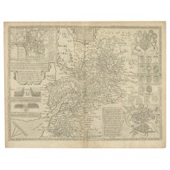
Antique Map of Kent with Inset Plans of Rochester & Canterbury, England, 1676
About the Item
Antique map titled 'Kent with her Cities and Earles described and observed'.
Map of Kent, England. Includes inset town plans of Rochester and Canterbury. This map originates from 'Theatre of Great Britaine' by John Speed. Artists and Engravers: John Speed (1551 or 1552 ? 28 July 1629) was an English cartographer and historian. He is, alongside Christopher Saxton, one of the best known English mapmakers of the early modern period.
Artist: John Speed (1551 or 1552 ? 28 July 1629) was an English cartographer and historian. He is, alongside Christopher Saxton, one of the best known English mapmakers of the early modern period.
Condition: Fair, general age-related toning. Repair on folding line. Few small defects and holes, also affecting image. Minor wear and soiling, English text on verso. Please study image carefully.
Date: 1676
Overall size: 52 x 40 cm.
Image size: 50 x 38.5 cm.
- Dimensions:Height: 20.48 in (52 cm)Width: 15.75 in (40 cm)Depth: 0 in (0.01 mm)
- Materials and Techniques:
- Period:
- Date of Manufacture:1676
- Condition:Condition: Fair, general age-related toning. Repair on folding line. Few small defects and holes, also affecting image. Minor wear and soiling, English text on verso. Please study image carefully.
- Seller Location:Langweer, NL
- Reference Number:
About the Seller
5.0
Platinum Seller
These expertly vetted sellers are 1stDibs' most experienced sellers and are rated highest by our customers.
Established in 2009
1stDibs seller since 2017
1,928 sales on 1stDibs
Typical response time: <1 hour
- ShippingRetrieving quote...Ships From: Langweer, Netherlands
- Return PolicyA return for this item may be initiated within 14 days of delivery.
More From This SellerView All
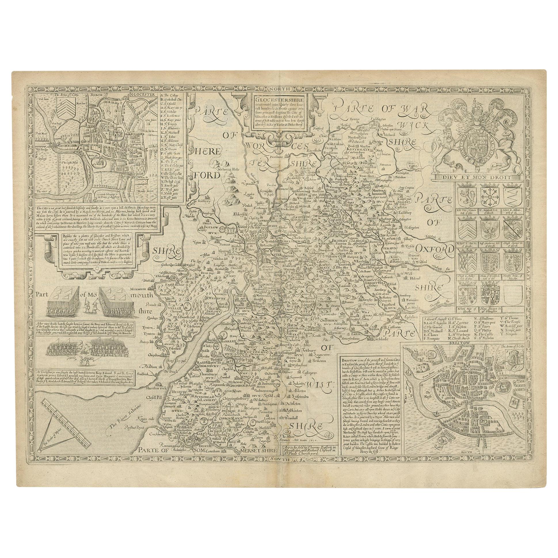
- Antique Map of Gloucestershire by John Speed, '1676'Located in Langweer, NLAntique map titled 'Glocestershire'. Original 17th century map of Gloucestershire, South West England, by John Speed. With inset town plans of G...Category
Antique Mid-17th Century Maps
MaterialsPaper
- Antique Map of Wisconsin with Inset Geological Map of WisconsinLocated in Langweer, NLAntique map titled 'Wisconsin'. Original antique map of Wisconsin, United States. With inset geological map of Wisconsin. This print originates from '...Category
Antique Late 19th Century Maps
MaterialsPaper
- Antique Map of Denmark with an Inset Map of Iceland, 1832Located in Langweer, NLAntique map titled 'Denmark'. Large map of Denmark with an inset map of Iceland. Artists and Engravers: Published by J. Arrowsmith in London, 1832. Condition: Good, general age...Category
Antique 19th Century Maps
MaterialsPaper
- Antique Map of Greece with an Inset Map of Corfu, 1854Located in Langweer, NLAntique map titled 'Hellas or Greece'. Old map of Greece with an inset map of Corfu. This map orginates from 'General Atlas Of The World: Containing Upwards Of Seventy Maps (..)' by ...Category
Antique 19th Century Maps
MaterialsPaper
- Antique Map of Eastern Canada with an inset Map of Newfoundland, 1882Located in Langweer, NLAntique map titled 'Dominion of Canada'. Old map of Eastern Canada with an inset map of Newfoundland. This map originates from 'The Royal Atlas of Modern Geography, Exhibiting, in a ...Category
Antique 19th Century Maps
MaterialsPaper
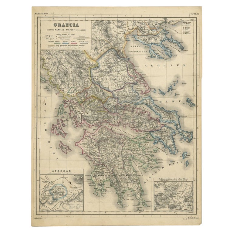
- Antique Map of Greece with Two Small Inset Maps of Athens, c.1870Located in Langweer, NLAntique map titled 'Graecia'. Old map of Greece with two small inset maps of Athens. This map originates from 'Atlas Antiquus, twaalf kaarten behoorende bij de Oude Geschiedenis'. Ar...Category
Antique 19th Century Maps
MaterialsPaper


You May Also Like
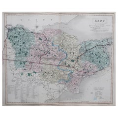
- Original Antique English County Map, Kent. J & C Walker, 1851Located in St Annes, LancashireGreat map of Kent Original colour By J & C Walker Published by Longman, Rees, Orme, Brown & Co. 1851 Unframed.Category
Antique 1850s English Other Maps
MaterialsPaper
- Old Horizontal Map of EnglandBy TassoLocated in Alessandria, PiemonteST/520 - Old rare Italian map of England, dated 1826-1827 - by Girolamo Tasso, editor in Venise, for the atlas of M.r Le-Sage.Category
Antique Early 19th Century Italian Other Prints
MaterialsPaper
- Original Antique Map / City Plan of Brussels by Tallis, circa 1850Located in St Annes, LancashireGreat map of Brussels. Steel engraving. Published by London Printing & Publishing Co. (Formerly Tallis), C.1850 Free shipping.Category
Antique 1850s English Maps
MaterialsPaper
- Antique Map of Principality of MonacoBy Antonio Vallardi EditoreLocated in Alessandria, PiemonteST/619 - "Old Geographical Atlas of Italy - Topographic map of ex-Principality of Monaco" - ediz Vallardi - Milano - A somewhat special edition ---Category
Antique Late 19th Century Italian Other Prints
MaterialsPaper
- Original Antique Map of Italy. C.1780Located in St Annes, LancashireGreat map of Italy Copper-plate engraving Published C.1780 Unframed.Category
Antique Early 1800s English Georgian Maps
MaterialsPaper

- Original Antique Map of Asia. C.1780Located in St Annes, LancashireGreat map of Asia Copper-plate engraving Published C.1780 Two small worm holes to right side of map Unframed.Category
Antique Early 1800s English Georgian Maps
MaterialsPaper


Recently Viewed
View AllMore Ways To Browse
Antique Plan
Antique Plans
Antique Fairs England
Antique Kent
Used Furniture Rochester
Antique Furniture Kent
Antique City Plans
John Speed
English Canterbury
Antique Canterburys
Canterbury Used Furniture And Antiques
Rochester Used Office Furniture
Antique Furniture Rochester
Speed Map
Map Of Kent
John Speed Map
John Speed Antique Maps
John Speed Maps