Items Similar to Antique Map of Persia and Afghanistan, 1903, with Delicate Pastel Borders


Want more images or videos?
Request additional images or videos from the seller
1 of 10
Antique Map of Persia and Afghanistan, 1903, with Delicate Pastel Borders
$383.17
£283.24
€320
CA$521.13
A$583.93
CHF 303.96
MX$7,143.45
NOK 3,858.16
SEK 3,643.99
DKK 2,436.64
Shipping
Retrieving quote...The 1stDibs Promise:
Authenticity Guarantee,
Money-Back Guarantee,
24-Hour Cancellation
About the Item
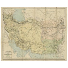
Title: Antique Map of Persia and Afghanistan, 1903, with Delicate Pastel Borders and Detailed Topography
Description:
This antique map, titled "Persia and Afghanistan," was engraved and published in 1903 by W. & A.K. Johnston in Edinburgh and London. It offers a highly detailed and beautifully crafted depiction of two regions that have long been at the center of trade, culture, and political intrigue in Central Asia.
Hand-colored in soft pastel shades of green, pink, yellow, and blue, the map delineates provincial and national boundaries with elegant clarity. Major cities, including Tehran, Kabul, Herat, and Kandahar, are clearly marked, along with key mountain ranges, river systems, and desert regions. The map’s delicate typography and precise engraving highlight the rugged beauty and strategic importance of these lands.
Of particular interest is the map’s depiction of the Caspian Sea, the Persian Gulf, and the Arabian Sea, emphasizing the maritime and economic connections that linked Persia and Afghanistan to neighboring empires and beyond. The vast and often harsh landscapes of these regions are captured with a sense of both artistry and scientific precision, reflecting the skill of Johnston’s renowned cartographers.
For collectors, historians, and those with an interest in the rich history of the Middle East and Central Asia, this map is more than just a beautiful visual piece—it is a window into a time when these lands were at the crossroads of empires and cultural exchange.
Condition report:
This map is in very good antique condition, with minor foxing and gentle edge toning typical for its age. The colors remain vibrant and the paper is stable and well-preserved.
Framing tips:
A classic wooden frame in walnut or cherry will bring out the warm pastel tones and the intricate detailing of this map. Use a cream or off-white matting to highlight the fine engraving and create a sophisticated and timeless focal point for any room or study.
- Dimensions:Height: 14.49 in (36.8 cm)Width: 18.51 in (47 cm)Depth: 0.01 in (0.2 mm)
- Materials and Techniques:
- Period:
- Date of Manufacture:1903
- Condition:This map is in very good antique condition, with minor foxing and gentle edge toning typical for its age. The colors remain vibrant and the paper is stable and well-preserved. Folding line as issued.
- Seller Location:Langweer, NL
- Reference Number:Seller: BG-13577-261stDibs: LU3054345262412
About the Seller
5.0
Recognized Seller
These prestigious sellers are industry leaders and represent the highest echelon for item quality and design.
Platinum Seller
Premium sellers with a 4.7+ rating and 24-hour response times
Established in 2009
1stDibs seller since 2017
2,493 sales on 1stDibs
Typical response time: <1 hour
- ShippingRetrieving quote...Shipping from: Langweer, Netherlands
- Return Policy
Authenticity Guarantee
In the unlikely event there’s an issue with an item’s authenticity, contact us within 1 year for a full refund. DetailsMoney-Back Guarantee
If your item is not as described, is damaged in transit, or does not arrive, contact us within 7 days for a full refund. Details24-Hour Cancellation
You have a 24-hour grace period in which to reconsider your purchase, with no questions asked.Vetted Professional Sellers
Our world-class sellers must adhere to strict standards for service and quality, maintaining the integrity of our listings.Price-Match Guarantee
If you find that a seller listed the same item for a lower price elsewhere, we’ll match it.Trusted Global Delivery
Our best-in-class carrier network provides specialized shipping options worldwide, including custom delivery.More From This Seller
View AllAntique Map of Persia and Afghanistan by Johnston '1909'
Located in Langweer, NL
Antique map titled 'Persia and Afghanistan'. Original antique map of Persia and Afghanistan. This map originates from the ‘Royal Atlas o...
Category
Early 20th Century Maps
Materials
Paper

$238 Sale Price
20% Off
Antique Map of Persia and Afghanistan by Johnston, 1882
Located in Langweer, NL
Antique map titled 'Persia and Afghanistan'.
Old map of Persia and Afghanistan. This map originates from 'The Royal Atlas of Modern Geography, Exhibiting, in a Series of Entirely O...
Category
Antique 19th Century Maps
Materials
Paper

Antique Map of West Asia, circa 1900
Located in Langweer, NL
Antique map titled 'Persia, Afghanistan and Beloochistan'. Folding map on linen.
Published circa 1900. Stamp below title.
Category
Early 20th Century Maps
Materials
Paper
Antique Map of Afghanistan and Surroundings, '1845'
Located in Langweer, NL
Antique map titled 'Map of Persia and Caubul'. Original antique map of Afghanistan and surroundings.
This map originates from 'An Atlas of the World, Comprehending Separate Maps of...
Category
Antique Mid-19th Century Maps
Materials
Paper

$191 Sale Price
20% Off
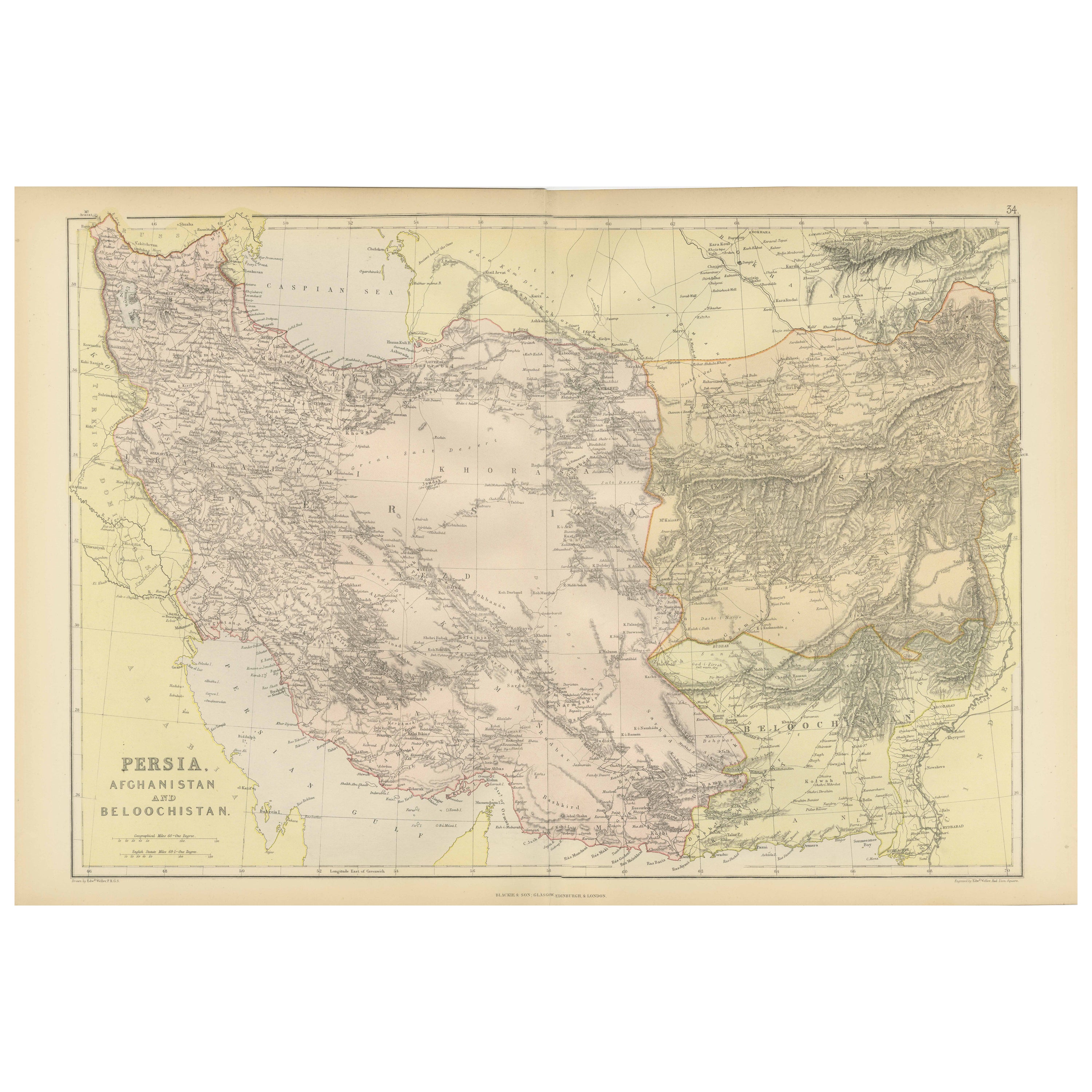
Oriental Realms: A Detailed Map of Persia, Afghanistan, and Beloochistan, 1882
Located in Langweer, NL
This historical map from the 1882 atlas published by Blackie & Son is a comprehensive depiction of Persia (modern-day Iran), Afghanistan, and Baluchistan (the region that includes pa...
Category
Antique 1880s Maps
Materials
Paper

$296 Sale Price
20% Off
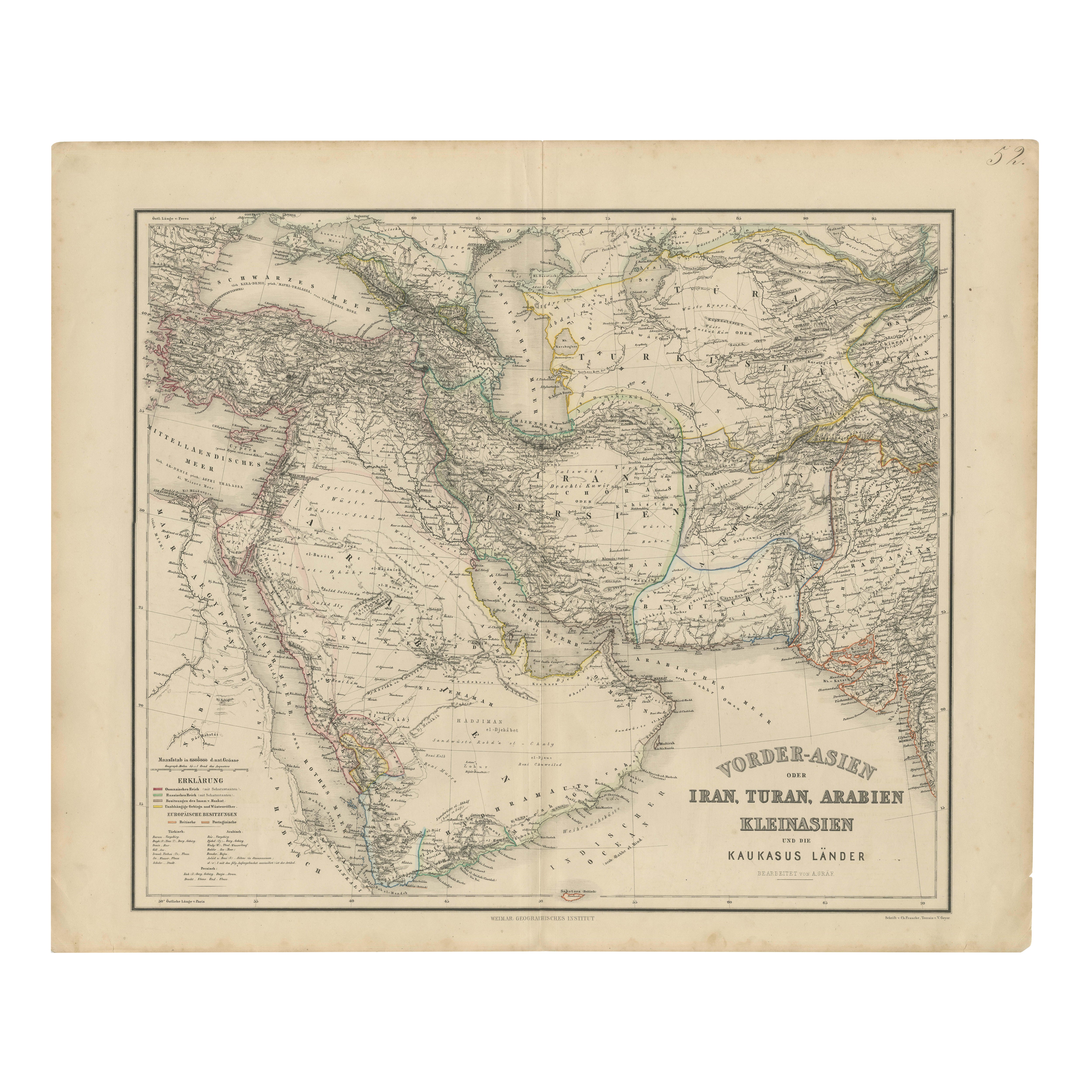
Map of Iran, Arabia, Asia Minor & Caucasus by Perthes, 1858
Located in Langweer, NL
Map of Iran, Arabia, Asia Minor & Caucasus by Perthes, 1858
This is a detailed engraved map titled Vorder-Asien oder Iran, Turan, Arabien, Kleinasien und die Kaukasus Länder, publis...
Category
Antique Mid-19th Century German Maps
Materials
Paper

You May Also Like
Large Original Vintage Map of Persia / Iran, circa 1920
Located in St Annes, Lancashire
Great maps of Persia.
Unframed.
Original color.
By John Bartholomew and Co. Edinburgh Geographical Institute.
Published, circa 1920.
Free shipping.
Category
Vintage 1920s British Maps
Materials
Paper

Large Original Antique Map of Afghanistan. Edward Weller, 1861
Located in St Annes, Lancashire
Great map of Afghanistan
Lithograph engraving by Edward Weller
Original colour
Published, 1861
Unframed
Good condition
Category
Antique 1860s English Victorian Maps
Materials
Paper

Persia, Armenia & Adjacent Regions: A Hand-colored 17th Century Map by De Wit
By Frederick de Wit
Located in Alamo, CA
This colorful and detailed 17th century copperplate map by Frederick De Wit was published in Amsterdam between 1666 and 1690. It depicts the Caspian Se...
Category
Late 17th Century Old Masters More Prints
Materials
Engraving

Persia & Afghanistan: A Framed Hand-colored 17th Century Map by John Cary
By John Cary
Located in Alamo, CA
This colorful and detailed early 18th century copperplate map by John Cary entitled "A New Map of Persia from the Latest Authorities" was published in London in 1801. It depicts Persia, the region of modern day Afghanistan, the Caspian Sea, the Sea of Aral, the Persian Gulf...
Category
Early 19th Century Old Masters More Prints
Materials
Engraving

Persia, Armenia & Adjacent Regions: A 17th Century Hand-colored Map by De Wit
By Frederick de Wit
Located in Alamo, CA
A large 17th century hand colored copperplate engraved map entitled "Novissima nec non Perfectissima Scandinaviae Tabula comprehendens Regnorum Sueciae, Daniae et Norvegiae distincte...
Category
Antique Late 17th Century Dutch Maps
Materials
Paper

Austria-Hungary, Western Part. Century Atlas antique vintage map
Located in Melbourne, Victoria
'The Century Atlas. Austria-Hungary, Western Part'
Original antique map, 1903.
Central fold as issued. Map name and number printed on the reverse corners.
Sheet 40cm by 29.5cm.
Category
Early 20th Century Victorian More Prints
Materials
Lithograph

More Ways To Browse
Solid Mahogany Table
Dessert Glasses
Geometric Glass Table
Mid Century Pin
6x10 Rug
Studded Furniture
Styles Of Antique Desks
Black And White Coffee Table
Metal Relief
Curved Velvet Couch
Velvet Curved Sofa
Wood Round Coffee Tables
Antique Paper Flowers
Oak Brutalist
Used College Furniture
Wood Minimalist Chair
2002 Lamp
Antique Imperial Furniture