Items Similar to Oriental Realms: A Detailed Map of Persia, Afghanistan, and Beloochistan, 1882

Want more images or videos?
Request additional images or videos from the seller
1 of 6
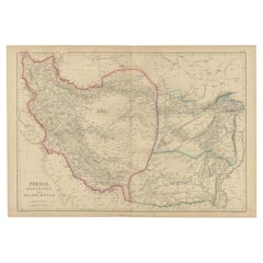
Oriental Realms: A Detailed Map of Persia, Afghanistan, and Beloochistan, 1882
About the Item
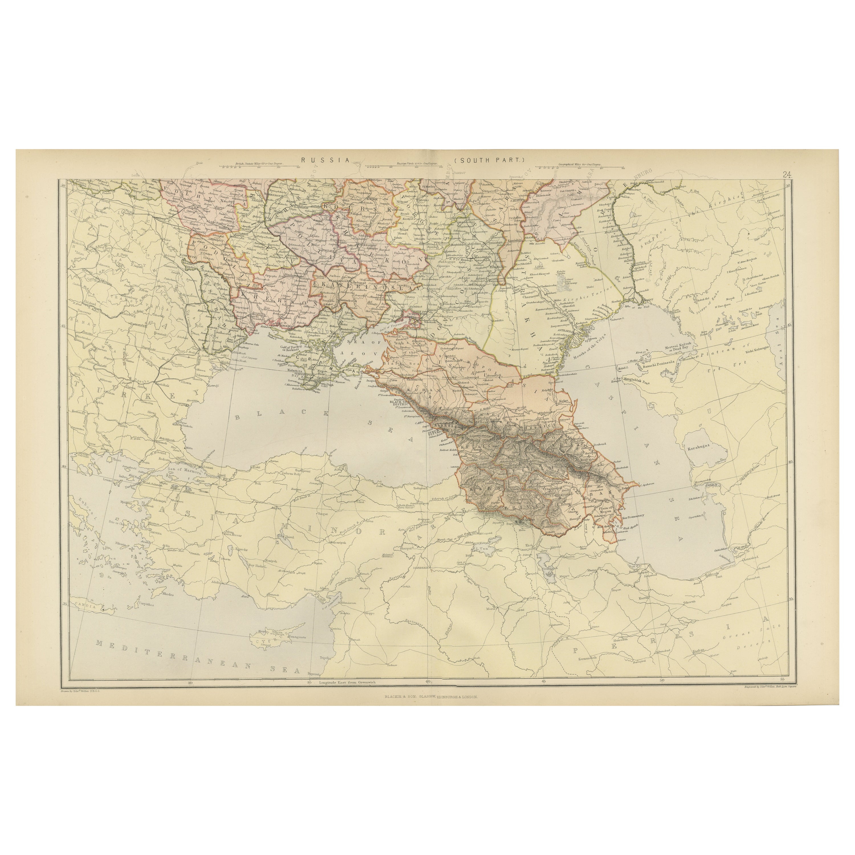
This historical map from the 1882 atlas published by Blackie & Son is a comprehensive depiction of Persia (modern-day Iran), Afghanistan, and Baluchistan (the region that includes parts of modern-day Pakistan, Iran, and Afghanistan). It offers an intricate portrayal of the region's topography, settlement patterns, and geopolitical boundaries as understood in the late 19th century.
The map is rendered with a remarkable level of detail, highlighting the complex terrain of the area with the use of hachure lines to indicate mountains and elevation. The Zagros and Elburz mountain ranges in Persia are prominently featured, illustrating the rugged landscapes that have historically shaped travel and settlement in the region.
Political boundaries are marked with colored lines, differentiating the three regions while also demarcating the smaller subdivisions within them. Cities and towns are pinpointed, with major urban centers such as Tehran, Kabul, and Quetta given prominence. This reflects not only their contemporary significance but also their roles as centers of trade and governance.
Rivers, lakes, and other bodies of water are carefully charted, serving as vital lifelines for the communities they support. The map also traces the routes of important passes, such as the Khyber Pass, underscoring their strategic importance in trade and military history.
This map would have been a crucial resource for explorers, traders, and imperial strategists, providing a wealth of information essential for navigation and understanding the complex dynamics of the region. As a document, it encapsulates the blend of knowledge and assumption characteristic of the period, offering a snapshot of the Great Game era when the British and Russian empires vied for influence in Central Asia.
- Dimensions:Height: 14.97 in (38 cm)Width: 22.45 in (57 cm)Depth: 0 in (0.02 mm)
- Materials and Techniques:
- Period:
- Date of Manufacture:1882
- Condition:Good condition, folding line in the middle. The outer borders are slightly discolored due to age, but not the image. This map is ideal for framing. Study the image carefully.
- Seller Location:Langweer, NL
- Reference Number:Seller: BG-13601-2-451stDibs: LU3054337696212
About the Seller
5.0
Platinum Seller
These expertly vetted sellers are 1stDibs' most experienced sellers and are rated highest by our customers.
Established in 2009
1stDibs seller since 2017
1,922 sales on 1stDibs
Typical response time: <1 hour
- ShippingRetrieving quote...Ships From: Langweer, Netherlands
- Return PolicyA return for this item may be initiated within 14 days of delivery.
Auctions on 1stDibs
Our timed auctions are an opportunity to bid on extraordinary design. We do not charge a Buyer's Premium and shipping is facilitated by 1stDibs and/or the seller. Plus, all auction purchases are covered by our comprehensive Buyer Protection. Learn More
More From This SellerView All
- Antique Map of Persia and Afghanistan by Johnston, 1882Located in Langweer, NLAntique map titled 'Persia and Afghanistan'. Old map of Persia and Afghanistan. This map originates from 'The Royal Atlas of Modern Geography, Exhibiting, in a Series of Entirely O...Category
Antique 19th Century Maps
MaterialsPaper
- Antique Map of Persia, Afghanistan and Balochistan, 1859Located in Langweer, NLThe antique map titled "Persia, Afghanistan and Beloochistan" is a remarkable historical document originating from 'The Imperial Atlas of Modern Geography', published by W. G. Blacki...Category
Antique Mid-19th Century Maps
MaterialsPaper
- Antique Map of Turkey, Persia and Afghanistan, 1842By Pierre M. LapieLocated in Langweer, NLAntique map titled 'Carte de la Turquie d'Asia, de la Perse, de l'Afghanistan'. Map of Turkey, Persia and Afghanistan. This map originates from 'Atlas universel de géographie ancienn...Category
Antique 19th Century Maps
MaterialsPaper
- Colorful Detailed Antique Map of England and Wales, 1882Located in Langweer, NLExplore the Historic Splendor of 'England and Wales' with this Antique Map! Part of a distinguished collection, this map presents a captivating view of the enchanting landscapes, cit...Category
Antique 1880s Maps
MaterialsPaper
- Antique Map of Persia and Afghanistan by Johnston '1909'Located in Langweer, NLAntique map titled 'Persia and Afghanistan'. Original antique map of Persia and Afghanistan. This map originates from the ‘Royal Atlas o...Category
Early 20th Century Maps
MaterialsPaper
- Persia Unveiled: Antique Map of Iran, Afghanistan, and Beyond, 1852Located in Langweer, NLThe antique map titled 'Royaumes de Perse Herat & Kaboul' is an attractive map of Persia. Here are the key details and features of the map: 1. **Geographic Coverage**: - The map ...Category
Antique Mid-19th Century Maps
MaterialsPaper


You May Also Like
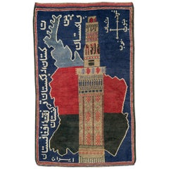
- Vintage Afghan Pictorial Map RugLocated in New York, NYA vintage Afghan Pictorial map rug from the mid-20th century. Measures: 3' 0" x 4' 10"Category
Mid-20th Century Afghan Folk Art Central Asian Rugs
MaterialsWool
- Vintage World Map Mirror Based on the Original by Johnson 1882 Military CampaignLocated in GBWe are delighted to offer for sale this lovely Antique style pictorial plan map of the globe based on the original by Johnson in 1882 This is a very interesting and decorative pie...Category
20th Century English Campaign Maps
MaterialsMirror
- Persia, Armenia & Adjacent Regions: A 17th Century Hand-colored Map by De WitBy Frederick de WitLocated in Alamo, CAA large 17th century hand colored copperplate engraved map entitled "Novissima nec non Perfectissima Scandinaviae Tabula comprehendens Regnorum Sueciae, Daniae et Norvegiae distincte...Category
Antique Late 17th Century Dutch Maps
MaterialsPaper
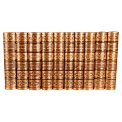
- 1882 The Works of Henry Fielding, Esq.By Henry FieldingLocated in Bath, GBA limited edition ten-volume set of the works of Henry Fielding, edited with a biography by Leslie Stephen. A ten-volume set in half morocco bindings. All edges gilt. No. 92 of a t...Category
Antique 1880s British Books
MaterialsPaper
- Map of Boston and Surrounding TownsLocated in Norwell, MALater copy of a nineteenth century map of Boston and surrounding towns. Showing parts of Quincy, Milton, Hyde Park, Winthrop and Revere. Showing all of B...Category
Antique 19th Century North American Maps
MaterialsPaper
- 1854 Map of Massachusetts, Connecticut and Rhode Island, Antique Wall MapLocated in Colorado Springs, COThis striking wall map was published in 1854 by Ensign, Bridgman & Fanning and has both full original hand-coloring and original hardware. This impression is both informative and highly decorative. The states are divided into counties, outlined in red, green, and black, and subdivided into towns. Roads, canals, and railroad lines are prominently depicted, although they are not all labeled. The mapmakers also marked lighthouses, banks, churches, and prominent buildings, with a key at right. The map is an informative and comprehensive overview of the infrastructural development of New England prior to the Civil War. Physical geographies depicted include elevation, conveyed with hachure marks, rivers and lakes. The impression features an inset map of Boston...Category
Antique 19th Century American Maps
MaterialsPaper


Recently Viewed
View AllMore Ways To Browse
Engraved Cross
Collectors And Curiosities
Minature Map
Anguilla Map
James Calvert Smith
Winkler Prins
A Plan City And Castle Of Batavia
Antique Maine Maps
Shetland Map
Antique Map Iceland
Antique Map Of Iceland
Antique Map Of Maine
Tartar Map
Victor Levasseur On Sale
Antique Curiosities North Carolina
Bolivia Antique Map
Irish Canterbury Furniture
Irish Canterbury