Items Similar to Imperial Frontiers: A 19th Century Map of Southern Russia and the Caucasus, 1882

Want more images or videos?
Request additional images or videos from the seller
1 of 6
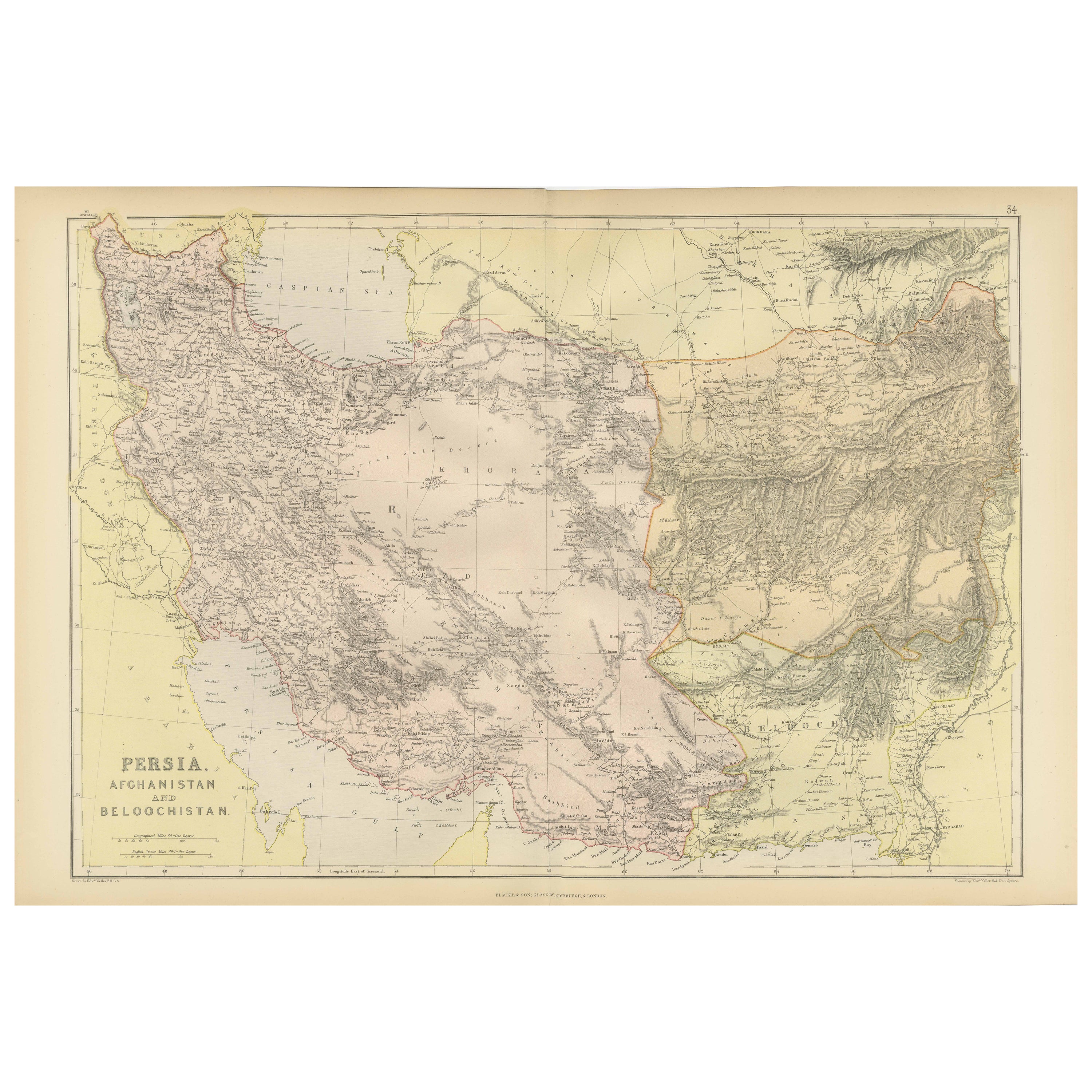
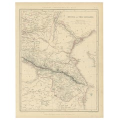
Imperial Frontiers: A 19th Century Map of Southern Russia and the Caucasus, 1882
About the Item
This map, sourced from the comprehensive 1882 atlas by Blackie & Son, delineates the southern part of Russia and the Caucasus region, reflecting the geopolitical contours and topographical details of the area as known in the late 19th century.
The map extends from the Black Sea to the west, across the Caucasus mountain range, and into the Caspian Sea to the east. The intricacies of the Caucasus, a region known for its complex geography and diversity of peoples, are finely etched into the map. The region's rugged terrain is represented through hachure marks, illustrating the stark relief and the formidable natural barriers that have historically made this area a crossroads of various empires and cultures.
Provincial boundaries within the Russian Empire are outlined and shaded with different colors, offering a clear distinction between the various administrative divisions. This includes the territories that would later become nations such as Georgia, Armenia, and Azerbaijan. Major cities, rivers, and the network of roads and passes that were crucial for trade and military movements are also noted with precision.
To the south, the map also encompasses parts of the Ottoman Empire and Persia (modern-day Turkey and Iran), providing a broader context for the strategic importance of the Caucasus as a buffer zone between the great powers of the time.
This map would have been a valuable resource for understanding the complex political and physical landscape of the region. It serves as a historical document, capturing the imperial dynamics of the era and the meticulous detail that went into the cartographic endeavors of the period.
- Dimensions:Height: 14.97 in (38 cm)Width: 22.45 in (57 cm)Depth: 0 in (0.02 mm)
- Materials and Techniques:
- Period:
- Date of Manufacture:1882
- Condition:Good condition, folding line in the middle. The outer borders are slightly discolored due to age, but not the image. This map is ideal for framing. Study the image carefully.
- Seller Location:Langweer, NL
- Reference Number:Seller: BG-13601-2-351stDibs: LU3054337696232
About the Seller
5.0
Platinum Seller
These expertly vetted sellers are 1stDibs' most experienced sellers and are rated highest by our customers.
Established in 2009
1stDibs seller since 2017
1,919 sales on 1stDibs
Typical response time: <1 hour
- ShippingRetrieving quote...Ships From: Langweer, Netherlands
- Return PolicyA return for this item may be initiated within 14 days of delivery.
Auctions on 1stDibs
Our timed auctions are an opportunity to bid on extraordinary design. We do not charge a Buyer's Premium and shipping is facilitated by 1stDibs and/or the seller. Plus, all auction purchases are covered by our comprehensive Buyer Protection. Learn More
More From This SellerView All
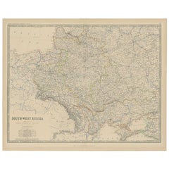
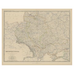
- Antique Map of Southern Russia by Johnston, 1882Located in Langweer, NL"Antique map titled 'South-West Russia'. Old map of southern Russia, also showing the extent of the Kingdom of Poland. This map originates from 'The Royal Atlas of Modern Geography, ...Category
Antique 19th Century Maps
MaterialsPaper
- Old Map of Southern Russia, Incl the Extent of the Kingdom of Poland, 1882Located in Langweer, NLAntique map titled 'South-West Russia'. Old map of southern Russia, also showing the extent of the Kingdom of Poland. This map originates from 'The Royal Atlas of Modern Geography...Category
Antique 1880s Maps
MaterialsPaper
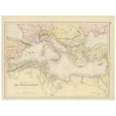
- Mediterranean Tapestry: A 19th Century Map of the Mediterranean Shores, 1882Located in Langweer, NLThis map, titled "The Shores of the Mediterranean," is part of the 1882 atlas by Blackie & Son, and it portrays the coastal regions that surround the Mediterranean Sea. It is a detailed representation of the diverse and historically rich countries that share the Mediterranean coastline, spanning from the Strait of Gibraltar in the west to the Levantine Sea in the east, and from the southern shores of Europe down to the northern coastlines of Africa. The map is a vivid document of the time, with each country along the Mediterranean basin meticulously outlined. The northern coast includes the southern parts of Europe, featuring Spain...Category
Antique 1880s Maps
MaterialsPaper
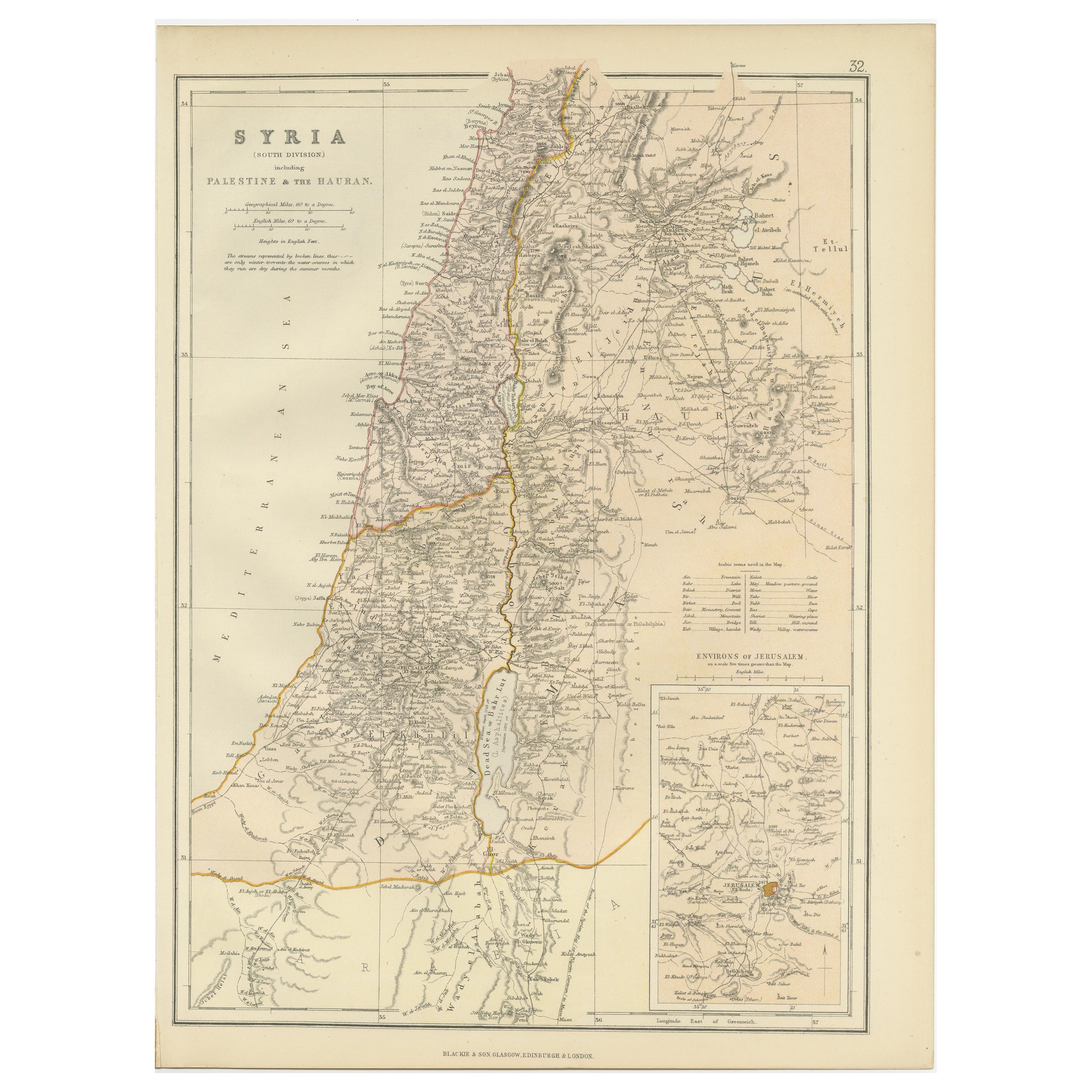
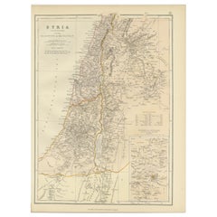
- An Insightful 19th Century Map of Syria and the Surrounding Regions, 1882Located in Langweer, NLThis map, titled "SYRIA (SOUTH DIVISION) including PALESTINE & THE HAUARAN," is a historical cartographic work from the late 19th century, specifically from the 1882 atlas by Blackie...Category
Antique 1880s Maps
MaterialsPaper
- Antique Map of Russia and the Caucasus by Sharpe, 1849Located in Langweer, NLAntique map titled 'Russia at the Caucasus'. Old map of Russia and the Caucasus, also shows part of the Black Sea and Caspian Sea. This map originates from 'Sharpe's Corresponding Atlas (..)' by J. Sharpe. Artists and Engravers: Published by Chapman and Hall...Category
Antique 19th Century Maps
MaterialsPaper
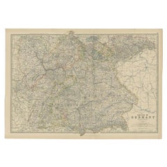
- Antique Map of the 'Southern' German Empire by Johnston, 1882Located in Langweer, NLAntique map titled 'Empire of Germany'. Old map of the southern portion of the German Empire. This map originates from 'The Royal Atlas of Modern Geography, Exhibiting, in a Series o...Category
Antique 19th Century Maps
MaterialsPaper
You May Also Like
- 18th Century Map of the Southern Balkans by Giovanni Maria CassiniBy Giovanni Maria CassiniLocated in Hamilton, Ontario18th century map by Italian engraver Giovanni Maria Cassini (Italy 1745-1824). Map of the Southern Balkans: Rome. Hand colored and copper engraved print done in the year 1788. It in...Category
Antique 18th Century Italian Maps
MaterialsPaper
- The Kingdom of Naples and Southern Italy: A Hand-Colored 18th Century Homann MapBy Johann Baptist HomannLocated in Alamo, CA"Novissima & exactissimus Totius Regni Neapolis Tabula Presentis Belli Satui Accommo Data" is a hand colored map of southern Italy and the ancient Kingdom of Naples created by Johann...Category
Antique Early 18th Century German Maps
MaterialsPaper
- Skinner's the Fletcher Collection of Imperial RussiaLocated in valatie, NYEuropean Furniture & Decorative Arts Featuring Fine Silver and The Fletcher Collection of Imperial Russia. Skinner, Boston, April 6, 2013. softcover auction catalog. This sale featured The Fletcher Collection of Imperial Russia and over 300 lots of fine silver. The sale also presented Continental and British ceramics, clocks, lighting, textiles, antique furniture and a variety of American and European sculpture from a private Midwest collector. John Fletcher always had an intense interest in Nicholas II and his family. After over fifty years working with auction houses and specialized dealers worldwide, Fletcher had amassed a collection reflecting the splendor of Russia’s cultural Golden and Silver Ages. Highlights from the collection included a white leather child’s shoe, by tradition belonging to Tsarevich Alexei Nikolaevich; a pair of Fabergé gilded silver and enamel napkin rings; a collodion print of the Russian Imperial Family...Category
21st Century and Contemporary Books
MaterialsPaper
- Early 19th Century Hand Colored Map of the United States and Caribbean IslandsLocated in Hamilton, OntarioHand coloured early 19th century map by Giraldon of France titled "Etats Unis et Grandes Antilles" (United States and Greater Antilles).Category
Antique Early 19th Century French Maps
MaterialsPaper
- Framed Mid-19th Century Wall Map of Long Island, the HamptonsLocated in Sag Harbor, NYA Framed museum quality find. This large wall map dates to the mid-1800s. Detailed inset maps of, Sag Harbor, East Hampton, Amagansett, Shelter Island and most villages in Long Islan...Category
Antique Mid-19th Century American Maps
MaterialsLinen, Paper
- Russian 19th Century Silver Icon of Christ PantocratorLocated in London, GBRussian 19th century silver icon of Christ Pantocrator Moscow, 1883 Height 50cm, width 41.5cm, depth 3cm The piece, steeped in Russian Orthodox tradition, portrays Christ Pantocrator, a term synonymous with the 'Ruler of All'. Christ Pantocrator icons...Category
Antique 1880s Russian Religious Items
MaterialsSilver


Recently Viewed
View AllMore Ways To Browse
Engraved Cross
Collectors And Curiosities
Minature Map
Anguilla Map
James Calvert Smith
Winkler Prins
A Plan City And Castle Of Batavia
Antique Maine Maps
Shetland Map
Antique Map Iceland
Antique Map Of Iceland
Antique Map Of Maine
Tartar Map
Victor Levasseur On Sale
Antique Curiosities North Carolina
Bolivia Antique Map
Irish Canterbury Furniture
Irish Canterbury