Items Similar to Antique Map of Southern Russia by Johnston, 1882

Want more images or videos?
Request additional images or videos from the seller
1 of 5
Antique Map of Southern Russia by Johnston, 1882
About the Item
"Antique map titled 'South-West Russia'. Old map of southern Russia, also showing the extent of the Kingdom of Poland. This map originates from 'The Royal Atlas of Modern Geography, Exhibiting, in a Series of Entirely Original and Authentic Maps, the Present Condition of Geographical Discovery and Research in the Several Countries, Empires, and States of the World' by A.K. Johnston. Published by W. and A.K. Johnston, 1882. Artists and Engravers: Alexander Keith Johnston LLD (1804-1871) was a Scottish geographer. He was a pupil of the Edinburgh engraver and mapmaker, James Kirkwood. In 1826, he joined his brother William (who would become Sir William Johnston, Lord Provost of Edinburgh) in a printing and engraving business, forming the well-known cartographical firm of W. and A. K. Johnston.
Artist: Alexander Keith Johnston LLD (1804-1871) was a Scottish geographer. He was a pupil of the Edinburgh engraver and mapmaker, James Kirkwood. In 1826, he joined his brother William (who would become Sir William Johnston, Lord Provost of Edinburgh) in a printing and engraving business, forming the well-known cartographical firm of W. and A. K. Johnston.
Condition: Good, general age-related toning. Please study image carefully.
Date: 1882
Overall size: 61.2 x 49.6 cm.
Image size: 0.001 x 57.3 x 44.3 cm.
Antique prints have long been appreciated for both their aesthetic and investment value. They were the product of engraved, etched or lithographed plates. These plates were handmade out of wood or metal, which required an incredible level of skill, patience and craftsmanship. Whether you have a house with Victorian furniture or more contemporary decor an old engraving can enhance your living space. We offer a wide range of authentic antique prints for any budget.".
- Dimensions:Height: 19.53 in (49.6 cm)Width: 24.1 in (61.2 cm)Depth: 0 in (0.01 mm)
- Materials and Techniques:
- Period:
- Date of Manufacture:1882
- Condition:
- Seller Location:Langweer, NL
- Reference Number:
About the Seller
5.0
Platinum Seller
These expertly vetted sellers are 1stDibs' most experienced sellers and are rated highest by our customers.
Established in 2009
1stDibs seller since 2017
1,947 sales on 1stDibs
Typical response time: <1 hour
- ShippingRetrieving quote...Ships From: Langweer, Netherlands
- Return PolicyA return for this item may be initiated within 14 days of delivery.
More From This SellerView All
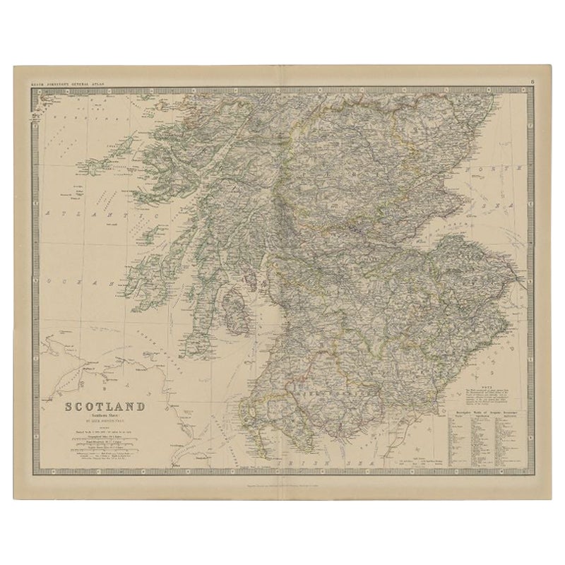
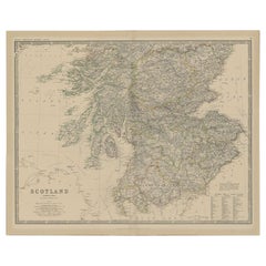
- Antique Map of Southern Scotland by Johnston, 1882Located in Langweer, NL"Antique map titled 'Scotland'. Old map of Southern Scotland. This map originates from 'The Royal Atlas of Modern Geography, Exhibiting, in a Series of Entirely Original and Authenti...Category
Antique 19th Century Maps
MaterialsPaper
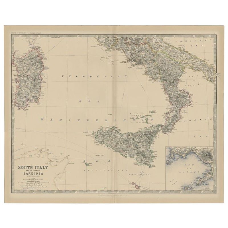
- Antique Map of Southern Italy and Sardinia by Johnston, 1882Located in Langweer, NL"Antique map titled 'South Italy and the Island of Sardinia'. Old map of Southern Italy and the island of Sardinia. With an inset map of the Bay ...Category
Antique 19th Century Maps
MaterialsPaper
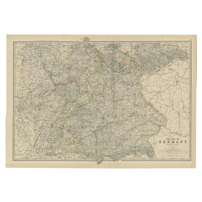
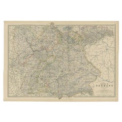
- Antique Map of the 'Southern' German Empire by Johnston, 1882Located in Langweer, NLAntique map titled 'Empire of Germany'. Old map of the southern portion of the German Empire. This map originates from 'The Royal Atlas of Modern Geography, Exhibiting, in a Series o...Category
Antique 19th Century Maps
MaterialsPaper
- Antique Map of Switzerland by Johnston, 1882Located in Langweer, NLAntique map titled 'Switzerland and the Alps of Savoy and Piedmont'. Old map of Switzerland and the Alps of Savoy and Piedmont. This map originates from 'The Royal Atlas of Modern Ge...Category
Antique 19th Century Maps
MaterialsPaper
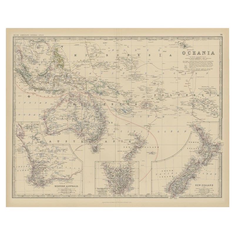
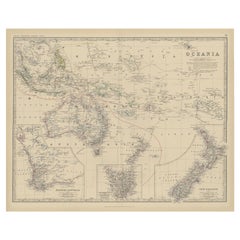
- Antique Map of Oceania by Johnston, 1882Located in Langweer, NLAntique map titled 'Oceania'. Old map of Oceania with inset maps of Western Australia, Tasmania and New Zealand. This map originates from 'The Royal Atlas of Modern Geography, Exhibi...Category
Antique 19th Century Maps
MaterialsPaper
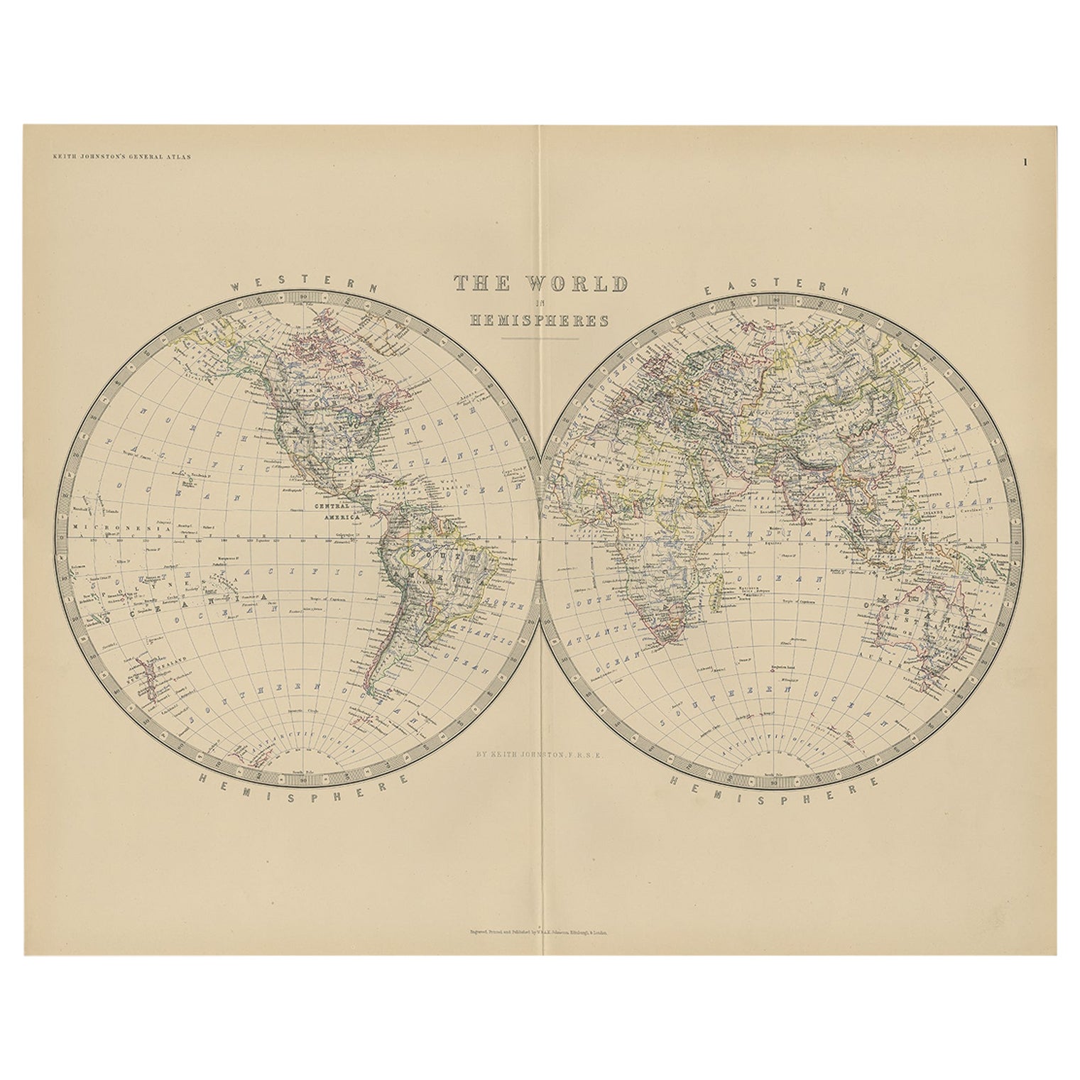
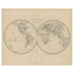
- Antique World Map by Johnston, 1882Located in Langweer, NLAntique map titled 'The World in Hemispheres'. Old double-hemisphere world map. This map originates from 'The Royal Atlas of Modern Geography, Exhibiting, in a Series of Entirely Ori...Category
Antique 19th Century Maps
MaterialsPaper


You May Also Like
- Original Antique Map of Russia By Arrowsmith. 1820Located in St Annes, LancashireGreat map of Russia Drawn under the direction of Arrowsmith Copper-plate engraving Published by Longman, Hurst, Rees, Orme and Brown, 1820 Unframed.Category
Antique 1820s English Maps
MaterialsPaper
- 18th Century Map of the Southern Balkans by Giovanni Maria CassiniBy Giovanni Maria CassiniLocated in Hamilton, Ontario18th century map by Italian engraver Giovanni Maria Cassini (Italy 1745-1824). Map of the Southern Balkans: Rome. Hand colored and copper engraved print done in the year 1788. It in...Category
Antique 18th Century Italian Maps
MaterialsPaper
- 1814 Map of "Russian Empire" Ric.r032Located in Norton, MA1814 Map of "Russian Empire" Ric.r032 Russian Empire. Description: This is an 1814 John Thomson map of the Russian Empire. The map depicts the region from the Baltic Sea, Prussia, and Sweden to the Aleutian Islands and from the Arctic Ocean to the Yellow River. Highly detailed, myriad cities, towns, and villages are labeled throughout, including St. Petersburg, Moscow, Minsk, Kiev, and Kharkov. Rivers and mountain ranges are also identified, as are islands and numerous locations along the coastlines. It is important to note that the long-disputed sea between Korea and Japan is identified as the 'Sea of Japan. Historical Context: In 1815, Tsarist Russia emerged from the Napoleonic Wars economically insolvent and politically fearful of the Revolutionary fervor that had just swept through Europe. In order to shore up Russia's economic position, the Tsars began an aggressive series of expansions into the Caucuses and Central Asia that would vastly increase the landmass of the Russian Empire. Publication History Thomson maps are known for their stunning color, awe inspiring size, and magnificent detail. Thomson's work, including this map, represents some of the finest cartographic art...Category
Antique 19th Century Unknown Maps
MaterialsPaper
- Map Southern Scotland Thomas Conder Alex Hogg 1795Located in BUNGAY, SUFFOLKA new map of the southern part of Scotland containing the counties of Stirling, Lanerk, Renfrew, Linlithgow, Edinburgh, Peebles, Haddingtoun, Berwick, Selkirk, Roxburgh, Dumfries, Wigtoun, Kirkudbright & Air Published by Alex Hogg at the Kings Arms...Category
Antique 18th Century English Georgian Maps
MaterialsPaper
- Antique Lithography Map, Western Russia, English, Framed, Cartography, VictorianLocated in Hele, Devon, GBThis is an antique lithography map of Western Russia. An English, framed atlas engraving of cartographic interest by John Rapkin, dating to the early Victorian period and later, circ...Category
Antique Mid-19th Century British Early Victorian Maps
MaterialsWood
- 1849 Map of "Europaische Russland", 'Meyer Map of European Russia', Ric. R017Located in Norton, MA1849 Map of "Europaische Russland" ( Meyer Map of European Russia) Ric.r017 A lovely map of European Russia dating to 1849 by Joseph Meyer. It covers the European portions of...Category
Antique 19th Century Unknown Maps
MaterialsPaper


Recently Viewed
View AllMore Ways To Browse
Southern Used Furniture
Antique Russian Plate
Antique Russian Plates
Alexander James
Antique Prints Edinburgh
Empire Antiques Plate
Antique Prints Of Edinburgh
Antique Russian Empire
Map Of Scotland
Map Edinburgh
Scottish Lord
Antique Russian Wood Furniture
Antique Russian Wood
Antique Map Edinburgh
Antique Map Of Edinburgh
Antique Map Series
Antique Maps Of Russia
Alexander Keiths