Items Similar to Persia Unveiled: Antique Map of Iran, Afghanistan, and Beyond, 1852


Want more images or videos?
Request additional images or videos from the seller
1 of 6
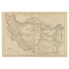
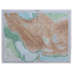
Persia Unveiled: Antique Map of Iran, Afghanistan, and Beyond, 1852
About the Item
The antique map titled 'Royaumes de Perse Herat & Kaboul' is an attractive map of Persia. Here are the key details and features of the map:
1. **Geographic Coverage**:
- The map covers a significant portion of the region, including modern-day Iran and Afghanistan.
- It extends from the Caspian Sea in the north to the Persian Gulf in the south.
- The map also includes parts of adjacent countries, such as Pakistan, India, and Iraq.
2. **Cartographic Details**:
- The map provides detailed cartographic information, including the depiction of geographical features, rivers, mountains, and place names.
- It offers a comprehensive view of the topography of the covered regions.
3. **Origin**:
- This map originates from Maison Basset's 1852 edition of 'Atlas Illustre Destine a l'enseignement de la Geographie elementaire.' This suggests that it was intended for educational purposes and likely used in geography education during the mid-19th century.
4. **Educational Use**:
- The map's inclusion in an atlas for geography education indicates its role in helping students learn about the geography of the covered regions.
- It may have been used as a teaching tool to enhance students' understanding of Persia, Herat, Kaboul, and the surrounding areas.
5. **Aesthetic Appeal**:
- The map is described as attractive, suggesting that it was not only informative but also visually appealing.
- Maps from this era often featured intricate and decorative elements that added to their aesthetic value.
6. **Historical Insight**:
- The map provides historical insights into the territorial boundaries and geographic knowledge of the regions it covers during the mid-19th century.
7. **Geopolitical Significance**:
- Persia, Herat, and Kaboul (Kabul) have historical and geopolitical significance, and this map offers a view of their positions and relationships within the broader region.
Overall, the 'Royaumes de Perse Herat & Kaboul' antique map serves as both an educational tool and a historical document, offering a glimpse into the geography of Persia and its neighboring regions in the mid-19th century.
- Dimensions:Height: 10.12 in (25.7 cm)Width: 13.31 in (33.8 cm)Depth: 0.02 in (0.5 mm)
- Materials and Techniques:
- Period:
- Date of Manufacture:1852
- Condition:General age-related toning. Shows soiling and foxing, blank verso. Please study image carefully.
- Seller Location:Langweer, NL
- Reference Number:
About the Seller
5.0
Platinum Seller
These expertly vetted sellers are 1stDibs' most experienced sellers and are rated highest by our customers.
Established in 2009
1stDibs seller since 2017
1,929 sales on 1stDibs
Typical response time: <1 hour
- ShippingRetrieving quote...Ships From: Langweer, Netherlands
- Return PolicyA return for this item may be initiated within 14 days of delivery.
More From This SellerView All
- Antique Map of Eastern Persia, 1852Located in Langweer, NLAntique map titled 'Eastern Persia'. Original map of Eastern Persia. This map originates from 'Lowry's Table Atlas constructed and engraved from the most recent Authorities' by J.W. ...Category
Antique Mid-19th Century Maps
MaterialsPaper
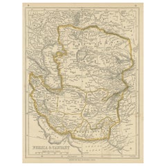
- Antique Map of Persia and Tartary by Lowry, '1852'Located in Langweer, NLAntique map titled 'Persia and Tartary'. Original map of Persia and Tartary. This map originates from 'Lowry's Table Atlas constructed and engraved from the most recent Authorities' ...Category
Antique Mid-19th Century Maps
MaterialsPaper
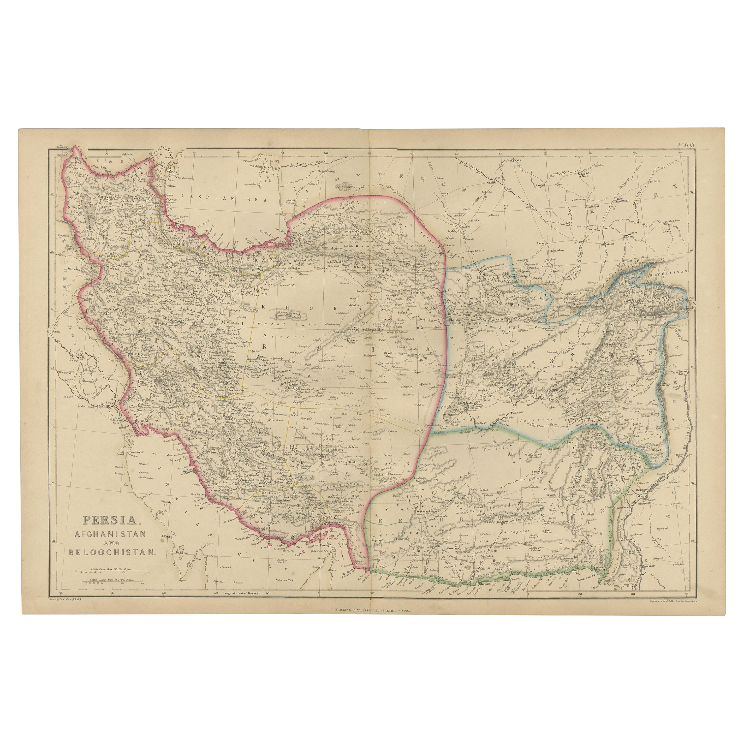
- Antique Map of Persia, Afghanistan and Balochistan, 1859Located in Langweer, NLThe antique map titled "Persia, Afghanistan and Beloochistan" is a remarkable historical document originating from 'The Imperial Atlas of Modern Geography', published by W. G. Blacki...Category
Antique Mid-19th Century Maps
MaterialsPaper
- Antique Map of Persia and Afghanistan by Johnston '1909'Located in Langweer, NLAntique map titled 'Persia and Afghanistan'. Original antique map of Persia and Afghanistan. This map originates from the ‘Royal Atlas o...Category
Early 20th Century Maps
MaterialsPaper
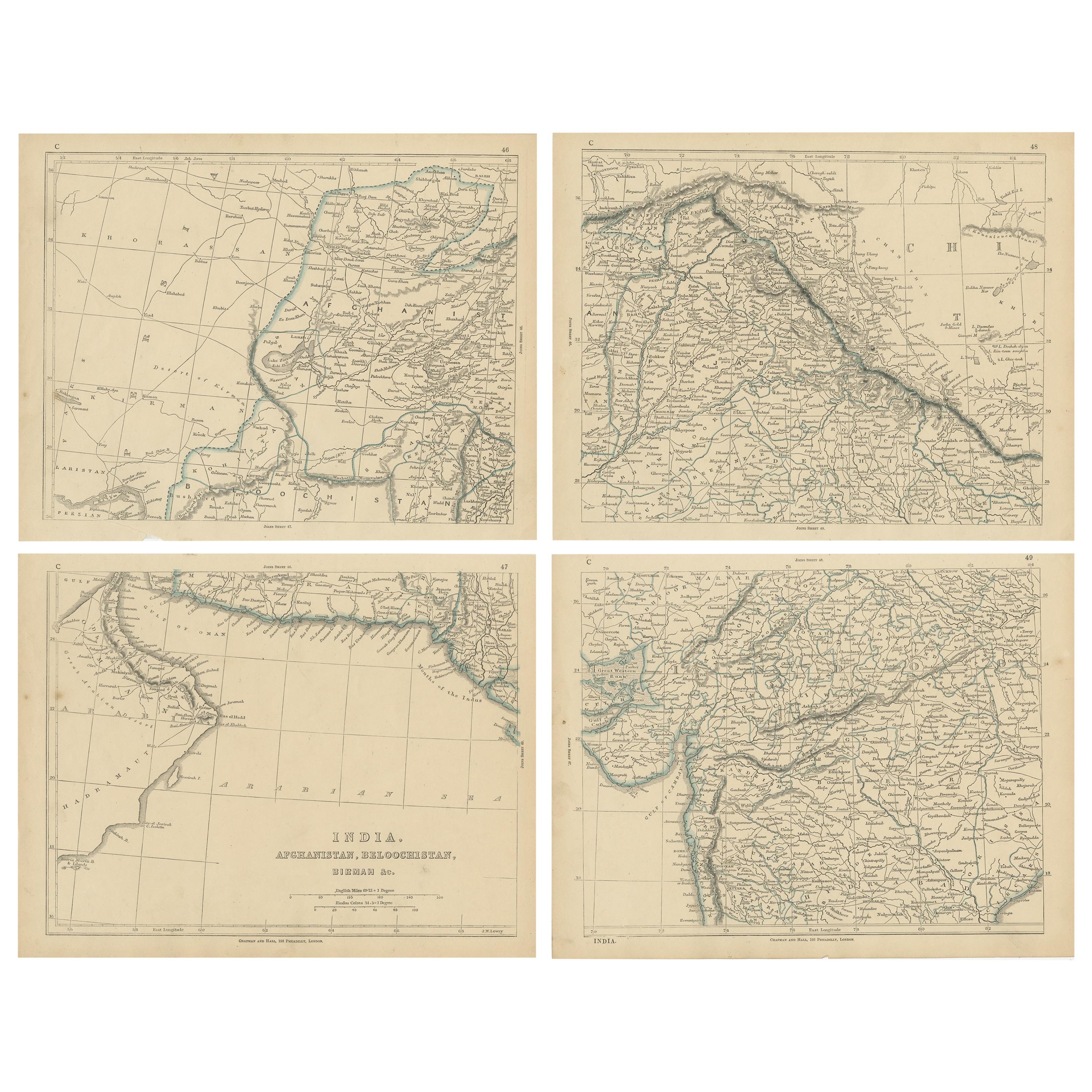
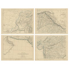
- Antique Map of India, Afghanistan, Balochistan and surroundings by Lowry, '1852'Located in Langweer, NLAntique map titled 'India, Afghanistan, Beloochistan, Birmah & C'. Four individual sheets of India, Afghanistan, Baluchistan and surroundings. This map originates from 'Lowry's Table...Category
Antique Mid-19th Century Maps
MaterialsPaper
- Antique Map of the Bosporus and Dardanelles, 1852Located in Langweer, NLAntique map titled 'The Bosphorus and Dardanelles'. Original map of the Bosphorus and Dardanelles. This map originates from 'Lowry's Table Atlas constructed and engraved from the mos...Category
Antique Mid-19th Century Maps
MaterialsPaper


You May Also Like
- Large Original Vintage Map of Persia / Iran, circa 1920Located in St Annes, LancashireGreat maps of Persia. Unframed. Original color. By John Bartholomew and Co. Edinburgh Geographical Institute. Published, circa 1920. Free shipping.Category
Vintage 1920s British Maps
MaterialsPaper
- Antique Map of Principality of MonacoBy Antonio Vallardi EditoreLocated in Alessandria, PiemonteST/619 - "Old Geographical Atlas of Italy - Topographic map of ex-Principality of Monaco" - ediz Vallardi - Milano - A somewhat special edition ---Category
Antique Late 19th Century Italian Other Prints
MaterialsPaper
- Original Antique Map of Spain and Portugal, circa 1790Located in St Annes, LancashireSuper map of Spain and Portugal Copper plate engraving by A. Bell Published, circa 1790. Unframed.Category
Antique 1790s English Other Maps
MaterialsPaper
- Original Antique Map of Ireland- Tipperary and Waterford. C.1840Located in St Annes, LancashireGreat map of Tipperary and Waterford Steel engraving Drawn under the direction of A.Adlard Published by How and Parsons, C.1840 Unframed.Category
Antique 1840s English Maps
MaterialsPaper
- Original Antique Map of Sweden and Norway, Grattan and Gilbert, 1843Located in St Annes, LancashireGreat map of Sweden and Norway Drawn and engraved by Archer Published by Grattan and Gilbert Original color Unframed.Category
Antique 1840s English Other Maps
MaterialsPaper
- Original Antique Map of United States, Grattan and Gilbert, 1843Located in St Annes, LancashireGreat map of United States Drawn and engraved by Archer Published by Grattan and Gilbert. 1843 Original colour Unframed.Category
Antique 1840s English Maps
MaterialsPaper


Recently Viewed
View AllMore Ways To Browse
Pakistan Antique Map
Antique Map Bahamas
Antique Map Ontario
Antique Maps Ontario
Map Lebanon
Antique Map Montreal
Antique Maps San Diego
Lebanon Antique Map
Montreal Map
Antique Furniture Perth Australia
Antique Maps Perth
Barbados Map
Antique Map Connecticut
Antique Map Of Republic Of Texas
Antique Route 66
Giovanni Maria Cassini On Sale
Antique Map Cleveland
Antique Maps Washington Dc