Items Similar to Antique Map of the Province of Quey-Chew by Du Halde, 1738

Want more images or videos?
Request additional images or videos from the seller
1 of 5
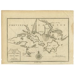
Antique Map of the Province of Quey-Chew by Du Halde, 1738
$244.35
$305.4420% Off
£182.90
£228.6320% Off
€207.20
€25920% Off
CA$336.30
CA$420.3720% Off
A$374.84
A$468.5520% Off
CHF 196.67
CHF 245.8320% Off
MX$4,577.41
MX$5,721.7620% Off
NOK 2,490.22
NOK 3,112.7720% Off
SEK 2,353.63
SEK 2,942.0420% Off
DKK 1,577.35
DKK 1,971.6920% Off
About the Item
Antique map titled 'Province XV Quey-Chew drawn on the spot by the Peres Fridelli and Regis in the year 1716'. Old map of the Chinese province Quey-Chew. Originates from the Edward Cave folio edition of 'A description of the Empire of China and Chinese tartary (..)'. An important encyclopedic work on Chinese culture, history and society, by a French Jesuit who specialized in China. Du Halde's work inspired great interest in China among Europeans, and was a ground breaking work in geography.
Artists and Engravers: Published by Edward Cave, London.
Condition: Good, some small defects and a few worm holes. General age-related toning, please study image carefully.
Date: 1738
Overall size: 46 x 35.5 cm.
Image size: 30 x 25 cm.
We sell original antique maps to collectors, historians, educators and interior decorators all over the world. Our collection includes a wide range of authentic antique maps from the 16th to the 20th centuries. Buying and collecting antique maps is a tradition that goes back hundreds of years. Antique maps have proved a richly rewarding investment over the past decade, thanks to a growing appreciation of their unique historical appeal. Today the decorative qualities of antique maps are widely recognized by interior designers who appreciate their beauty and design flexibility. Depending on the individual map, presentation, and context, a rare or antique map can be modern, traditional, abstract, figurative, serious or whimsical. We offer a wide range of authentic antique maps for any budget.
- Dimensions:Height: 13.98 in (35.5 cm)Width: 18.12 in (46 cm)Depth: 0 in (0.01 mm)
- Materials and Techniques:
- Period:
- Date of Manufacture:1738
- Condition:Condition: Good, some small defects and a few worm holes. General age-related toning, please study image carefully.
- Seller Location:Langweer, NL
- Reference Number:Seller: BGJC-2261stDibs: LU3054327827032
About the Seller
5.0
Recognized Seller
These prestigious sellers are industry leaders and represent the highest echelon for item quality and design.
Platinum Seller
Premium sellers with a 4.7+ rating and 24-hour response times
Established in 2009
1stDibs seller since 2017
2,513 sales on 1stDibs
Typical response time: <1 hour
- ShippingRetrieving quote...Shipping from: Langweer, Netherlands
- Return Policy
Authenticity Guarantee
In the unlikely event there’s an issue with an item’s authenticity, contact us within 1 year for a full refund. DetailsMoney-Back Guarantee
If your item is not as described, is damaged in transit, or does not arrive, contact us within 7 days for a full refund. Details24-Hour Cancellation
You have a 24-hour grace period in which to reconsider your purchase, with no questions asked.Vetted Professional Sellers
Our world-class sellers must adhere to strict standards for service and quality, maintaining the integrity of our listings.Price-Match Guarantee
If you find that a seller listed the same item for a lower price elsewhere, we’ll match it.Trusted Global Delivery
Our best-in-class carrier network provides specialized shipping options worldwide, including custom delivery.More From This Seller
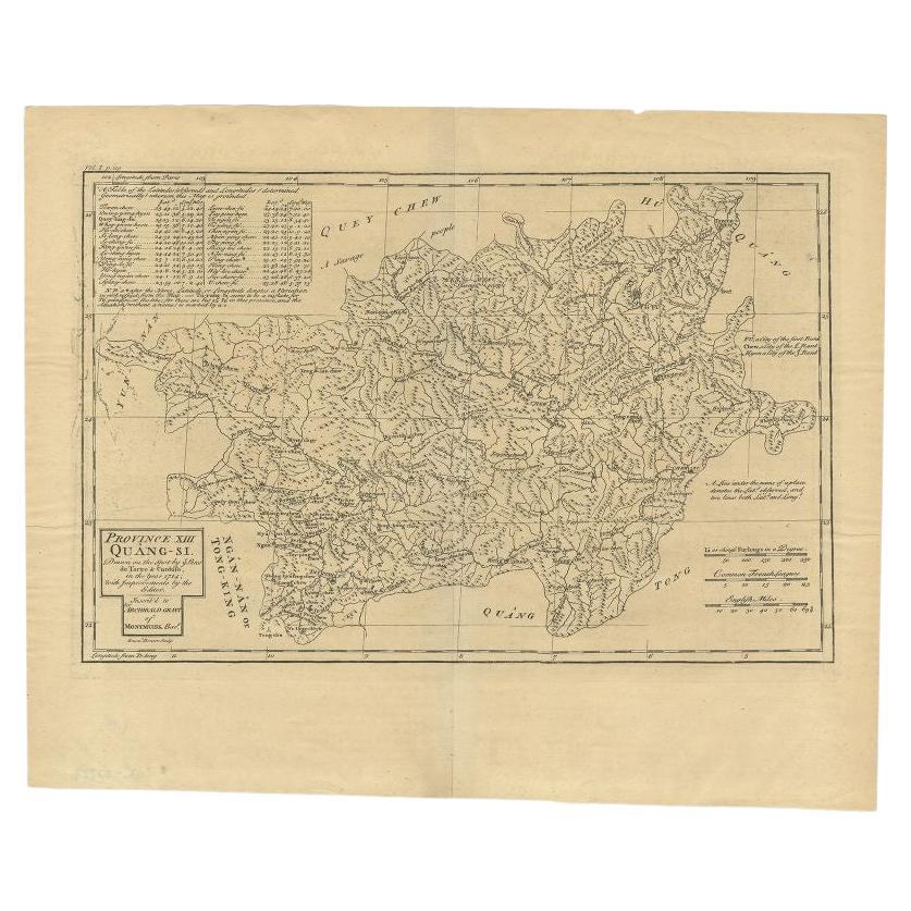
View AllAntique Map of the Province of Quang-Si by Du Halde, 1738
Located in Langweer, NL
Antique map titled 'Province XIII Quang-Si. Drawn on the spot by ye Peres de Tartre & Cordoso in the year 1714'. Old map of the Chinese province Quang-Si. Originates from the Edward ...
Category
Antique 18th Century Maps
Materials
Paper
$244 Sale Price
20% Off
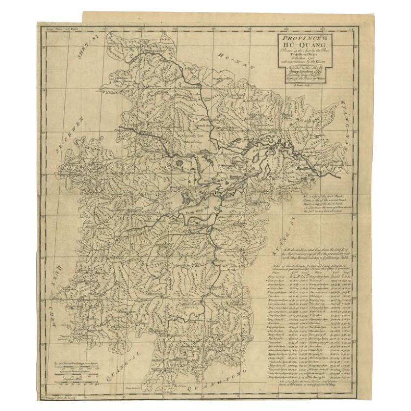
Antique Map of the Huguang Province of China by Du Halde, 1738
Located in Langweer, NL
Antique map titled 'Province VI Hu-Quang'. Old map depicting the Huguang province of China. Originates from 'A description of the Empire of China and Chinese-Tartary' by by J.B. du H...
Category
Antique 18th Century Maps
Materials
Paper
$219 Sale Price
20% Off
Antique Map of the Bay of Cordes and Surroundings by Hawkesworth, 1774
Located in Langweer, NL
Antique print titled 'Baye et Havre de Cordes (..)'. Four maps on the one sheet of; Cordes Bay, Port Famine, Woods Pay, Port Gallant, Fortescue Bay, Chile based on the voyage of John...
Category
Antique 18th Century Maps
Materials
Paper
$105 Sale Price
20% Off
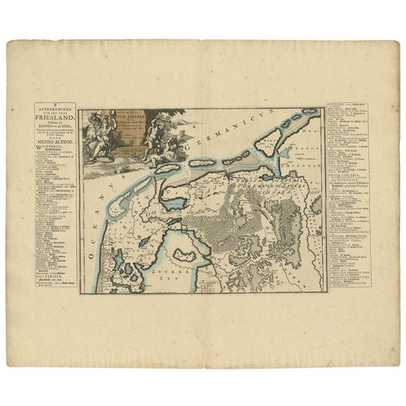
Antique Map of the Region of Kennemerland and Eems by Halma, 1718
Located in Langweer, NL
Antique map Friesland titled 'Descriptio Frisiae Liberae (..)'. Old map of Friesland, the Netherlands. This map depicts the region between Kennemerland and Eems. Originates from 'Uit...
Category
Antique 18th Century Maps
Materials
Paper
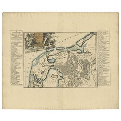
$220 Sale Price
20% Off
Antique Map of the Shanxi Province of China by Du Halde, 1738
Located in Langweer, NL
Antique map titled 'Province IX Shan-Si'. Old map depicting the Shanxi province of China. Originates from 'A description of the Empire of China and Chinese-Tartary' by J.B. du Halde....
Category
Antique 18th Century Maps
Materials
Paper
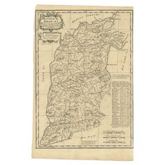
$320 Sale Price
20% Off
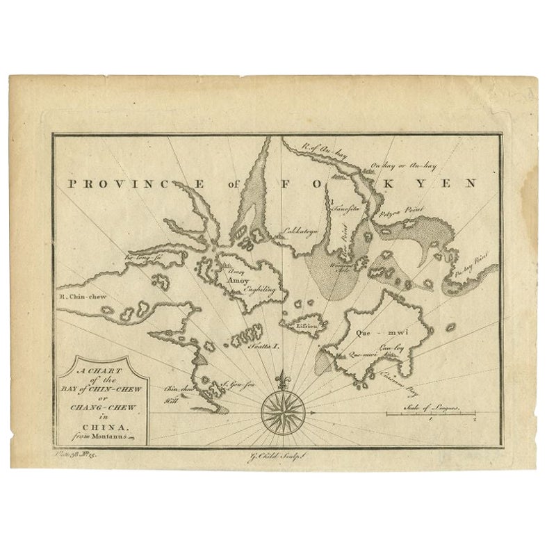
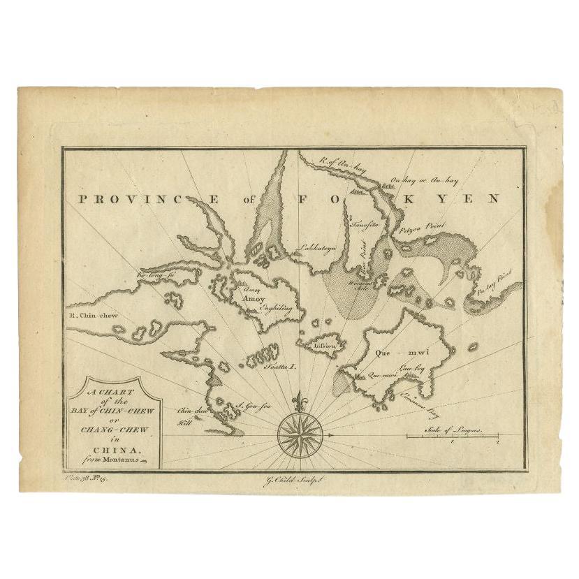
Antique Map of the Bay of Chin Chew by Child, 1747
Located in Langweer, NL
Antique map titled 'A Chart of the Bay of Chin-Chew or Chang-Chew in China'. Small but very early and interesting map, engraved by G. Child for 'The Universal Traveller', by Thomas S...
Category
Antique 18th Century Maps
Materials
Paper
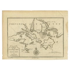
$160 Sale Price
20% Off
You May Also Like
1654 Joan Blaeu Map the Sutherland, Scotland, Entitled "Southerlandia, "Ric0007
Located in Norton, MA
1654 Joan Blaeu map of the
Sutherland, Scotland, entitled
"Southerlandia,"
Hand Colored
Ric0007
Description:
Lovely map centered on Sedan and D...
Category
Antique 17th Century Dutch Maps
Materials
Paper

1627 Hendrik Hondius Map Entitled "Vltoniae Orientalis Pars, " Ric.a009
Located in Norton, MA
1627 Hendrik Hondius map entitled
"Vltoniae orientalis pars,"
Ric.a009
Title:
Vltoniae orientalis : pars
Title (alt.) :
Ultoniae orientalis pars
Creator:
Mercator, Gerh...
Category
Antique 17th Century Dutch Maps
Materials
Paper

1646 Jansson Map Entitled "Procinvia Connactiae, " Ric.a006
Located in Norton, MA
1646 Jansson map entitled
"Procinvia connactiae,"
Ric.a006
Description: The PROVINCE of CONNAVGT 490 x 380From vol 4 of Jansson's Atlas Novus 1646, published in Amsterdam with...
Category
Antique 17th Century Unknown Maps
Materials
Paper

Original Antique Map of Switzerland, Engraved By Barlow, Dated 1807
Located in St Annes, Lancashire
Great map of Switzerland
Copper-plate engraving by Barlow
Published by Brightly & Kinnersly, Bungay, Suffolk.
Dated 1807
Unframed.
Category
Antique Early 1800s English Maps
Materials
Paper

1752 Vaugoundy Map of Flanders : Belgium, France, and the Netherlands, Ric.a002
Located in Norton, MA
Large Vaugoundy Map of Flanders:
Belgium, France, and the Netherlands
Colored -1752
Ric.a002
Description: This is a 1752 Didier Robert de Vaugondy map of Flanders. The map de...
Category
Antique 17th Century Unknown Maps
Materials
Paper

1640 Joan Bleau Map Entitled"Diocecese de rheims et le pais de rethel, " Eic.a011
Located in Norton, MA
1640 Joan Bleau map entitled
"Diocecese de rheims et le pais de rethel,"
Ric.a011
OAN BLAEU
Diocecese de Rheims, et le pais de Rethel.
Handcolored engraving, c.1640.
...
Category
Antique 17th Century Dutch Maps
Materials
Paper

More Ways To Browse
Antique Furniture Kingston
Antique Louisiana Map
Armenia Map
L Tardieu
Chinese Wall Pocket
18th Century Nautical Engraving
Antique Map Burgundy
Antique Map By Coronelli
Antique Maps Singapore
Constantinople Map
Iraq Map
Mughal Map
Map Of Palestine
Victorian Portico
Antique Furniture Dundee
Antique Map Iceland
Antique Maps Of Malta
Antique Saudi Arabia