Items Similar to Antique Map of the Region of Fréjus, France
Want more images or videos?
Request additional images or videos from the seller
1 of 6
Antique Map of the Region of Fréjus, France
$281.19
$401.6930% Off
£210.77
£301.0930% Off
€238
€34030% Off
CA$386.30
CA$551.8630% Off
A$431.27
A$616.1030% Off
CHF 225.98
CHF 322.8330% Off
MX$5,279.16
MX$7,541.6530% Off
NOK 2,869.93
NOK 4,099.9030% Off
SEK 2,705.98
SEK 3,865.6830% Off
DKK 1,811.74
DKK 2,588.2030% Off
Shipping
Retrieving quote...The 1stDibs Promise:
Authenticity Guarantee,
Money-Back Guarantee,
24-Hour Cancellation
About the Item
Title: "Golf de Fréjus"
Description: This antique map, titled "Golf de Fréjus," is an original depiction of the region of Fréjus, France. It is part of the work "Le Petit Atlas Maritime," authored by J.N. Bellin and published in 1764. The map provides a detailed representation of the Gulf of Fréjus, offering valuable geographical information about the coastal area and its surrounding features. It serves as a historical reference to the geography of the region during the 18th century.
Bellin was an important maker of charts for the French Depot de la Marine. He was born in Paris in 1703 and educated as an engineer. He produced many important charts and published them individually and in compilations. The Neptune Francais was published in 1753 and the Hydrographie Francaise in 1756. His largest and most comprehensive work is the Petit Atlas Maritime.
- Dimensions:Height: 12.49 in (31.7 cm)Width: 8.98 in (22.8 cm)Depth: 0.02 in (0.5 mm)
- Materials and Techniques:
- Period:
- Date of Manufacture:1764
- Condition:General age-related toning. Light creasing. Minor wear and soiling, blank verso. Please study image carefully.
- Seller Location:Langweer, NL
- Reference Number:Seller: BG-13397-31stDibs: LU3054333644912
About the Seller
5.0
Recognized Seller
These prestigious sellers are industry leaders and represent the highest echelon for item quality and design.
Platinum Seller
Premium sellers with a 4.7+ rating and 24-hour response times
Established in 2009
1stDibs seller since 2017
2,511 sales on 1stDibs
Typical response time: <1 hour
- ShippingRetrieving quote...Shipping from: Langweer, Netherlands
- Return Policy
Authenticity Guarantee
In the unlikely event there’s an issue with an item’s authenticity, contact us within 1 year for a full refund. DetailsMoney-Back Guarantee
If your item is not as described, is damaged in transit, or does not arrive, contact us within 7 days for a full refund. Details24-Hour Cancellation
You have a 24-hour grace period in which to reconsider your purchase, with no questions asked.Vetted Professional Sellers
Our world-class sellers must adhere to strict standards for service and quality, maintaining the integrity of our listings.Price-Match Guarantee
If you find that a seller listed the same item for a lower price elsewhere, we’ll match it.Trusted Global Delivery
Our best-in-class carrier network provides specialized shipping options worldwide, including custom delivery.More From This Seller
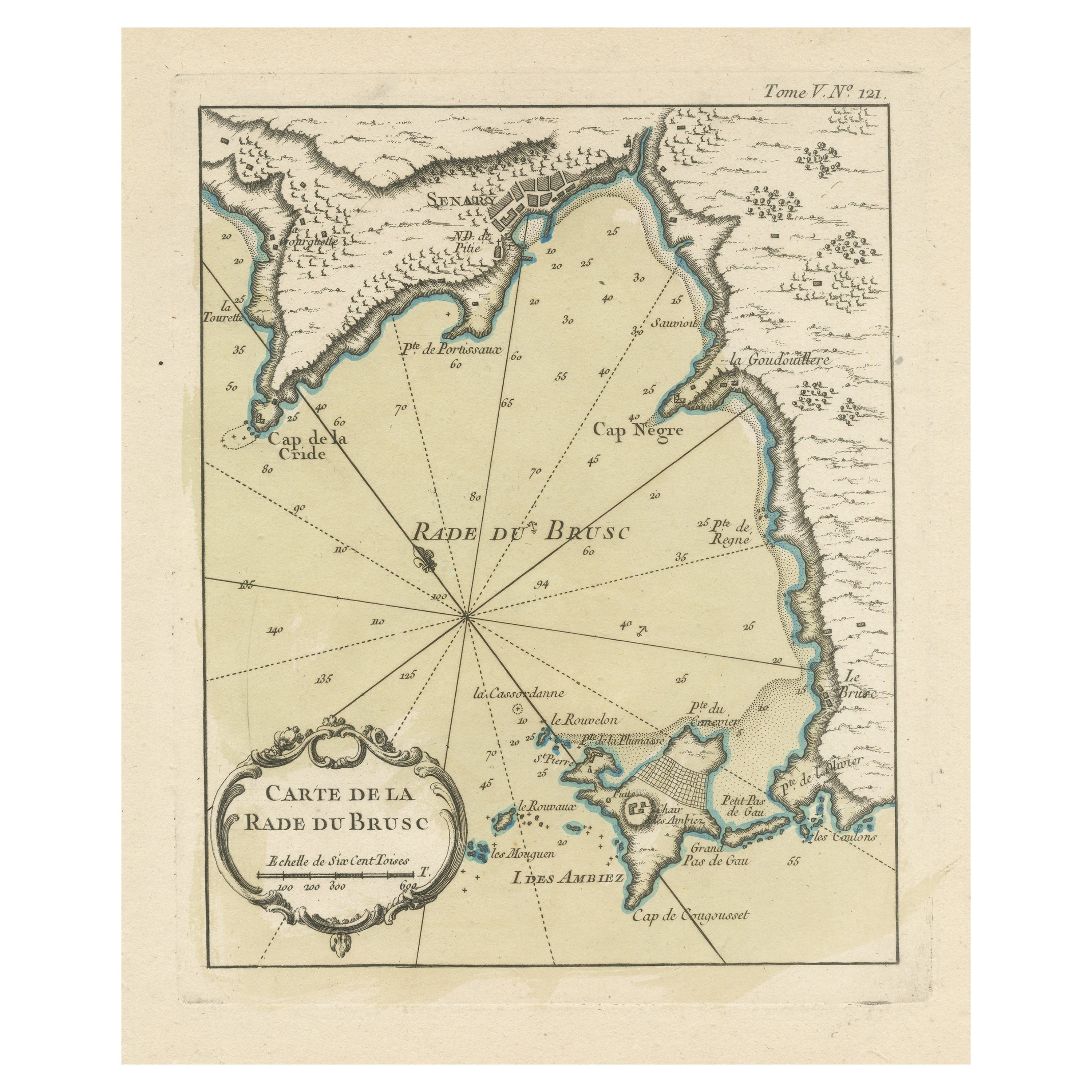
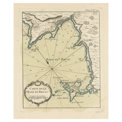
View AllAntique Map of the Bay of Brusc, France
Located in Langweer, NL
Antique map titled 'Carte de la rade du Brusc'. Original map of the bay of Brusc, France. This map originates from 'Le Petit Atlas Maritime (..)' by J.N. Bellin. Published 1764.
...
Category
Antique Mid-18th Century Maps
Materials
Paper
$321 Sale Price
20% Off
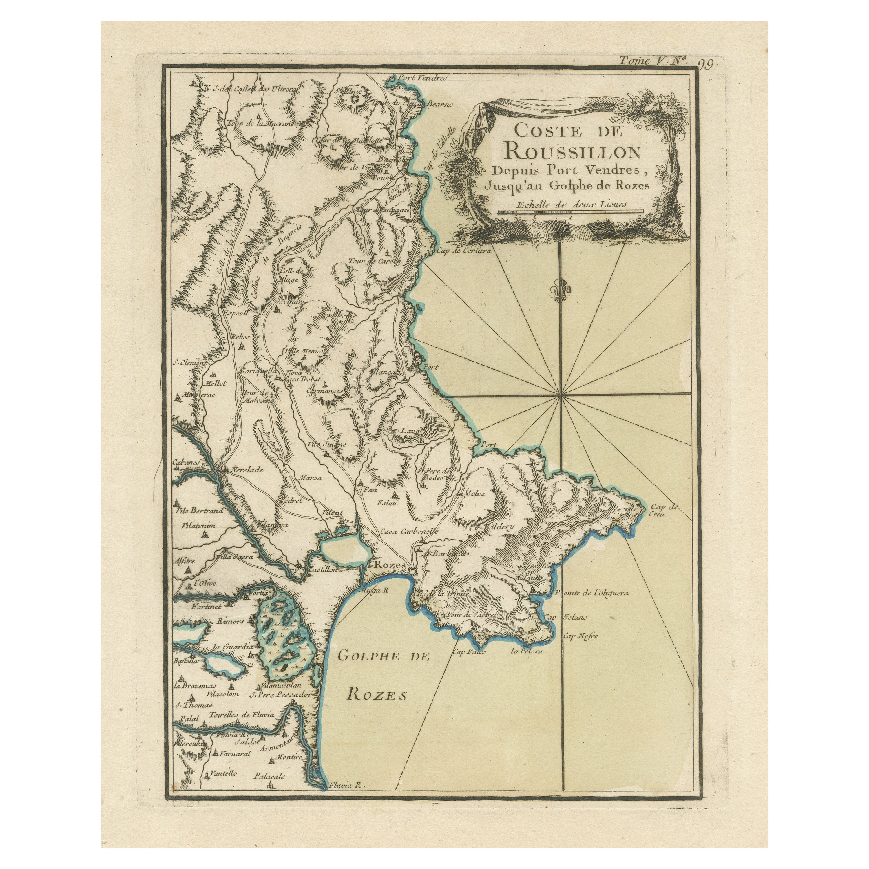
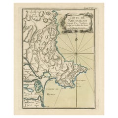
Antique Map of the Coast of Roussillon, France
Located in Langweer, NL
Antique map titled 'Coste de Roussillon depuis Port Vendres, jusqu'au golphe de Rozes'. Original map of the coast of Roussillon, France. This map originates from 'Le Petit Atlas Mari...
Category
Antique Mid-18th Century Maps
Materials
Paper
$321 Sale Price
20% Off
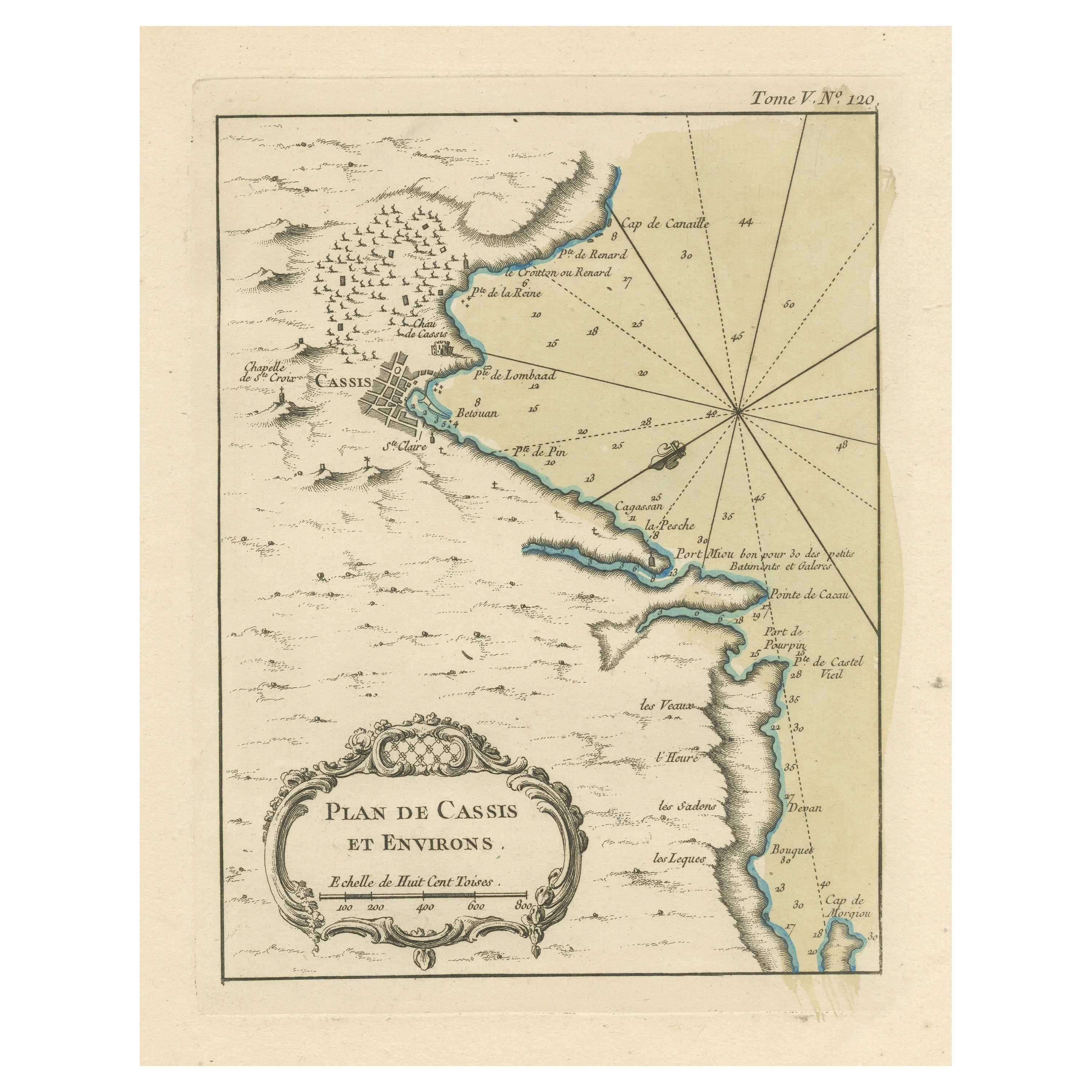
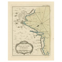
Antique Plan of the Region of Cassis, France
Located in Langweer, NL
Antique map titled 'Plan de Cassis et environs'. Original plan of the region of Cassis, France. This map originates from 'Le Petit Atlas Maritime (..)' by J.N. Bellin. Published 1764...
Category
Antique Mid-18th Century Maps
Materials
Paper
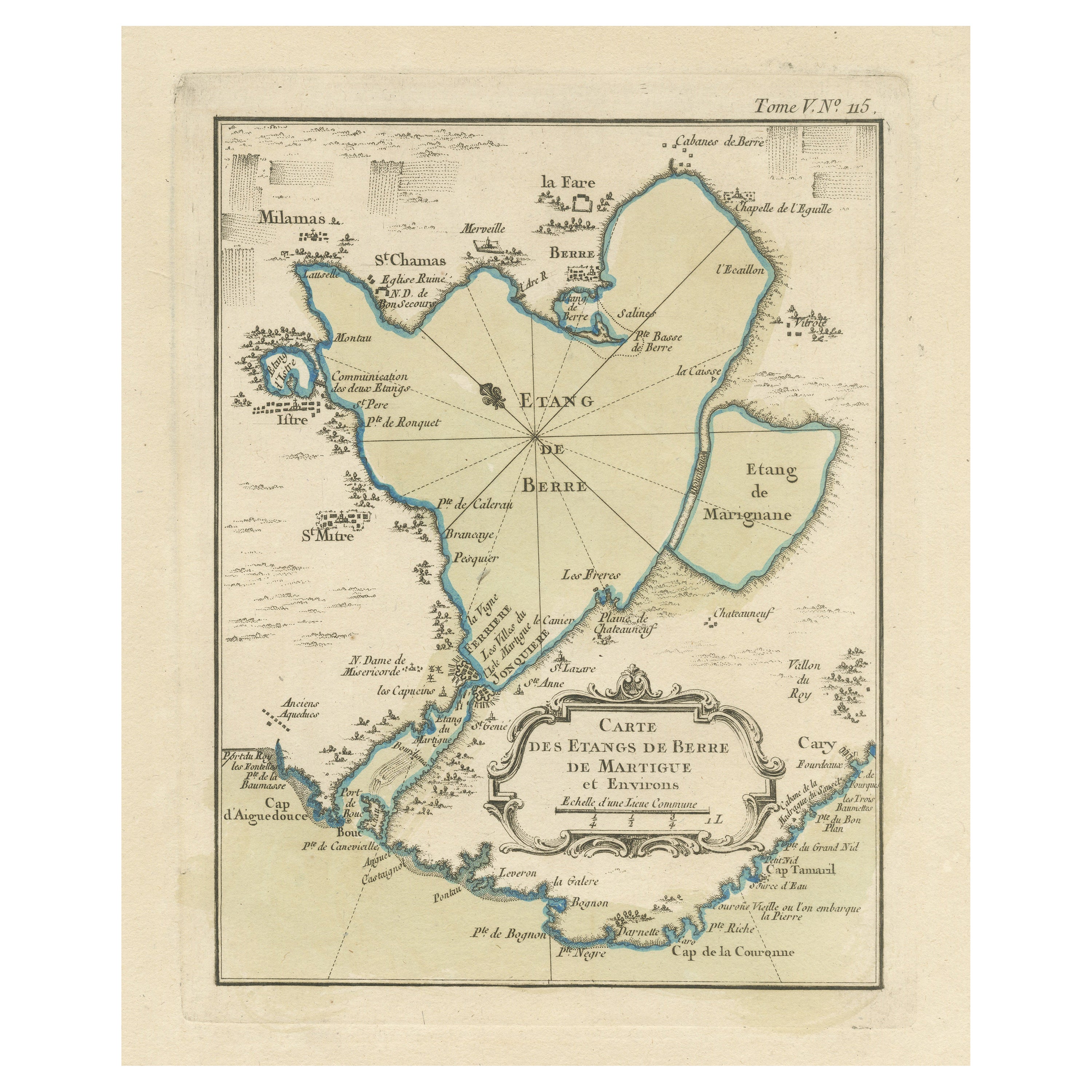
Antique Map of the Region of Berre-l'Étang, France
Located in Langweer, NL
Antique map titled 'Carte des etangs de Berre de Martigue et environs'. Original map of the region of Berre-l'Étang, France. This map originates from 'Le Petit Atlas Maritime (..)' b...
Category
Antique Mid-18th Century Maps
Materials
Paper
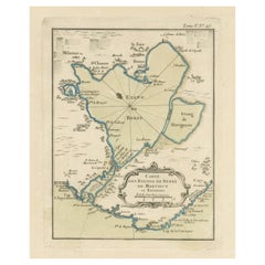
$321 Sale Price
20% Off
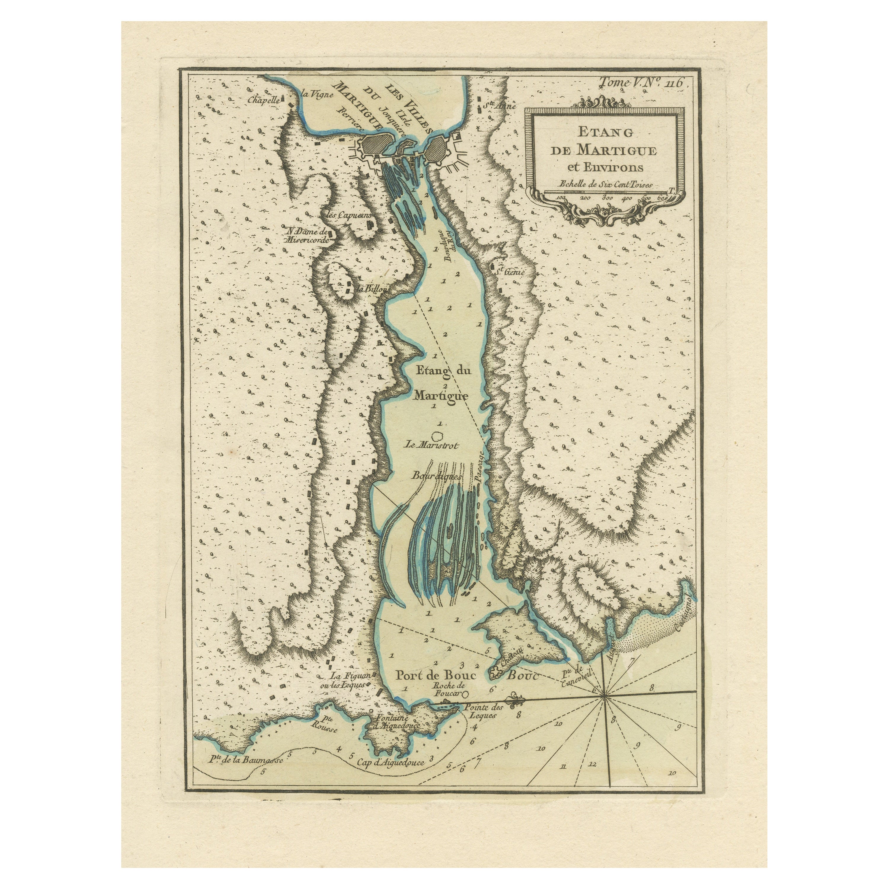
Antique Map of the Region of Martigues, France
Located in Langweer, NL
Title: "Etang de Martigues et Environs: Antique Map of the Martigues Region, France"
Description: This antique map, titled "Etang de Martigue et Environs," offers a detailed view of...
Category
Antique Mid-18th Century Maps
Materials
Paper
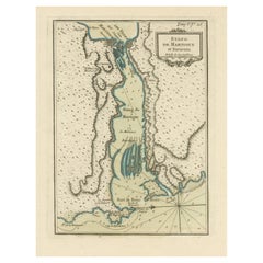
$321 Sale Price
20% Off
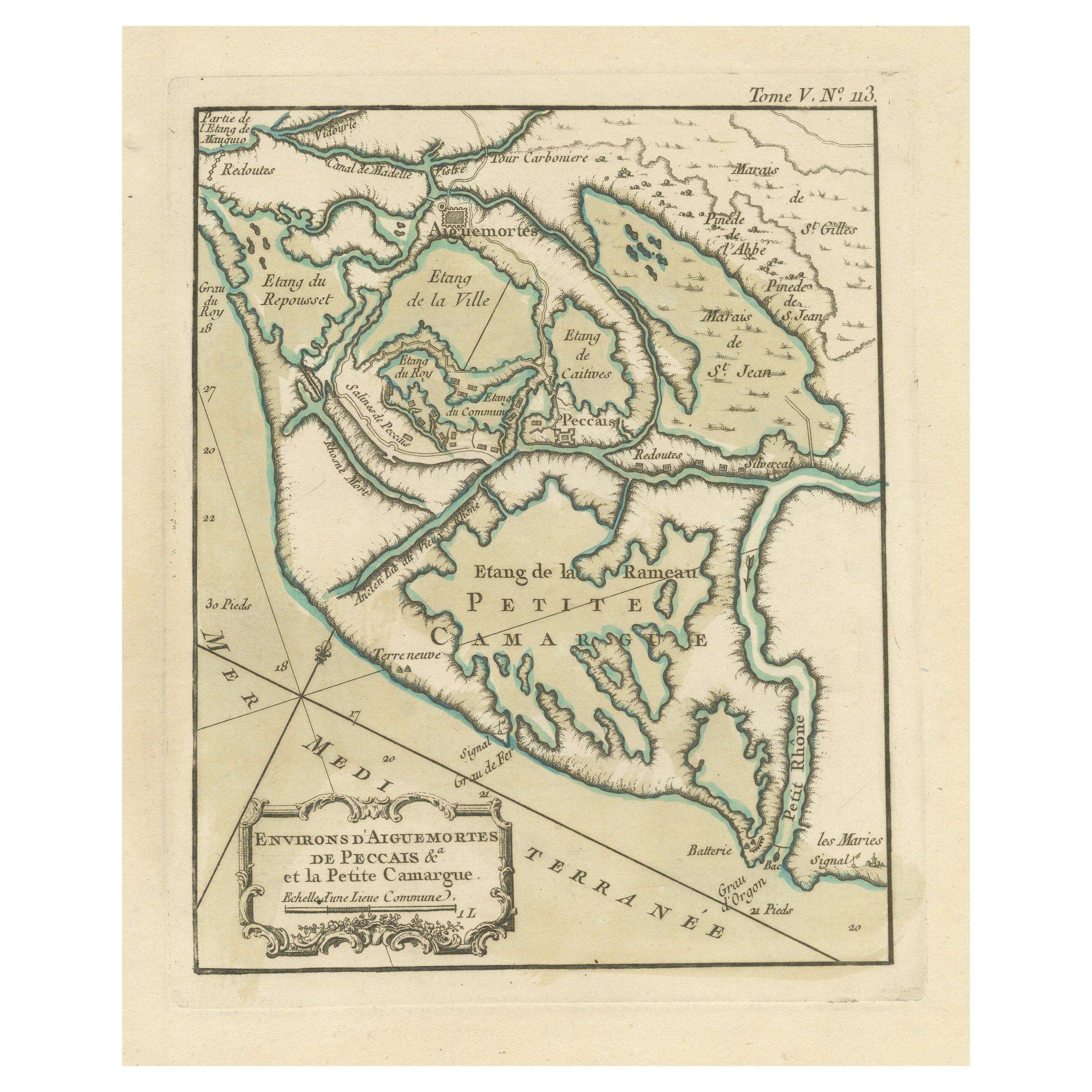
Antique Map of the Region of Aigues-Mortes and Camargue, France
Located in Langweer, NL
Antique map titled 'Environs d'Aiguemortes de Peccais &a et la petite Camargue'. Original map of the region of Aigues-Mortes and Camargue, France. This map originates from 'Le Petit ...
Category
Antique Mid-18th Century Maps
Materials
Paper
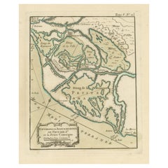
$321 Sale Price
20% Off
You May Also Like
1590 Ortelius Map of Calais and Vermandois, France and Vicinity Ric.a014
Located in Norton, MA
1590 Ortelius map of
Calais and Vermandois, France and Vicinity
Ric.a014
Two rare regional Abraham Ortelius maps on a single folio sheet. Left map, entitled Caletensium, depic...
Category
Antique 16th Century Dutch Maps
Materials
Paper

1771 Bonne Map of Poitou, Touraine and Anjou, France, Ric.a015
Located in Norton, MA
1771 Bonne Map of Poitou,
Touraine and Anjou, France
Ric.a015
1771 Bonne map of Potiou, Touraine and Anjou entitled "Carte des Gouvernements D'Anjou et du Saumurois, de la Touraine, du Poitou,du Pays d'aunis, Saintonge?Angoumois,"
Carte des gouvernements d'Anjou et du Saumurois, de la Touraine, du Poitou, du Pays d'Aunis, Saintonge-Angoumois. Projettee et assujettie au ciel par M. Bonne, Hyd. du Roi. A Paris, Chez Lattre, rue St. Jacques a la Ville de Bord(ea)ux. Avec priv. du Roi. 1771. Arrivet inv. & sculp., Atlas moderne ou collection de cartes sur toutes...
Category
Antique 17th Century Unknown Maps
Materials
Paper

1633 Map "La Souverainete De Sedan Et De Raucourt, Et La Prevoste Ric0011
Located in Norton, MA
1653 map entitled
"La Souverainete de Sedan et de Raucourt, et la Prevoste de Doncheri,"
Ric0011
Description:
Lovely map centered on Sedan and Doncheri and the Meuze River fr...
Category
Antique 17th Century Dutch Maps
Materials
Paper

The Normandy Region of France: A 17th C. Hand-colored Map by Sanson and Jaillot
By Nicolas Sanson
Located in Alamo, CA
This large hand-colored map entitled "Le Duché et Gouvernement de Normandie divisée en Haute et Basse Normandie en divers Pays; et par evêchez, avec le Gouvernement General du Havre ...
Category
Antique 1690s French Maps
Materials
Paper

1590 Mercator Map Entitled "France Picardie Champaigne, Ric.0001
Located in Norton, MA
Description: Published in Amsterdam by Mercator/Hondius ca. 1590.
Ric.0001
Artists and Engravers: Map : 'France Picardie Champaigne cum regionibus adiacentibus'. (Map of the french provinces of Picardie and Champagne.) Copper engraved map of the french provinces of Picardie and Champagne, showing the cities of Caen, Paris, Melun, Auxerre, Verdun, etc. Copperplate engraving on verge type hand laid paper with watermark. Description: Published in Amsterdam by Mercator/Hondius ca. 1600.Artists and Engravers: Mercator was born in Rupelmonde in Flanders and studied in Louvain under Gemma Frisius, Dutch writer, astronomer and mathematician. The excellence of his work brought him the patronage of Charles V, but in spite of his favor with the Emperor he was caught up in the persecution of Lutheran protestants and charged with heresy, fortunately without serious consequences. No doubt the fear of further persecution influenced his move in 1552 to Duisburg, where he continued the production of maps, globes and instruments. Mercator's sons and grandsons, were all cartographers and made their contributions in various ways to his atlas. Rumold, in particular, was responsible for the complete edition in 1595. The map plates...
Category
Antique 16th Century Dutch Maps
Materials
Paper

1656 Jansson Map Metz Region of France Entitled "Territorium Metense" Ric0014
Located in Norton, MA
1656 Jansson map Metz Region of France entitled "Territorium Metense."
Ric0014
" Authentic" - Map of the historical region surrounding Metz, in Lorraine, France.
Oriented with ...
Category
Antique 17th Century Dutch Maps
Materials
Paper

More Ways To Browse
Antique Golf Collectables
Lancashire Map
Maltese Falcon
Raised Relief Map
William Dampier
Antique Chesapeake Bay Map
Astrology Map
Mauritius Antique Map
Oman Map
Tanzania Antique Map
Georgetown Map
Nova Hollandia
Aden Yemen
Antique Map Of Republic Of Texas
Miliens S
Sumba Map
1681 Moses Pitt
Antique Maps Washington Dc