Items Similar to Antique Map of the Roadstead of Batavia by Van der Aa, 1725

Want more images or videos?
Request additional images or videos from the seller
1 of 5
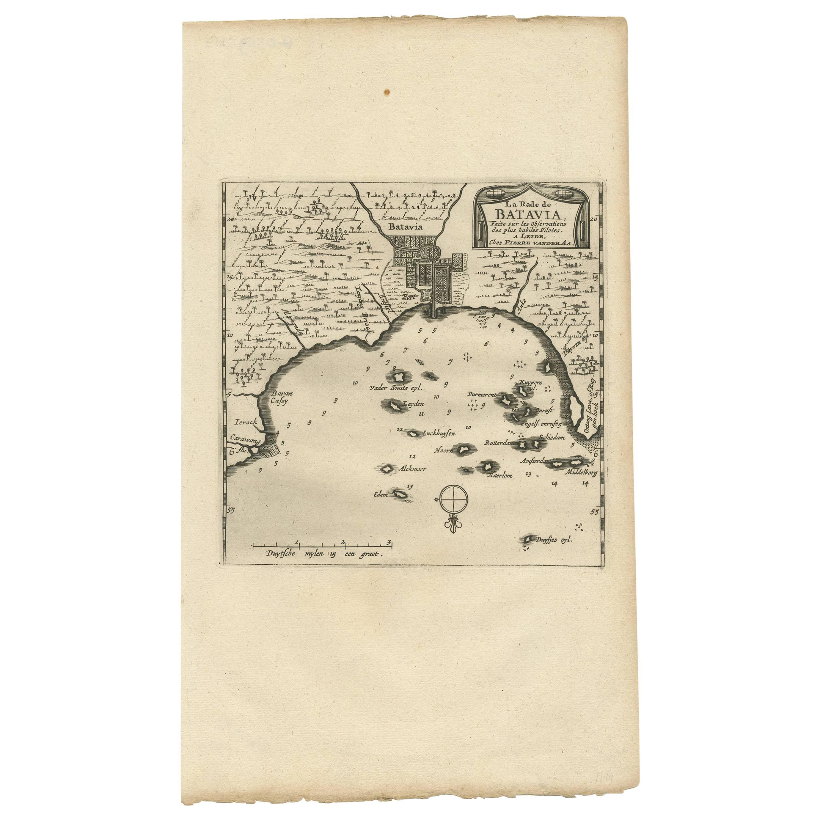
Antique Map of the Roadstead of Batavia by Van der Aa, 1725
$287.10
$358.8820% Off
£216.53
£270.6620% Off
€246.40
€30820% Off
CA$396.95
CA$496.1820% Off
A$444.65
A$555.8120% Off
CHF 233.54
CHF 291.9320% Off
MX$5,406.75
MX$6,758.4320% Off
NOK 2,957.43
NOK 3,696.7920% Off
SEK 2,807.40
SEK 3,509.2420% Off
DKK 1,875.76
DKK 2,344.7020% Off
About the Item
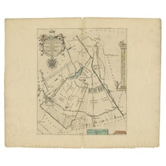
Antique map titled 'La rade de Batavia'. (The roadstead of Batavia.) This map shows the roadstead before the Indonesian city of Batavia, nowadays Jakarta. This plate originates from the very scarse: 'La galerie agreable du monde'. Tome premier des Indes Orientales.', published by P. van der Aa, Leyden, c. 1725. This famous work was published in 66 parts and is the biggest print / map book ever published. Van der Aa incorporated plates by other publishers such as Blaeu, Visscher, de Wit, meurs, Halma, Mortier, Allard in this work and often added broad decorative borders. Probably the costliest and complete universal geographic work ever produced. It is said that only 100 copies were printed. Ref: Koeman Aa9; Phillips 2780 note.
Artists and Engravers: Pieter van der Aa (Leiden 1659-1733) was a Dutch publisher best known for preparing maps and atlases. The Galerie Agreable contains plates and maps by the best Dutch engravers: Luiken, Goeree, Mulder, Stoopendaal, ao.
Condition: Good, General age related toning and occasional light staining from handling. Paper edge uncut and thus irregular. Original middle fold as issued. Please study image carefully.
Date: 1725
Overall size: 49 x 38 cm.
Image size: 15.5 x 16 cm.
We sell original antique maps to collectors, historians, educators and interior decorators all over the world. Our collection includes a wide range of authentic antique maps from the 16th to the 20th centuries. Buying and collecting antique maps is a tradition that goes back hundreds of years. Antique maps have proved a richly rewarding investment over the past decade, thanks to a growing appreciation of their unique historical appeal. Today the decorative qualities of antique maps are widely recognized by interior designers who appreciate their beauty and design flexibility. Depending on the individual map, presentation, and context, a rare or antique map can be modern, traditional, abstract, figurative, serious or whimsical. We offer a wide range of authentic antique maps for any budget.
- Creator:Pieter Van Der Aa (Artist)
- Dimensions:Height: 14.97 in (38 cm)Width: 19.3 in (49 cm)Depth: 0 in (0.01 mm)
- Materials and Techniques:
- Period:
- Date of Manufacture:1725
- Condition:
- Seller Location:Langweer, NL
- Reference Number:Seller: PCT-212781stDibs: LU3054327912832
Pieter Van Der Aa
Pieter van der Aa began his career at Leiden in 1683 as a Latin trade publisher, publishing classical texts about medicine and science. He was a Dutch publisher of maps and atlases active in the late 17th and early 18th centuries. During his long and impressive career, Van der Aa produced thousands of maps, including a vast 28 volume atlas containing no less than 3,000 maps.
About the Seller
5.0
Recognized Seller
These prestigious sellers are industry leaders and represent the highest echelon for item quality and design.
Platinum Seller
Premium sellers with a 4.7+ rating and 24-hour response times
Established in 2009
1stDibs seller since 2017
2,517 sales on 1stDibs
Typical response time: <1 hour
- ShippingRetrieving quote...Shipping from: Langweer, Netherlands
- Return Policy
Authenticity Guarantee
In the unlikely event there’s an issue with an item’s authenticity, contact us within 1 year for a full refund. DetailsMoney-Back Guarantee
If your item is not as described, is damaged in transit, or does not arrive, contact us within 7 days for a full refund. Details24-Hour Cancellation
You have a 24-hour grace period in which to reconsider your purchase, with no questions asked.Vetted Professional Sellers
Our world-class sellers must adhere to strict standards for service and quality, maintaining the integrity of our listings.Price-Match Guarantee
If you find that a seller listed the same item for a lower price elsewhere, we’ll match it.Trusted Global Delivery
Our best-in-class carrier network provides specialized shipping options worldwide, including custom delivery.More From This Seller
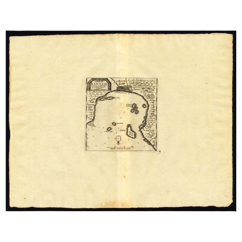
View AllAntique Map of the Roadstead of Bantam by Van der Aa, 1725
By Pieter Van Der Aa
Located in Langweer, NL
Antique map titled 'La rade de Bantam'. (The roadstead of Bantam.) This map shows the Indonesian city of Banten / Bantam on Java, Indonesia and its roadstead. With compass rose and s...
Category
Antique 18th Century Maps
Materials
Paper
$245 Sale Price
20% Off
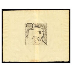
Antique Map of the Bay of Batavia by Van der Aa, c.1720
Located in Langweer, NL
Antique map titled 'La Rade de Batavia'. A small early 18th century black and white map of the Bay of Batavia (Jakarta), Indonesia. Published by P....
Category
Antique 18th Century Maps
Materials
Paper

$251 Sale Price
20% Off
Antique Map of Batavia, Jakarta, Indonesia by P. Van Der Aa, 1719
Located in Langweer, NL
A small early 18th century black and white map of Batavia by the Dutch cartographer Pieter Van Der Aa. This map was first published in his 'Nouvel ...
Category
Antique Early 18th Century Prints
Materials
Paper

$340 Sale Price
20% Off
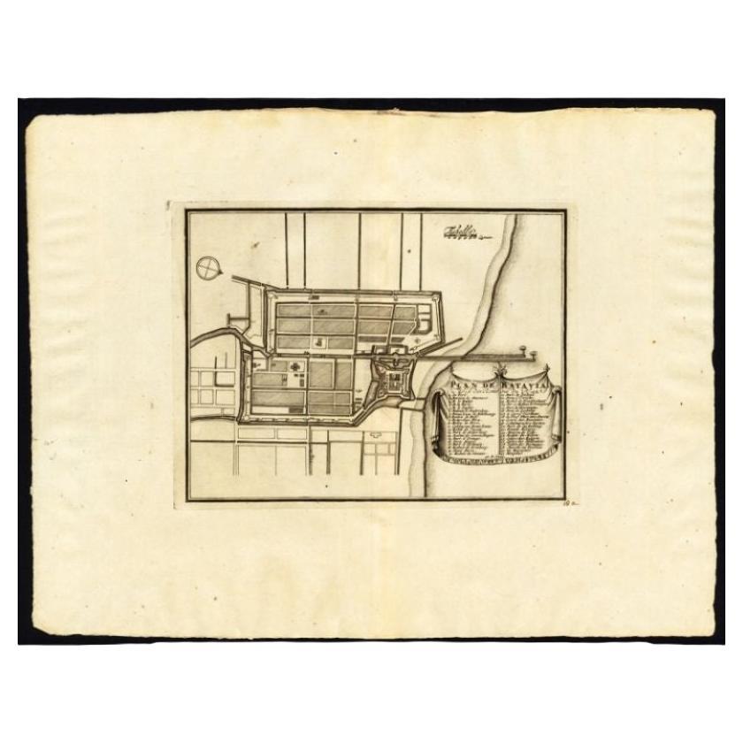
Antique Plan of Batavia, Capital of the Dutch East Indies, by Van Der Aa, 1725
By Pieter Van Der Aa
Located in Langweer, NL
Antique map titled 'Plan de Batavia'. (Plan of Batavia.) This plate shows a plan of the city of Batavia / Jakarta in Indonesia. With extensive legend, compass rose and scale. This pl...
Category
Antique 18th Century Maps
Materials
Paper

$531 Sale Price
20% Off
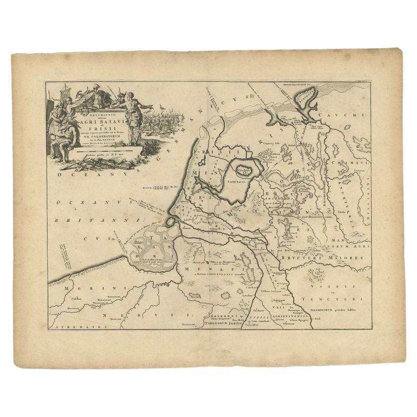
Antique Map of the Old Land of Batavia and FriesLand, The Netherlands, 1697
Located in Langweer, NL
Antique map Friesland titled 'Descriptio veteris Agri Batavi et Frisii (..)'. Old map of Friesland, the Netherlands. Depicts the old land of Batavia and Friesland. This map originate...
Category
Antique 17th Century Maps
Materials
Paper
$176 Sale Price
20% Off
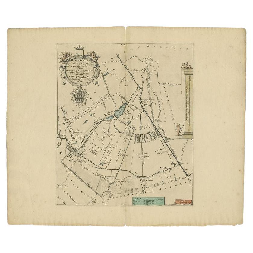
Antique Map of the Haskerland Township 'Friesland' by Halma, 1718
Located in Langweer, NL
Antique map Friesland titled 'Haskerland, de vierde Grietenije van de Zevenwolden (..)'. Old map of Friesland, the Netherlands. This map depicts the region of Haskerland and includes...
Category
Antique 18th Century Maps
Materials
Paper
$330 Sale Price
20% Off
You May Also Like
1646 Jansson Map Entitled "Procinvia Connactiae, " Ric.a006
Located in Norton, MA
1646 Jansson map entitled
"Procinvia connactiae,"
Ric.a006
Description: The PROVINCE of CONNAVGT 490 x 380From vol 4 of Jansson's Atlas Novus 1646, published in Amsterdam with...
Category
Antique 17th Century Unknown Maps
Materials
Paper

The Holy Land at the Time of Jesus: A 17th Century Dutch Map by Visscher
By Nicolaes Visscher II
Located in Alamo, CA
This detailed Dutch map entitled "Het Beloofe de Landt Canaan door wandelt van onsen Salichmaecker Iesu Christo, nessens syne Apostelen" by Nicolaes Visscher was published in Amsterd...
Category
Antique Mid-17th Century Dutch Maps
Materials
Paper

1718 Ides & Witsen Map "Route D'amsterdam a Moscow Et De La Ispahan Et Gamron
Located in Norton, MA
1718 Ides & Witsen map, entitled
"Route D'Amsterdam A Moscow Et De La Ispahan Et Gamron,"
Ric.b005
Subject: Eastern Europe and Central Asia
Period: 1718 (published)
Publicati...
Category
Antique Early 18th Century Dutch Maps
Materials
Paper

1620 Map of Artois Entitled "Artesia Comitatvs Artois, " by Bleau, Ric.a012
Located in Norton, MA
1640 map of Artois entitled
"Artesia Comitatvs Artois,"
by Bleau
Colored
A-012.
Detailed map of the northern province of Artois, France on the border with Belgium. Feature...
Category
Antique 17th Century Dutch Maps
Materials
Paper

1627 Hendrik Hondius Map Entitled "Vltoniae Orientalis Pars, " Ric.a009
Located in Norton, MA
1627 Hendrik Hondius map entitled
"Vltoniae orientalis pars,"
Ric.a009
Title:
Vltoniae orientalis : pars
Title (alt.) :
Ultoniae orientalis pars
Creator:
Mercator, Gerh...
Category
Antique 17th Century Dutch Maps
Materials
Paper

1633 Map "La Souverainete De Sedan Et De Raucourt, Et La Prevoste Ric0011
Located in Norton, MA
1653 map entitled
"La Souverainete de Sedan et de Raucourt, et la Prevoste de Doncheri,"
Ric0011
Description:
Lovely map centered on Sedan and Doncheri and the Meuze River fr...
Category
Antique 17th Century Dutch Maps
Materials
Paper

More Ways To Browse
Antique Map Of Colombia
Antique Map Palestine
Vintage Wooden Roller
Antique Constellation Map
Antique Maps Of Cape Of Good Hope
Caucasus Map
Map Of Puerto Rico
Nevada Antique Map
Shetland Map
Antique Chicago Maps
Kolkata Antique Furniture
Antique Bermuda Furniture
Antique Dairy Collectibles
Antique Map Of Cuba
Antique Map Of Yorkshire
Antique Map Vietnam
Antique Maps Massachusetts
Guyana Antique Map