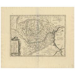
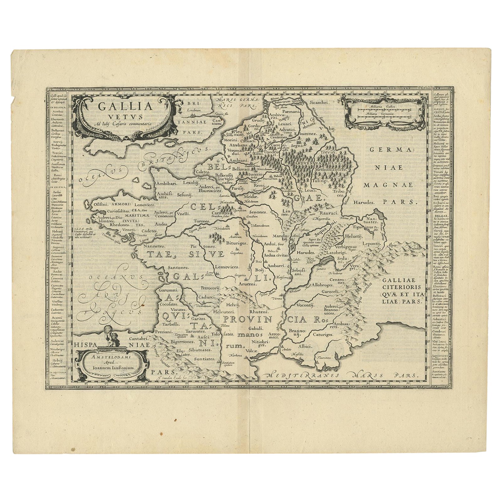
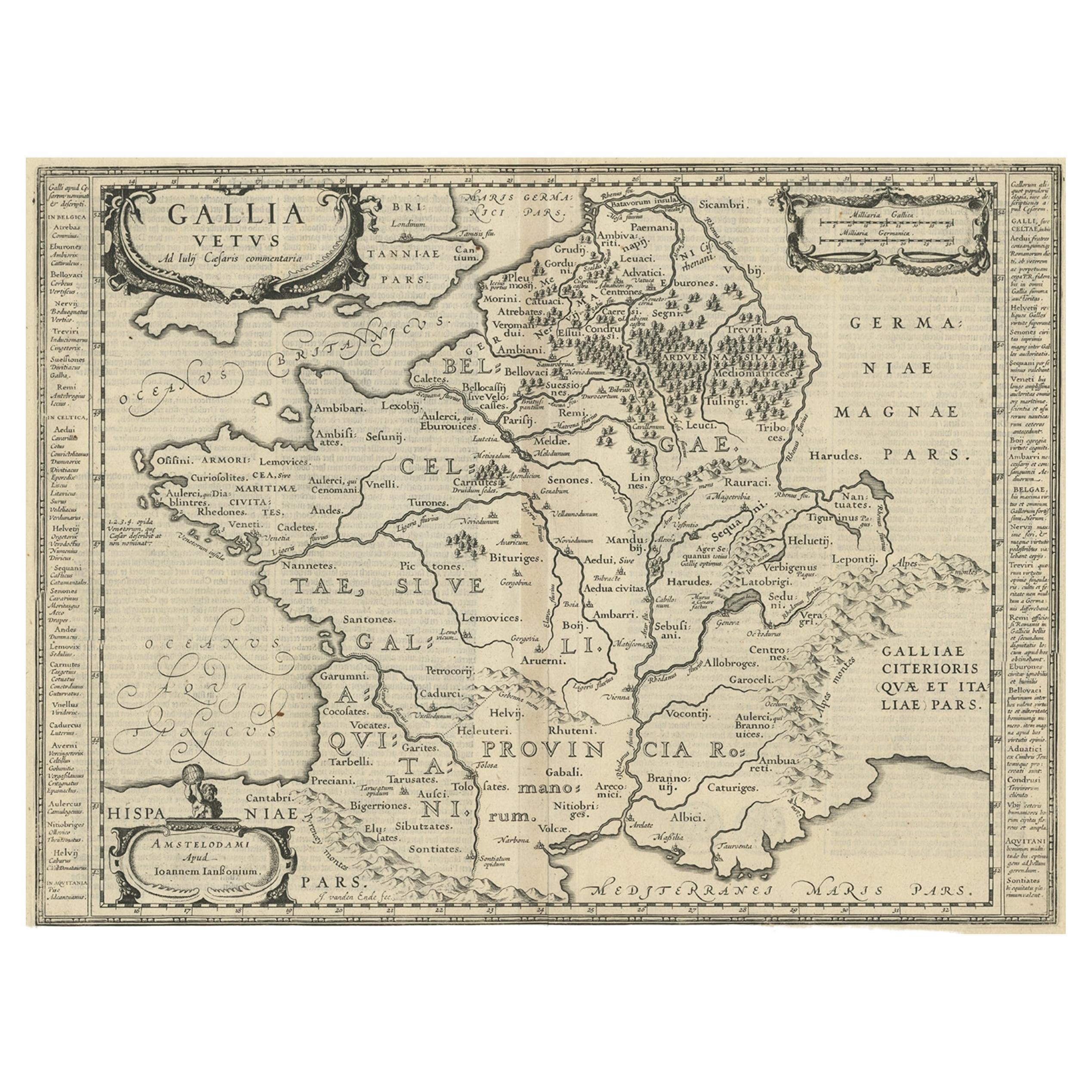
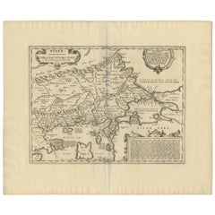
Antique Map of Romania 'Dacia & Moesia' by J. Jansson, circa 1650
View Similar Items


Want more images or videos?
Request additional images or videos from the seller
1 of 9
Antique Map of Romania 'Dacia & Moesia' by J. Jansson, circa 1650
Price:$575
$857.14List Price
About the Item
- Dimensions:Height: 20.79 in (52.8 cm)Width: 25.2 in (64 cm)Depth: 0.02 in (0.5 mm)
- Materials and Techniques:
- Period:Mid-17th Century
- Date of Manufacture:circa 1650
- Condition:Minor fading. Minor staining. Please study image carefully.
- Seller Location:Langweer, NL
- Reference Number:Seller: BG-092071stDibs: LU305439945771
About the Seller
5.0
Recognized Seller
These prestigious sellers are industry leaders and represent the highest echelon for item quality and design.
Platinum Seller
Premium sellers with a 4.7+ rating and 24-hour response times
Established in 2009
1stDibs seller since 2017
2,567 sales on 1stDibs
Authenticity Guarantee
In the unlikely event there’s an issue with an item’s authenticity, contact us within 1 year for a full refund. DetailsMoney-Back Guarantee
If your item is not as described, is damaged in transit, or does not arrive, contact us within 7 days for a full refund. Details24-Hour Cancellation
You have a 24-hour grace period in which to reconsider your purchase, with no questions asked.Vetted Professional Sellers
Our world-class sellers must adhere to strict standards for service and quality, maintaining the integrity of our listings.Price-Match Guarantee
If you find that a seller listed the same item for a lower price elsewhere, we’ll match it.Trusted Global Delivery
Our best-in-class carrier network provides specialized shipping options worldwide, including custom delivery.More From This Seller
View AllAntique Map of Greece by J. Jansson, circa 1653
Located in Langweer, NL
This is an authentic antique map of the Greece by Jan Jansson. The map was published in Amsterdam, circa 1653. This striking 17th century map of Greece was based on “Totius Graeciae ...
Category
Antique Mid-17th Century Maps
Materials
Paper

$838 Sale Price
20% Off
Antique Map of Catalonia by Blaeu, circa 1650
Located in Langweer, NL
Antique map titled 'Catalonia'. Antique map of Catalonia, extending from C. De Romani on the Northern Coast to Alfachs and Panicola in Valencia on the southern end of the coast and s...
Category
Antique Mid-17th Century Maps
Materials
Paper

$857 Sale Price
20% Off
Antique Map of Java by Janssonius, circa 1650
Located in Langweer, NL
Antique map titled 'Insulae Iavae cum parte insularum Borneo Sumatrae, et circumjacentium insularum novissima delineatio'. Beautiful map of Java and parts of Bali, Borneo, Sumatra an...
Category
Antique Mid-17th Century Maps
Materials
Paper

Antique Map of Styria by Mercator 'circa 1650'
Located in Langweer, NL
Antique map titled 'Stiria'. Original antique map of Styria, Austria. Published by G. Mercator, circa 1650.
Category
Antique Mid-17th Century Maps
Materials
Paper

$428 Sale Price
20% Off
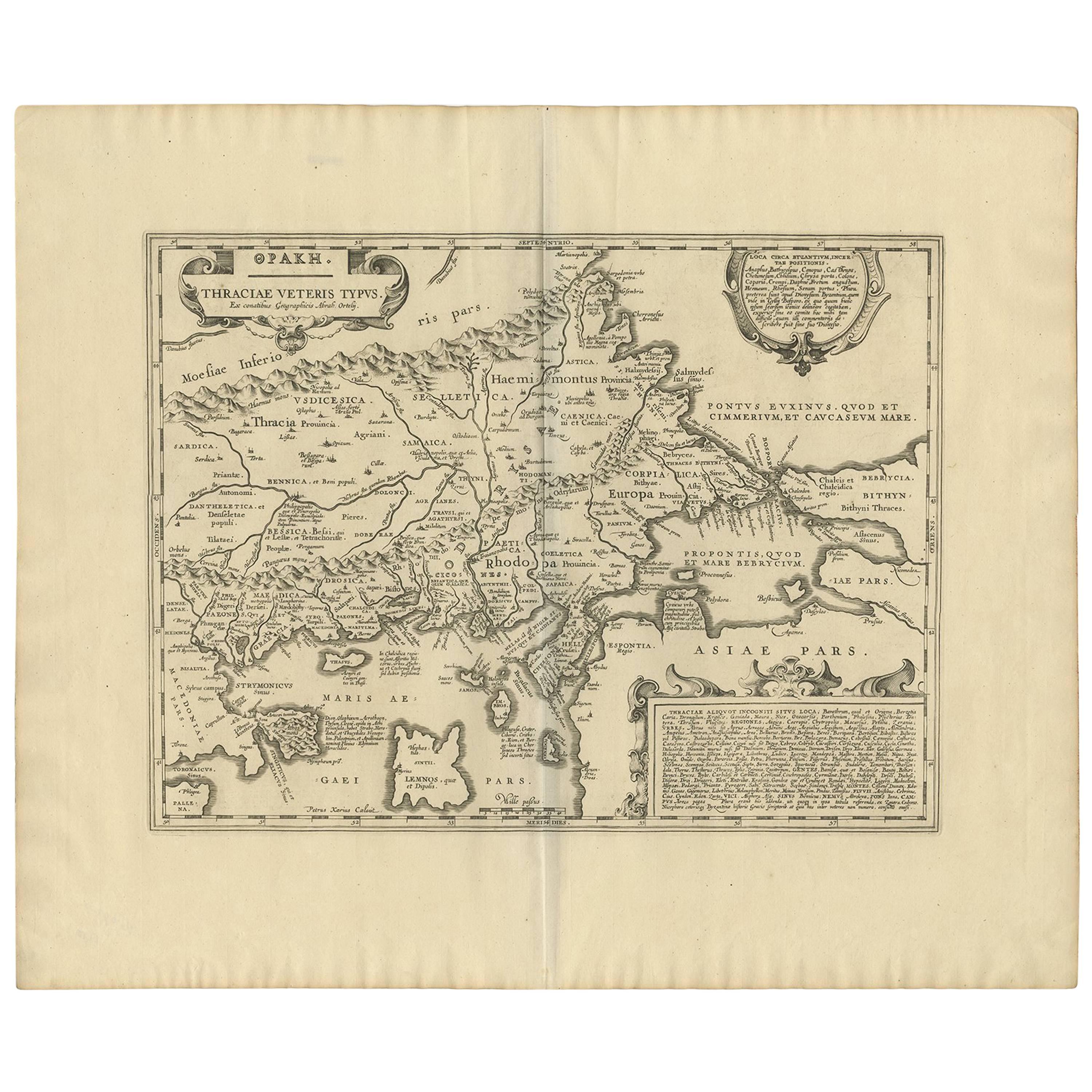
Antique Map of Thracia ‘Greece’ by J. Janssonius, circa 1650
Located in Langweer, NL
This antique map of Thracia is engraved and published by J. Janssonius after the cartographical sources by Abraham Ortelius. Ornated in the upper left corner with a title cartouche a...
Category
Antique Mid-17th Century Maps
Materials
Paper
$809 Sale Price
20% Off
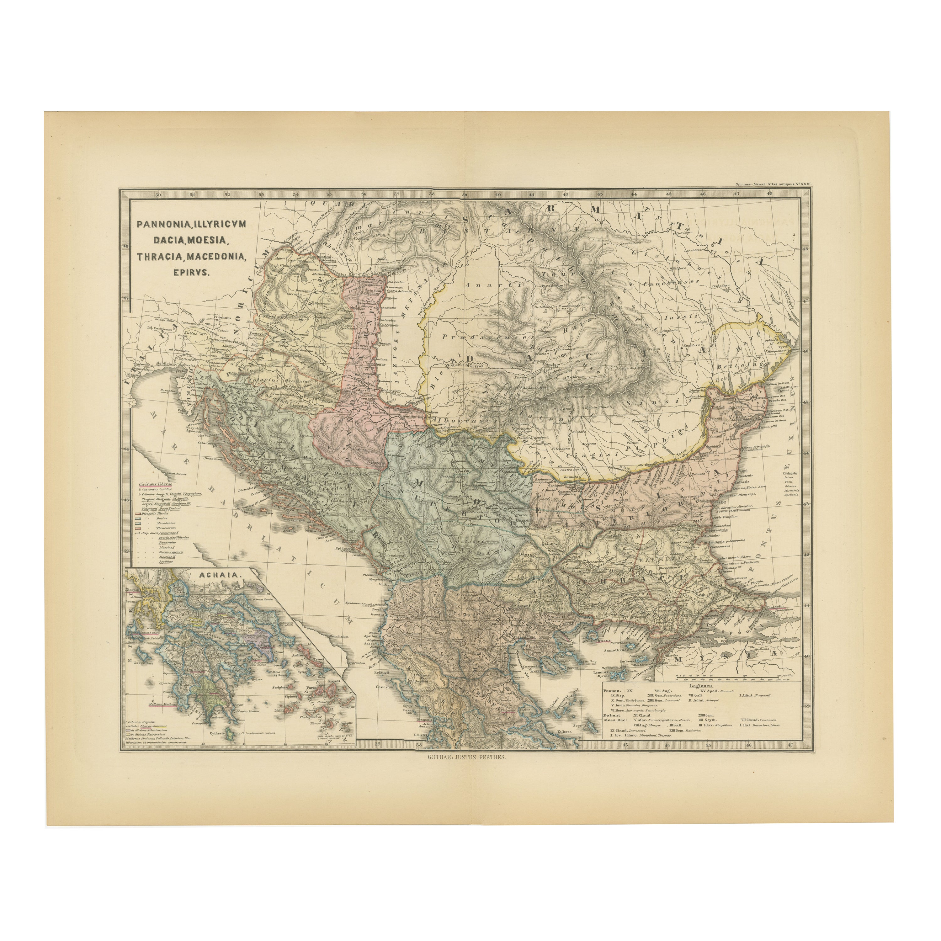
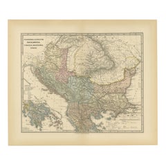
Roman Balkans: Pannonia, Illyricum, Dacia, Moesia, Thracia, Macedonia and Thyris
Located in Langweer, NL
This original antique map showcases the Roman provinces in the Balkan region and parts of Central and Eastern Europe. The title "PANNONIA, ILLYRICUM DACIA, MOESIA, THRACIA, MACEDONIA...
Category
Antique 1880s Maps
Materials
Paper
$352 Sale Price
20% Off
Free Shipping
You May Also Like
1636 Jansson Map of Ireland Entitled "Comitatus Lageniae, " Ric.a007
Located in Norton, MA
1646 Jansson map entitled
"Procinvia connactiae,"
Ric.a006
Description: The PROVINCE of CONNAVGT 490 x 380From vol 4 of Jansson's Atlas Novus 1646, published in Amsterdam with...
Category
Antique 17th Century Unknown Maps
Materials
Paper

1646 Jansson Map Entitled "Procinvia Connactiae, " Ric.a006
Located in Norton, MA
1646 Jansson map entitled
"Procinvia connactiae,"
Ric.a006
Description: The PROVINCE of CONNAVGT 490 x 380From vol 4 of Jansson's Atlas Novus 1646, published in Amsterdam with...
Category
Antique 17th Century Unknown Maps
Materials
Paper

Original Antique Map of India by Dower, circa 1835
Located in St Annes, Lancashire
Nice map of India
Drawn and engraved by J.Dower
Published by Orr & Smith. C.1835
Unframed.
Free shipping
Category
Antique 1830s English Maps
Materials
Paper

Original Antique Map of Africa by Dower, circa 1835
Located in St Annes, Lancashire
Nice map of Africa
Drawn and engraved by J.Dower
Published by Orr & Smith. C.1835
Unframed.
Free shipping
Category
Antique 1830s English Maps
Materials
Paper

Original Antique Map of Scotland by Dower, circa 1835
Located in St Annes, Lancashire
Nice map of Scotland
Drawn and engraved by J.Dower
Published by Orr & Smith. C.1835
Unframed.
Free shipping
Category
Antique 1830s English Maps
Materials
Paper

Original Antique Map of Australia by Dower, circa 1835
Located in St Annes, Lancashire
Nice map of Australia
Drawn and engraved by J.Dower
Published by Orr & Smith. C.1835
Unframed.
Free shipping
Category
Antique 1830s English Maps
Materials
Paper
